
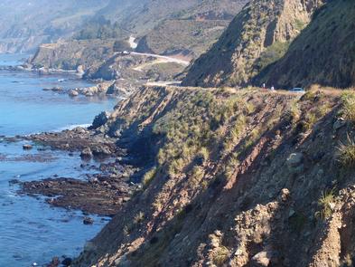
Route 1 - San Luis Obispo North Coast Byway
The San Luis Obispo North Coast Byway provides an extraordinary experience. The unique geographic sections of the corridor offer a mosaic of experiences. From Hearst Castle, to Morro Estuary and the Pacific, to the outdoor recreation of hiking, biking, and kayaking, the corridor offers something for everyone.
RecAreaDirections
Getting to the Byway:
Oakland International Airport, CA
* Head southeast on Airport Drive.
* Continue onto 98th Avenue.
* Merge onto I-880 S via the ramp to San Jose.
* Take exit 4B to merge onto US-101 S toward Los Angeles.
* Take the ramp to Monterey/Peninsula.
* Merge onto CA-156 W.
* Continue onto CA-1 S for approximately 91 miles until you reach the northern end of the byway.
San Francisco International Airport, CA
* Merge onto US-101 south.
* Merge onto CA-156.
* Merge onto CA-1 south.
* Route 1-Big Sur Coast Highway begins on CA-1 in the city of Carmel-By-The-Sea.
* Continue along Route 1 until you reach the Monterey County Line near Ragged Point, where the byway begins.
San Jose International Airport, CA
* Head southeast on Terminal Drive toward Airport Pkwy.
* Continue onto Airport Blvd.
* Continue onto Angelo Way.
* Turn left at Airport Blvd.
* Turn right to merge onto CA-87 S toward I-280/Downtown.
* Take exit 1A for State 85 S toward Gilroy.
* Merge onto CA-85 S.
* Merge onto US-101 S.
* Take the ramp to Monterey/Peninsula.
* Merge onto CA-156 W.
* Merge onto CA-1 S/Cabrillo Hwy.
* Follow CA-1 S/Cabrillo Hwy until you reach the byway.
Navigating the Byway:
* Start in San Luis Obispo, CA on Santa Rosa St.
* Drive northwest on Santa Rosa St.
* Continue north as the road changes to State Hwy. 1/Cabrillo Hwy.
* End at the San Luis Obispo county line, north of Ragged Point Vista.
Misc
| Stay Limit | |
| Reservable | false |
| Keywords | |
| Map Link | |
| Contact Phone | |
| Contact Email |
Permits info
Facilities
no data available
