
Deschutes National Forest
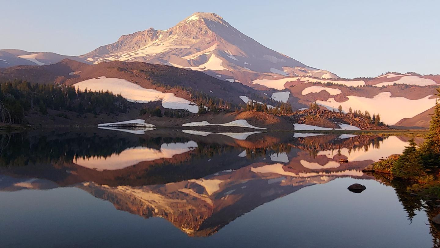
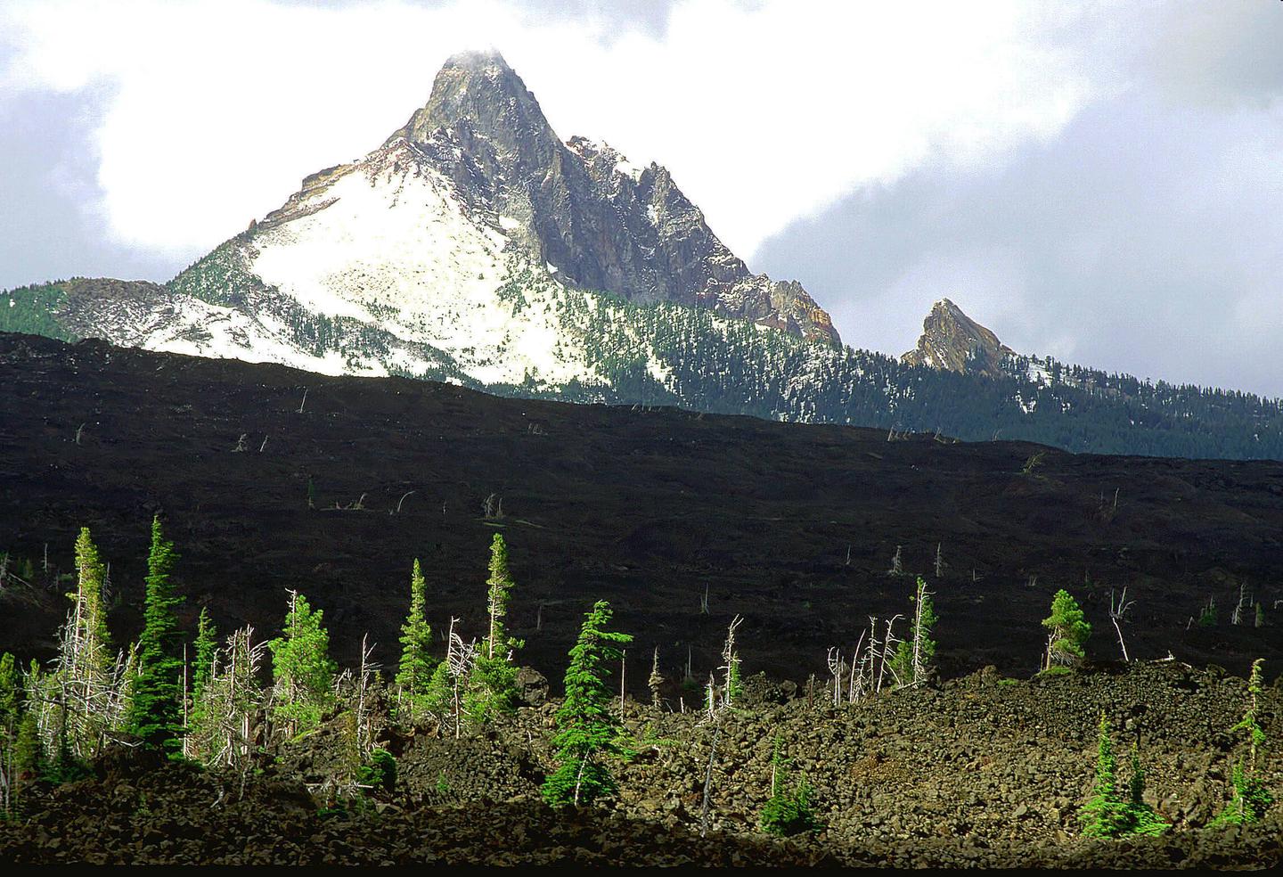
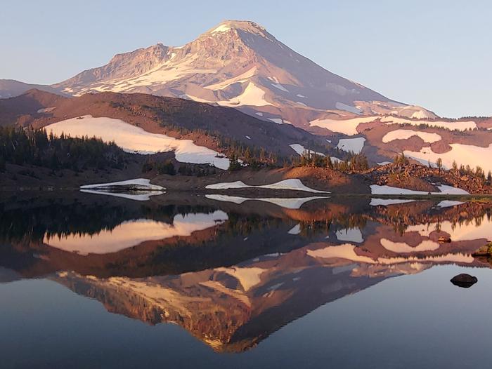
 Located on the eastern slopes of the Cascades in Central Oregon, the Deschutes National Forest offers year-round recreation opportunities. Home to more than 1.6 million acres, the Forest spans a variety of landscapes and ecosystems. The Forest gains more than 9,000 feet in eleveation from its lowest point at Lake Billy Chinook (1,950 ft) to its highest atop South Sister's summit (10.358 ft).
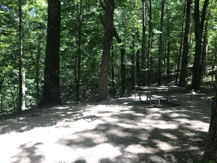
With more than 80 campgrounds across the Deschutes National Forest, visitors enjoy campsites featuring a wide-variety of picturesque backdrops. Camping opportunities range from rustic, walk-in sites to sites accomodating full-size RV's and trailers.
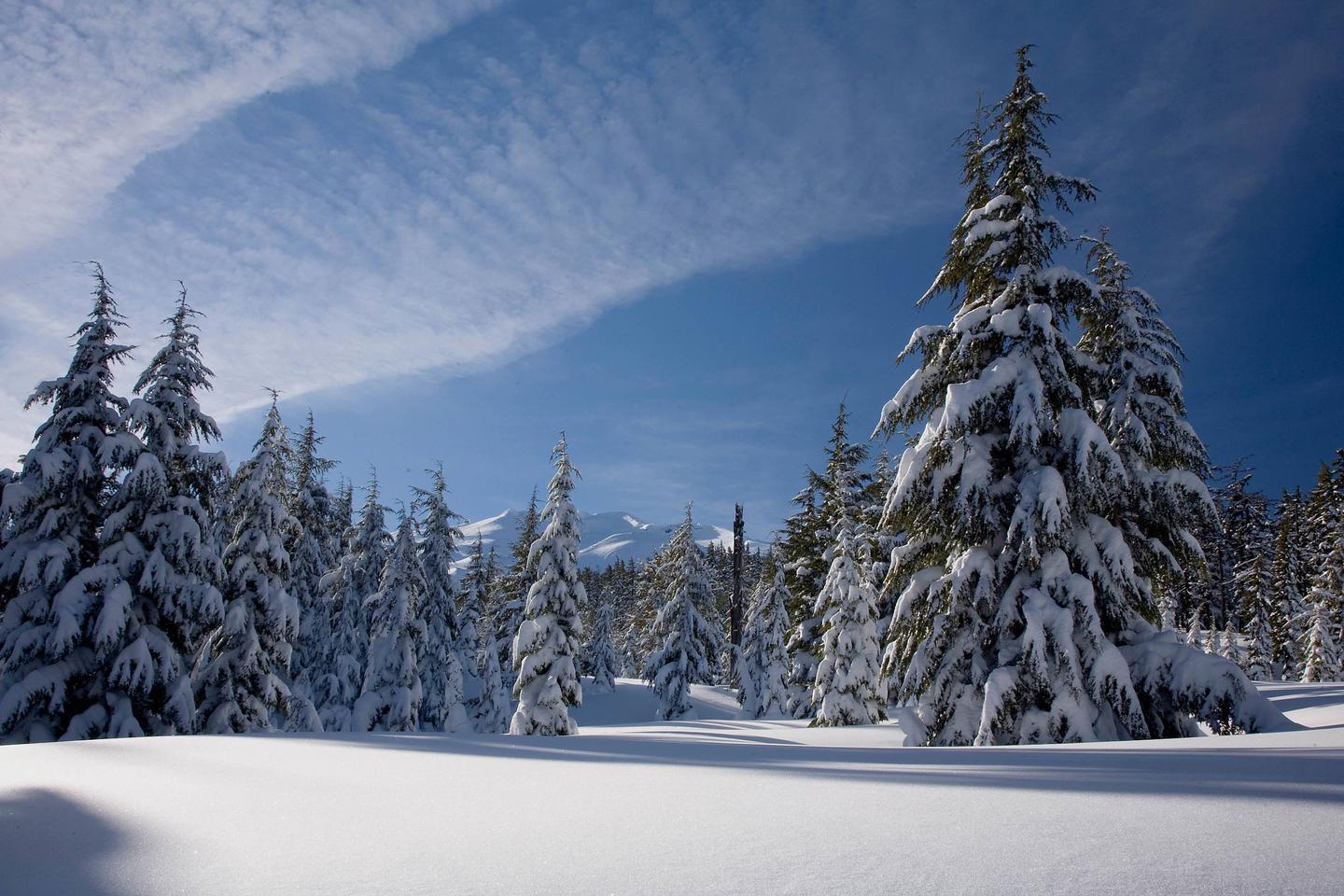
Five wilderness areas fall within the Deschutes National Forest boundary--Diamond Peak Wilderness, Mt. Jefferson Wilderness, Mt. Thielsen Wilderness, Mt. Washington Wilderness and Three Sisters Wilderness. Each wilderness offers visitors a unique experience; from sweeping summit views to alpine lakes, these areas provide the perfeect backdrop for a day hike or backpacking trip.
Three scenic byways wind through the Forest--Cascade Lakes Scenic Byway, McKenzie Pass-Santiam Pass Scenic Byway and the Outback Scenic Byway. The Cascade Lakes Scenic Byway heads west out of Bend, winds up past Mt. Bachelor before depositing visitors at the base of South Sister and Broken Top, as well as prodviding access to dozens of lakes. The McKenzie Pass-Santiam Pass Scenic Byway leaves Sisters, before climbing two passes and carveing through 82 miles of wide-open lava fields interspersed among desnse forest canopy. The Outback Scenic Byway stretches through the southeastern portion of Central Oregon, covering 171 miles of geologic wonder.
Deschutes National Forest Interactive Visitor Map
RecAreaDirections
Open with Google Map
Misc
| Stay Limit | |
| Reservable | false |
| Keywords | |
| Map Link | |
| Contact Phone | |
| Contact Email |
Permits info
Facilities
Crescent Lake Yurts Campground
List of CampsitesOverview
The Crescent Lake Yurts are located within Crescent Lake Campground on the northwestern shore of Crescent Lake at the eastern base of the Cascade mountain range. Yurts are managed by the Crescent Ranger District of the Deschutes National Forest.
Recreation
The Crescent Lake area offers a wide-variety of recreation opportunities. The Crescent Lake Day Use Area provides boat launch access to the lake. Crescent Lake is a popular destination for boating, swimming, fishing and paddling.
Fawn Lake Trailhead departs from the Crescent Lake Campground and Day Use Area providing hiking access into the Diamond Peak Wilderness.
Facilities
The Crescent Lake Yurts feature three individual yurt sites located within the Crescent Lake Campground. Furnished yurts include one bunkbed with one double and one single mattress, one double futon, table and chairs and a wood stove. Each yurt site also features a fire ring and picnic table.
During summer months, visitors have access to drinking water within the Crescent Lake Campground. Yurts do not have electricity. Visitors should be prepared to bring their own linens, cooking utensils and lighting source.
Natural Features
Crescent Lake sits within a glaciated basin behind a moraine dam east of the Cascade mountain range in northern Klamath County. From within the Crescent Lake basin, visitors will catch views of Diamond Peak and the unique Cowhorn Mountain. Crescent Lake is a popular recreation destination with brilliant blue-green water and sandy beaches.
The Crescent Lake Yurts are situated within a predominately ponderosa pine stand on the western edge of the Crescent Lake Campground.
Nearby Attractions
contact_info
This location is unstaffed. To speak with our main office for general information, please call: (541) 433-3200.Charges & Cancellations
A customer who cancels a reservation the day before or on the day of arrival will pay a $10.00 service fee AND forfeit the first night's use fee (not to exceed the total paid for the original reservation). Cancellations for a one-night reservation will forfeit the entire amount paid and will not be subject to an additional service fee.
Changes or Cancellations within the Cut-off Window: Once a reservation date has begun, customers cannot change a reservation using the online system or through the Call Center.
Lava River Cave Timed Reservation Tickets Timed Entry
Lava River Cave, part of the Newberry National Volcanic Monument, offers self-guided exploration of a mile-long lava tube. Formed 75,000 years ago during a dramatic eruption of Newberry Volcano, Lava River Cave was one of the first lava tubes to be discovered in Oregon and is the longest continuous cave in the state. It takes approximately 1 hour to tour the entire cave (~2.2 miles roundtrip). Initial access descends stairs to a combination of flat boardwalk, and uneven walking surfaces. Located near the city of Bend, OR Lava Rive Cave is a popular tourist destination and an excellent location for the general public to be exposed to caving.
NEWBERRY GROUP CAMP SITE Campground
List of CampsitesOverview
Boasting some of central Oregon's most spectacular scenery, Newberry Group Campground is the only exclusive group site area within the Newberry National Volcanic Monument.
Located along the south shore of Paulina Lake in Deschutes National Forest, this site offers a unique geological glimpse into the area's one-of-a-kind landscape and volcanic activity.
Recreation
The unique location of Newberry Group Campground offers outdoor enthusiasts fantastic opportunities for bird watching, boating, bicycling, sightseeing and hiking throughout the year. The Paulina Lakeshore loop trail passes thru this campground and offers a 7 mile stroll around Paulina Lake. Bird watchers may catch a glimpse of bald eagles and osprey nesting nearby. Common loon, Grebe, Tundra swan, Eurasian wigeon, American wigeon, Ring-necked duck, Goldeneye, and Hooded Merganser are lured to Paulina Lake as well. Visitors can drive or hike to the summit of nearby Paulina Peak to watch soaring raptors such as golden eagle, turkey vulture, prairie falcon and red-tailed hawk.Facilities
Three separate group sites offer visitors opportunities for both lakeside and forest camping. Picnic areas, shoreline trails, and stunning views of the lake give visitors the opportunity to enjoy the outdoors. The parking area and roads throughout the campground are paved.Natural Features
Paulina Lake is located within the collapsed caldera of Newberry Volcano. Nearly five miles in diameter, this caldera encircles the basins of Paulina Lake, and its twin, East Lake. Covering an area of 1,531 acres, Paulina Lake, the larger and deeper of the two, plunges to depths of 250 feet.
Neither lake receives water from an inlet stream, but instead, are fed solely by rain, snowmelt, and hot springs. Paulina Creek drains the lake and has chiseled a narrow gorge through the caldera's west wall creating a remarkable twin waterfall.
Thermal vents and hot springs along the lake's northeast edge help create a highly productive ecosystem.
Wetlands, diverse forests, and rocky slopes near the campground provide a necessary habitat for shorebirds, racoon, deer, bats, and the occasional black bear.
In September, the outlet of Paulina Lake may become choked with kokanee salmon swimming to spawn in Paulina Creek.
Nearby Attractions
Visitors can explore wilderness areas, wild and scenic rivers, lakes and reservoirs, and approximately 1,600 miles of trails throughout Deschutes National Forest and the adjacent Ochoco National Forest.Lava Lands Visitor Center in nearby Bend, Oregon, offers visitors the opportunity to learn about the diverse landscape and history of the area through interpretive programs.
Visitors can explore the Lava River Cave, also located in the Newberry National Volcanic Monument. At a length of 5,211 ft. (1,588 m), the northwest section of the cave is the longest continuous lava tube in Oregon.
Charges & Cancellations
Once your reservation start date has begun, neither the Recreation.gov Contact Center nor the campground manager will be able to modify your reservation.
WHITEFISH HORSE CAMP Campground
List of CampsitesOverview
In Deschutes National Forest, Whitefish Horse Campground offers visitors some of the most stunning scenery in central Oregon and easy access to an abundance of recreational activities in the Cascade region.A favorite among horse enthusiasts, the campground looks out onto the waters of Crescent Lake. With snow-capped peaks, high elevation lakes, scenic rivers, and several wilderness areas located nearby, this campground offers visitors the opportunity to experience both the serene and wild aspects of central Oregon.
Recreation
A favorite among horse enthusiasts, the campground provides visitors with access to a variety of trails. Lakes, lava flows, and forested areas provide the backdrop for many of these rides.Whitefish Creel Trail is popular with both hikers and horseback riders. This trail can be accessed from the west end of Crescent Lake and follows Whitefish Creek up through lodgepole pines to a beautiful view of Diamond Peak at Diamond View Lake. From there, the trail descends along Trapper Creek through Engelmann spruce and white fir to the west end of Odell Lake.
Equestrians may want to traverse at least a portion of the spectacular Pacific Crest Trail (PCT), one of America's premier National Scenic Trails. This trail showcases some of North America's most fantastic scenery, winding its way its way from Mexico to Canada through California, Oregon and Washington. Portions of the trail traverse Diamond Peak at timberline. Wilderness passes are required for this trail.
Facilities
The campground has 17 large equestrian sites, each equipped with double or quadruple metal corrals. Sites 008, 013 and 018 have four horse stalls, while all the others have two horse stalls.Picnic tables, campfire rings/grills, and ample room for parking vehicles and trailers are available at each site. Drinking water is also available, as is access to vault toilets.
Horse campgrounds have been designed to accommodate people who need to corral their horses. With a limited number of these kinds of campgrounds, please consider camping in one of the many other campgrounds nearby if you do not have a horse.
This horse camp is open usually by Memorial Day, or after snow levels recede. It stays open until snow blocks the road, typically around Thanksgiving. However, water and host services may not be provided after early October.
Natural Features
Cresent Lake is nestled in a naturally glaciated basin behind a moraine dam, east of the towering Cascade Mountain Range. Its brilliant blue-green water, sandy beaches, and water temperature are exceptional for a high-elevation lake.The area provides habitat for mammals such as mule deer, coyote, and cougar. Migratory birds and native fish also call the area home. These species, along with many others, depend on surrounding undeveloped wilderness, clean streams, and diverse forests to live.
Nearby Attractions
Visitors can explore wilderness areas, wild and scenic rivers, lakes and reservoirs, and approximately 1,600 miles of trails in the 2.5 million-acre Deschutes National Forest and adjacent Ochoco National Forest.Lava Lands Visitor Center in Bend, Oregon, is a great starting point for visitors to learn about the diverse landscape and history of the area through interpretive programs and exhibits.
Visitors may also enjoy traveling the Cascade Lakes Scenic Byway. The 66-mile drive through the Cascade Mountain range, weaves through snow-capped peaks and alpine lakes, highlighting the beauty of central Oregon.
Charges & Cancellations
Once your reservation start date has begun, neither the Recreation.gov Contact Center nor the campground manager will be able to modify your reservation.
Simax Group Camp Campground
List of CampsitesOverview
Simax Group Campground is located on the northeast end of Crescent Lake in Deschutes National Forest, offering visitors some of the most beautiful scenery in central Oregon and easy access to an abundance of recreational activities.Designed as a fully accessible campground, the four group sites and large picnic pavilion provide all visitors with ample opportunities to explore the area's diverse lush forest and spectacular surroundings.
Recreation
At Simax Group Campground, water skiing, sailing, windsurfing, sunning, hiking, mountain biking, horseback riding, off-roading and fishing are popular with visitors.Hiking on one or more of the trails in the area offers a wide variety of scenic terrain, ranging from lakeside trails to routes weaving through towering pine, fir, and spruce trees, typical for the area.
For anglers, Crescent Lake provides the perfect setting to fish from boat or the shoreline. Fish species found in the lake include kokanee salmon, mackinaw, rainbow trout, brown trout and mountain whitefish. Summer months offer the best fishing.
Facilities
Four separate group sites offer visitors opportunities for both lakeside and forest camping.Picnic areas, sandy beaches and stunning views of the lake, along with the conveniences of drinking water and flush toilets, give visitors the opportunity to enjoy the outdoors while still having many of the conveniences of home.
The roads and spurs throughout the campground are paved.
This site was designed to be fully accessible for those with disabilities and is the first of its kind in the Northwest. A trail system designed for accessibility links the group site to the day-use areas and beaches.
Natural Features
Crescent Lake, nestled in a naturally glaciated basin behind a moraine dam, lies east of the towering Cascade Mountain Range. Its brilliant blue-green water, sandy beaches and water temperature are exceptional for a high-elevation lake.Towering lodgepole pine trees provide the backdrop for this area, with mountain hemlock, fir, and spruce also in the mix.
Volcanic activity throughout the surrounding area of Deschutes National Forest is evident in its landscape, showcasing cinder cones, calderas and lava flows.
Nearby Attractions
The trailhead to Fawn Lake starts at the northeast end Crescent Lake and is open to hikers and horseback riding. The trail, 4.7 miles one-way, begins in a forest of white fir, Douglas fir and mountain hemlock before making a transition into lodgepole pine, ending at the Crater Butte Trail near Fawn Lake. There are views of Redtop and Lakeview Mountains at Fawn Lake.Lava Lands Visitor Center in Bend, Oregon, offers visitors the opportunity to learn about the diverse landscape and history of the area through interpretive programs and exhibits.
Visitors will also enjoy traveling the Cascade Lakes Scenic Byway, known as Oregon's Highway in the Sky, which climbs into the clouds on a 66-mile drive through the Cascade Mountain range, weaving through snow-capped peaks and alpine lakes.
A nearby resort on Crescent Lake offers lodging and a general store. Supplies and equipment rentals are available to visitors.
Charges & Cancellations
Once your reservation start date has begun, neither the Recreation.gov Contact Center nor the campground manager will be able to modify your reservation.
BLUE BAY Campground
List of CampsitesOverview
Blue Bay Campground is situated in a diverse forest of pine and fir on the south shore of Suttle Lake in Deschutes National Forest. Its proximity to high alpine lakes, lush forests and towering peaks in nearby wilderness areas make it a popular destination for individual and group camping excursions.Recreation
Popular activities in the area include hiking, fishing and motorized boating in the summer months, as well as cross-country skiing and snowshoeing in the winter.Numerous hiking and horseback riding trails can be accessed from the campground and in the surrounding area. The 3.2-mile Suttle Lake Loop Trail meanders through the developed recreation areas on Suttle Lake. The trail follows the wooded shoreline of the lake, providing opportunities for fishing or picnicking along the way.
For fishing, boats are most commonly used on Suttle Lake. Float tubes are adequate, and wading is possible in some areas. A few areas are fishable from shore. The lake sustains an excellent population of naturally reproducing kokanee, brown trout, whitefish and crayfish.
The campground has a shallow boat ramp area, and most campsites have easy access to the waterfront. Motorized and non-motorized boats are allowed on Suttle Lake.
Facilities
Blue Bay Campground offers standard sites that accommodate both tents and RVs, but no hookups are available. Picnic tables and campfire rings with grills are provided, as are vault toilets and drinking water.Natural Features
Suttle Lake is surrounded by mixed conifer forest. Its waters are deep and clear, formed in a terminal moraine, deposited by glacial ice about 25,000 years ago.Lake Creek flows eastward from Suttle Lake to the Metolius River. The clear, cold Metolius flows north from headwater springs through diverse coniferous forests and a volcanic landscape with extinct volcanoes, cinder cones, calderas and ancient lava flows.
Nearby Attractions
Visitors can explore wilderness areas, lakes, reservoirs, wild and scenic rivers and approximately 1,600 miles of trails that comprise nearly 2.5 million acres within the Deschutes National Forest and the adjacent Ochoco National Forest.LINK CREEK Campground
List of CampsitesOverview
Link Creek Campground is situated on the shores of Suttle Lake in the Deschutes National Forest. Visitors enjoy boating, fishing, hiking and biking in summer, and cross-country skiing and snowshoeing in winter.Recreation
Popular activities in the area include hiking, fishing and motorized boating in the summer months, and cross-country skiing and snowshoeing in winter months. Numerous hiking mountain biking trails are accessible from the campground and in the surrounding area. The 3.2 mile Suttle Lake Loop Trail meanders through the developed recreation areas on Suttle Lake. The trail is relatively flat and follows the wooded shoreline of the lake, providing opportunities for fishing or picnicking along the way. A boat ramp is located within the campground. Motorized and non-motorized boats are allowed on Suttle Lake.Facilities
Link Creek Campground offers tent and RV campsites, as well as yurts. Campsites are equipped with tables and campfire rings with grills. Vault toilets and drinking water are provided. Electrical hookups are not available.While the campsites are pet-friendly, unfortunately pets are not permitted within the yurts.The yurts are available for reservation year-round. Each is equipped with a bunkbed with one double and one single mattress, double futon, table and chairs and a wood stove. Visitors need to bring their own linens, lantern and eating essentials. No electricity is available.
Natural Features
Suttle Lake is surrounded by a mixed conifer forest. The lake is deep and clear. The lake covers an area of 253 acres and has an average depth of 44 feet. It sustains an excellent population of naturally reproducing kokanee, brown trout, whitefish, and crayfish.Link Creek, which empties into Suttle Lake, is shallow and clear enough to view spawning fish. Lake Creek flows eastward from Suttle Lake and eventually joins the Metolius River.
In autumn, the local vine maple trees display brilliant orange, red and yellow foliage.
Nearby Attractions
Visitors can explore wilderness areas, rivers, lakes and reservoirs, and approximately 1,600 miles of trails that comprise nearly 2.5 million acres within the Deschutes National Forest and the adjacent Ochoco National Forest.Visitors enjoy traveling the Cascade Lakes Scenic Byway, known as Oregon's Highway in the Sky, which climbs into the clouds on a 66-mile drive through the Cascade Range, weaving past snow-capped peaks and alpine lakes.
Charges & Cancellations
Once your reservation start date has begun, neither the Recreation.gov Contact Center nor the campground manager will be able to modify your reservation.
Scout Lake Campground
List of CampsitesOverview
Scout Lake Group Campground sits near the shores of its namesake in Deschutes National Forest. Its proximity to high alpine lakes, lush forests and towering peaks in nearby wilderness areas make it a popular destination for outdoor enthusiasts.
Recreation
Water sport enthusiasts of all types will enjoy the opportunities available at Scout Creek Lake and nearby Suttle Lake. Only non-motorized watercraft are allowed on Scout Creek, but water skiing, fishing and boating are popular at Suttle Lake, less than one mile away.Nearby trails and a picturesque shoreline offer visitors opportunities for hiking, birding, wading and swimming at Scout Lake, and a large beach is located just steps away.
Facilities
There are 10 sites at this campground. Site #6 is a single family site while 3, 4A, 4B, 5, 7 and 8 are doubles. Sites 1, 2 and 9 are triples. If the entire campground is rented together, it will comfortably accommodate up to 100 guests. A large day-use area with 11 picnic tables and parking for 50 vehicles makes this area perfect for large parties and family functions.All sites are equipped with tables and campfire rings with grills.
There are three vault toilets and a gravity fed water system.
Natural Features
The campground sits at 3,600 feet in the high desert region of central Oregon in a towering mixed conifer forest. Nearby landscapes showcase the unique volcanic activity throughout the region, and visitors can explore extinct volcanoes, calderas and lava flows typical in the area.The surrounding undeveloped wilderness, clean streams and diverse forests support an abundance of wildlife, including deer, squirrel, trout, salmon and a variety of migratory birds.
Nearby Attractions
Visitors can explore wilderness areas, rivers, lakes, reservoirs and approximately 1,600 miles of trails that comprise nearly 2.5 million acres the Deschutes National Forest and the adjacent Ochoco National Forest.Lava Lands Visitor Center in nearby Bend, Oregon, and the Newberry National Volcanic Monument are popular attractions as well.
Visitors will also enjoy traveling the Cascade Lakes Scenic Byway, known as Oregon's Highway in the Sky, which climbs into the clouds on a 66-mile drive through the Cascade Mountain range, weaving through snow-capped peaks and alpine lakes.
Charges & Cancellations
Once your reservation start date has begun, neither the Recreation.gov Contact Center nor the campground manager will be able to modify your reservation.
South Shore Campground
List of CampsitesOverview
South Shore Campground is located along Suttle Lake, shaded by Douglas fir and Ponderosa pine. One section of the camp sits on the shoreline, while the other is nestled on a hillside.Most sites have lake views. The 3,400-foot elevation and the lake breezes make South Shore Campground a comfortable summertime destination.
Recreation
There is a boat launch available at this camp. Popular activities include power and non-motorized boating, sailing, water skiing and wind surfing.Anglers can fish for rainbow trout, kokanee salmon and brown trout, and there is a fish cleaning station on-site. Hikers and mountain bikers have access to the 3.2-mile Suttle Lake Shoreline Trail.
Facilities
Each site has a gravel parking spur, picnic table and campfire ring. Dump stations are dispersed through the campground.Drinking water and vault toilets are provided.
Natural Features
Nestled along the Cascade Mountains, the Deschutes National Forest is one of the most popular recreation forests in the Pacific Northwest. It offers a variety of landscapes, from fields of sagebrush and hay to old-growth forests and glacier-carved volcanic peaks.Suttle Lake is a natural lake formed by glaciers. It has a forested shoreline and offers views of nearby Mt. Washington.
Nearby Attractions
The town of Sisters is about 15 miles away, offering shopping and restaurants.Charges & Cancellations
Once your reservation start date has begun, neither the Recreation.gov Contact Center nor the campground manager will be able to modify your reservation.
OGDEN GROUP Campground
List of CampsitesOverview
Ogden Group campground is located in the high desert region of central Oregon, on the scenic Paulina Creek. The campground is surrounded by scenery that sets the stage for fantastic recreational opportunities in Deschutes National Forest.
This group campground is ideal for large scout groups, school outings, and family reunions, and provides plenty of opportunities for excursions to scenic rivers, lakes, and lava flows, typical to the area.
Recreation
Boating, swimming and fishing are popular activities enjoyed by visitors during spring, summer and fall months, while skiing and snowmobiling are popular during the winter.Anglers have the opportunity to fish in the surrounding clear, cold lakes and streams for abundant salmon and trout.
Hikers and backpackers have access to a variety of trails in the area, including several in Newberry National Volcanic Monument.
The Crater Rim Trail is a favorite high country trail, boasting vast stretches of forest, deserts, and mountains extending from all sides of the trail.
The Peter Skene Ogden National Scenic Trail is accessible from the campground and parallels Paulina Creek, passing several waterfalls along the way, as it ascends 8.5 miles to the spectacular Paulina Lake.
Facilities
Ogden Group Campground is a large campground, offering two spacious sites for group tent and RV camping.Each of the sites can accommodate at least 150 people and both sites may be reserved at once for up to 350 people and greater privacy.
Tables, vault toilets and drinking water are available at the campsite.
Natural Features
Visitors can get a glimpse of area's unique geological features by exploring nearby Newberry National Volcanic Monument. While exploring the Monument, visitors are able to see numerous cinder cones and basalt flows as well as rhyolite flows of obsidian, indicative of a history of spectacular volcanic activity.Newberry Crater, a 17-square-mile caldera at the summit of the 500-square-mile volcano, is both seismically and geothermally active. Geologists believe the caldera sits over a shallow magma body only 2 to 5 kilometers deep.
At an elevation of 7,985 ft., Paulina Peak, the highest point in the Monument, showcases views of the Oregon Cascades and the High Desert region. Visiting the summit area of Newberry Volcano, visitors will encounter sparkling alpine lakes full of trout and salmon.
Nearby Attractions
Lava Lands Visitor Center in nearby Bend, Oregon, is a great starting point for visitors to learn about the diverse landscape and history of the area through interpretive programs and exhibits.Visitors can explore the Lava River Cave, also located in the Newberry National Volcanic Monument. At 5,211 feet (1,588 m) in length, the northwest section of the cave is the longest continuous lava tube in Oregon.
Charges & Cancellations
Once your reservation start date has begun, neither the Recreation.gov Contact Center nor the campground manager will be able to modify your reservation.
WINDY GROUP CAMP Campground
List of CampsitesOverview
Located on the southwest end of spectacular Crescent Lake in Deschutes National Forest, Windy Group Campground offers visitors the opportunity to experience the beauty and recreational opportunities of the Cascade region in a rustic and secluded setting.A large group site sits at the lake's edge. Visitors enjoy hiking nearby trails and water activities on the lake.
Recreation
Boating, swimming and fishing are popular activities enjoyed by visitors during spring, summer and fall months. Anglers have the opportunity to fish from boat or shoreline for abundant salmon and trout. Summer months offer the best fishing.Crescent Lake Snowpark offers skiers and snowmobilers a base camp for winter excursions. Open to snowmobiling, Summit Lake Trail, about 9 miles one-way, follows the road leading from Crescent Lake to Summit Lake, offering excellent views across Crescent Lake and showcasing Diamond Peak.
Facilities
This large group site can accommodate up to 40 people.Amenities are minimal at this campground. There is one wooden style vault toilet. Picnic tables and a barbeque pit are available.
The roads are unpaved, and RVs will have plenty of space to park.
Natural Features
Crescent Lake, nestled in a naturally glaciated basin behind a moraine dam, lies east of the towering Cascade Mountain Range. Its brilliant blue-green water, sandy beaches and water temperature are exceptional for a high-elevation lake.Towering lodgepole pine trees provide the backdrop for this area, with mountain hemlock, fir, and spruce also in the mix.
Volcanic activity throughout the surrounding area of Deschutes National Forest is evident in its landscape, showcasing cinder cones, calderas and lava flows.
Nearby Attractions
Visitors can explore wilderness areas, wild and scenic rivers, lakes and reservoirs and approximately 1,600 miles of trails that comprise nearly 2.5 million acres the Deschutes National Forest and the adjacent Ochoco National Forest.Lava Lands Visitor Center in nearby Bend, Oregon, and the Newberry National Volcanic Monument draw visitors to the region as well.
Visitors will also enjoy traveling the Cascade Lakes Scenic Byway, known as Oregon's Highway in the Sky, which climbs into the clouds on a 66-mile drive through the Cascade Mountain range, weaving through snow-capped peaks and alpine lakes.
A nearby resort on Crescent Lake offers lodging and a general store where supplies and equipment rentals are available.
Charges & Cancellations
Once your reservation start date has begun, neither the Recreation.gov Contact Center nor the campground manager will be able to modify your reservation.
Cinder Hill Campground Campground
List of CampsitesOverview
Cinder Hill Campground sits at the edge of beautiful East Lake in the caldera of Newberry Volcano. The area is part of the Newberry National Monument in Deschutes National Forest. The area is popular for its geological significance and multitude of recreational activities, making it an ideal individual and family camping excursion.
Recreation
Visitors can take advantage of boating, kayaking, swimming and fishing on East Lake. A boat ramp is located in the campground, and the lake has a 10 mph speed limit.For anglers, the lake provides the perfect setting to fish from boat or the shoreline. It supports rainbow trout, brown trout and Kokanee salmon. In September, the outlet of adjacent Paulina Lake may be choked with Kokanee moving to spawn in Paulina Creek.
The Crater Rim Trail, considered one of the finest high country trails in the area, boasts vast stretches of forest, deserts and mountains. The trail has many access points and connectors to other trails.
Facilities
Cinder Hill Campground offers several sites close to the shore or within easy walking distance to the beach. It is an ideal campground for those hauling trailers, but it also has plenty of sites perfect for tents. Sites are equipped with tables and campfire rings with grills. Flush toilets and drinking water are also available.Natural Features
East Lake is located within the collapsed crater, or caldera of Newberry Volcano. Nearly five miles in diameter, the caldera encircles the basins of East Lake and Paulina Lake. East Lake covers 1,044 acres and is 180 feet at its deepest point.Paulina Creek flows from the lake and has chiseled a narrow gorge through the caldera's west wall creating a remarkable twin waterfall. Thermal vents and hot springs along the lake's northeast edge help create a highly productive ecosystem.
The surrounding undeveloped wilderness, clean streams and diverse forests support a variety of wildlife, including black bear, bighorn sheep, deer, native fish and migratory birds.
Nearby Attractions
Big Obsidian Flow Trail offers a 1-mile interpretive trail that climbs up and onto this impressive lava flow of obsidian (black volcanic glass) and pumice. The Big Obsidian Flow is 1300 years old, the youngest lava flow in Oregon.Lava Lands Visitor Center in nearby Bend, Oregon, is a great starting point for visitors to learn about the diverse landscape and history of the area through educational programs and exhibits.
Lava River Cave, also located in the Newberry National Volcanic Monument, is nearly a mile long. The northwest section of the cave is the longest continuous lava tube in Oregon.
A nearby resort, operating under a special use permit from the Deschutes National Forest offers visitors lodging, last minute essentials and boat rentals.
Charges & Cancellations
Once your reservation start date has begun, neither the Recreation.gov Contact Center nor the campground manager will be able to modify your reservation.
Gull Point Campground Campground
List of CampsitesOverview
Located on the shore of Wickiup Reservoir in Deschutes National Forest, Gull Point campground offers visitors easy access to an abundance of recreational activities along the Cascade Lakes National Scenic Byway.
Sites are scattered among a mixed, yet open conifer forest, giving sunshine a chance to filter through. Several sites sit on along the waterfront.
Recreation
Gull Point Campground offers visitors opportunities for hiking, boating, canoeing, swimming and fishing.
The reservoir's relatively warm water and cooler deep channels generate some of the best fishing in Central Oregon. The area is renowned for its brown trout, often reaching 20 pounds, with normal catches in the 5-to-8 pound range. The reservoir also sustains good numbers of kokanee and coho salmon and decent populations of rainbow trout, brook trout, whitefish and chub.
Facilities
Gull Point campground offers spacious campsites for both tent and RV camping.
Picnic areas, drinking water, vault toilets and a dump station help visitors enjoy the outdoors in a comfortable setting.
There are also two large day-use areas, with boat launches and fish cleaning stations at each.
Natural Features
The reservoir covers an area on the Deschutes River that was historically used by Native Americans during the fall. Several tribes throughout the area built "wickiups," shelters made from reeds, grass, or brush, while living in the area.
At full pool, Wickiup is a beautiful, pine-edged reservoir, with some willows and sandy beach areas. At low water, steep soil and gravel banks drop abruptly to the water.
This is one of central Oregon's best wildlife viewing sites, attracting a variety of nesting and migrating birds. Fantastic nearby peaks, lava flows and forests also provide visitors with a variety of landscapes.
Wetlands, diverse forests, and rocky slopes near the campground provide a necessary habitat for shorebirds, porcupine, deer, bats and the occasional black bear.
Nearby Attractions
Lava Lands Visitor Center in nearby Bend, Oregon, is a great starting point for visitors to learn about the diverse landscape and history of the area through interpretive programs and exhibits.
Visitors can also explore the Lava River Cave, located in the Newberry National Volcanic Monument. At 5,211 feet in length, the northwest section of the cave is the longest continuous lava tube in Oregon.
Charges & Cancellations
Once your reservation start date has begun, neither the Recreation.gov Contact Center nor the campground manager will be able to modify your reservation
Chief Paulina Horse Camp Campground
List of CampsitesOverview
Chief Paulina Horse Camp is the only horse campground located in Newberry National Volcanic Monument in Deschutes National Forest. A favorite for horse enthusiasts, the campground provides visitors with access to lakes, lava flows and spectacular geologic features.
Recreation
Visitors on horseback can explore the area on a variety of trails, with several trailheads located at the campground. Lakes, lava flows and forested areas provide a beautiful scenic backdrop for a variety of rides.The Crater Rim Trail, considered one of the premiere high country trails in the area, boasts vast stretches of forest, desert and mountain views, with many access points and connector trails for convenient and customized rides.
For visitors who enjoy hiking, the Peter Skene Ogden National Scenic Trail parallels Paulina Creek as it ascends 8.5 miles to the spectacular Paulina Lake.
Lost Lake Trail traverses drier landscapes and heads up from the lakes into a more arid part of the Newberry Caldera. This trail affords some excellent views of The Big Obsidian Flow as well as pumice flats and other features of Newberry Volcanic National Monument. The start of the trail is near Big Obsidian Flow.
Facilities
All sites are reservable at this campground. There are basic amenities for horse camping, including large equestrian sites with double or quadruple corrals and ample room for parking vehicles and trailers. Roads in the campground are unpaved as are the parking spurs. The campground parking was reconstructed in the fall of 2018 to allow for larger vehicle trailer combinations and some sites were modified to accomodate pull thru parking.
While there is a water tank for the live stock, no potable drinking water is available. Restaurants and basic supplies are available at nearby resorts. Monument information is available at the nearby Paulina Visitor Center.
Natural Features
Visitors can catch a glimpse of the area's unique geological features by exploring nearby Paulina Lake, located within the collapsed caldera of Newberry Volcano. The lake covers a surface area of 1,531 acres and reaches depths of up to 250 ft., but neither Paulina Lake or its twin, East Lake, receives water from an inlet stream. Instead, each lake relies on relies on rain, snowmelt and hot springs for water. Paulina Creek drains the lake and has chiseled a narrow gorge through the caldera's west wall creating a remarkable twin waterfall. Thermal vents and hot springs along the lake's northeast edge help create a highly productive ecosystem. Wetlands, diverse forests, and rocky slopes near the campground provide a necessary habitat for shorebirds, racoons, deer, bats, and the occasional black bear. In September, the outlet of Paulina Lake may be choked with Kokanee salmon moving to spawn in Paulina Creek.Nearby Attractions
Lava Lands Visitor Center in nearby Bend, Oregon, is a great starting point for visitors to learn about the diverse landscape and history of the area through interpretive programs and exhibits.Visitors can explore the Lava River Cave, also located in the Newberry National Volcanic Monument. At 5,211 feet (1,588 m) in length, the northwest section of the cave is the longest continuous lava tube in Oregon.
Charges & Cancellations
Once your reservation start date has begun, neither the Recreation.gov Contact Center nor the campground manager will be able to modify your reservation.
Trapper Creek Campground Campground
List of CampsitesOverview
Trapper Creek Campground is located in the Crescent Ranger District of Deschutes National Forest. Heavily forested and situated on a small stream that feeds into Odell Lake, this campground is a favorite in the area.Sparkling lakes, tranquil streams and nearby scenic peaks provide visitors with the perfect backdrop for fishing, boating, hiking and biking throughout the area.
Recreation
Boating, swimming and fishing are popular activities enjoyed by visitors during spring, summer and fall. Anglers have the opportunity to fish in clear, cold lakes and streams for abundant salmon and trout. Cross-country skiing and snowshoeing are popular during the winter.For anglers, Odell Lake is considered one of the blue giants of the Deschutes National Forest. This large lake has an average depth is 132 feet, which makes it ideal habitat for lake trout and bull trout. Rainbow trout, kokanee salmon and whitefish are also found in the lake.
Boats are the most effective way to fish this lake but visitors should be aware of afternoon winds, as the lake can get dangerously rough. A boat ramp is provided at the campground.
Facilities
Trapper Creek Campground offer sites that accommodate both tent and RV camping. The sites are secluded, and many are tucked away in thick forested areas.Sites are equipped with tables and campfire rings with grills. Drinking water are also available.
Natural Features
Nearby Odell Lake offers views across the water to Diamond Peak, the most prominent peak in nearby Diamond Peak Wilderness. At an elevation of 8,744 feet, this shield volcano formed as the entire Cascades mountain range was undergoing volcanic activity and uplift.Mixed stands of pine and fir trees tower over a variety of springtime flowers. Huckleberry is common in the underbrush of the campground.
Wildlife found in the area include deer, elk, pine martens, ravens, native fish and an occasional black bear.
Nearby Attractions
Visitors can explore wilderness areas, wild and scenic rivers, lakes and reservoirs and approximately 1,600 miles of trails that comprise nearly 2.5 million acres the Deschutes National Forest and the adjacent Ochoco National Forest.Lava Lands Visitor Center in nearby Bend, Oregon, and the Newberry National Volcanic Monument draw visitors to the region as well.
Visitors will also enjoy traveling the Cascade Lakes Scenic Byway, known as Oregon's Highway in the Sky, which climbs into the clouds on a 66-mile drive through the Cascade Mountain range, weaving through snow-capped peaks and alpine lakes.
A nearby resort on Odell Lake offers lodging and a general store with camping supplies, coffee, snacks and fishing licenses.
Charges & Cancellations
Once your reservation start date has begun, neither the Recreation.gov Contact Center nor the campground manager will be able to modify your reservation.
Paulina Lake Campground Campground
List of CampsitesOverview
Paulina Lake Campground is located 6,350 ft. above sea level in the caldera of Newberry Volcano, on the edge of the beautiful Paulina Lake. Conveniently located within Newberry National Monument, visitors to this area are taken aback by the incredible views this has to offer, highlighting volcanic landscapes intermixed with diverse forests, typical of central Oregon.
Popular for both its geological significance and multitude of recreational activities, Paulina Lake Campground is ideal for individual and family camping excursions.
Recreation
The unique location of Paulina Lake Campground offers visitors opportunities to hike shoreline trails and alpine vistas.
Visitors can also take advantage of time on the lake, boating, kayaking and fishing.
For anglers, this lake offers fantastic fishing opportunities. Spanning a surface area of 1,531 acres, the lake supports rainbow trout, brown trout and Kokanee salmon.
In September, the outlet of Paulina Lake may be choked with Kokanee moving to spawn in Paulina Creek.
Facilities
Paulina Lake campground has excellent sites for all forms of camping and plenty of large sites for RVs.Picnic areas, boating, shoreline trails, and stunning views of the lake, along with the conveniences of drinking water and flush toilets, give visitors the opportunity to enjoy the outdoors while still having many of the conveniences of home.
Natural Features
Paulina Lake is located within the collapsed crater, or "caldera" of Newberry Volcano. Nearly five miles in diameter, this caldera encircles the basins of Paulina Lake, and its twin, East Lake.Neither lake receives water from an inlet stream, but instead, rely on rain, snowmelt and hot springs for water. Paulina Creek drains the lake and has chiseled a narrow gorge through the caldera's west wall creating a remarkable twin waterfall. Thermal vents and hot springs along the lake's northeast edge help create a highly productive ecosystem.
Wetlands, diverse forests, and rocky slopes near the campground provide a necessary habitat for shorebirds, porcupine, deer, bats and the occasional black bear.
Nearby Attractions
Lava Lands Visitor Center in nearby Bend, Oregon, is a great starting point for visitors to learn about the diverse landscape and history of the area through interpretive programs and exhibits.Visitors can explore the Lava River Cave, also located in the Newberry National Volcanic Monument. At 5,211 feet (1,588 m) in length, the northwest section of the cave is the longest continuous lava tube in Oregon.
A rustic lodge near the campground, operating under a special use permit from the Deschutes National Forest, offers visitors lodging, last minute essentials and a cafe.
Charges & Cancellations
Once your reservation start date has begun, neither the Recreation.gov Contact Center nor the campground manager will be able to modify your reservation.
SMILING RIVER CAMPGROUND Campground
List of CampsitesOverview
Nestled in Deschutes National Forest, Smiling River Campground offers visitors some of the most stunning scenery in central Oregon and easy access to an abundance of recreational activities.Recreation
Hiking and fishing top the list of recreational activities for visitors.For anglers, the spring-fed Metolius river offers a stunning setting for fly-fishing. Its clear, cold water supports rainbow trout, whitefish, bull trout and kokanee salmon.
For day hikers and backpackers, the area offers a wide variety of scenic terrain, ranging from riverside trails to routes in subalpine forests.
Facilities
Smiling River Campground offers sites that accommodate both tent and RV camping, however hookups are not available.Picnic areas, trails and scenic overlooks, along with the conveniences of firewood, drinking water and flush toilets, give visitors the opportunity to enjoy the outdoors while still having many of the conveniences of home.
Natural Features
Many sites at this campground look out to Metolius River, a tributary of the Deschutes River.The headwaters of the river are at Metolius Springs at the base of Black Butte, a 3,076-foot cinder cone. The clear, cold river flows north from the springs through diverse coniferous forest and a landscape of volcanic activity.
The area provides habitat for mammals such as mule deer, coyote and cougar. Migratory birds and native fish also call the area home.
Nearby Attractions
The Metolius-Windigo Trail, open to hikers, bikers and horses, is more than 100 miles in length, and begins near the Metolius River headwaters west of the town of Sisters, Oregon. The trail was created in the 1980s primarily to serve long-distance horse riders seeking an alternative to the Pacific Crest Trail.Lava Lands Visitor Center in Bend, Oregon, offers visitors the opportunity to learn about the diverse landscape and history of the area through interpretive programs and exhibits.
Charges & Cancellations
Once your reservation start date has begun, neither the Recreation.gov Contact Center nor the campground manager will be able to modify your reservation.
CAMP SHERMAN CAMPGROUND Campground
List of CampsitesOverview
Camp Sherman Campground is nestled on the banks of the scenic Metolius River in Deschutes National Forest. It offers visitors some of the most stunning scenery in central Oregon and easy access to an abundance of recreational activities.Recreation
Hiking and fishing top the list of recreational activities at Camp Sherman Campground. Biking is a great way to see the area as well. Anglers enjoy fly-fishing for rainbow trout, whitefish, bull trout and kokanee salmon.Day hikers and backpackers will find a wide variety of hiking trails through scenic terrain, ranging from riverside trails to routes through subalpine forests.
Facilities
Camp Sherman Campground offers a handful of standard sites for both tent and RV camping, and one tent-only site. Each sites is equipped with a picnic table and campfire rings. Vault toilets and drinking water are provided, but electrical hookups are not available.Showers are available in the town of Camp Sherman, less than 2 miles from the campground.
Natural Features
Many sites at this campground have views of to Metolius River, a tributary of the Deschutes River, through Lake Billy Chinook, near the city of Sisters.Metolius Springs forms the headwaters of the river at the base of Black Butte, a 3,076' cinder cone. The clear, cold river flows north from the springs through diverse coniferous forest and a landscape of volcanic activity.
The area provides habitat for mammals such as mule deer, coyote and cougar. Migratory birds and native fish also call the area home.
Nearby Attractions
The Metolius-Windigo Trail begins near the Metolius River headwaters west of the town of Sisters. The trail is over 100 miles long and is open to hiking, biking and horseback riding. It was created in the 1980s by linking sections of existing trails, primarily to give long-distance horseback riders an alternative to the Pacific Crest Trail.Charges & Cancellations
Once your reservation start date has begun, neither the Recreation.gov Contact Center nor the campground manager will be able to modify your reservation.
Little Lava Lake Campground
List of CampsitesOverview
Little Lava Lake Campground is located along the Cascade Lakes National Scenic Byway in the Central Oregon Cascades.
Recreation
Little Lava Lake Campground provides recreation opportunities for fishing, paddling, swimming and hiking. For anglers, the 130-acre Little Lava Lake offers a quiet alternative to its larger neighbor to the north, Lava Lake. Reaching a maximum depth of 20 feet, the lake supports planted Rainbow trout, some Brook trout, and self-sustaining populations of Whitefish and Tui Chub. Bait, lures, flies, still fishing and trolling are all acceptable angling methods.
Facilities
Little Lava Lake Campground's campsites are predominately located under lodgepole pine canopy with some sites located along the lakeshore and the Deschutes River.
There is a boat ramp and a day use area that can be used at Little Lava Lake for a fee.
Natural Features
Little Lava Lake is located on the eastern slopes of the Cascade Mountain Range at an elevation of 4,740 feet. The small lake is surrounded by mature pine forests with bull rushes and lava outcroppings lining its shores.
Nearby Attractions
Visitors can explore wilderness areas, wild and scenic rivers, lakes and reservoirs and approximately 1,600 miles of trails within the Deschutes National Forest.
Lava Lands Visitor Center in nearby Bend, Oregon, and the unique geological landscape of Newberry National Volcanic Monument draw visitors to the region as well.
Visitors will also enjoy traveling the Cascade Lakes Scenic Byway which climbs into the Cascades over a 66-mile drive through snow-capped peaks and alongside alpine lakes.
A nearby resort on Lava Lake offers lodging and a limited selection of groceries.
Charges & Cancellations
Once your reservation start date has begun, neither the Recreation.gov Contact Center nor the campground manager will be able to modify your reservation.
BIG RIVER Campground
List of CampsitesOverview
Big River Campground is located along the Deschutes River south of the town of Sunriver. Large, open group sites offer a perfect setting for family reunions or group gatherings.Recreation
Popular activities in the area include hiking, fishing and rafting in the summer months and cross-country skiing and snowshoeing in the winter. Big River provides the perfect place to launch a canoe or kayak into the Deschutes River. Only non-motorized boating is permitted on the river, and the water is Class II flatwater for about 6 miles below Sunriver. The Deschutes River is renowned for its fly fishing, and sustains populations of kokanee, rainbow, bull and brown trout. Boat fishing or drift fishing is the best way to catch fish at this part of the river.Facilities
Big River Campground offers three group sites that accommodate both tent and RV camping and 10 single sites. The sites are equipped with picnic tables, campfire rings with grills and vault toilets. A boat ramp is provided and sites have easy access to the waterfront.Natural Features
Nearby peaks, lava flows and Ponderosa pine stands provide visitors with a variety of landscapes, showcasing ecosystems typical of central Oregon.
The Deschutes River, a tributary of the Columbia River, is central to the campground. The river flows through areas of ponderosa and aspen, with its shoreline varying from marshy meadows to basalt bedrock. Flows fluctuate less on this part of the river because of tributaries, and the river features many deep pools, a relatively stable bank and rocky in-stream structure.
Wildlife found in the area include deer, elk, native fish and migratory birds.
Nearby Attractions
Visitors can explore wilderness areas, rivers, lakes and reservoirs, and hundreds of miles of hiking trails. Newberry National Volcanic Monument offers a glimpse into Central Oregon's rich geologic history. Travel 12 miles to Lava Lands Visitor Center to explore exhibits at the interpretive center, attend a ranger talk, take in scenic views from the top of Lava Butte and travel one-mile underground through Lava River Cave. Travel 25 miles to Newberry Caldera to visit Paulina and East Lake, Paulina Peak and Paulina Falls. Big River Campground offers easy access to the Cascade Lakes Scenic Byway which weaves through multiple high lakes with views of South Sister, Broken Top and Mt. Bachelor.SPRING Campground
List of CampsitesOverview
Nestled in Deschutes National Forest, Spring Campground offers visitors some of the most stunning scenery in central Oregon and easy access to an abundance of recreational activities in the Cascade region.A favorite among visitors, the sites in this campground are widely-spaced and scattered among a mixed conifer forest, giving it an open and sunny character. The campground looks out to the stunning water of Crescent Lake, and several tent-only sites are on the lake front.
Recreation
In addition to being a prime location for boating, fishing, swimming, hiking and biking in summer and early fall, Spring Campground offers excellent skiing, snowshoeing and snowmobiling in the winter months.Crescent Lake Snowpark offers skiers and snowmobilers a base camp for winter excursions. Summit Lake Trail, 9 miles one- way, follows the road leading from Crescent Lake to Summit Lake, offering excellent views across Crescent Lake and highlighting Diamond Peak.
Anglers enjoy fishing from boats or the shoreline. Fish species found in the lake include kokanee salmon, mackinaw, rainbow trout, brown trout and mountain whitefish. Summer months offer the best fishing opportunities.
Facilities
Sites at Spring Campground are plentiful, and some can be reserved on a first-come, first-served basis. The campground is rarely full, offering a bit more solitude than neighboring campgrounds.Larger groups may reserve a block of 12 campsites. These sites are somewhat isolated from the others and can fit up to about 70 campers and 25 vehicles.
Sites are equipped with tables and campfire rings with grills. Vault toilets and drinking water are available.
A nearby resort on Crescent Lake offers lodging and a general store.
Natural Features
Cresent Lake, nestled in a naturally glaciated basin behind a moraine dam, lies east of the towering Cascade Mountain Range. Its brilliant blue-green water, sandy beaches and water temperature are exceptional for a high-elevation lake.Fantastic nearby peaks, lava flows and old-growth forests provide visitors with breathtaking landscapes, showcasing ecosystems typical of central Oregon.
Wildlife found in the area include deer, porcupine, native fish and migratory birds.
Nearby Attractions
Visitors can explore wilderness areas, wild and scenic rivers, lakes and reservoirs and approximately 1,600 miles of trails that comprise nearly 2.5 million acres the Deschutes National Forest and the adjacent Ochoco National Forest.Lava Lands Visitor Center in nearby Bend, Oregon, and the Newberry National Volcanic Monument draw visitors to the region as well.
Visitors may also enjoy traveling the Cascade Lakes Scenic Byway, known as Oregon's Highway in the Sky. The 66-mile drive through the Cascade Mountain range weaves through snow-capped peaks and alpine lakes, highlighting the beauty of central Oregon.
Charges & Cancellations
Once your reservation start date has begun, neither the Recreation.gov Contact Center nor the campground manager will be able to modify your reservation.
SHEEP SPRINGS HORSE CAMP Campground
List of CampsitesOverview
Sheep Springs Horse Campground sits in the spectacular Metolius River Basin area in Deschutes National Forest.In close proximity to snow-capped peaks, high elevation lakes, scenic rivers and several wilderness areas, this campground offers a variety of scenery and recreational opportunities for visitors.
Recreation
A favorite among horse enthusiasts, the campground provides visitors access to a variety of trails. Lakes, lava flows and thick forests provide the backdrop for horseback riding and hiking.The Metolius-Windigo Trail, which offers a trailhead at the campground, is a long-distance trail open to horseback riders, hikers and bicyclists. More than 100 miles long, this trail begins near the Metolius River headwaters and runs south to Windigo Pass near Crescent Lake. Because of its lower elevation, this trail remains snow-free for longer than other nearby trails.
Facilities
The campground offers 11 large equestrian sites, each equipped with a 4-place box stall. Picnic tables, campfire rings and grills and ample room for parking vehicles and trailers are also available at each site.Drinking water and a vault toilet are also provided.
Natural Features
Located at an elevation of approximately 3,200 feet, campsites are interspersed among a towering canopy of old-growth Ponderosa pine and a variety of spruce and fir.The Metolius River flows nearby, making its headwaters at Metolius Springs at the base of nearby Black Butte, a 3,076-foot cinder cone. The clear, cold river flows north from the springs through diverse coniferous forest and a landscape of volcanic activity.
The surrounding undeveloped wilderness, clean streams and diverse forests support an abundance of wildlife, including mule deer, coyote, and cougar. Migratory birds and native fish also call the area home.
Nearby Attractions
Visitors can explore wilderness areas, rivers, lakes, reservoirs, and approximately 1,600 miles of trails that comprise nearly 2.5 million acres the Deschutes National Forest and the adjacent Ochoco National Forest.Lava Lands Visitor Center in nearby Bend, Oregon, is a great starting point for visitors to learn about the diverse landscape and history of the area through interpretive programs and exhibits.
Visitors can explore the Lava River Cave, also located in the Newberry National Volcanic Monument. At 5,211 feet in length, the northwest section of the cave is the longest continuous lava tube in Oregon.
The nearby town of Camp Sherman has basic supplies and restaurants available.
Charges & Cancellations
Once your reservation start date has begun, neither the Recreation.gov Contact Center nor the campground manager will be able to modify your reservation.
Little Fawn Campground Campground
List of CampsitesOverview
Little Fawn Group Camp, 37 miles southwest of the town of Bend, is located on the southeastern shores of Elk Lake.
Recreation
Elk Lake provides the opportunity for boating, windsurfing, water skiing, fishing and swimming. A nice beach and large day-use area provide plenty of shoreline for swimming. A boat ramp is located within the campground.
Facilities
Little Fawn Group Camp offers single-family sites and a cluster of sinlge sites that are reservable in a single grouping. The campground accommodates tent and RV camping, but electrical hookups are not available. Sites are equipped with tables and campfire rings with grills. Vault toilets and drinking water are provided.
Natural Features
From various points around Elk Lake you can catch glimpses of South Sister and Mt. Bachelor. Wetlands, diverse forests and rocky slopes near the campground provide habitat for shorebirds, porcupine, deer, bats and the occasional black bear.
Nearby Attractions
Lava Lands Visitor Center in nearby Bend, Oregon, and the unique geological landscape of Newberry National Volcanic Monument, draw visitors to the region as well. Visitors enjoy traveling the Cascade Lakes Scenic Byway which climbs through the Cascades on a 66-mile drive weaving past snow-capped peaks and alpine lakes.
QUINN MEADOW HORSE CAMP Campground
List of CampsitesOverview
Quinn Meadow Horse Campground is situated along the Cascasde Lake Highway within Central Oregon's Cascade range.
Recreation
Quinn Creek Trail, which begins in the campground, follows Quinn Creek past the north end of Hosmer Lake and ties into the Metolius-Windigo Trail. With only a short shuttle between Sparks and Devils Lake, a longer, 11-mile loop can be made by connecting the Katsuk Pond Trail from Devils Lake Trailhead to Quinn Creek, and then on to Sparks Lake via the Metolius-Windigo Horse Trail.
The Metolius-Windigo Trail is a long-distance trail open to horseback riders, hikers and mountain bikers. It can be accessed from several trailheads. At over 100 miles in length, this trail begins near the Metolius River headwaters west of Sisters and runs south to Windigo Pass near Crescent Lake.
The trail was created in the 1980s, primarily to serve long-distance horseback riders seeking an alternative to the Pacific Crest Trail. Because of its lower elevation, this trail is snow-free longer than trails at higher elevations. It passes through a wide variety of scenic terrain and forest types.
Facilities
Sites are equipped with double or quadruple corrals and horse stalls. A manure pit and watering hole are on-site. Horses may be watered only at Sink Creek, and cleaning up manure, hay and trash is required prior to detarture.
The campground is equipped with a picnic shelter, tables, campfire rings, vault toilets and drinking water. Electrical hookups are not available. Ample room for parking vehicles and trailers is available at each site.
Horse campgrounds have been designed to accommodate campers with horses. With a limited number of these kinds of facilities, please consider camping in one of the many other campgrounds nearby if you do not have a horse.
Natural Features
Spring-fed Quinn Creek, which flows into Hosmer Lake, sits adjacent to the campground. Quinn Meadow spreads south from the campground. The area provides habitat for mammals such as mule deer, coyotes and bears. Migratory birds and native fish also call the area home.
Nearby Attractions
Visitors enjoy traveling the Cascade Lakes Scenic Byway, a 66-mile drive through the Cascade Mountain Range that weaves through snow-capped peaks and alpine lakes, highlighting the beauty of central Oregon.
Charges & Cancellations
Once your reservation start date has begun, neither the Recreation.gov Contact Center nor the campground manager will be able to modify your reservation.
Crane Prairie Campground Campground
List of CampsitesOverview
Crane Prairie Campground is located on the east shore of its namesake reservoir on Deschutes National Forest just off the scenic Cascade Lakes Scenic Byway. Crane Prairie Reservoir offers a variety of recreation opportunities, including fishing, boating and swimming with glimpses of South Sister and Mt. Bachelor on the horizon.Recreation
Crane Prairie Reservoir is a prime location for boating and fishing. Fisheries in close proximity to the site also add to its popularity among anglers. The Oregon Department of Fish and Wildlife manages populations of rainbow trout, mountain whitefish, brook trout and largemouth bass. Fish cleaning stations and a boat ramp are within the campground.Hiking and hunting are popular activities in the surrounding area.
Facilities
Crane Praire Campground offers many sites that accommodate both tent and RV camping, though electric hookups are not available. Several campsites are located right on the waterfront. Sites are equipped with tables and campfire rings with grills. Vault toilets and drinking water are also available. Roads and most parking spurs throughout the campground are paved. Showers and a small grocery store are available at a nearby resort.Natural Features
Crane Prairie Reservoir hosts a number of waterfowl, including Sandhill cranes, Canada geese, bald eagles and osprey The adjacent forest is home to black-backed woodpecker, Williamson's sapsucker and mountain chickadee. Deer, squirrel, beaver and an occasional black bear also find habitat in the surrounding forest.
Nearby Attractions
Nearby Osprey Point is a unique interpretive area for visitors to learn about local fauna and observe osprey nesting platforms erected after natural snags toppled from age. Crane Prairie Campground offers easy access to the Cascade Lakes Scenic Byway which weaves through multiple high lakes with views of South Sister, Broken Top and Mt. Bachelor. Newberry National Volcanic Monument offers a glimpse into Central Oregon's rich geologic history. Travel 25 miles to Lava Lands Visitor Center to explore exhibits at the interpretive center, attend a ranger talk, take in scenic views from the top of Lava Butte and travel one-mile underground through Lava River Cave. Travel 40 miles to Newberry Caldera to visit Paulina and East Lake, Paulina Peak and Paulina Falls.PERRY SOUTH CAMPGROUND Campground
List of CampsitesOverview
Located in the high desert region of central Oregon, Perry South Campground sits on the shores of Lake Billy Chinook in Deschutes National Forest.It is a popular destination for outdoor enthusiasts to enjoy the area's scenic beauty and year-round recreational activities.
Recreation
Fishing and motorized boating top the list of recreational activities for visitors. Hikers should be sure to check out nearby Balancing Rocks Overlook, just west of Perry South Campground.
Water enthusiasts of all types will enjoy the opportunities available. Motorized and non-motorized boats share the vicinity with swimmers and water skiers braving the cold, clear waters of Lake Billy Chinook. The Day Use is a fee area; daily passes are $5. PGE also honors the NW Forest Pass and the America the Beautiful Passes. Boat slips are free—visit the Park Host to reserve one.
Facilities
Picnic areas and scenic overlooks, along with the conveniences of firewood, drinking water and vault toilets, give visitors the opportunity to enjoy the outdoors in a comfortable camping environment.
The campground has a boat ramp, and dock space is available for tie up on two docks on a first come-first served basis.
Natural Features
Lake Billy Chinook is the highlight of the area. The lake, created by Round Butte Dam, fills the canyons of the Crooked, Metolius and Deschutes Rivers.
Within these three large arms is 72 miles of shoreline, supporting fish habitats for bass, trout, salmon, whitefish, suckers, minnows and dace.
Rugged hills and a diverse evergreen forest surround the lake, providing homes for mammals such as mule deer, coyote, black-tailed jackrabbit and cougars.
Nearby Attractions
Visitors may want to explore the Tam-a-lau Trail, a scenic hike that starts on a peninsula at the confluence of the Crooked River and the Deschutes River in Cove Palisades State Park.Under the designation of a Wild and Scenic River, nearby Metolius River is nestled in a forested valley west of Mt. Jefferson. Its clear, cold and constant waters support flyfishing and whitewater boating.
Lava Lands Visitor Center in nearby Bend, Oregon, offers visitors the opportunity to learn about the diverse landscape and history of the area through interpretive programs and exhibits.
contact_info
Between 05/27/2022 and 09/10/2022 this location is staffed. Please call (541) 325-5292 to speak with local staff. From 09/11/2022 to 05/26/2023 this location is unstaffed. Please call (503) 464-8515 for general information.Charges & Cancellations
A service fee will apply if you change or cancel your reservation. Late cancellations are subject to additional fees. For full details see the Recreation.Gov, Rules & Reservation Policies.
CONTORTA POINT GROUP CAMP Campground
List of CampsitesOverview
Contorta Point Group Campground is located on the south shore of Crescent Lake in Deschutes National Forest. It offers visitors the opportunity to experience scenic beauty and recreational activities throughout the Cascades region.Recreation
Crescent Lake is a prime location for boating, fishing and swimming. The Summit Lake Trail is popular among hikers and mountain bikers, offering excellent views of Diamond Peak across Crescent Lake.Visitors can take advantage of skiing, snowshoeing and snowmobiling in the winter months. Crescent Lake Snowpark offers a base camp for exciting winter excursions. The Summit Lake Trail is open to snowmobiling.
Facilities
The campground offers two group sites within walking distance of the lakeshore. It can accommodate two groups of 40 or one group of 80. Approximately 10 vehicles fit at each site.Amenities are minimal at this campground. Vault toilets are provided. Sites are equipped with tables. Roads and parking spurs are dirt. Drinking water and electrical hookups are not available.
A nearby resort on Crescent Lake offers lodging and a general store. Supplies and equipment rentals are also available.
Natural Features
Cresent Lake is nestled in a glacier basin east of the towering Cascade Mountain Range. It boasts brilliant blue-green water and sandy beaches.A forest of lodgepole pine provide the backdrop to the area, with mountain hemlock, fir and spruce also in the mix.
Wildlife found in the area includes deer, native fish and migratory birds.
Nearby Attractions
Visitors can explore wilderness areas, rivers, lakes and reservoirs, and approximately 1,600 miles of trails that comprise nearly 2.5 million acres within the Deschutes National Forest and the adjacent Ochoco National Forest.Lava Lands Visitor Center in nearby Bend, Oregon, and the unique geological landscape of Newberry National Volcanic Monument draw visitors to the region as well.
Visitors enjoy traveling the Cascade Lakes Scenic Byway, known as Oregon's Highway in the Sky, which climbs into the clouds on a 66-mile drive through the Cascade Range, weaving past snow-capped peaks and alpine lakes.
Charges & Cancellations
Once your reservation start date has begun, neither the Recreation.gov Contact Center nor the campground manager will be able to modify your reservation.
GREEN RIDGE LOOKOUT Campground
List of CampsitesOverview
Green Ridge Lookout is perched on a ridge more than 2,000 feet above the Metolius River. It offers guests a unique lodging experience in Deschutes National Forest. The lookout, a 20-foot tall fire lookout with unmatched views of Mt. Jefferson and the Metolius River basin, was built in the 1960s.Green Ridge Lookout is available for rent early May - June and mid September - mid November. During the summer months, the lookout is staffed with Forest Service volunteers who help with forest fire detection.
Recreation
Fishing and hiking top the list of recreational activities in the area. For anglers, the Metolius River offers a stunning setting for fly-fishing. Its clear, cold waters support rainbow trout, whitefish, bull trout and kokanee salmon.For day hikers and backpackers, the area offers a wide variety of scenic terrain, ranging from riverside trails to routes through subalpine forests. Several pleasant day hikes are found along the Metolius River and to the top of Black Butte.
Lake Billy Chinook, approximately ten miles away, offers boating and fishing opportunities.
Facilities
The R6 style cab sits on a two-story tower hugging the side of Green Ridge. From the parking area, there is a short boardwalk to the lower 20x20-ft. wooden deck. A one story flight of steps leads to the catwalk of the upper deck surrounding the cabin.
The one-room cabin is furnished with a futon, a table and two chairs. It is also equipped with a propane refrigerator, an overhead light, a propane wall heater, a four-burner propane stove and oven.
Guests must bring several of their own amenities, including food, water, sleeping bags, sleeping pads, towels, cookware, dish soap, matches, toilet paper and garbage bags. There is no water available at the site. Guests must bring water for drinking, cooking and washing. Although lighting is available, bringing an additional light source is recommended.
Natural Features
Guests to Green Ridge Lookout are treated to views of snow-capped mountain peaks and dense forests of Douglas-fir, cedar and Ponderosa pine that stretch out to the horizon. Mount Jefferson, the most prominent peak in view, is a stratovolcano that reaches an elevation of 10,497 feet, the second highest mountain in Oregon. The scenic Metolius River flows through the basin beneath the tower lookout. The headwaters of the river are at Metolius Springs at the base of nearby Black Butte, a 6,436 ft. cinder cone. The clear, cold river flows north from the springs through diverse coniferous forest and a landscape of volcanic activity.Nearby Attractions
FALL RIVER GUARD STATION Campground
List of CampsitesOverview
Fall River Guard Station is situated beneath a canopy of lodgepole pine on the banks of the Fall River in Deschutes National Forest. Built by the Civilian Conservation Corps in the 1930's, the cabin was originally used as an outpost to fight forest fires. The cabin is an ideal setting for relaxation and recreation, and is available for reservation from April to October.Recreation
Fall River Guard Station is a prime location for fishing, swimming and hiking in summer and early fall.Anglers will enjoy casting a line into Fall River, located just steps from the cabin. The river is open only to fly-fishing, is an outstanding contributor of brown trout to the Deschutes River and provides excellent winter habitat for numerous species. Brook, brown and rainbow trout inhabit the river, and native whitefish can be found below the falls.
Access to Fall River Trail is available from the guard station, winding through lodgepole and ponderosa pine along the river.
Facilities
This rustic, 600-square-foot, single story cabin was constructed in the Cascadia style of the Pacific Northwest Region. It has two bedrooms, a kitchen and a living room. The cabin is furnished with one full bed, a twin bed and a two-person futon in the living room. Cabin amenities include a heater, refrigerator, lights and stove, all powered by propane. The kitchen is furnished with cooking utensils, pots and pans. A picnic table is provided for outdoor dining. Guests must bring several of their own amenities, including food, preferred cooking utensils, sleeping bags or preferred bedding, towels, dish soap, matches, a first aid kit, toilet paper and garbage bags. There is no water available at the site. Guests must bring water for drinking, cooking and washing. A vault toilet is located on the premises. RV camping is allowed on-site.Natural Features
A forest of lodgepole pine provides the backdrop for this area, with the beautiful, spring-fed Fall River flowing adjacent to the cabin. Clear and cold, it originates two miles northwest of Pringle Falls and winds its way northeast to join the mighty Deschutes River.Towering nearby peaks, designated wilderness and remnants of volcanic activity in the area showcase ecosystems typical of central Oregon.
Wildlife in the area abounds, including deer, native fish and migratory birds. These species, along with many others, depend on surrounding undeveloped wilderness, clean streams and diverse forests to live.
Nearby Attractions
Lava Lands Visitor Center in Bend, Oregon, and the unique geological landscape of Newberry National Volcanic Monument draw visitors to the region. Visitors may also enjoy traveling the Cascade Lakes Scenic Byway. The 66-mile drive through the Cascade Mountain Range weaves through snow-capped peaks and alpine lakes, highlighting the beauty of central Oregon. Call the Bend Fort Rock district office to confirm road access and operating seasons.SHEEP BRIDGE Campground
List of CampsitesOverview
Sheep Bridge Campground is located at the point where the Deschutes River flows into Wickiup Reservoir.
Recreation
Sheep Bridge Campground offers great access for fishing. A short drive away, visitors can find numerous trailheads leading into the Three Sisters Wilderness.
Facilities
Sheep Bridge Campground can accommodate both tent and RV camping, however, hookups are not available. The campground offers picnic tables, campfire rings, drinking water and vault toilets.
A boat ramp for river access is also available at the campground.
Natural Features
The Deschutes River provides habitat for a variety of fish species, including rainbow trout, whitefish, bull trout and kokanee salmon.
Nearby Attractions
Visitors can explore wilderness areas, rivers, lakes and reservoirs, and approximately hundred of miles of trail. Newberry National Volcanic Monument, approxiately 45 minutes by vehicle, is a great starting point for visitors to learn about the diverse landscape and history of the area through interpretive programs and exhibits. Visitors can explore Lava River Cave, the longest continuous lava tube in Oregon. Visitors enjoy traveling the Cascade Lakes Scenic Bywaywhich climbs 66 miles through the Cascade Range, weaving past snow-capped peaks and alpine lakes.
Charges & Cancellations
Once your reservation start date has begun, neither the Recreation.gov Contact Center nor the campground manager will be able to modify your reservation.
Crescent Lake Campground Campground
List of CampsitesOverview
Crescent Lake Campground is located on a hill overlooking beautiful Crescent Lake in Deschutes National Forest. It offers visitors the opportunity to experience the beauty and recreational opportunities of the eastern Cascade Range.Crescent Lake is the first campground in the Deschutes National Forest to offer yurts in a scenic location, great for individuals and groups alike.
Recreation
Crescent Lake is a prime location for boating, fishing and swimming. The Summit Lake Trail is popular among hikers and mountain bikers, offering excellent views of Diamond Peak across Crescent Lake. A boat ramp is located on-site.Visitors can take advantage of skiing, snowshoeing and snowmobiling in the winter months. Crescent Lake Snowpark offers a base camp for exciting winter excursions. The Summit Lake Trail is open to snowmobiling.
Facilities
The campground is located near a small lodge offering a small general store, restaurant and various types of boat rentals.
Natural Features
Cresent Lake is nestled in a glacier basin east of the towering Cascade Mountain Range. It boasts brilliant blue-green water and sandy beaches.A forest of lodgepole pine provides the backdrop to this area, with mountain hemlock, fir and spruce also in the mix. Wildlife found in the area includes deer, native fish and migratory birds.
Nearby Attractions
Visitors can explore wilderness areas, rivers, lakes and reservoirs, and approximately 1,600 miles of trails that comprise nearly 2.5 million acres within the Deschutes National Forest and the adjacent Ochoco National Forest.Lava Lands Visitor Center in nearby Bend, Oregon, and the unique geological landscape of Newberry National Volcanic Monument draw visitors to the region as well.
Visitors enjoy traveling the Cascade Lakes Scenic Byway, known as Oregon's Highway in the Sky, which climbs into the clouds on a 66-mile drive through the Cascade Range, weaving past snow-capped peaks and alpine lakes.
Charges & Cancellations
Once your reservation start date has begun, neither the Recreation.gov Contact Center nor the campground manager will be able to modify your reservation.
Skyliners Sno-Park/Trailhead Facility
This sno-park/trailhead is a small parking lot with one toilet. It provides access to non-motorized trails in both summer and winter. Spectacular Tumalo Falls is about three miles west of here, accessible by well-marked ski/bike/hike trails.
To view a map of the nordic trail system accessed at this sno-park, click here.
Wickiup Reservoir Facility
This is one of central Oregon's best wildlife viewing sites because it attracts such a variety of nesting and/or migrating birds. The relatively shallow reservoir was dammed to store irrigation water that is managed by the North Unit Irrigation District. The water level often lowers dramatically by October. The easiest access for shoreline viewing is at recreation sites or along the 2.6-mile earthen dam.
The reservoir covers an area on the Deschutes River which was known as the Wickiup's. It was a camping area for Native Americans during the fall. Wickiup Dam was started in 1939, and was completed in 1949. Wickiup Reservoir is very rich, highly productive, relatively warm water and cooler deep channels generate some of the finest fishing in Central Oregon.
Motorized and non-motorized boats are allowed on this body of water.
Caution: Winter access is typically hindered by deep snow.
For boat launch information see Gull Point Boating Site, North Wickiup Boating Site , North Davis Boating Site, Reservior Boating Site , Sheep Bridge Boating Site, West South Twin Boating Site and Wickiup Butte Boating Site
East Lake Facility
East Lake is a popular recreation lake in a setting of wooded shorelines, sandy beaches and brilliant blue-green water. The lake is one of two exceptional trout lakes nestled in the caldera of the Newberry National Volcanic Monument, the largest ice-age volcano in Oregon. In addition to fishing for kokanee, rainbow trout, Atlantic salmon, chub, and brown trout, people come to this lake to picnic and camp. East Lake shares this outstanding geologic area with Paulina Lake and both lakes are well known for their large brown trout. East lake is one of the finest and most traditional fisheries in Oregon, regularly producing brown trout over 10 pounds. The lake record for brown trout is a 22.5 pounds. Brown. Rainbow trout are also popular using all kinds of angling techniques. East Lake is 6,381 feet above sea level, is approximately a mile in diameter, and the average depth is just over 67 feet. The lake is fed by snowmelt and underground springs.
Covering over 500 square miles, Newberry Volcano is one of the largest shield volcanoes in the lower 48 states. The area was named after J. S. Newberry, a scientist attached to the 1853 railroad surveying party. The volcano's summit contains a seventeen square mile caldera, also referred to as Newberry Crater, formed as the top of the volcano collapsed when the magma chamber beneath emptied out. The caldera may have Originally contained one large lake, like Crater Lake. However, more recent eruptions divided the crater into two crystal clear lakes, separated by pumice, ash, and lava flows.
Motorized and non-motorized boats are allowed on this body of water.
For boat launch information see East Lake Boating Site, Cinderhill Boating Site , Hot Springs Boating Site and East Lake Resort.
Deschutes River: Lava Lake to Crane Prairie Facility
The river's beautiful setting, ease of access and relatively shortdriving time from major population centers of the state makes it popular for both daily, weekend, and vacation use.
The Deschutes River originates at Little Lava Lake and flows south for approximately 8.4 miles before entering Crane Prairie Reservoir. There are no inlet streams to Little Lava Lake so all water comes from percolating snowmelt, so essentially the headwaters is a spring creek. The sources for the groundwater inflow to Little Lava Lake are snowfields in the Mt. Bachelor and Three Sisters area. In extremely high water years, water flows from Big Lava Lake to Little Lava Lake in a shallow overflow channel. That there is usually no surface inflow to Little Lava Lake indicates a very large groundwater reservoir upslope of the lake (McCammon 1984). One of the most dominant controls over streamflow is the prevalence of groundwater inflow. This is due to past volcanic activity within the basin, The complex geology of lava flows, pumice, thick ash layers and glacial activity is conducive to subsurface flows traveling in large quantities and at relatively rapid rates.
Cover for fish is predominantly woody material, usually found near banks and overhanging vegetation. Occasional large trees provide scour pools. Streambed substrate is predominantly gravel and cobble with a relatively even distribution of pools, riffles, and glides. The 1979 Forest Service stream survey (Satterthwaite) found a total of 18,900 square yards of gravel in the Deschutes River upstream of Crane Prairie. Of that total 3,000 square yards was rated as good and 15,990 square yards as marginal.
Boat launches are avilable at the campgrounds along this stretch of the Deschutes River.
Deschutes River: Crane Prairie to Wickiup Facility
The Deschutes River in this area is a great wild trout stream and nursery for Wickiup's brown trout population as it flows through a flower-bedecked meadowland. This section offers excellent fishing for brook trout to 5 pounds, a growing number of rainbows, and good numbers of browns.
This is a popular area for big game and waterfowl hunting, wildlife viewing, and bird watching. A favorite place for family outings, the Deschutes has many camping areas. Many other excellent fishing spots are nearby as well as opportunities to watch spawning fish, to boat, and to participate in other water sports. In the winter, this is a pop ular snowmobile and cross-country ski area.
Devils Lake Facility
Devils Lake is a beautiful 23 acre shallow lake located adjacent to Century Drive about 30 miles southwest of Bend. The waters exquisite turquoise color and scenic views makes this lake a delightful place to visit for travelers on the cascade lakes highway. The easy access, fishable shoreline and stocking of catchable rainbows make Devils Lake an excellent place to take children fishing. In addition to the stocked rainbows there is a natural reproducing population of brook trout.
Devils Lake was formed by a lava flow that lies as a mass of jumbled volcanic rock at the lake’s east end. It is a shallow lake with an average depth of just over three feet and a maximum depth of 10 feet.
Motorized boats are prohibited on this body of water.
Devils Lake Trailhead is beside Devils Lake and provides access to the Three Sisters Wilderness.
Small boats or rafts can be launched near the campground.
Recreation Fee Site: Parking at this site requires a recreation pass. Passes are available at this site, but can also be purchased from Forest Service offices or vendors. Please check here for more information about recreation passes and where they can be purchased.
Acceptable passes include:
- $5 Day Pass
- Northwest Forest Pass
- Interagency Annual Pass
- Interagency Senior Pass (America the Beautiful, Golden Age)
- Interagency Access Pass
- Interagency Military Pass
- Every Kid in a Park Pass
- Northwest Forest ePass
Wyeth Boating Site Facility
The best population of stream-inhabiting German brown trout in the state lives in the Deschutes River below Wickiup Reservoir. Highly accessible and easy to drift, the river changes dramatically below Wickiup Dam to become a slow, meandering, powerful body of water.
There is a campground at this site as well.
Ochoco National Forest Facility
The Ochoco National Forest is located in Central Oregon, north and east of the City of Prineville. It encompasses 850,000 acres of rimrock, canyons, geologic oddities, dense pine forests, and high desert terrain as well as the North Fork of the Crooked River. At 155,000 acres, Crooked River Grasslands is one of the largest tracks of preserved grassland in the U.S. Visitors can find a variety of evidence of a ‘failed’ homestead attempts on the Grasslands: stone shelters, tools, cans, log cabins, barns and water troughs still remain. Please note that these items are protected by the Antiquities Act and must not be removed to preserve the historic integrity of the area.
Deschutes NF-Cascade Lakes Area Facility
Beautiful high lake country of the Deschutes National Forest
Cultus Lake Boat In - Big Cove Campground Campground
List of CampsitesOverview
Cultus Lake is one of the few lakes along the Cascade Lakes National Scenic Byway that allows high sped motorized water craft. Cultus Lake West Campground offers opportunities for waterskiing, windsurfing, swimming, sailing and jet skiing, as well as, access to trails leading into the Three Sisters Wilderness.
Facilities
Cultus Lake Boat In - Big Cove Campground is one of three boat-in or hike-in only campgrounds on the north side of Cultus Lake. The campground is in a very rustic setting next to the water with six sites available.
Natural Features
Cultus Lake is a natural glacier-formed Lake. This is a recreational lake and is popular for water skiing, sailing, jet skiing, and boating.
Charges & Cancellations
Once your reservation start date has begun, neither the Recreation.gov Contact Center nor the campground manager will be able to modify your reservation
Sparks Lake Boating Site Facility
This site includes a boat launch, parking area, and trail on Sparks Lake. There are boat-in camping opportunities at dispersed sites. The paved interpretive Ray Atkeson Loop Trail can be accessed from this site.
Motorized and non-motorized boats are allowed on the lake. A maximum speed limit of 10mph is strictly enforced.
Recreation Fee Site: Parking at this site requires a recreation pass. Passes are available at this site, but can also be purchased from Forest Service offices or vendors. Please check here for more information about recreation passes and where they can be purchased.
Cultus Lake Boat In - West Campground Campground
List of CampsitesOverview
Cultus Lake is one of the few lakes along the Cascade Lakes National Scenic Byway that allows high sped motorized water craft. Cultus Lake West Campground offers opportunities for waterskiing, windsurfing, swimming, sailing and jet skiing, as well as, access to trails leading into the Three Sisters Wilderness.
Facilities
Cultus Lake Boat In - West Campground is one of three boat-in or hike-in only campgrounds on the north side of Cultus Lake. The campground is in a very rustic setting next to the water with twelve sites available.
Natural Features
Cultus Lake is a natural glacier-formed lake. This is a recreational lake and is popular for water skiing, sailing, jet skiing, and boating.
Charges & Cancellations
Once your reservation start date has begun, neither the Recreation.gov Contact Center nor the campground manager will be able to modify your reservation.
Crescent Lake Boat Launch Facility
Visitors to this site can enjoy a picnic near the beach, with fire rings and a parking area.
This site provides access to Crescent Lake for fishing a variety of fish species, including large lake trout.
Recreation Fee Site: Parking at this site requires a recreation pass. Passes are available at this site, but can also be purchased from Forest Service offices or vendors. Please check here for more information about recreation passes and where they can be purchased.
Deschutes NF-Crescent Area Facility
Quiet and remote area of the Deschutes National Forest
Junction Sno-Park Facility
This large, 3-acre sno-park is near Crescent Lake Junction and Highway 58. Toilets are available at the site.
View a snowmobile trail map here.
Simax Beach Picnic Area Facility
At Crescent Lake there are 2 separate day use areas with a total of 15 picnic sites. The north day use site provides layout areas for windsurfing and pet owners are free to bring their pets to this area as long as they are on a leash (owners are also reminded to bring their own bags to clean up feces as bags will not be provided).
On the south beach pets are prohibited with the exception of service animals.
Recreation Fee Site: Parking at this site requires a recreation pass. Passes are available at this site, but can also be purchased from Forest Service offices or vendors. Please check here for more information about recreation passes and where they can be purchased.
Tandy Bay Picnic Area Facility
This site is located on Crescent Lake just past Whitefish Creek..There are two picnic areas in this small site, one with beautiful views of the lake, and the other with just a small loop drive and a picnic table. One toilet serves both sites.
Trapper Creek Boat Launch Facility
This beautiful boat launch is densely forested. Mosquitoes are oppressive in the early season and visitors are cautioned to come prepared with proper gear as well as repellent. There is limited trailer parking so come early to get a spot! There are two accessible picnic sites.
This site provides fishing access for a variety of fish species including large lake trout at Odell Lake.
Recreation Fee Site: Parking at this site requires a recreation pass. Passes are available at this site, but can also be purchased from Forest Service offices or vendors. Please check here for more information about recreation passes and where they can be purchased.
Deschutes NF-Sisters-Metolius Area Facility
Near the beautiful town of Sisters and the Metolius River on the Deschutes National Forest.
Lower Three Creek Sno-Park Facility
The is designed as an overflow lot and is not plowed on a regular basis.
An area snowmobile map can be found here.
Deschutes NF-Fort Rock Area Facility
East side of the Bend/Fort Rock Ranger District on the Deschutes National Forest.
Road 25 OHV Staging Area Facility
Provides parking and camping for access to the:
This staging area is centrally located and the most easily accessed via pavement. It is a popular site for large groups to gather and accomodates large RVs and trailers. There are picnic tables and fire rings scattered throughout the trees, a kiosk with trail maps and visitor information, and a vault toilet within the staging area. No garbage service, Please PACK IT OUT.
Road 25 Staging area is operated and maintained for your enjoyment by Central Oregon Combined OHV Operations (a Forest Service, & Bureau of Land Management Cooperative agreement), in partnership with Oregon Department of Parks and Recreation ATV Funds, and other user groups and volunteers.
South Lava OHV Staging Area Facility
Provides access to:
South Lava OHV Staging area is located on the south end of the East Fort Rock OHV Trail system. This staging area is more remote than the staging areas on the north end of the trail system and provides access to several of the more difficult rated trails in a less populated area. The Ice Rock Quarry Play area is also easily accessed from the staging area. The area will accommodate small groups, RVs and trailers. Vehicular access is via the Finley Butte Road (Road 22) from LaPine and then approximately 2 miles of red cinder surfaced road into the staging area. A vault toilet is located on site.
These trails and facilities are operated and maintained for your enjoyment by Central Oregon Combined OHV Operations (a Forest Service, & Bureau of Land Management Cooperative agreement), Oregon Department of Parks and Recreation ATV Funds, support from Polaris T.R.A.I.L.S and Yamaha OHV Initiative grants, several user groups and many other volunteers
Todd Lake Day Use Area/Trailhead Facility
Todd Lake is a short walk from the parking area and offers views of Broken Top. This is a popular site for picnicking and fishing during the summer months. There is a small walk-in campground with three sites overlooking the lake.
Access Three Sisters Wilderness with the Todd Lake Trail #34 climbing towards Soda Creek and Broken Top. Wilderness Permits required for the Three Sisters Wilderness (which you enter if you hike the Todd Lake Trail #34). Wilderness permits are required for both day use and overnight stays from this trailhead. See "Permit Info" below for more details.
Todd Lake Loop Trail #34.1 does not require a wilderness permit as the trail does not enter the Three Sisters Wilderness.
Motors are prohibited on Todd Lake.
Recreation Fee Site: Parking at this site requires a recreation pass. Passes are available at this site, but can be purchased from Forest Service offices or vendors. Please check here for more information about recreation passes and where they can be purchased.
Lava Lake Boating Site Facility
A popular site for fisherman and featuring spectacular views of Mt. Bachelor, this boating site is located within the Lava Lake Campground.
There are docks available at this boating site.
Cultus Lake Boat In - Little Cove Campground Campground
List of CampsitesOverview
Cultus Lake is one of the few lakes along the Cascade Lakes National Scenic Byway that allows high sped motorized water craft. Cultus Lake West Campground offers opportunities for waterskiing, windsurfing, swimming, sailing and jet skiing, as well as, access to trails leading into the Three Sisters Wilderness.
Facilities
Cultus Lake Boat In - Little Cove Campground is one of three boat-in or hike-in only campgrounds on the north side of Cultus Lake. The campground is in a very rustic setting next to the water with four sites available.
Natural Features
Cultus Lake is a natural glacier-formed Lake. This is a recreational lake and is popular for water skiing, sailing, jet skiing, and boating.
Charges & Cancellations
Once your reservation start date has begun, neither the Recreation.gov Contact Center nor the campground manager will be able to modify your reservation
Aspen Day Use Area Facility
This site accesses the Deschutes River as well access to the Deschutes River Trail. There is a boat launch at this day use area, picnic tables and a restroom.
Motors are prohibited on the Deschutes River from Aspen boat ramp to the north end of Lava Island. Dogs must be on leash at all trailheads throughout the year and on the Deschutes River Trail from May 15-September 15.
Recreation Fee Site: Parking at this site requires a recreation pass. Passes are NOT available at this site, but can be purchased from Forest Service offices or vendors. Please check here for more information about recreation passes and where they can be purchased.
Horse Butte Trailhead Facility
Located just south of Bend, Horse Butte is a handy hub for trails that allow for the exploration of the north part of the old Fort Rock Ranger District.
Lava Cast Forest Day Use Interpretive Site Facility
This interpretive site is situated in the Newberry National Volcanic Monument. The landscape was formed by various lava flows and includes many tree molds that were created as the lava burned through the wood and cooled into casts.
Self-guided interpretive brochures are available at the site to take you through the Lava Cast Forest Trail.
There are picnic tables on site.
To learn more about the Lava Cast Forest, download this brochure.
For information about accessible recreation opportunities in Pacific Northwest National Forests, click here.
Recreation Fee Site: Parking at this site requires a recreation pass. Passes are available at this site, but can also be purchased from Forest Service offices or vendors.
Little Crater Day Use Site Facility
Paulina Lake is located within the caldera of Newberry Volcano. This collapsed crater or caldera is the result of more than 500,000 years of volcanic activity. This lake relies on rain, snowmelt, and hot springs for water.
This boat ramp is on the southeast side of Paulina Lake and is adjacent to a campground and also offers picnicking opportunities, trailhead access to the Little Crater Trail and a shallow boat launch (no docks).
Recreation Fee Site: Parking at this site requires a recreation pass. Passes are NOT available at this site, but can be purchased from Forest Service offices or vendors. Please check here for more information about recreation passes and where they can be purchased.
Acceptable passes include:
- $5 Day Pass
- Northwest Forest Pass
- Interagency Annual Pass
- Interagency Senior Pass (America the Beautiful, Golden Age)
- Interagency Access Pass
- Interagency Military Pass
- Every Kid in a Park Pass
- Northwest Forest ePass
Paulina Peak Observation Site Facility
The summit of Paulina Peak with an elevation of 7,984 feet, is the highest point on the Newberry Volcano. This site offers a grand overview of the Newberry Caldera, the south and west flanks of the Newberry Volcano, the Cascades, the Fort Rock Basin, and much of central Oregon. On a clear day, the Cascade Range is visible extending into California (Mt. Shasta) and Washington (Mt. Adams).
Recreation Fee Site: Parking at this site requires a recreation pass. Passes are NOT available at this site, but can be purchased from Forest Service offices or vendors. Please check here for more information about recreation passes and where they can be purchased.
Paulina Peak Trailhead Facility
This is an unpaved parking area giving access to this trailhead which access to the Crater Rim Trail #3957, which leads to the Paulina Peak Trail #3951.
Recreation Fee Site: Parking at this site requires a recreation pass. Passes are NOT available at this site, but can be purchased from Forest Service offices or vendors. Please check here for more information about recreation passes and where they can be purchased.
Crater Creek Ditch Facility
This roadside route starts at Todd Lake and ends at the west terminus of Forest Road 378. You'll pass through a variety of forest types traveling to this site including shady forests of thick-trunked mountain hemlock or subalpine fir, and large dryland openings of forbs and grass-like plants. Forest undergrowth is typically sparse at this elevation. Whole trees and woody debris laying on the ground are ample sign of the abundant snowfall that trims or topples alpine trees. Dwarf huckleberry wears brilliant colored foliage in September and October.
Caution: Due to deep winter snows Rd. 4600-370 is generally only open July through October. The road beyond Todd Lake Trailhead is narrow, steep, wet, and not rocked for traction, so high clearance, 4-wheel drive vehicles are recommended. PLEASE remain on designated roads or trails because alpine soils are thin and extremely vulnerable to erosion. Biting insects are prolific here from June through August.
Elk Lake Facility
Elk Lake has a picturesque setting, with the Three Sisters toweringover the north end of the lake and Mt. Bachelor dominating the eastern horizon. It is not a rich lake but is so transparent you can see the bottom clearly from any location on the surface. The kokanee are commonly 7 to 10 inches in length, not large but abundant, make excellent eating because of the cold water. These fish are mainly found at the south end of the lake near the lava flow where it is the deepest part and few kokanee are caught elsewhere on the lake. Night crawlers, eggs, and periwinkles; still fishing, wind drifting, and jigging. The water level at Elk Lake can fluctuate as much as 15 feet through the year, but the boat ramps remain usable. There are no obstacles to boating on the lake, and the few weed beds stay pretty short.
Motorized and non-motorized boats are allowed on this body of water.
For boat launch information see Elk Lake Boating Site, Little Fawn Boating Site , Point Campground and Elk Lake Resort.
Little Lava Lake Facility
Little Lava's biggest claim to fame may not be it’s fishing, but that it is the source of the mighty Deschutes River. The state record brook trout, weighing at 9 pounds, 6 ounces, was taken from the river below the lake in 1980.
Little Lava Lake is a small, forest lake about a half-mile south of "Big" Lava Lake. This 130-acre lake has a maximum depth of 20 feet and supports planted rainbow trout average of 6 to12 inches, some brook trout, and self-sustaining populations of whitefish and tui chub. The fishing here is not as good as at Lava due to competition from the tui chub population. However, the Oregon Department of Fish and Wildlife started control of the tui chub in 1997.
Motorized and non-motorized boats are allowed on this body of water.
For boat launch information see Little Lava Lake Boating Site.
Little Cultus Lake Facility
Little Cultus Lake is a 175-acre lake nestled in the pines a few miles off the Cascade Lakes Highway. With good fishing for rainbow and brook trout, Little Cultus is a great place to take the family for a quiet weekend of fishing and camping. Rainbow trout angling, 11-17 inches are the primary fishery. Brook trout stocking ended in 1997 but some fish up to 16 inches are still found.
Little Cultus' gently sloping shorelines are easily wadable. The deepest spots, up to 60 feet deep, are in the center of the lake. Angler’s troll flashers with a trailing night crawler or use single lures, such as a gold Thomas lure or yellow Rooster Tail. Trolling slowly along drop-offs is a commonly used technique here. Bank fishing is best along the north shore of the lake, using bobbers and worms, spinners, spoons, or a marshmallow and worm fished near the bottom. The fish at Little Cultus Lake often surface feed on emerging damselflies and mayflies. Fly fishers should be well prepared with mayfly dries, ant imitations in sizes 10 to 14, damsel nymph imitations, and Woolly Buggers. Searching the shallower areas of the lake with wet flies, early and late in the day is especially effective.
Little Cultus Lake offers a quiet, wooded area with primitive camping. Road surfaces are dirt or gravel. Little Cultus Campground, on the southeast comer of the lake, charges a fee and has a picnic area, outhouses, a hand pump for drinking water, and a paved boat ramp.
Motorized and non-motorized boats are allowed on this body of water.
For boat launch information see Little Cultus Boating Site.
Odell Lake Facility
Diamond Peak stands as a sentinel over Odell Lake, one of the blue giants of the Deschutes National Forest. This large lake is 3562 acres, 6 miles long and 1 1/2 miles wide, and reaches a depth of 282 ft. The average depth is 132 ft. which makes it ideal habitat for lake trout (Mackinaw) and bull trout. Rainbow trout, kokanee salmon and whitefish also naturally reproduce in this lake. Odell Lake is managed as a trophy lake trout fishery and has the distinction of the last two state record lake trout being caught here. The current state record is a 40 lb 8 oz 45.5 inch long giant caught in 1984 by Kenneth Erickson. Bull trout is listed as a threatened species with the US Fish and Wildlife Service and is thus closed to angling.
Odell Lake also offers beautiful campsites tucked away in thick forests and some excellent wind surfing. Boats are the most effective way to fish this lake but be aware of afternoon winds; the lake can get dangerously rough.
Motorized and non-motorized boats are allowed on this body of water.
For boat launch information see Princess Creek Boating Site, Sunset Cove Boating Site , Trapper Creek Boating Site, Odell Lake Resort and Shelter Cove Resort.
Mount Thielsen Wilderness: Deschutes Facility
Mt. Thielsen Wilderness encompasses 54,914 acres and runs along the crest of the Cascades 80 miles east of Roseburg and just north of Crater Lake National Park. Elevations range from 5,000' to the 9,182' summit of Mount Thielsen. Born of the same volcanic activity that created Crater Lake, this is the land of fire and ice.
Much of the Mount Thielsen Wilderness is made up of high alpine forests and open meadows. The terrain is moderate but becomes very steep toward the crest of the Cascade Mountains. Timberline stands at about 7,200 feet, just above a forest of mountain hemlock and fir mixed with whitebark pine. Lodgepole pine dominates the vegetation at lower elevations. The many streams in the area carry a substantial amount of snowmelt in spring.
The Pacific Crest National Scenic Trail winds through the Mount Thielsen Wilderness for 26 miles along the summit of the Cascade Range. For a more serene wilderness adventure, hike into Lake Lucille or Maidu Lake on the North Umpqua Trail #1414. The trail passes over deep pumice that was deposited when Mt. Mazama erupted to form Crater Lake. The famed North Umpqua Wild and Scenic River begins at Maidu on its long trek to the Pacific Ocean.
QUINN RIVER CAMPGROUND Campground
List of CampsitesOverview
Quinn River Campground is located on the western shore of the Crane Prairie Reservoir, just off the Cascade Lakes Highway within Central Oregon's Cascade Range.
Recreation
Crane Prairie Reservoir is known for fishing and boating opportunities. The Oregon Department of Fish and Wildlife manages populations of rainbow trout, mountain whitefish, brook trout and largemouth bass. Fish cleaning stations and a boat ramp are within the campground.
Facilities
Located just off the Cascade Lakes Highway, Quinn River Campground is spread out along the western shores of Crane Prairie Reservoir.
This facility has a boat ramp offering access to Crane Prairie Reservoir. Boat launch parking is for day use only and requires a recreation fee separate from camping fees.
Natural Features
Crane Prairie Reservoir is a great spot for viewing a variety of wildlife. Sandhill cranes, bald eagles and osprey frequent the area. The adjacent forest is home to black-backed woodpecker, Williamson's sapsucker and mountain chickadee.
On summer mornings or evenings, visitors may glimpse Rocky Mountain elk grazing the lakeside meadows. Deer, squirrel, beaver and an occasional black bear also find habitat in the surrounding forest.
Nearby Attractions
Nearby Osprey Point is a unique interpretive area where visitors can observe osprey nesting platforms erected after natural snags toppled from age.
Visitors enjoy traveling the Cascade Lakes Scenic Byway which climbs 66-miles through the Cascade Range, weaving past snow-capped peaks and alpine lakes.
Charges & Cancellations
Once your reservation start date has begun, neither the Recreation.gov Contact Center nor the campground manager will be able to modify your reservation.
WEST SOUTH TWIN CAMPGROUND Campground
List of CampsitesOverview
Located on the shore of Wickiup Reservoir in Deschutes National Forest, West South Twin Campground offers visitors easy access to an abundance of recreational activities along the Cascade Lakes National Scenic Byway.
Recreation
West South Twin Campground offers visitors opportunities for hiking, boating, canoeing, swimming and fishing.
The reservoir's relatively warm water and cooler deep channels generate some of the best fishing in Central Oregon. The area is renowned for its brown trout, often reaching 20 pounds, with normal catches in the 5-to-8 pound range. The reservoir also sustains good numbers of kokanee and coho salmon and decent populations of rainbow trout, brook trout, whitefish and chub.
Facilities
Located between South Twin Lake and the Wickiup Reservoir, West South Twin Campground has easy access to both lakes. Campsites can accomodate tent, trailer and RV camping. Each campsite features a picnic table and campfire ring. This campground offers flush toilets, as well as, a boat launch area leading to Wickiup Reservoir.
Natural Features
The reservoir covers an area on the Deschutes River that was historically used by Native Americans during the fall. Several tribes throughout the area built "wickiups," shelters made from reeds, grass, or brush, while living in the area. At full pool, Wickiup is a beautiful, pine-edged reservoir, with some willows and sandy beach areas. At low water, steep soil and gravel banks drop abruptly to the water. Wetlands, diverse forests, and rocky slopes near the campground provide a necessary habitat for shorebirds, porcupine, deer, bats and the occasional black bear.
Nearby Attractions
Lava Lands Visitor Center in nearby Bend, Oregon, is a great starting point for visitors to learn about the diverse landscape and history of the area through interpretive programs and exhibits.
Visitors can also explore the Lava River Cave, located in the Newberry National Volcanic Monument. At 5,211 feet in length, the northwest section of the cave is the longest continuous lava tube in Oregon.
Charges & Cancellations
Once your reservation start date has begun, neither the Recreation.gov Contact Center nor the campground manager will be able to modify your reservation.
EAST LAKE CAMPGROUND Campground
List of CampsitesOverview
East Lake Campground sits at the edge of beautiful East Lake in the caldera of Newberry Volcano. Most sites in this campground are on the lake or no more than a few minutes walk away. There are opportunities for bird watching, bicycling, sightseeing, and canoeing. East Lake is a little shadier than the other lakes and is a perfect way to beat the heat of the summer. There are nearby hikes into the lava rock and close by waterfalls. The area is part of the Newberry National Monument in Deschutes National Forest. The area is popular for its geological significance and multitude of recreational activities, making it an ideal individual and family camping excursion.
Recreation
Visitors can take advantage of boating, kayaking, swimming and fishing on East Lake. A boat ramp is located in the campground, and the lake has a 10 mph speed limit.For anglers, the lake provides the perfect setting to fish from boat or the shoreline. It supports rainbow trout, brown trout and Kokanee salmon. In September, the outlet of adjacent Paulina Lake may be choked with Kokanee moving to spawn in Paulina Creek.
The Crater Rim Trail, considered one of the finest high country trails in the area, boasts vast stretches of forest, deserts and mountains. The trail has many access points and connectors to other trails.
Facilities
East Lake Campground offers a boat ramp and several sites close to the shore or within easy walking distance to the beach. It is perfect for trailer, tent or RV camping. Sites are equipped with tables and campfire rings with grills. Flush toilets and drinking water are also available.Natural Features
East Lake is located within the collapsed caldera of Newberry Volcano. Nearly five miles in diameter, the caldera encircles the basins of East Lake and Paulina Lake. East Lake covers 1,044 acres and is 180 feet at its deepest point. Paulina Creek flows from the lake and has chiseled a narrow gorge through the caldera's west wall creating a remarkable twin waterfall. Thermal vents and hot springs along the lake's northeast edge help create a highly productive ecosystem. The surrounding undeveloped wilderness, clean streams and diverse forests support a variety of wildlife, including black bear, bighorn sheep, deer, native fish and migratory birds.Nearby Attractions
Big Obsidian Flow Trail offers a 1-mile interpretive trail that climbs up and onto this impressive lava flow of obsidian (black volcanic glass) and pumice. The Big Obsidian Flow is 1,300 years old, the youngest lava flow in Oregon.Lava Lands Visitor Center in nearby Bend, Oregon, is a great starting point for visitors to learn about the diverse landscape and history of the area through educational programs and exhibits.
Lava River Cave, also located in the Newberry National Volcanic Monument, is nearly a mile long. The northwest section of the cave is the longest continuous lava tube in Oregon.
Charges & Cancellations
Once your reservation start date has begun, neither the Recreation.gov Contact Center nor the campground manager will be able to modify your reservation.
LAVA LAKE CAMPGROUND Campground
List of CampsitesOverview
Lava Lake Campground is located along the Cascade Lakes National Scenic Byway within the heart of Central Oregon's Cascade Range.
Recreation
Lava Lake Campground offers access to hiking, mountain biking, horseback riding, fishing and scenic driving.
Facilities
This waterfront campground features 44 sites some of which are designated as tent-only while others provide space for small RV's and trailers.
Lava Lake Campground also has a day use area and boat ramp.
Natural Features
Lava Lake is located on the eastern slopes of the Cascade Mountain Range at an elevation of 4,740 feet surrounded by mature pine forests with bull rushes and lava outcroppings lining its shores..
Nearby Attractions
Visitors can explore wilderness areas, wild and scenic rivers, lakes and reservoirs and approximately 1,600 miles of trails within the Deschutes National Forest.
Lava Lands Visitor Center in nearby Bend, Oregon, and the unique geological landscape of Newberry National Volcanic Monument draw visitors to the region as well.
Visitors will also enjoy traveling the Cascade Lakes Scenic Byway which climbs into the Cascades from Central Oregon's high desert valley over a 66-mile drive weaving through snow-capped peaks and alongside alpine lakes.
Charges & Cancellations
Once your reservation start date has begun, neither the Recreation.gov Contact Center nor the campground manager will be able to modify your reservation.
Rock Creek Campground (Deschutes National Forest, OR) Campground
List of CampsitesOverview
Rock Creek Campground is located on the western shore of Crane Prairie Reservoir along the Cascade Lakes Highway.
Recreation
Crane Prairie Reservoir is known for fishing and boating opportunities. The Oregon Department of Fish and Wildlife manages populations of rainbow trout, mountain whitefish, brook trout and largemouth bass. Fish cleaning stations and a boat ramp are within the campground.
Facilities
Located just off the Cascade Lakes Highway, Rock Creek Campground is spread out along the western shores of Crane Prairie Reservoir. Almost all the sites are large and isolated from the other sites, and many are located right on the shore of the lake.
This facility has a boat ramp offering access to Crane Prairie Reservoir. Boat launch parking is for day use only and requires a recreation fee separate from camping fees.
Natural Features
Crane Prairie Reservoir is a great spot for viewing a variety of wildlife. Sandhill cranes, bald eagles and osprey frequent the area. The adjacent forest is home to black-backed woodpecker, Williamson's sapsucker and mountain chickadee.
On summer mornings or evenings, visitors may glimpse Rocky Mountain elk grazing the lakeside meadows. Deer, squirrel, beaver and an occasional black bear also find habitat in the surrounding forest.
Nearby Attractions
Nearby Osprey Point is a unique interpretive area where visitors can observe osprey nesting platforms erected after natural snags toppled from age.
Visitors enjoy traveling the Cascade Lakes Scenic Byway which climbs 66-miles through the Cascade Range, weaving past snow-capped peaks and alpine lakes.
Charges & Cancellations
Once your reservation start date has begun, neither the Recreation.gov Contact Center nor the campground manager will be able to modify your reservation.
South Campground - Hosmer Lake (OR) Campground
List of CampsitesOverview
Located WITHIN OREGON on Hosmer Lake, South Campground provides visitors with access to flyfishing, paddling and hiking.
Recreation
Nearby Hosmer Lake offers opportunities for fly fishing and boating as well as spectacular views. There are also trails and other opportunities for hiking and horseback riding.Facilities
This facility has vault toilets and each site is equipped with a picnic table and fire pit with grill. Please note campers will need to bring their own water supply. There is also a boat ramp that provides access to Hosmer Lake. Boat launch parking is for day use only and requires a recreation fee separate from camping fees.
Natural Features
At the north end of Hosmer Lake, water drains into a porous rim of lava. Hosmer is a “fly fishing only” lake well known for its breath taking views of Mt. Bachelor, South Sisters, Broken Top as well as wildlife viewing and the big Atlantic salmon, brook trout and rainbows that are quite visible in this shallow clear lake. The best way to experience this lake is by canoe or kayak as shore access is limited due to marshy vegetation.
Nearby Attractions
Visitors enjoy traveling the Cascade Lakes Scenic Byway which climbs 66-miles through the Cascade Range, weaving past snow-capped peaks and alpine lakes.
Charges & Cancellations
Once your reservation start date has begun, neither the Recreation.gov Contact Center nor the campground manager will be able to modify your reservation.
Whispering Pines Horse Camp Campground
List of CampsitesOverview
Located eleven miles west of Sisters, Oregon, off Highway 242, Whispering Pine Horse Camp provides early season access to trails and is perfect for horse lovers who are visiting nearby friends. This rustic nine site horse camp offers great riding opportunities and trail access to the Three Sisters Wilderness Area.Recreation
This campground offers many opportunities for horseback riding or hiking with the many trails nearby. The pine forest provides shade as well as the chance to go bird or nature watching.Facilities
There are nine sites in this campground and each can accommodate up to four horses. Livestock water is available as well as vault toilets, but campers will need to bring their own drinking water.Natural Features
Whispering Pine Horse Camp is nestled below a thick ponderosa pine forest mixed with birch in the wet areas. The pines provide nice shade and the chance to enjoy the quiet of nature.Nearby Attractions
The close proximity to the town of Sisters offers many additional amenities and attractions, such as well as the nearby Camp Sherman RV Park as well as the Windigo Trail and Sisters Wilderness Trails.Charges & Cancellations
Once your reservation start date has begun, neither the Recreation.gov Contact Center nor the campground manager will be able to modify your reservation.
GRAHAM CORRAL HORSE CAMPGROUND Campground
List of CampsitesOverview
Located six miles northwest of Sisters, Oregon, off Highway 20, Graham Corral Horse Camp provides early season access to trails and is perfect for horse lovers who are visiting nearby friends.Recreation
This campground offers many opportunities for horseback riding or hiking on the many trails nearby. The pine forest provides shade as well as the chance to go bird or nature watching.Facilities
There are 13 sites in this campground. Sites 4, 5, 7, and 8 have four-stall corrals. All other sites share the large corral. Livestock water is no longer available and campers will need to bring their own supply of drinking water.
Natural Features
Graham Corral Horse Camp is nestled below a thick ponderosa pine forest mixed with birch in the wet areas. The pines provide nice shade and the chance to enjoy the quiet of nature.Nearby Attractions
The close proximity to the town of Sisters offers many additional amenities and attractions, as well as the nearby Windigo Trail and numerous trail riding opportunities.Charges & Cancellations
Once your reservation start date has begun, neither the Recreation.gov Contact Center nor the campground manager will be able to modify your reservation
LITTLE CRATER CAMPGROUND Campground
List of CampsitesOverview
Situated on the edge of the beautiful Paulina Lake, Little Crater Campground is conveniently located within Newberry National Monument. Visitors to this area are taken aback by the incredible views this area has to offer, highlighting volcanic landscapes intermixed with diverse forests, typical of central Oregon.
Popular for both its geological significance and multitude of recreational activities, Little Crater Campground is ideal for individual and family camping excursions. If you are visiting Oregon with the aim of getting the best camping experience, this might be it. Offering campsites next to Paulina Lake, activities available at this campground include hiking, bird watching, bicycling, sightseeing and access to nearby trails.
Recreation
The unique location of Little Crater Campground offers visitors opportunities to hike shoreline trails and alpine vistas.Visitors can also take advantage of time on the lake, boating, kayaking, swimming and fishing.
For anglers, this lake offers fantastic fishing opportunities. Spanning a surface area of 1,531 acres, the lake supports rainbow trout, brown trout and Kokanee salmon.
In September, the outlet of Paulina Lake may be choked with Kokanee moving to spawn in Paulina Creek.
Facilities
There are 49 sites located on a fairly thin ledge right on the lake and all the campground sites are a very short walk to the water. The sites are ample sized and most are good for tents, trailers or RVs. Picnic areas, boating, shoreline trails, and stunning views of the lake, along with the conveniences of drinking water and vault toilets, give visitors the opportunity to enjoy the outdoors while still having some of the conveniences of home.Natural Features
Paulina Lake is located within the collapsed calder of Newberry Volcano. Nearly five miles in diameter, this caldera encircles the basins of Paulina Lake and its twin, East Lake. Neither lake receives water from an inlet or stream - instead both rely on rain, snowmelt and hot springs for water. Paulina Creek flows from the lake and has chiseled a narrow gorge through the caldera's west wall creating a remarkable twin waterfall. Thermal vents and hot springs along the lake's northeast edge help create a highly productive ecosystem. The surrounding undeveloped wilderness, clean streams and diverse forests support a variety of wildlife, including porcupine, bighorn sheep, deer, bats native fish, migratory birds and even the occasional black bear.Nearby Attractions
Lava Lands Visitor Center in nearby Bend, Oregon, is a great starting point for visitors to learn about the diverse landscape and history of the area through interpretive programs and exhibits.Visitors can explore the Lava River Cave, also located in the Newberry National Volcanic Monument. At 5,211 feet (1,588 m) in length, the northwest section of the cave is the longest continuous lava tube in Oregon.
Charges & Cancellations
Once your reservation start date has begun, neither the Recreation.gov Contact Center nor the campground manager will be able to modify your reservation.
SOUTH TWIN LAKE CAMPGROUND Campground
List of CampsitesOverview
South Twin Lake Campground sits on the shores of South Twin Lake, a small lake adjacent to the much larger Wickiup Reservoir.
Recreation
South Twin Lake provides visitors with the opportunity for fishing, swimming and paddling. Motorized boating is not permitted.
Facilities
This facility has sites that can accomodate, tent, trailer or RV campers. Each site comes with a picnic table and is equipped with a fire ring. This campground offers potable water and flush toilets, as well as, a nearby boat launch area leading to the water. Boat launch parking is for day use only and requires a recreation fee separate from camping fees.
Natural Features
The lake was formed about 20,000 years ago when rising magma-encountered groundwater resulting in violent steam explosions. The resulting explosions formed a broad shallow crater, which later filled with water. The lake covers an area of 99 acres with average depth of 33 feet with a maximum depth of 58 feet. South Twin Lake is a lure's toss from the Deschutes arm of Wickiup Reservoir and less than a mile south of North Twin lake.
Nearby Attractions
Visitors can explore wilderness areas, rivers, lakes and reservoirs, and approximately hundred of miles of trail. Newberry National Volcanic Monument, approxiately 45 minutes by vehicle, is a great starting point for visitors to learn about the diverse landscape and history of the area through interpretive programs and exhibits. Visitors can explore Lava River Cave, the longest continuous lava tube in Oregon. Visitors enjoy traveling the Cascade Lakes Scenic Bywaywhich climbs 66 miles through the Cascade Range, weaving past snow-capped peaks and alpine lakes.
Charges & Cancellations
Once your reservation start date has begun, neither the Recreation.gov Contact Center nor the campground manager will be able to modify your reservation.
Pioneer Ford Campground Campground
List of CampsitesOverview
Pioneer Ford is one of the most popular of the campgrounds in the area since many of the sites are well suited to RVs and most of the sites are mostly private, shaded amongst a mixture of pine and cedar trees. As you travel north away from the first in a series of Metolius-area campgrounds and Camp Sherman, the facilities become more and more isolated which is why Pioneer Ford can be so quiet. Located on the Metolius River, this campground provides access to fishing and hiking trails.Recreation
Hiking and fishing top the list of recreational activities for visitors.For anglers, the spring-fed Metolius River offers a stunning setting for fly-fishing. Its clear, cold water supports rainbow trout, whitefish, bull trout and kokanee salmon.
For day hikers and backpackers, the area offers a wide variety of scenic terrain, ranging from riverside trails to routes in subalpine forests.
Facilities
With 20 campsites Pioneer Ford Campground is well-suited to trailers, tents or RVs with its mix of back-in and pull-through sites. Many sites are right along the Metolius River and site 8 also has an adjacent picnic shelter. This facility has vault toilets as well as drinking water available. Each site is equipped with a fire ring and picnic table.Natural Features
The headwaters of the river are at Metolius Springs at the base of Black Butte, a 3,076-foot cinder cone. The clear, cold river flows north from the springs through diverse coniferous forest and a landscape of volcanic activity.The area provides habitat for mammals such as mule deer, coyote and cougar. Migratory birds and native fish also call the area home.
Nearby Attractions
The Metolius-Windigo Trail, open to hikers, bikers and horses, is more than 100 miles in length, and begins near the Metolius River headwaters west of the town of Sisters, Oregon. The trail was created in the 1980s primarily to serve long-distance horse riders seeking an alternative to the Pacific Crest Trail.Lava Lands Visitor Center in Bend, Oregon, offers visitors the opportunity to learn about the diverse landscape and history of the area through interpretive programs and exhibits.
Charges & Cancellations
Once your reservation start date has begun, neither the Recreation.gov Contact Center nor the campground manager will be able to modify your reservation.
Contorta Flat Campground Campground
List of CampsitesOverview
Contorta Flat is an isolated, hidden gem on the far side of Crescent Lake at the top of the Willamette Pass. There are excellent tent sites right on the lake as well as many sites that are ideal for large RVs. You will need to go a little off the beaten path by taking a gravel road for the last few miles to find this nice quiet campground. The sites are all close to the lake and large, but not isolated from one another. This campground might be the best deal in the Oregon Cascades.Recreation
Crescent Lake is a prime location for boating, fishing and swimming. The Summit Lake Trail is popular among hikers and mountain bikers, offering excellent views of Diamond Peak across Crescent Lake.Visitors can take advantage of skiing, snowshoeing and snowmobiling in the winter months. Crescent Lake Snowpark offers a base camp for exciting winter excursions. The Summit Lake Trail is open to snowmobiling.
Facilities
With 19 campsites this campground is well suited to tent, trailer or RV campers. Many sites are located right on the water.Nearby Crescent Lake Resort also offers lodging and a general store. Supplies and equipment rentals are also available.
Natural Features
Cresent Lake is nestled in a glacier basin east of the towering Cascade Mountain Range. It boasts brilliant blue-green water and sandy beaches.A forest of lodgepole pine provides the backdrop to the area, with mountain hemlock, fir and spruce in the mix. Wildlife found in the area includes deer, native fish and migratory birds.
Nearby Attractions
Visitors can explore wilderness areas, rivers, lakes and reservoirs, and approximately 1,600 miles of trails that comprise nearly 2.5 million acres within the Deschutes National Forest and the adjacent Ochoco National Forest.Lava Lands Visitor Center in nearby Bend, Oregon, and the unique geological landscape of Newberry National Volcanic Monument draw visitors to the region as well.
Visitors enjoy traveling the Cascade Lakes Scenic Byway, known as Oregon's Highway in the Sky, which climbs into the clouds on a 66-mile drive through the Cascade Range, weaving past snow-capped peaks and alpine lakes.
Charges & Cancellations
Once your reservation start date has begun, neither the Recreation.gov Contact Center nor the campground manager will be able to modify your reservation.
COLD SPRINGS CAMPGROUND (OR) Campground
List of CampsitesOverview
A pleasant, small spring runs through the center of this popular, shaded campground. Located just southwest of Sisters, Oregon, Cold Springs Campground is nestled below a thick Ponderosa Pine forest mixed with aspen in the wet areas. This campground offers opportunities for hiking and bird watching and is a great option for the whole family.Recreation
This campground offers many opportunities for hiking and biking with the many trails nearby. The ponderosa pine forest provides shade as well as the chance to go bird or nature watching.Facilities
There are 23 single campsites in this facility. Water is available by hand pump and there are three vault style toilets. Each site is equipped with a picnic table and fire ring.With a loop road, bicycling throughout the campground is a favorite pastime for families that come to Cold Springs Campground.
Natural Features
Nestled in the forest with a pleasant, small spring running through the center of this facility, Cold Springs Campground is a great shady family spot with short hikes all around.Nearby Attractions
The close proximity to the town of Sisters offers many additional amenities and attractions, as well as the nearby Sisters Wilderness Trails.Charges & Cancellations
Once your reservation start date has begun, neither the Recreation.gov Contact Center nor the campground manager will be able to modify your reservation.
ALLEN SPRINGS CAMPGROUND Campground
List of CampsitesOverview
Like the other campgrounds on the Metolius, Allen Springs is located amongst towering Ponderosa Pines, on a turn of the Metolius River that broadens the river view. Most of the campsites are better suited to tents rather than RV's.Recreation
This campground offers many opportunities for hiking and biking with the many trails nearby. The ponderosa pine forest provides shade as well as the chance to go bird or nature watching.Facilities
This facility has 16 sites that are nestled along the Metolius River. The circular shape of the campground means most of the campsites are better suited to tents rather than RVs. Allen Springs is a No Water campground so campers will need to bring their own supply. Each site is equipped with a picnic table and fire pit. We do have vault toilets onsite There is also a small picnic area onsite.Natural Features
Nestled in the forest with near the Metolius River. Allen Springs Campground is a great shady family spot with short hikes all around.Nearby Attractions
The close proximity to the town of Sisters offers many additional amenities and attractions, as well as the nearby Sisters Wilderness Trails.Charges & Cancellations
Once your reservation start date has begun, neither the Recreation.gov Contact Center nor the campground manager will be able to modify your reservation.
CULTUS LAKE CAMPGROUND Campground
List of CampsitesOverview
Cultus Lake is one of the few lakes along the Cascade Lakes National Scenic Byway that allows high speed motorized water craft. Cultus Lake Campground offers opportunities for waterskiing, windsurfing, swimming, sailing and jet skiing, as well as, access to trails leading into the Three Sisters Wilderness.
Recreation
Cultus Lake Campground offers opportunities for waterskiing, windsurfing, swimming, sailing and jet skiing, as well as, access to trails leading into the Three Sisters Wilderness.
Campers have the option to launch their boat from a walk-in boat launch located within the campground or the more developed boat launch located within the day use area.
Facilities
Cultus Lake Campground offers visitors 55 campsites suitable for tents, trailers and RVs under 30 feet. Larger RVs are not recommended due to narrow roads and smaller campsite sizes. The majority of campsites are well-shaded by the tree canopy with many sites offering water-front access. This facility has a number of vault toilets interspersed throughout the campground while each site comes equipped with a picnic table and a fire pit.Nearby Attractions
Cultus Lake Campground is located on the shore of Cultus Lake just a few miles off the Cascade Lakes Highway. The campground offers visitors access to boating on Cultus Lake, hiking in the Three Sisters Wilderness and exploring the rich volcanic hisotry of Central Oregon's Cascades.
Charges & Cancellations
Once your reservation start date has begun, neither the Recreation.gov Contact Center nor the campground manager will be able to modify your reservation.
MALLARD MARSH CAMPGROUND Campground
List of CampsitesOverview
Mallard Marsh Campground is located along the reed-lined shores of Hosmer Lake a popular destination for fly-fishing, paddling and birding.
Recreation
Nearby Hosmer Lake offers opportunities for fly fishing and boating as well as spectacular views. There are also trails and other opportunities for hiking and horseback riding nearby.
Facilities
This facility has vault toilets and each site is equipped with a picnic table and fire pit with grill. Please note campers will need to bring their own water supply.
Natural Features
At the north end of Hosmer Lake, water drains into a porous rim of lava. Hosmer is a “fly fishing only” lake well known for its breath taking views of Mt. Bachelor, South Sisters, Broken Top as well as wildlife viewing and the big Atlantic salmon, brook trout and rainbows that are quite visible in this shallow clear lake. The best way to experience this lake is by canoe or kayak as shore access is limited due to marshy vegetation.
Nearby Attractions
Visitors enjoy traveling the Cascade Lakes Scenic Byway which climbs 66-miles through the Cascade Range, weaving past snow-capped peaks and alpine lakes.
Charges & Cancellations
Once your reservation start date has begun, neither the Recreation.gov Contact Center nor the campground manager will be able to modify your reservation.
LITTLE CULTUS CAMPGROUND Campground
List of CampsitesOverview
Little Cultus Lake Campground is located on Little Cultus Lake just south of Cultus Lake proper.
Recreation
Little Cultus Lake has a gentle sloping bottom making it ideal for wading and swimming while nearby hiking offer acces to the Three Sisters Wilderness. There is a boat launch area within this campground.
Facilities
There is a boat ramp at the campground, but please note there is a 10 mph speed limit on the lake. Most of the campsites are located under the tree canopy in close proximity to the lakeshore.
Natural Features
The lake spans 175 acres hosting rainbow and brook trout.
Charges & Cancellations
Once your reservation start date has begun, neither the Recreation.gov Contact Center nor the campground manager will be able to modify your reservation.
Bend-Fort Rock Ranger District Office Facility
Located in Bend, Oregon, the Bend-Fort Rock Ranger District Office offers forest information, permits, passes and maps.
Cascade Lakes Welcome Station Facility
Located just past mile post seven on the Cascade Lakes Scenic Byway, the Cascade Lakes Welcome Station serves as a gateway to some of the most popular trails, lakes and recreation areas on the Deschutes National Forest. The Welcome Station also offers parking and access to Phil’s and Wanoga mountain biking trails systems.
The Cascade Lakes Welcome Station provides visitors an opportunity to buy recreation passes, local maps, guidebooks and other educational materials. In addition to offering one-day recreation passes and the annual Northwest Forest Pass (good for all National Forests in Oregon and Washington), the Welcome Station also offers a number of interagency pass options.
Staffed with both Forest Service rangers and employees from Discover Your Forest, the Deschutes National Forest’s non-profit partner, the Welcome Station gives visitors the opportunity to ask questions, while learning about trail conditions and closures.
Visitors can plan their trips using a new, interactive touch screen map. They can learn more about our local wilderness areas and what they can do to help protect them while exploring the region on a giant floor map. Additional interpretive exhibits are planned and will be implemented in the coming seasons.
Crescent Ranger District Office Facility
Located in Crescent, Oregon, the Crescent Ranger District Office offers forest information, permits, passes and maps.
Winopee Trailhead Facility
From Winopee Lake Trailhead, this trail travels west along Cultus Lake Campground and then north past Winopee Lake to the Pacific Crest National Scenic Trail No. 2000 within Three Sisters Wilderness.
Access to Teddy, Muscrat, Winopee, Snowshoe, and Long Lakes is available from this trail.
Cabot Lake Trailhead Facility
Cabot Lake Trailhead provides access to the Mt. Jefferson Wilderness and several trails as well as lakes, including Cabot Lake and Carl Lake.
Provides access to:
Trails accessed via this trailhead leave the Deschutes National Forest across Jefferson Creek and enter the Warm Springs Indian Reservation.
Recreationists will enter Mt. Jefferson Wilderness shortly after leaving the trailhead. Wilderness Permits are required. See "Permit Info" below for more details.
Peterson Ridge Trailhead Facility
.
Cultus Lake Resort Facility
Lodge located on the shores of Cultus Lake.
Scott Pass Trailhead Facility
From the Scott Pass trailhead, this 3.4 mile trail travels west to tiny South Matthieu Lake where it joins the Pacific Crest Trail #2000 within Three Sisters Wilderness. There are three designated camping spots here which are popular with both weekend and Pacific Crest Trail through hikers.
Before reaching the Pacific Crest Trail #2000 junction from Scott Pass trailhead you will reach the junction with Trout Creek Tie Trail #4067 which provides access to theMillican Crater Trail #4066.
To make this a one-way hike, drop a vehicle at Lava Camp Lake trailhead on Hwy 242.
Odd Fellows Cabins Facility
Located in Newberry National Volcanic Monument.
Wake Butte Trailhead Facility
This trail offers a scenic climb through ponderosa pine to the shoulder of Wake Butte.
Buttes Loop Trailhead Facility
This trail consists of two loops: Upper Loop and Lower loop. The Lower Loop is on the low west flank of Black Butte and the Upper Loop circles Black Butte.
Round Lake Trailhead Facility
From Round Lake trailhead, the trail climbs westward to the junction with theSummit Lake Trail #4014 at Square Lake within Mount Jefferson Wilderness.
Head of Jack Creek Trailhead Facility
This is a short trail that loops through the headwater springs of Jack Creek.
Many Lakes Trailhead Facility
This trail meanders through a portion of the Three Sisters Wilderness. The terrain rolls through old growth forest, past interesting rock features and scenic lakes. A bike or car shuttle can be used to make a loop.
Skeleton Cave Facility
This trail is a side trip from the Arnold Ice Cave Trail to Skeleton Cave and begins near the junction of the Arnold Ice Cave Trail and Coyote Loop Trail #3962.0.
By tour only. Please contact: www.wanderlusttours.com.
Lemish Lake Trailhead Facility
Offers access into the Cascades.
Millican Crater Trailhead Facility
From Millican Crater trailhead this trail travels west along the south slope of Millican Crater and then north to Lava Camp Lake on Highway 242.
The Trout Creek Tie Trail #4067, provides access to the Scott Pass Trail #4068.
Lower Black Butte Trailhead Facility
.
Six Lakes Trailhead Facility
This trail quickly enters the Three Sisters Wilderness and passes Blow and Doris Lakes. The trail ends at its junction with the Pacific Crest National Scenic Trail #2000.
A bike or car shuttle between trailheads allows a hike on to Lucky Lake via the Senoj Lake Trail.
Irish-Taylor Trailhead Facility
Tucked away in stands of pine within the Cascades of Central Oregon, the Irish and Taylor Lakes area is lovely and often quieter than other, more easily accessible lakes on the forest. This area has hiking, dispersed camping, fishing, and water recreation opportunities. Mosquitoes are plentiful here - be prepared! Visitors will first pass Taylor Lake on the left and Irish Lake second, on the right.
This trailhead accesses the Pacific Crest Trail, which goes along the west shore of Irish Lake.
Please note: It's recommended that visitors only access this area using a 4x4 high clearance vehicles. FS Road 4636 leading to the lakes past Little Cultus Lake is extremely rough.
The Irish-Taylor Trailhead leads to the Three Sisters Wilderness shortly after leaving the trailhead. Wilderness Permits are required. See "Permit Info" below for more details.
Paulina Lake Lodge Facility
Lodge located on the shores of Paulina Lake in the Newberry National Volcanic Monument.
Suttle Tie Trailhead Facility
This trail begins at the Suttle Tie Trailhead and ends at Suttle Lake.
Mt. Bacheor Facility
Located roughly 21 miles to the west of Bend, Mt. Bachelor offers dounwhill skiing, snowboarding and tubing.
Twin Lakes Resort Facility
Resort located on the shores of South Twin Lake.
East Lake Resort Facility
Lodge located on the shores of East Lake.
Park Meadow Trailhead Facility
From the Park Meadow trailhead, the trail travels west and crosses the Metolius Windigo National Recreation Trail before entering Three Sisters Wilderness to connect with the Green Lakes Trail #4070, at Park Meadow.
Sparks Lake Trailhead Facility
This trail leaves from Sparks Lake Day Use Area near Sparks Lake to the Metolius-Windigo Horse Trail. It crosses rolling and forested lava terrain.
Crane Prairie Resort Facility
Resort located on the shores of Crane Prairie Reservoir.
Elk Lake Guard Station Facility
A historic cabin located along the Cascade Lakes Scenic Byway.
Sisters Ranger District Office Facility
Located in Sisters, Oregon, you can obtain passes, permits, maps and other Deschutes National Forest information at this office.
Pine Street and Hwy. 20 / PO Box 249
Sisters, OR 97759
541-549-7700; FAX: 541-549-7746
Sisters Tie Trailhead Facility
This trail goes north from Sisters, then turns west and ends at the Indian Ford Campground.
CRESCENT LAKE GUARD STATION Campground
List of CampsitesOverview
The Crescent Lake Guard Station, built in the early 1930s, is a one bedroom, one bath cabin on the eastern shore of Crescent Lake, managed by the Crescent Ranger District, Deschutes National Forest.Recreation
A boat launch is nearby, and Crescent Lake Resort is within walking distance and offers a number of services including food, fishing supplies and boat rentals.Facilities
The Guard Station is approximately 670 square feet with a full kitchen, a furnished living room that includes a couch (folds out to full bed), an original buffet, a desk and a newly installed gas wood stove's heater. The kitchen includes a fridge, stove and sink. The bedroom has a full bed, and the restroom has a claw foot tub, a toilet and a pedestal sink. Outside amenities include a picnic table, a fire grill and a horseshoe pit.Natural Features
Crescent Lake is in the Deschutes National Forest in a naturally glaciated basin behind a moraine dam and lays just east of the summit of the Cascade Mountain Range in northern Klamath County. It is a popular recreation lake in a setting of wooded shorelines, sandy beaches and brilliant blue-green water. The Guard Station sits atop a small hill overlooking Crescent Lake in an open ponderosa stand.Nearby Attractions
This area is a typical Oregon summer recreation area which features Crescent Lake, Odell Lake, Waldo Lake and Gold Lake. The Diamond Peak Wilderness trail can be accessed nearby. Also nearby: beach, boat launch, resort, lodging, restaurants, boat rentals.Whychus Creek Scenic Overlook Trailhead Facility
The Whychus Creek Scenic Overlook sits perched atop cliffs overlooking Whychus Creek. Reached via a 1-mile accessible trail, the overlook offers expansive views of the Whychus Creek Wild and Scenic River area, as well as, the Three Sisters' peaks.
Visitors have two options to reach the overlook. The easier out-and-back South Trail winds through the forest before reaching the overlook. A more difficult North Trail turns the hike into a loop, but features sustained hill climbs and a longer distance. However, the North Trail does offer two additional mountain viewpoints before you reach the overlook. Those who choose to take the North Trail will return to the trailhead via the South Trail, as the North Trail is one-way only.
Download a trail map.
WYETH CAMPGROUND - DESCHUTES Campground
List of CampsitesOverview
Wyeth Campground is a small campground located along the Deschutes River just downstream from Wickiup Reservoir.
Please note that there are two US Forest Service campgrounds named "Wyeth" in Oregon. This one is on the Deschutes National Forest along the Deschutes River. The other is located within the Columbia River Gorge National Scenic Area. Please make sure that you choose the one you intend to stay in.
Recreation
Paddling and fishing are popular activities in this area. Motorized boating is not permitted on this stretch of the Deschutes River.
Facilities
Wyeth Campground can accommodate RV, trailer or tent-campers, however, electric and water hookups are not available. Campers will need to bring their own water supply. All sites are equipped with a picnic table and fire pit and the campground has vault toilets available. This facility also has a boat ramp to provide access to the Deschutes River.
Natural Features
The Deschutes River flows north through mixed conifer forest.
Nearby Attractions
Visitors can explore wilderness areas, rivers, lakes and reservoirs, and approximately hundred of miles of trail. Newberry National Volcanic Monument, approxiately 45 minutes by vehicle, is a great starting point for visitors to learn about the diverse landscape and history of the area through interpretive programs and exhibits. Visitors can explore Lava River Cave, the longest continuous lava tube in Oregon. Visitors enjoy traveling the Cascade Lakes Scenic Bywaywhich climbs 66 miles through the Cascade Range, weaving past snow-capped peaks and alpine lakes.
Charges & Cancellations
Once your reservation start date has begun, neither the Recreation.gov Contact Center nor the campground manager will be able to modify your reservation.
EAST DAVIS CAMPGROUND Campground
List of CampsitesOverview
East Davis Campground is located on the east side of Odell Creek where it enters Davis Lake and offers visitors the opportunity to experience the beauty and recreational opportunities of the eastern Cascade Range.Recreation
Davis Lake is one of the most popular fly fishing only lakes in the Pacific Northwest, producing abundant trophy size rainbow trout and largemouth bass.Facilities
East Davis Campground can accommodate RV, trailer or tent-campers however water and electric hookups are not available. All sites are equipped with a picnic table and campfire ring with grill and the campground has vault toilets and drinking water available.Natural Features
Nearby Davis Lake is one of the most productive wildlife areas in central Oregon. Add a superb view of Cascade peaks at no charge and you have a truly special place to visit. It is known for its wildlife, wildflowers, bird watching opportunities, sightseeing, and access to a nearby lava flow.Nearby Attractions
Visitors can explore wilderness areas, rivers, lakes and reservoirs, and approximately 1,600 miles of trails that comprise nearly 2.5 million acres within the Deschutes National Forest and the adjacent Ochoco National Forest.Lava Lands Visitor Center in nearby Bend, Oregon, and the unique geological landscape of Newberry National Volcanic Monument draw visitors to the region as well.
Visitors enjoy traveling the Cascade Lakes Scenic Byway, known as Oregon's Highway in the Sky, which climbs into the clouds on a 66-mile drive through the Cascade Range, weaving past snow-capped peaks and alpine lakes.
Charges & Cancellations
Once your reservation start date has begun, neither the Recreation.gov Contact Center nor the campground manager will be able to modify your reservation.
LOWER BRIDGE CAMPGROUND Campground
List of CampsitesOverview
Lower Bridge Campground earned its name for being located on the Metolius River where it flows under the corresponding bridge. You can't miss the beauty of this campground with its towering ponderosa pines and incense cedars providing ample shade.Recreation
Hiking and fishing top the list of recreational activities for visitors.For anglers, the spring-fed Metolius river offers a stunning setting for fly-fishing. The clear, cold water supports rainbow trout, whitefish, bull trout and kokanee salmon.
For day hikers and backpackers, the area offers a wide variety of scenic terrain, ranging from riverside trails to routes in subalpine forests.
Facilities
Lower Bridge Campground can accommodate RV, trailer or tent-campers however water and electric hookups are not available. All sites are equipped with a picnic table and campfire ring with grill and the campground has vault toilets and drinking water available.Natural Features
The headwaters of the adjacent Metolius River are at Metolius Springs at the base of Black Butte, a 3,076-foot cinder cone. The clear, cold river flows north from the springs through diverse coniferous forest and a landscape of volcanic activity. The area provides habitat for mammals such as mule deer, coyote and cougar. Migratory birds and native fish also call the area home.Nearby Attractions
The Camp Sherman Fish Viewing Platform allows visitors the chance to view a variety of types of fish while the Metolius Research Natural Area gives bird watchers ample opportunities. Visit the Metolius Fish Hatchery or Wizard Falls Fish Hatchery display ponds to observe and feed different types of salmon and other fish.The Metolius-Windigo Trail, open to hikers, bikers and horses, is more than 100 miles in length and begins near the Metolius River headwaters west of the town of Sisters, Oregon. The trail was created in the 1980s primarily to serve long-distance horse riders seeking an alternative to the Pacific Crest Trail.
Lava Lands Visitor Center in nearby Bend, Oregon, and the unique geological landscape of Newberry National Volcanic Monument draw visitors to the region as well. It is a great starting point for visitors to learn about the diverse landscape and history of the area through interpretive programs and exhibits. Visitors can also explore the Lava River Cave, located in the Newberry National Volcanic Monument. At 5,211 feet in length, the northwest section of the cave is the longest continuous lava tube in Oregon.
Charges & Cancellations
Once your reservation start date has begun, neither the Recreation.gov Contact Center nor the campground manager will be able to modify your reservation.
BULL BEND CAMPGROUND Campground
List of CampsitesOverview
Bull Bend is located along the Deschutes River just below the Wickiup Reservoir Dam.Recreation
Bull Bend Campground offers a great location for fishermen. Fishing access is best found along the banks or using a non-motorized boat. Motorized boating is not permitted in the area.Facilities
Bull Bend Campground can accommodate RV, trailer or tent-campers; however, electric and water hookups are not available. The campground does not have running water. All sites are equipped with a picnic table and fire pit. Vault toilets are available.
Natural Features
Bull Bend Campground is located on a small peninsula lined by the Deschutes River.Nearby Attractions
Visitors can explore wilderness areas, rivers, lakes and reservoirs, and hundreds of miles of hiking trails. Newberry National Volcanic Monument offers a glimpse into Central Oregon's rich geologic history. Travel 25 miles to Lava Lands Visitor Center to explore exhibits at the interpretive center, attend a ranger talk, take in scenic views from the top of Lava Butte and travel one-mile underground through Lava River Cave. Travel 30 miles to Newberry Caldera to visit Paulina and East Lake, Paulina Peak and Paulina Falls. Bull Bend Campground offers easy access to the Cascade Lakes Scenic Byway which weaves through multiple high lakes with views of South Sister, Broken Top and Mt. Bachelor.NORTH TWIN LAKE CAMPGROUND Campground
List of CampsitesOverview
North Twin Lake Campground islocated just north of the South Twin Resort on North Twin Lake.
Recreation
Located on North Twin Lake, this campground offers a small beach at the shallow end of the lake that is great for wading and swimming. Fishing is also quite popular though motorized boats are prohibited on this body of water.
Facilities
North Twin Lake Campground can accommodate RV, trailer or tent-campers, however, water and electric hookups are not available. Campers will need to bring their own water supply. All sites are equipped with a picnic table and campfire ring with grill and the campground has vault toilets available. There is an RV dump station just after the entry of the nearby Gull Point Campground
Natural Features
North Twin Lake was formed about 20,000 years ago when rising magma encountered groundwater. This resulted in violent steam explosions which formed a broad shallow crater that later filled with water. Nearby peaks, lava flows and old-growth forests provide visitors with a varied landscape.
Nearby Attractions
Twin Lakes Trail #5.1 is an interpretive trail leaving the campground near the water that informs visitors about "dwarf mistletoe" infecting the ponderosa pine trees in the area.
Visitors can explore wilderness areas, rivers, lakes and reservoirs, and approximately hundred of miles of trail. Newberry National Volcanic Monument, approxiately 45 minutes by vehicle, is a great starting point for visitors to learn about the diverse landscape and history of the area through interpretive programs and exhibits. Visitors can explore Lava River Cave, the longest continuous lava tube in Oregon. Visitors enjoy traveling the Cascade Lakes Scenic Bywaywhich climbs 66 miles through the Cascade Range, weaving past snow-capped peaks and alpine lakes.
Charges & Cancellations
Once your reservation start date has begun, neither the Recreation.gov Contact Center nor the campground manager will be able to modify your reservation.
JACK CREEK CAMPGROUND Campground
List of CampsitesOverview
Jack Creek Campground sits on Jack Creek and is located near a chain of campgrounds one right after another that dot the nearby Metolius River.Recreation
Hiking and fishing top the list of recreational activities for visitors.For anglers, the spring-fed Metolius river offers a stunning setting for fly-fishing. The clear, cold water supports rainbow trout, whitefish, bull trout and kokanee salmon.
For day hikers and backpackers, the area offers a wide variety of scenic terrain, ranging from riverside trails to routes in subalpine forests.
Facilities
Jack Creek Campground can accommodate RV, trailer or tent-campers however water and electric hookups are not available. This is a no water facility so campers will need to bring their own supply. All sites are equipped with a picnic table and campfire ring with grill and the campground has vault toilets available.Natural Features
The headwaters of the adjacent Metolius River are at Metolius Springs at the base of Black Butte, a 3,076-foot cinder cone. The clear, cold river flows north from the springs through diverse coniferous forest and a landscape of volcanic activity. The area provides habitat for mammals such as mule deer, coyote and cougar. Migratory birds and native fish also call the area home.Nearby Attractions
The Camp Sherman Fish Viewing Platform allows visitors the chance to view a variety of types of fish while the Metolius Research Natural Area gives bird watchers ample opportunities. Visit the Metolius Fish Hatchery or Wizard Falls Fish Hatchery display ponds to observe and feed different types of salmon and other fish.The Metolius-Windigo Trail, open to hikers, bikers and horses, is more than 100 miles in length and begins near the Metolius River headwaters west of the town of Sisters, Oregon. The trail was created in the 1980s primarily to serve long-distance horse riders seeking an alternative to the Pacific Crest Trail.
Lava Lands Visitor Center in nearby Bend, Oregon, and the unique geological landscape of Newberry National Volcanic Monument draw visitors to the region as well. It is a great starting point for visitors to learn about the diverse landscape and history of the area through interpretive programs and exhibits. Visitors can also explore the Lava River Cave, located in the Newberry National Volcanic Monument. At 5,211 feet in length, the northwest section of the cave is the longest continuous lava tube in Oregon.
Charges & Cancellations
Once your reservation start date has begun, neither the Recreation.gov Contact Center nor the campground manager will be able to modify your reservation.
SUNSET COVE CAMPGROUND Campground
List of CampsitesOverview
Located next to Odell Lake, Sunset Cove Campground is in the midst of sparkling lakes, tranquil streams and nearby scenic peaks that provide visitors with the perfect backdrop for fishing, boating, hiking and biking throughout the area.Recreation
Odell Lake also offers beautiful campsites tucked away in thick forests and some excellent opportunities for water recreation as boating, fishing and wind surfing are all popular. Boats are the most effective way to fish this lake but be aware of afternoon winds as the lake can get rough. Both motorized and non-motorized boats are allowed on this body of water.Facilities
Sunset Cove Campground can accommodate RV, trailer or tent-campers however water and electric hookups are not available. All sites are equipped with a picnic table and campfire ring with grill and the campground has vault toilets and drinking water available. This campground offers a boat ramp with access to Odell Lake as well as a handful of first-come, first-served boat slips.Natural Features
This area offers a beautiful mix of Oregon forest types with Douglas fir, white fir, hemlock and a few ponderosa pines towering over a variety of springtime flowers. Huckleberry is common in the underbrush of the campground. Wildlife found in the area include deer, elk, pine martens, ravens, native fish and an occasional black bear.Diamond Peak stands as a sentinel over Odell Lake as one of the blue giants of the Deschutes National Forest and the most prominent peak in the nearby Diamond Peak Wilderness. At an elevation of 8,744 feet, this shield volcano formed as the entire Cascades mountain range was undergoing volcanic activity and uplift.
Nearby Attractions
Campers can explore wilderness areas, rivers, lakes and reservoirs, and approximately 1,600 miles of trails that comprise nearly 2.5 million acres within the Deschutes National Forest and the adjacent Ochoco National Forest.Visitors can enjoy traveling the Cascade Lakes Scenic Byway, known as Oregon's Highway in the Sky, which climbs into the clouds on a 66-mile drive through the Cascade Range, weaving past snow-capped peaks and alpine lakes.
Lava Lands Visitor Center in nearby Bend, Oregon, and the unique geological landscape of Newberry National Volcanic Monument draw visitors to the region as well. It is a great starting point for visitors to learn about the diverse landscape and history of the area through interpretive programs and exhibits. Visitors can also explore the Lava River Cave, located in the Newberry National Volcanic Monument. At 5,211 feet in length, the northwest section of the cave is the longest continuous lava tube in Oregon.
A nearby resort on Odell Lake offers lodging and a general store with camping supplies, coffee, snacks and fishing licenses.
Charges & Cancellations
Once your reservation start date has begun, neither the Recreation.gov Contact Center nor the campground manager will be able to modify your reservation.
DRIFTWOOD CAMPGROUND - DESCHUTES Campground
List of CampsitesOverview
Driftwood Campground is the first of four facilities located on Three Creeks Lake and provides campers with beautiful views of the water and surrounding nature.Recreation
Driftwood Campground is at the head of the Tam McArthur Trail which is a short, reasonably easy hike that provides great views of the Sisters - Faith (North), Hope (Middle) and Charity (South). The Three Sisters are volcanic peaks and are the third-, fourth- and fifth-highest peaks in Oregon.Three Creeks Lake is easy to fish from shore or by wading, but boat fishing is the most popular method. Only non-motorized boating is allowed.
Facilities
Driftwood Campground can accommodate RV, trailer or tent-campers however water and electric hookups are not available. This is a no water facility so campers will need to bring their own supply. All sites are equipped with a picnic table and campfire ring with grill and the campground has vault toilets available.Natural Features
All sites in this campground fall on the lakeside providing campers with wonderful views of adjacent Three Creeks Lake. Located in a glacial cirque below Tam McArthur Rim, the lake is 28-acre alpine gem with an elevation of 6,550 ft. surrounded by old growth forest. The outlet stream from the lake flows northward and is joined by two other streams to form Three Creek. The shoreline of Three Creek Lake varies from gentle slope to rocky cliff. Maximum depth is 28 feet down the center and near the cliff on the south end of the lake.Nearby Attractions
The close proximity to the town of Sisters offers many additional amenities and attractions, as well as the nearby Tam McArthur Trail and Sisters Wilderness Trails.Visitors can explore wilderness areas, rivers, lakes and reservoirs, and approximately 1,600 miles of trails that comprise nearly 2.5 million acres within the Deschutes National Forest and the adjacent Ochoco National Forest. Many enjoy traveling the Cascade Lakes Scenic Byway, known as Oregon's Highway in the Sky, which climbs into the clouds on a 66-mile drive through the Cascade Range, weaving past snow-capped peaks and alpine lakes.
To the north the Camp Sherman Fish Viewing Platform allows visitors the chance to view a variety of types of fish while the Metolius Research Natural Area gives bird watchers ample opportunities. Visit the Metolius Fish Hatchery or Wizard Falls Fish Hatchery display ponds to observe and feed different types of salmon and other fish. The Metolius-Windigo Trail, open to hikers, bikers and horses, is more than 100 miles in length and begins near the Metolius River headwaters west of the town of Sisters, Oregon. The trail was created in the 1980s primarily to serve long-distance horse riders seeking an alternative to the Pacific Crest Trail.
Lava Lands Visitor Center in nearby Bend, Oregon, and the unique geological landscape of Newberry National Volcanic Monument draw visitors to the region as well. It is a great starting point for visitors to learn about the diverse landscape and history of the area through interpretive programs and exhibits. Visitors can also explore the Lava River Cave, located in the Newberry National Volcanic Monument. At 5,211 feet in length, the northwest section of the cave is the longest continuous lava tube in Oregon.
Charges & Cancellations
Once your reservation start date has begun, neither the Recreation.gov Contact Center nor the campground manager will be able to modify your reservation.
CULTUS CORRAL HORSE CAMP Campground
List of CampsitesOverview
Located just a short distance from Cultus Creek, the Cultus Corral Horse Camp is designed for horse campers who wish to visit the Cascade Lakes area.Recreation
Situated in the heart of the Cascade Lakes region between Cultus Lake and the Crane Prairie Reservoir, Cultus Corral Horse Camp offers visitors opportunities for horseback riding and hiking as well as fishing and boating at the nearby Cutlus Lake and Little Cutlus Lake.Facilities
Cultus Corral Horse Camp can accommodate RV, trailer or tent-campers; however, water and electric hookups are not available. This facility does have a hand pump which provides potable water. The camp has ten sites with 4 - horse corrals and one site with highline poles. All are equipped with a picnic table and campfire ring with grill. The campground has vault toilets available.Natural Features
Cultus Creek flows from Cultus Lake into Crane Prairie Reservoir, which is a damed portion of the Deschutes Ruver. The Deschutes River winds its way through central and northern Oregon before making its way to the Columbia River.Nearby Attractions
Located near the Three Sisters Wilderness, Cultus Corral Horse Camp offers equestrians relatively close access to hundreds of miles of trails. Cultus Lake and Crane Prairie Reservoir, each a short drive from the campground, provide opportunities for boating, fishing and swimming. Cultus Corral Campground is also situated just off of the Cascade Lakes Scenic Byway, a 66-mile route stretching from Bend to Davis Lake that features numerous lakes, unique geological features and views of South Sister, Broken Top, Mt. Bachelor and other peaks.Charges & Cancellations
Once your reservation start date has begun, neither the Recreation.gov Contact Center nor the campground manager will be able to modify your reservation.
FALL RIVER CAMPGROUND Campground
List of CampsitesOverview
Fall River Campground is located along Fall River within the Deschutes National Forest west of La Pine.
Recreation
Campers can enjoy the nearby Fall River Trail which offers frequent views of crystal clear Fall River. This trail can be accessed from one of three Fall River Trailheads. Visitors can also enjoy fishing on Fall River although it is limited to fly fishing only.
Facilities
Fall River Campground sites tend to be on the smaller side without any RV hookups or services. Campers will need to provide their own water supply. All sites are equipped with a picnic table and campfire ring with grill and the campground has vault toilets available.
Natural Features
Fall River's headwaters bubble from the ground approximately 1/4 mile from the campground. The river meanders through the forest before joining the Deschutes River. Legal-sized brook and rainbow trout are stocked several times a year.
Nearby Attractions
Fall River Trail leaves from this campground and follows the river.Charges & Cancellations
Once your reservation start date has begun, neither the Recreation.gov Contact Center nor the campground manager will be able to modify your reservation.
THREE CREEKS MEADOW CAMPGROUND Campground
List of CampsitesOverview
Three Creeks Meadow Campground is one of four facilities located near Three Creeks Lake and provides campers with beautiful views of the water and surrounding nature. It shares the area with the Three Creeks Meadow Horse Camp which is designed for horse campers only so campers should be advised there may be horses in the area.Recreation
Neighboring Driftwood Campground is at the head of the Tam McArthur Trail which is a short, reasonably easy hike that provides great views of the Sisters - Faith, Hope (Middle) and Charity (South). The Three Sisters are a volcanic peaks and are the third-, fourth- and fifth-highest peaks in Oregon.Three Creeks Lake is easy to fish from shore or by wading, but boat fishing is the most popular method. Only non-motorized boating is allowed.
Facilities
Three Creeks Meadow Campground can accommodate RV, trailer or tent-campers however water and electric hookups are not available. This is a no water facility so campers will need to bring their own supply. All sites are equipped with a picnic table and campfire ring with grill and the campground has vault toilets available.This campground shares the area with the Three Creeks Meadow Horse Camp which is designed for horse campers only; be advised there may be horses in the area. Sites 001-011 are for regular camping and the adjacent horse camp sites 012-020 are for horse camping only.
Natural Features
Named for the adjacent Three Creeks Lake, this campground is just a short drive from the water with wonderful views of lake and surrounding area. Located in a glacial cirque below Tam McArthur Rim, the lake is 28-acre alpine gem with an elevation of 6,550 ft. surrounded by old growth forest. The outlet stream from the lake flows northward and is joined by two other streams to form Three Creek. The shoreline of Three Creek Lake varies from gentle slope to rocky cliff. Maximum depth is 28 feet down the center and near the cliff on the south end of the lake.Nearby Attractions
The close proximity to the town of Sisters offers many additional amenities and attractions, as well as the nearby Tam McArthur Trail and Sisters Wilderness Trails.Visitors can explore wilderness areas, rivers, lakes and reservoirs, and approximately 1,600 miles of trails that comprise nearly 2.5 million acres within the Deschutes National Forest and the adjacent Ochoco National Forest. Many enjoy traveling the Cascade Lakes Scenic Byway, known as Oregon's Highway in the Sky, which climbs into the clouds on a 66-mile drive through the Cascade Range, weaving past snow-capped peaks and alpine lakes.
To the north the Camp Sherman Fish Viewing Platform allows visitors the chance to view a variety of types of fish while the Metolius Research Natural Area gives bird watchers ample opportunities. Visit the Metolius Fish Hatchery or Wizard Falls Fish Hatchery display ponds to observe and feed different types of salmon and other fish. The Metolius-Windigo Trail, open to hikers, bikers and horses, is more than 100 miles in length and begins near the Metolius River headwaters west of the town of Sisters, Oregon. The trail was created in the 1980s primarily to serve long-distance horse riders seeking an alternative to the Pacific Crest Trail.
Lava Lands Visitor Center in nearby Bend, Oregon, and the unique geological landscape of Newberry National Volcanic Monument draw visitors to the region as well. It is a great starting point for visitors to learn about the diverse landscape and history of the area through interpretive programs and exhibits. Visitors can also explore the Lava River Cave, located in the Newberry National Volcanic Monument. At 5,211 feet in length, the northwest section of the cave is the longest continuous lava tube in Oregon.
Charges & Cancellations
Once your reservation start date has begun, neither the Recreation.gov Contact Center nor the campground manager will be able to modify your reservation.
ALLINGHAM CAMPGROUND Campground
List of CampsitesOverview
Allingham Campground is one of a string of campgrounds located one right after another along the Metolius River.Recreation
Hiking and fishing top the list of recreational activities for visitors.For anglers, the spring-fed Metolius river offers a stunning setting for fly-fishing. The clear, cold water supports rainbow trout, whitefish, bull trout and kokanee salmon.
For day hikers and backpackers, the area offers a wide variety of scenic terrain, ranging from riverside trails to routes in subalpine forests.
Facilities
Allingham Campground can accommodate RV, trailer or tent-campers however water and electric hookups are not available. All sites are equipped with a picnic table and campfire ring with grill and the campground has vault toilets and drinking water available.Natural Features
The headwaters of the adjacent Metolius River are at Metolius Springs at the base of Black Butte, a 3,076-foot cinder cone. The clear, cold river flows north from the springs through diverse coniferous forest and a landscape of volcanic activity. The area provides habitat for mammals such as mule deer, coyote and cougar. Migratory birds and native fish also call the area home.Nearby Attractions
The Camp Sherman Fish Viewing Platform allows visitors the chance to view a variety of types of fish while the Metolius Research Natural Area gives bird watchers ample opportunities. Visit the Metolius Fish Hatchery or Wizard Falls Fish Hatchery display ponds to observe and feed different types of salmon and other fish.The Metolius-Windigo Trail, open to hikers, bikers and horses, is more than 100 miles in length and begins near the Metolius River headwaters west of the town of Sisters, Oregon. The trail was created in the 1980s primarily to serve long-distance horse riders seeking an alternative to the Pacific Crest Trail.
Lava Lands Visitor Center in nearby Bend, Oregon, and the unique geological landscape of Newberry National Volcanic Monument draw visitors to the region as well. It is a great starting point for visitors to learn about the diverse landscape and history of the area through interpretive programs and exhibits. Visitors can also explore the Lava River Cave, located in the Newberry National Volcanic Monument. At 5,211 feet in length, the northwest section of the cave is the longest continuous lava tube in Oregon.
MONTY CAMPGROUND Campground
List of CampsitesOverview
Monty is a small, first-come, first-served campground located on the lower Metolius River just above Lake Billy Chinook and offers fishing and a peaceful, rustic setting. The 12-site campground can accommodate very small RVs or vans, however it is best suited for tent camping as electric hookups are not available and the narrow access roads can be very rough.
RV and trailer campers are cautioned to take it extremely slow and steady. All sites are equipped with a picnic table and campfire ring with grill and vault toilets are available. You must bring your own drinking water.
Recreation
Fishing tops the list of recreational activities for visitors.
Water enthusiasts of all types will enjoy the opportunities available at nearby Perry South Campground. Motorized and non-motorized boats share the vicinity with swimmers and water skiers braving the cold, clear waters of Lake Billy Chinook.
Facilities
Monty Campground can accommodate small RV, trailer or tent-campers however it is best suited for tent camping as electric hookups are not available and the access roads can be very rough. RV and trailer campers are cautioned to take it slow and steady. All sites are equipped with a picnic table and campfire ring with grill and vault toilets are available. You must bring your own drinking water.
Natural Features
Lake Billy Chinook is the highlight of the area. Created by Round Butte Dam, it fills the canyons of the Crooked, Metolius and Deschutes Rivers. Within these three large arms are 72 miles of shoreline, supporting fish habitats for bass, trout, salmon, whitefish, suckers, minnows and dace. Rugged hills and a diverse coniferous forest surround the lake, providing homes for mammals such as mule deer, coyote, black-tailed jackrabbit and cougars.
contact_info
Between 05/27/2022 and 09/10/2022 this location is staffed. Please call (541) 325-5292 to speak with local staff. From 09/11/2022 to 05/26/2023 this location is unstaffed. Please call (503) 464-8515 for general information.Nearby Attractions
Visitors may want to explore the Tam-a-lau Trail, a scenic hike that starts on a peninsula at the confluence of the Crooked River and the Deschutes River in Cove Palisades State Park.Under the designation of a Wild and Scenic River, nearby Metolius River is nestled in a forested valley west of Mt. Jefferson. It's clear, cold and constant waters support fly-fishing and whitewater boating.
Lava Lands Visitor Center in nearby Bend, Oregon, offers visitors the opportunity to learn about the diverse landscape and history of the area through interpretive programs and exhibits.
Charges & Cancellations
A service fee will apply if you change or cancel your reservation. Late cancellations are subject to additional fees. For full details see the Recreation.Gov, Rules & Reservation Policies.
RESERVOIR CAMPGROUND Campground
List of CampsitesOverview
Reservoir Campground is located next to Wickiup Reservoir along the Cascade Lakes Highway.
Recreation
Campers enjoy boating, canoeing, swimming and fishing. Both motorized and non-motorized boats are allowed on Wickiup Reservoir. The reservoir's relatively warm water and cooler deep channels generate excellent opportunities for fishing.
Facilities
Reservoir Campground can accommodate RV, trailer or tent-campers, however, water and electric hookups are not available. Campers will need to bring their own water supply. All sites are equipped with a picnic table and campfire ring with grill and the campground has vault toilets available. This campground offers a boat ramp with access to Wickiup Reservoir.
Natural Features
Wickiup Reservoir is a popular fishing destination. Fish species include brown trout, kokanee and Coho salmon, rainbow and brook trout, whitefish and chub. Wetlands, diverse forests, and rocky slopes near the campground provide a necessary habitat for shorebirds, porcupine, deer, bats and the occasional black bear.
Nearby Attractions
Campers can explore wilderness areas, rivers, lakes and reservoirs and hundreds of miles of trails. Visitors can travel the Cascade Lakes Scenic Byway which climbs 66 miles through the Cascade Range, weaving past snow-capped peaks and alpine lakes.
Newberry National Volcanic Monument, approxiately 45 minutes by vehicle, is a great starting point for visitors to learn about the diverse landscape and history of the area through interpretive programs and exhibits. Visitors can explore Lava River Cave, the longest continuous lava tube in Oregon.
Charges & Cancellations
Once your reservation start date has begun, neither the Recreation.gov Contact Center nor the campground manager will be able to modify your reservation.
PINE REST CAMPGROUND Campground
List of CampsitesOverview
Pine Rest Campground is one of a string of campgrounds that dot the Metolius River offering visitors some of the most stunning scenery in central Oregon and easy access to an abundance of recreational activities.Recreation
Hiking and fishing top the list of recreational activities for visitors.For anglers, the spring-fed Metolius river offers a stunning setting for fly-fishing. The clear, cold water supports rainbow trout, whitefish, bull trout and kokanee salmon.
For day hikers and backpackers, the area offers a wide variety of scenic terrain, ranging from riverside trails to routes in subalpine forests.
Facilities
Pine Rest Campground is one of our few tent-only facilities so we cannot accommodate RVs or trailers. This is a no water facility so campers will need to bring their own supply. All sites are equipped with a picnic table and campfire ring with grill and the campground has vault toilets available.Natural Features
The headwaters of the adjacent Metolius River are at Metolius Springs at the base of Black Butte, a 3,076-foot cinder cone. The clear, cold river flows north from the springs through diverse coniferous forest and a landscape of volcanic activity. The area provides habitat for mammals such as mule deer, coyote and cougar. Migratory birds and native fish also call the area home.Nearby Attractions
The Camp Sherman Fish Viewing Platform allows visitors the chance to view a variety of types of fish while the Metolius Research Natural Area gives bird watchers ample opportunities. Visit the Metolius Fish Hatchery or Wizard Falls Fish Hatchery display ponds to observe and feed different types of salmon and other fish.The Metolius-Windigo Trail, open to hikers, bikers and horses, is more than 100 miles in length and begins near the Metolius River headwaters west of the town of Sisters, Oregon. The trail was created in the 1980s primarily to serve long-distance horse riders seeking an alternative to the Pacific Crest Trail.
Lava Lands Visitor Center in nearby Bend, Oregon, and the unique geological landscape of Newberry National Volcanic Monument draw visitors to the region as well. It is a great starting point for visitors to learn about the diverse landscape and history of the area through interpretive programs and exhibits. Visitors can also explore the Lava River Cave, located in the Newberry National Volcanic Monument. At 5,211 feet in length, the northwest section of the cave is the longest continuous lava tube in Oregon.
Charges & Cancellations
Once your reservation start date has begun, neither the Recreation.gov Contact Center nor the campground manager will be able to modify your reservation.
PRINCESS CREEK CAMPGROUND Campground
List of CampsitesOverview
Located next to Odell Lake, Princess Creek Campground is in the midst of sparkling lakes, tranquil streams and nearby scenic peaks that provide visitors with the perfect backdrop for fishing, boating, hiking and biking throughout the area.Recreation
Odell Lake also offers beautiful campsites tucked away in thick forests and some excellent opportunities for water recreation as boating, fishing and wind surfing are all popular. Boats are the most effective way to fish this lake but be aware of afternoon winds as the lake can get rough. Both motorized and non-motorized boats are allowed on this body of water.Facilities
Princess Creek Campground can accommodate RV, trailer or tent-campers however water and electric hookups are not available. This is a no water facility so campers will need to bring their own supply. All sites are equipped with a picnic table and campfire ring with grill and the campground has vault toilets available. This campground offers a boat ramp with access to Odell Lake.Natural Features
This area offers a beautiful mix of Oregon forest types with Douglas fir, white fir, hemlock and a few ponderosa pines towering over a variety of springtime flowers. Huckleberry is common in the underbrush of the campground. Wildlife found in the area include deer, elk, pine martens, ravens, native fish and an occasional black bear.Diamond Peak stands as a sentinel over Odell Lake as one of the blue giants of the Deschutes National Forest and the most prominent peak in the nearby Diamond Peak Wilderness. At an elevation of 8,744 feet, this shield volcano formed as the entire Cascades mountain range was undergoing volcanic activity and uplift.
Nearby Attractions
Campers can explore wilderness areas, rivers, lakes and reservoirs, and approximately 1,600 miles of trails that comprise nearly 2.5 million acres within the Deschutes National Forest and the adjacent Ochoco National Forest.Visitors can enjoy traveling the Cascade Lakes Scenic Byway, known as Oregon's Highway in the Sky, which climbs into the clouds on a 66-mile drive through the Cascade Range, weaving past snow-capped peaks and alpine lakes.
Lava Lands Visitor Center in nearby Bend, Oregon, and the unique geological landscape of Newberry National Volcanic Monument draw visitors to the region as well. It is a great starting point for visitors to learn about the diverse landscape and history of the area through interpretive programs and exhibits. Visitors can also explore the Lava River Cave, located in the Newberry National Volcanic Monument. At 5,211 feet in length, the northwest section of the cave is the longest continuous lava tube in Oregon.
A nearby resort on Odell Lake offers lodging and a general store with camping supplies, coffee, snacks and fishing licenses.
Charges & Cancellations
Once your reservation start date has begun, neither the Recreation.gov Contact Center nor the campground manager will be able to modify your reservation.
CANDLE CREEK CAMPGROUND Campground
List of CampsitesOverview
Candle Creek Campground sits at the confluence of the Metolius River and Candle Creek. It is at the end of the Metolius Valley and on the river where the rapids start. This unique location makes it a very popular spot among locals.Recreation
Hiking and fishing top the list of recreational activities for visitors.For anglers, the spring-fed Metolius river offers a stunning setting for fly-fishing. The clear, cold water supports rainbow trout, whitefish, bull trout and kokanee salmon.
For day hikers and backpackers, the area offers a wide variety of scenic terrain, ranging from riverside trails to routes in subalpine forests.
Facilities
Candle Creek Campground can accommodate RV, trailer or tent-campers however water and electric hookups are not available. Due to the gravel access road this facility is not the best for RVs or passenger cars although they can be accommodated. Drivers should go slow and use caution. This is a no water facility so campers will need to bring their own supply. All sites are equipped with a picnic table and campfire ring with grill and the campground has vault toilets available.
Natural Features
The headwaters of the adjacent Metolius River are at Metolius Springs at the base of Black Butte, a 3,076-foot cinder cone. The clear, cold river flows north from the springs through diverse coniferous forest and a landscape of volcanic activity. The area provides habitat for mammals such as mule deer, coyote and cougar. Migratory birds and native fish also call the area home.Nearby Attractions
The Camp Sherman Fish Viewing Platform allows visitors the chance to view a variety of types of fish while the Metolius Research Natural Area gives bird watchers ample opportunities. Visit the Metolius Fish Hatchery or Wizard Falls Fish Hatchery display ponds to observe and feed different types of salmon and other fish.The Metolius-Windigo Trail, open to hikers, bikers and horses, is more than 100 miles in length and begins near the Metolius River headwaters west of the town of Sisters, Oregon. The trail was created in the 1980s primarily to serve long-distance horse riders seeking an alternative to the Pacific Crest Trail.
Lava Lands Visitor Center in nearby Bend, Oregon, and the unique geological landscape of Newberry National Volcanic Monument draw visitors to the region as well. It is a great starting point for visitors to learn about the diverse landscape and history of the area through interpretive programs and exhibits. Visitors can also explore the Lava River Cave, located in the Newberry National Volcanic Monument. At 5,211 feet in length, the northwest section of the cave is the longest continuous lava tube in Oregon.
Charges & Cancellations
Once your reservation start date has begun, neither the Recreation.gov Contact Center nor the campground manager will be able to modify your reservation.
LOWER CANYON CREEK CAMPGROUND Campground
List of CampsitesOverview
Located at the confluence of Canyon Creek and the upper Metolius River, Lower Canyon Creek Campground is one of a string of campgrounds that dot the Metolius River offering visitors some of the most stunning scenery in central Oregon and easy access to an abundance of recreational activities.Recreation
Hiking and fishing top the list of recreational activities for visitors.For anglers, the spring-fed Metolius river offers a stunning setting for fly-fishing. The clear, cold water supports rainbow trout, whitefish, bull trout and kokanee salmon.
For day hikers and backpackers, the area offers a wide variety of scenic terrain, ranging from riverside trails to routes in subalpine forests.
Facilities
Lower Canyon Creek Campground can accommodate RV, trailer or tent-campers however water and electric hookups are not available. This is a no water facility so campers will need to bring their own supply. All sites are equipped with a picnic table and campfire ring with grill and the campground has vault toilets available.Natural Features
The headwaters of the adjacent Metolius River are at Metolius Springs at the base of Black Butte, a 3,076-foot cinder cone. The clear, cold river flows north from the springs through diverse coniferous forest and a landscape of volcanic activity. The area provides habitat for mammals such as mule deer, coyote and cougar. Migratory birds and native fish also call the area home.Nearby Attractions
The Camp Sherman Fish Viewing Platform allows visitors the chance to view a variety of types of fish while the Metolius Research Natural Area gives bird watchers ample opportunities. Visit the Metolius Fish Hatchery or Wizard Falls Fish Hatchery display ponds to observe and feed different types of salmon and other fish.The Metolius-Windigo Trail, open to hikers, bikers and horses, is more than 100 miles in length and begins near the Metolius River headwaters west of the town of Sisters, Oregon. The trail was created in the 1980s primarily to serve long-distance horse riders seeking an alternative to the Pacific Crest Trail.
Lava Lands Visitor Center in nearby Bend, Oregon, and the unique geological landscape of Newberry National Volcanic Monument draw visitors to the region as well. It is a great starting point for visitors to learn about the diverse landscape and history of the area through interpretive programs and exhibits. Visitors can also explore the Lava River Cave, located in the Newberry National Volcanic Monument. At 5,211 feet in length, the northwest section of the cave is the longest continuous lava tube in Oregon.
Charges & Cancellations
Once your reservation start date has begun, neither the Recreation.gov Contact Center nor the campground manager will be able to modify your reservation.
INDIAN FORD CAMPGROUND Campground
List of CampsitesOverview
Indian Ford Campground is named for its location on Indian Ford Creek and is conveniently located between the town of Sisters and the Metolius River and Suttle Lake areas.Recreation
This campground offers many opportunities for hiking and biking with the many trails nearby. The ponderosa pine forest provides shade as well as the chance to go bird or nature watching.Facilities
Indian Ford Campground can accommodate RV, trailer or tent-campers however water and electric hookups are not available. This is a no water facility so campers will need to bring their own supply. All sites are equipped with a picnic table and campfire ring with grill and the campground has vault toilets available.Natural Features
Nestled in the Deschutes Forest with a pleasant, small spring running through the center of this facility, Indian Ford Campground is a great shady family spot with short hikes all around.Nearby Attractions
The close proximity to the town of Sisters offers many additional recreation opportunities including the nearby Sisters Wilderness Trails.Lava Lands Visitor Center in nearby Bend, Oregon, and the unique geological landscape of Newberry National Volcanic Monument draw visitors to the region as well. It is a great starting point for visitors to learn about the diverse landscape and history of the area through interpretive programs and exhibits. Visitors can also explore the Lava River Cave, located in the Newberry National Volcanic Monument. At 5,211 feet in length, the northwest section of the cave is the longest continuous lava tube in Oregon.
Charges & Cancellations
Once your reservation start date has begun, neither the Recreation.gov Contact Center nor the campground manager will be able to modify your reservation
GORGE CAMPGROUND Campground
List of CampsitesOverview
Gorge Campground is part of a chain of campgrounds one right after another that dot the upper portion of the Metolius River.Recreation
Hiking and fishing top the list of recreational activities for visitors.For anglers, the spring-fed Metolius river offers a stunning setting for fly-fishing. The clear, cold water supports rainbow trout, whitefish, bull trout and kokanee salmon.
For day hikers and backpackers, the area offers a wide variety of scenic terrain, ranging from riverside trails to routes in subalpine forests.
Facilities
Gorge Campground can accommodate RV, trailer or tent-campers however water and electric hookups are not available. This is a no water facility so campers will need to bring their own supply. All sites are equipped with a picnic table and campfire ring with grill and the campground has vault toilets available.Natural Features
The headwaters of the adjacent Metolius River are at Metolius Springs at the base of Black Butte, a 3,076-foot cinder cone. The clear, cold river flows north from the springs through diverse coniferous forest and a landscape of volcanic activity. The area provides habitat for mammals such as mule deer, coyote and cougar. Migratory birds and native fish also call the area home.Nearby Attractions
The Camp Sherman Fish Viewing Platform allows visitors the chance to view a variety of types of fish while the Metolius Research Natural Area gives bird watchers ample opportunities. Visit the Metolius Fish Hatchery or Wizard Falls Fish Hatchery display ponds to observe and feed different types of salmon and other fish.The Metolius-Windigo Trail, open to hikers, bikers and horses, is more than 100 miles in length and begins near the Metolius River headwaters west of the town of Sisters, Oregon. The trail was created in the 1980s primarily to serve long-distance horse riders seeking an alternative to the Pacific Crest Trail.
Lava Lands Visitor Center in nearby Bend, Oregon, and the unique geological landscape of Newberry National Volcanic Monument draw visitors to the region as well. It is a great starting point for visitors to learn about the diverse landscape and history of the area through interpretive programs and exhibits. Visitors can also explore the Lava River Cave, located in the Newberry National Volcanic Monument. At 5,211 feet in length, the northwest section of the cave is the longest continuous lava tube in Oregon.
Charges & Cancellations
Once your reservation start date has begun, neither the Recreation.gov Contact Center nor the campground manager will be able to modify your reservation
Riverside Campground (Deschutes National Forest, OR) Campground
List of CampsitesOverview
Located on the upper Metolius River, Riverside Campground is one of a sting of camps that dot the river offering visitors some of the most stunning scenery in central Oregon and easy access to an abundance of recreational activities.Recreation
Hiking and fishing top the list of recreational activities for visitors.For anglers, the spring-fed Metolius river offers a stunning setting for fly-fishing. The clear, cold water supports rainbow trout, whitefish, bull trout and kokanee salmon.
For day hikers and backpackers, the area offers a wide variety of scenic terrain, ranging from riverside trails to routes in subalpine forests.
Facilities
Riverside Campground is one of our few walk-in tent-only facilities therefore we cannot accommodate RVs or trailers. Campers must haul their camping gear a short distance to the camping site. All sites are equipped with a picnic table and campfire ring with grill and the campground has vault toilets available.Natural Features
The headwaters of the adjacent Metolius River are at Metolius Springs at the base of Black Butte, a 3,076-foot cinder cone. The clear, cold river flows north from the springs through diverse coniferous forest and a landscape of volcanic activity. The area provides habitat for mammals such as mule deer, coyote and cougar. Migratory birds and native fish also call the area home.Nearby Attractions
The Camp Sherman Fish Viewing Platform allows visitors the chance to view a variety of types of fish while the Metolius Research Natural Area gives bird watchers ample opportunities. Visit the Metolius Fish Hatchery or Wizard Falls Fish Hatchery display ponds to observe and feed different types of salmon and other fish.The Metolius-Windigo Trail, open to hikers, bikers and horses, is more than 100 miles in length and begins near the Metolius River headwaters west of the town of Sisters, Oregon. The trail was created in the 1980s primarily to serve long-distance horse riders seeking an alternative to the Pacific Crest Trail.
Lava Lands Visitor Center in nearby Bend, Oregon, and the unique geological landscape of Newberry National Volcanic Monument draw visitors to the region as well. It is a great starting point for visitors to learn about the diverse landscape and history of the area through interpretive programs and exhibits. Visitors can also explore the Lava River Cave, located in the Newberry National Volcanic Monument. At 5,211 feet in length, the northwest section of the cave is the longest continuous lava tube in Oregon.
Charges & Cancellations
Once your reservation start date has begun, neither the Recreation.gov Contact Center nor the campground manager will be able to modify your reservation.
COW MEADOW CAMPGROUND Campground
List of CampsitesOverview
Cow Meadow Campground is situated where Snow Creek and the Deschutes River flow into the northeast part of Crane Prairie Reservoir. Located just off of the Cascade Lakes Scenic Byway, Cow Meadow Campground provides great access to a wide-range of recreation opportunities, including fishing, boating and hiking.Recreation
Crane Prairie Reservoir is a prime location for boating and fishing. The Oregon Department of Fish and Wildlife manages populations of rainbow trout, mountain whitefish, brook trout and largemouth bass. Both motorized and non-motorized boats are permitted on Crane Prairie; however, a 10 MPH speed limit is enforced.Facilities
Cow Meadow Campground can accommodate RV, trailer or tent-campers; however, water and electric hookups are not available. This is no water at this facility so campers will need to bring their own supply. All sites are equipped with a picnic table and campfire ring with grill and have access to a vault toilet. This campground also has a boat ramp that can accommodate small boats.Natural Features
Crane Prairie Reservoir is one of Central Oregon's premier wildlife viewing areas for waterfowl, including Sandhill crane, Canadian geese, bald eagles and osprey. The adjacent forest is home to black-backed woodpecker, Williamson's sapsucker and mountain chickadee. Deer, squirrel, beaver and an occasional black bear also find habitat in the surrounding forest.Nearby Attractions
Nearby Osprey Point is a unique area where visitors can learn about local fauna and observe osprey nesting platforms erected after natural snags toppled from age. Visitors can explore wilderness areas, rivers, lakes and reservoirs, and hundreds of miles of hiking trails. Cow Meadow Campground offers easy access to the Cascade Lakes Scenic Byway which weaves through multiple high lakes with views of South Sister, Broken Top and Mt. Bachelor. Newberry National Volcanic Monument offers a glimpse into Central Oregon's rich geologic history. Travel 30 miles to Lava Lands Visitor Center to explore exhibits at the interpretive center, attend a ranger talk, take in scenic views from the top of Lava Butte and travel one-mile underground through Lava River Cave. Travel 45 miles to Newberry Caldera to visit Paulina and East Lake, Paulina Peak and Paulina Falls.Charges & Cancellations
Once your reservation start date has begun, neither the Recreation.gov Contact Center nor the campground manager will be able to modify your reservation.
THREE CREEKS MEADOW HORSE CAMP Campground
List of CampsitesOverview
Three Creeks Meadow Horse Camp is one of four facilities located near Three Creeks Lake and the designated horse camp for the Three Creeks area. Located on the edge of a large meadow it provides campers with beautiful views of the nearby water and surrounding nature.Recreation
Neighboring Driftwood Campground is at the head of the Tam McArthur Trail which is a short, reasonably easy hike that provides great views of the Sisters - Faith (North), Hope (Middle) and Charity (South). The Three Sisters are volcanic peaks and are the third-, fourth- and fifth-highest peaks in Oregon.Three Creeks Lake is easy to fish from shore or by wading, but boat fishing is the most popular method. Only non-motorized boating is allowed.
Facilities
Three Creeks Meadow Horse Camp can accommodate RV, trailer or tent-campers however water and electric hookups are not available. This is a no water facility so campers will need to bring their own supply however livestock water is available for horses. All sites have four corrals and are equipped with a picnic table and campfire ring with grill and the campground has vault toilets available.This campground shares the area with the Three Creeks Meadow Campground. Sites 001 - 011 are for regular camping and the sites 012 - 020 are for horse camping only.
Natural Features
Named for the adjacent Three Creeks Lake, this campground is just a short drive from the water with wonderful views of lake and surrounding area. Located in a glacial cirque below Tam McArthur Rim, the lake is 28-acre alpine gem with an elevation of 6,550 ft. surrounded by old growth forest. The outlet stream from the lake flows northward and is joined by two other streams to form Three Creek. The shoreline of Three Creek Lake varies from gentle slope to rocky cliff. Maximum depth is 28 feet down the center and near the cliff on the south end of the lake.Nearby Attractions
The close proximity to the town of Sisters offers many additional amenities and attractions, as well as the nearby Tam McArthur Trail and Sisters Wilderness Trails.Visitors can explore wilderness areas, rivers, lakes and reservoirs, and approximately 1,600 miles of trails that comprise nearly 2.5 million acres within the Deschutes National Forest and the adjacent Ochoco National Forest. Many enjoy traveling the Cascade Lakes Scenic Byway, known as Oregon's Highway in the Sky, which climbs into the clouds on a 66-mile drive through the Cascade Range, weaving past snow-capped peaks and alpine lakes.
To the north the Camp Sherman Fish Viewing Platform allows visitors the chance to view a variety of types of fish while the Metolius Research Natural Area gives bird watchers ample opportunities. Visit the Metolius Fish Hatchery or Wizard Falls Fish Hatchery display ponds to observe and feed different types of salmon and other fish. The Metolius-Windigo Trail, open to hikers, bikers and horses, is more than 100 miles in length and begins near the Metolius River headwaters west of the town of Sisters, Oregon. The trail was created in the 1980s primarily to serve long-distance horse riders seeking an alternative to the Pacific Crest Trail.
Lava Lands Visitor Center in nearby Bend, Oregon, and the unique geological landscape of Newberry National Volcanic Monument draw visitors to the region as well. It is a great starting point for visitors to learn about the diverse landscape and history of the area through interpretive programs and exhibits. Visitors can also explore the Lava River Cave, located in the Newberry National Volcanic Monument. At 5,211 feet in length, the northwest section of the cave is the longest continuous lava tube in Oregon.
Charges & Cancellations
Once your reservation start date has begun, neither the Recreation.gov Contact Center nor the campground manager will be able to modify your reservation.
ELK LAKE CAMPGROUND Campground
List of CampsitesOverview
Elk Lake Campground is located on the north end of Elk Lake along the Cascade Lakes National Scenic Byway.
Recreation
Both motorized and non-motorized boating are allowed on Elk Lake providing the opportunity for swimming, fishing, windsurfing and water skiing. Hiking and horseback riding are popular activities on the Elk-Devils Trail, which follows an historic route from Elk Lake to the Wickiup Plains Trail, just west of Devils Lake.
Facilities
Elk Lake Campground can accommodate RV, trailer or tent-campers, however, electric hookups are not available. All sites are equipped with a picnic table and campfire ring with grill. The campground has drinking water and vault toilets available. This campground also features a boat ramp to provide access to Elk Lake.
Natural Features
Elk Lake offers magnificent views of South Sister, Mt. Bachelor and numerous other mountainous features. Wetlands, diverse forests and rocky slopes near the campground provide habitat for shorebirds, porcupine, deer, bats and the occasional black bear.
Nearby Attractions
Visitors enjoy traveling the Cascade Lakes Scenic Byway which climbs from Central Oregon's high desert floor into the Cascade Range on a 66-mile drive winding through snow-capped peaks and alpine lakes.
Charges & Cancellations
Once your reservation start date has begun, neither the Recreation.gov Contact Center nor the campground manager will be able to modify your reservation.
THREE CREEKS LAKE CAMPGROUND Campground
List of CampsitesOverview
Three Creeks Lake Campground is the last of four facilities located on Three Creeks Lake and provides campers with beautiful views of the water and surrounding nature.Recreation
Neighboring Driftwood Campground is at the head of the Tam McArthur Trail which is a short, reasonably easy hike that provides great views of the Sisters' Faith (North), Hope (Middle) and Charity (South). The Three Sisters are volcanic peaks and are the third-, fourth- and fifth-highest peaks in Oregon. Three Creeks Lake is easy to fish from shore or by wading, but boat fishing is the most popular method. Only non-motorized boating is allowed.Facilities
Three Creeks Lake Campground can accommodate RV, trailer or tent-campers however water and electric hookups are not available. This is a no water facility so campers will need to bring their own supply. All sites are equipped with a picnic table and campfire ring with grill and the campground has vault toilets available.Natural Features
This campground sits right on the water providing campers with wonderful views of adjacent Three Creeks Lake. Located in a glacial cirque below Tam McArthur Rim, the lake is 28-acre alpine gem with an elevation of 6,550 ft. surrounded by old growth forest. The outlet stream from the lake flows northward and is joined by two other streams to form Three Creek. The shoreline of Three Creek Lake varies from gentle slope to rocky cliff. Maximum depth is 28 feet down the center and near the cliff on the south end of the lake.Nearby Attractions
The close proximity to the town of Sisters offers many additional amenities and attractions, as well as the nearby Tam McArthur Trail and Sisters Wilderness Trails.Visitors can explore wilderness areas, rivers, lakes and reservoirs, and approximately 1,600 miles of trails that comprise nearly 2.5 million acres within the Deschutes National Forest and the adjacent Ochoco National Forest. Many enjoy traveling the Cascade Lakes Scenic Byway, known as Oregon's Highway in the Sky, which climbs into the clouds on a 66-mile drive through the Cascade Range, weaving past snow-capped peaks and alpine lakes.
To the north the Camp Sherman Fish Viewing Platform allows visitors the chance to view a variety of types of fish while the Metolius Research Natural Area gives bird watchers ample opportunities. Visit the Metolius Fish Hatchery or Wizard Falls Fish Hatchery display ponds to observe and feed different types of salmon and other fish. The Metolius-Windigo Trail, open to hikers, bikers and horses, is more than 100 miles in length and begins near the Metolius River headwaters west of the town of Sisters, Oregon. The trail was created in the 1980s primarily to serve long-distance horse riders seeking an alternative to the Pacific Crest Trail.
Lava Lands Visitor Center in nearby Bend, Oregon, and the unique geological landscape of Newberry National Volcanic Monument draw visitors to the region as well. It is a great starting point for visitors to learn about the diverse landscape and history of the area through interpretive programs and exhibits. Visitors can also explore the Lava River Cave, located in the Newberry National Volcanic Monument. At 5,211 feet in length, the northwest section of the cave is the longest continuous lava tube in Oregon.
Charges & Cancellations
Once your reservation start date has begun, neither the Recreation.gov Contact Center nor the campground manager will be able to modify your reservation.
CRESCENT CREEK CAMPGROUND Campground
List of CampsitesOverview
Crescent Creek is a small campground that is somewhat isolated from other campgrounds in the area. It is relatively quiet and offers visitors the opportunity to experience the beauty and recreational opportunities of the eastern Cascade Range.Recreation
The close proximity to the South Cascade Lakes provides visitors plenty of recreational options nearby. Nearby Davis Lake, Odell Lake and Crescent Lake are prime locations for boating, fishing and swimming. The Summit Lake Trail is popular among hikers and mountain bikers, offering excellent views of Diamond Peak. This is one of the most productive wildlife areas in central Oregon. Add a superb view of Cascade peaks at no charge and you have a truly special place to visit.Facilities
Crescent Creek Campground can accommodate RV, trailer or tent-campers however water and electric hookups are not available. All sites are equipped with a picnic table and campfire ring with grill and the campground has vault toilets available.Natural Features
Crescent Creek Campground is located just a short distance from Crescent Lake, Odell Lake and Davis Lake allowing visitors the option to visit many of the South Cascade Lakes. A forest of lodgepole pine provides the backdrop to this area, with mountain hemlock, fir and spruce also in the mix. Wildlife found in the area includes deer, native fish and migratory birds.Nearby Attractions
Visitors can explore wilderness areas, rivers, lakes and reservoirs, and approximately 1,600 miles of trails that comprise nearly 2.5 million acres within the Deschutes National Forest and the adjacent Ochoco National Forest.Lava Lands Visitor Center in nearby Bend, Oregon, and the unique geological landscape of Newberry National Volcanic Monument draw visitors to the region as well.
Visitors enjoy traveling the Cascade Lakes Scenic Byway, known as Oregon's Highway in the Sky, which climbs into the clouds on a 66-mile drive through the Cascade Range, weaving past snow-capped peaks and alpine lakes.
Charges & Cancellations
Once your reservation start date has begun, neither the Recreation.gov Contact Center nor the campground manager will be able to modify your reservation.
NORTH DAVIS CREEK CAMPGROUND Campground
List of CampsitesOverview
North Davis Creek Campground is located on the western arm of Wickiup Reservoir at the connection to North Davis Creek. This facility offers opportunities for wildlife viewing, as well as access, to Wickiup Reservoir and fishing.
Recreation
Wickiup Reservoir's relatively warm water and cooler deep channels generate opportunities for fishing. The area is renowned for its brown trout, as well as kokanee and Coho salmon, rainbow trout, brook trout, whitefish and chub. Visitors also enjoy boating, canoeing and swimming.
Facilities
North Davis Creek Campground can accommodate RV, trailer or tent-campers, however, water and electric hookups are not available. All sites are equipped with a picnic table and campfire ring with grill and the campground has vault toilets and drinking water available.
Natural Features
Located on Wickiup Reservoir, North Davis Creek Campground sits beneath a mixed conifer canopy near remnants of past lava flows.
Nearby Attractions
Visitors can explore wilderness areas, rivers, lakes and reservoirs, and approximately hundred of miles of trail. Newberry National Volcanic Monument, approxiately 45 minutes by vehicle, is a great starting point for visitors to learn about the diverse landscape and history of the area through interpretive programs and exhibits. Visitors can explore Lava River Cave, the longest continuous lava tube in Oregon. Visitors enjoy traveling the Cascade Lakes Scenic Bywaywhich climbs 66 miles through the Cascade Range, weaving past snow-capped peaks and alpine lakes.
Charges & Cancellations
Once your reservation start date has begun, neither the Recreation.gov Contact Center nor the campground manager will be able to modify your reservation.
POINT CAMPGROUND - DESCHUTES Campground
List of CampsitesOverview
Located next to Elk Lake, Point Campground provides access to fishing, boating and swimming.
Recreation
Elk Lake allows both motorized and non-motorized boating which provides the opportunity for swimming, fishing, windsurfing and water skiing.
Facilities
Point Campground can accommodate RV, trailer or tent-campers, however, electric hookups are not available. All sites are equipped with a picnic table and campfire ring with grill and the campground has vault toilets available. This campground also features a boat ramp to provide access to Elk Lake.
Natural Features
Elk Lake offers visitor's views of Mt. Bachelor and South Sister from various points around the shoreline. Wetlands, diverse forests and rocky slopes near the campground provide habitat for shorebirds, porcupine, deer, bats and the occasional black bear.
Nearby Attractions
Visitors can explore wilderness areas, rivers, lakes and reservoirs, and approximately hundred of miles of trail. Newberry National Volcanic Monument, approxiately 45 minutes by vehicle, is a great starting point for visitors to learn about the diverse landscape and history of the area through interpretive programs and exhibits. Visitors can explore Lava River Cave, the longest continuous lava tube in Oregon. Visitors enjoy traveling the Cascade Lakes Scenic Bywaywhich climbs 66 miles through the Cascade Range, weaving past snow-capped peaks and alpine lakes.
Charges & Cancellations
Once your reservation start date has begun, neither the Recreation.gov Contact Center nor the campground manager will be able to modify your reservation.
Deschutes NF-Bend/Sunriver/La Pine Area Facility
Snow-capped peaks, rivers, lakes, wildlife, and trails in this high desert area makes for some of the best recreation in Oregon. Skiing, snowboarding, fishing, hiking, biking, boating, and riding are some popular activities in this beautiful place.
PRAIRIE CAMPGROUND Campground
List of CampsitesOverview
This primitive campground offers campers the chance to enjoy the beauty of the Deschutes National Forest
Recreation
Boating, swimming and fishing are popular activities enjoyed by visitors during spring, summer and fall months, while skiing and snowmobiling are popular during the winter.Anglers have the opportunity to fish in the surrounding clear, cold lakes and streams for abundant salmon and trout.
Hikers and backpackers have access to a variety of trails in the area, including several in Newberry National Volcanic Monument.
The Crater Rim Trail is a favorite high country trail, boasting vast stretches of forest, deserts, and mountains extending from all sides of the trail.
Nearby Peter Skene Ogden National Recreation Trail parallels Paulina Creek, passing several waterfalls along the way, as it ascends 8.5 miles to the spectacular Paulina Lake.
Facilities
Prairie Campground can accommodate RV, trailer or tent-campers however electric and water hookups are not available. All sites are equipped with a picnic table and fire pit and the campground has vault toilets available.Natural Features
With Paulina Creek nearby this facility is surrounded by ample foliage with numerous trees shading the campground. Its close proximity to both Paulina Lake and East Lake also allow campers access to nearby boating and fishing.Nearby Attractions
Visitors enjoy traveling the Cascade Lakes Scenic Byway, known as Oregon's Highway in the Sky, which climbs into the clouds on a 66-mile drive through the Cascade Range, weaving past snow-capped peaks and alpine lakes.Lava Lands Visitor Center in nearby Bend, Oregon, is a great starting point for visitors to learn about the diverse landscape and history of the area through interpretive programs and exhibits.
Lava River Cave, located in the Newberry National Volcanic Monument is also nearby for campers to explore. At 5,211 feet in length, the northwest section of the cave is the longest continuous lava tube in Oregon.
Charges & Cancellations
Once your reservation start date has begun, neither the Recreation.gov Contact Center nor the campground manager will be able to modify your reservation.
MCKAY CROSSING CAMPGROUND Campground
List of CampsitesOverview
McKay Crossing Campground is located off the beaten path along Paulina Creek. It provides campers with seclusion from the main road and the tranquility of hearing the creek flow. This area is good for bird watching, particularly in the wetlands located west of the campground.
Recreation
Boating, swimming and fishing are popular activities enjoyed by visitors during spring, summer and fall months, while skiing and snowmobiling are popular during the winter.Anglers have the opportunity to fish in the surrounding clear, cold lakes and streams for abundant salmon and trout.
Hikers and backpackers have access to a variety of trails in the area, including several in Newberry National Volcanic Monument.
The Crater Rim Trail is a favorite high country trail, boasting vast stretches of forest, deserts and mountains extending from all sides of the trail.
Nearby Peter Skene Ogden National Recreation Trail parallels Paulina Creek, passing several waterfalls along the way, as it ascends 8.5 miles to the spectacular Paulina Lake.
Facilities
McKay Crossing Campground can accommodate RV, trailer or tent-campers however electric and water hookups are not available. All sites are equipped with a picnic table and fire pit and the campground has vault toilets available.Natural Features
Paulina Creek divides this campground into two sections with sites 1-5 in one loop and sites 6-15 in an adjacent loop. A large waterfall is within a very short walk and brings the sound of falling waters to the camp sites near by.Nearby Attractions
Visitors enjoy traveling the Cascade Lakes Scenic Byway, known as Oregon's Highway in the Sky, which climbs into the clouds on a 66-mile drive through the Cascade Range, weaving past snow-capped peaks and alpine lakes.Lava Lands Visitor Center in nearby Bend, Oregon, is a great starting point for visitors to learn about the diverse landscape and history of the area through interpretive programs and exhibits.
Lava River Cave, located in the Newberry National Volcanic Monument is also nearby for campers to explore. At 5,211 feet in length, the northwest section of the cave is the longest continuous lava tube in Oregon.
Charges & Cancellations
Once your reservation start date has begun, neither the Recreation.gov Contact Center nor the campground manager will be able to modify your reservation.
Crescent Lake Guard Station Facility
The Crescent Lake Guard Station, built in the early 1930s, is a one bedroom, one bath cabin on the eastern shore of Crescent Lake, managed by the Crescent Ranger District on the Deschutes National Forest.
Crescent Lake is in a naturally glaciated basin behind a moraine dam and lays just east of the summit of the Cascade Mountain Range in northern Klamath County. It is a popular recreation lake in a setting of wooded shorelines, sandy beaches and brilliant blue-green water. The Guard Station sits atop a small hill overlooking Crescent Lake in an open ponderosa stand.
The Guard Station is approximately 670 square feet with a full kitchen, a furnished living room that includes a couch (folds out to full bed), an original buffet, a desk and a newly installed gas wood stove's heater. The kitchen includes a fridge, stove and sink. The bedroom has a full bed, and the restroom has a claw foot tub, a toilet and a pedestal sink. Outside amenities include a picnic table, a fire grill and a horseshoe pit.
This area is a typical Oregon summer recreation area which features Crescent Lake, Odell Lake, Waldo Lake and Gold Lake. The Diamond Peak Wilderness trail can be accessed nearby. A boat launch is nearby, and Crescent Lake Resort is within walking distance and offers a number of services including food, fishing supplies and boat rentals.
- Availability: Crescent Lake Guard Station is available for rent Memorial Day through early October. The Guard Station has a 2 night minimum stay requirement.
- Price and Capacity: $120 per night per group, with a maximum of four occupants. Fees are used directly for the maintenance and preservation of the guard station. Dogs/pets are not allowed inside the guard station.
- Reservations: Reservations must be made 1 Day(s) ahead of arrival and can be made up to 6 Month(s) in advance. Phone 1-877-444-6777 or visit www.recreation.gov
Please plan to bring your own specialized cooking utensils as only basic cooking utensils are supplied. You will need to provide your own garbage bags, linens, sleeping bags/bedding, dish soap, and toiletries. There are no utility hookups. RV and tent camping are prohibited on site. Pets are allowed outside only.
PRINGLE FALLS CAMPGROUND Campground
List of CampsitesOverview
Pringle Falls Campground is located along the Deschutes River.
Recreation
This stretch of the Deschutes River provides opportunities for fishing and paddling.
Facilities
Pringle Falls Campground can accommodate RV, trailer or tent-campers however electric and water hookups are not available. This is a no water facility so campers will need to bring their own supply. All sites are equipped with a picnic table and fire pit and the campground has vault toilets available.Natural Features
Situated beneath mixed conifer canopy, Pringle Falls Campground's campsites provide access to the Deschutes River.
Nearby Attractions
Visitors can explore wilderness areas, rivers, lakes and reservoirs, and approximately hundred of miles of trail. Newberry National Volcanic Monument, approxiately 45 minutes by vehicle, is a great starting point for visitors to learn about the diverse landscape and history of the area through interpretive programs and exhibits. Visitors can explore Lava River Cave, the longest continuous lava tube in Oregon. Visitors enjoy traveling the Cascade Lakes Scenic Bywaywhich climbs 66 miles through the Cascade Range, weaving past snow-capped peaks and alpine lakes.
Charges & Cancellations
Once your reservation start date has begun, neither the Recreation.gov Contact Center nor the campground manager will be able to modify your reservation.
SODA CREEK CAMPGROUND Campground
List of CampsitesOverview
Soda Creek Campground sits adjacent to Soda Creek as it flows across an open meadow into Sparks Lake.
Recreation
Sparks Lake's clear water and mountainous backdrop make it a popular destination for paddling and photography.
Facilities
Soda Creek Campground can accommodate RV, trailer or tent campers, however, electric hookups are not available. There are limited sites that are RV friendly, with most of the sites suitable for smaller vehicles or tent camping. All sites are equipped with a picnic table and campfire ring with grill and the campground has vault toilets available. Campers will need to bring their own water supply.
Natural Features
Sparks Lake, fed by streams originating on the slopes of Broken Top, rests atop a porous, volcanic lakebed. Throughout the summer the lake level decreases as snowmelt declines and water seeps underground into nearby lakes and streams.
Nearby Attractions
The accessible Ray Atkeson Trailhead begins near Sparks Lake Day Use area. The trail winds through lava channels and lodgepole pines. Less than a mile in, visitors will reach the Ray Atkeson Memorial Overlook where they will find one of the most iconic views in Central Oregon.
Visitors can travel the Cascade Lakes Scenic Byway, a 66-mile drive through the Cascade Range that weaves past snow-capped peaks and alpine lakes.
Charges & Cancellations
Once your reservation start date has begun, neither the Recreation.gov Contact Center nor the campground manager will be able to modify your reservation.
Central Cascades Wilderness Permit - Day Use Ticket Facility
The first date to purchase day-use permits for the Central Cascades Wilderness is June 5th at 7:00am PDT. The first day for the permit season is June 15th and runs through October 15th.
There are two types of permits available for visiting the Central Cascades Wilderness areas of Oregon:
- Central Cascades Wilderness Permits - Day Use
- Central Cascades Wilderness Overnight Permits
Additional details can be found on our webpage: USFS Central Cascades Wilderness Permits .
The Central Cascades wilderness areas of Oregon are home to iconic mountain peaks, high alpine meadows and lakes, and old growth forests. Crystal clear streams, wildflower meadows, rugged mountain views, young lava flows, and much more can be found in the Mount Jefferson, Mount Washington and Three Sisters Wilderness areas.
Backpacking, day hiking, mountaineering and horseback riding are the most common forms of recreation in the area during the short summer season, after snow has receded. Opportunities for nature photography also abound. Cross-country travel skills are necessary to access many of the high lakes and mountain peaks.
Easily accessed by population centers in central and western Oregon, while drawing visitors from around the world, the wilderness permit system was established to ensure the protection of these landscapes now and into the future.
There are no restroom facilities within these wilderness areas. Visitors must practice 'Leave No Trace' skills, including properly disposing of human and pet waste and carrying out all trash. Depending on the trailhead used for entry, facilities may include parking, bathrooms, picnic tables, stock hitching posts and wilderness and interpretive information about the area.
Visitors can secure up to 12 permits per day if quota is available under one reservation. The named person on the permit must be present with the group at all times. Permits are non-transferable and each printed or PDF copy of a permit is unique and you will need one for each member of your group.
