
Douglas Point Special Recreation Management Area
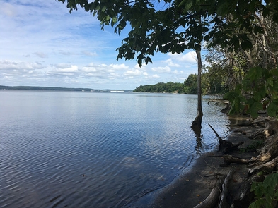
The Douglas Point Area lies in a lightly populated area of southern Maryland in western Charles County. The remaining portions of this once agricultural and rural peninsula county are experiencing rapid growth due to expanding economic opportunities created by increased military and contractor presence and urban sprawl. On December 21, 2001, BLM and the State of Maryland jointly acquired about 1,270 acres of land known as Douglas Point, lying along the Potomac River in Charles County. This area, one of the last remaining undeveloped tracts along the Potomac River, near fast-growing Washington, DC, offers outstanding potential for recreation, wildlife habitat, and cultural resources. The Douglas Point tract contains magnificent hardwood forests. Other unique resources in the general vicinity include the site of a Civil War encampment of approximately 25,000 troops; and archeological sites, habitat for a wide variety of terrestrial and aquatic species, unique wetlands and woodlands, and the evolving ecosystems of the shipwrecks at Mallow Bay.
RecAreaDirections
From Interstate Highway 95/495 in Maryland, take Exit 3 for Hwy 210 South to Hwy 225, connecting with Hwy 224. Follow signs for Nanjemoy and the Purse State Park.
Open with Google MapMisc
| Stay Limit | |
| Reservable | false |
| Keywords | |
| Map Link | |
| Contact Phone | |
| Contact Email |
Permits info
Facilities
Star-Spangled Banner National Historic Trail Facility
The Star-Spangled Banner National Historic Trail commemorates the Chesapeake Campaign of the War of 1812 and gets its name from our national anthem. Consisting of water and overland routes, the trail extends from Virginia, through southern Maryland closely following the shores of the Chesapeake Bay. As this trail passes by the shoreline of Douglas Point Special Recreation Management Area in Charles County, Maryland, it follows the War of 1812 route of the British fleet, which chocked Washington, D.C. with shipping blockades and whose sailors ravaged the coastline of the Chesapeake Bay with frequent raids. This trail commemorates the people, events, and naval history, which inspired our national anthem. A water stop at Blue Bay provides access to the historic Chiles home site managed by the BLM in partnership with the National Park Service. There are picnic facilities at Blue Bay, which is also a trailhead for the Potomac Heritage National Scenic Trail as it crosses Douglas Point.
Captain John Smith Chesapeake National Historic Trail Facility
National Historic Trails closely follow a historic trail or route of travel of national significance. This designation, authorized by Congress, identifies, and protects historic routes, historic remnants, and artifacts for public use and enjoyment. The Captain John Smith Chesapeake National Historic Trail is a series of water routes extending approximately 3,000 miles along the Chesapeake Bay, the nation's largest estuary. These historic routes trace the 1607 to 1609 voyages of Captain John Smith as he charted the land and waterways of the Chesapeake. It meanders along the shoreline of Douglas Point, Maryland, where the BLM manages the historic 18th century Chiles home site in partnership with the National Park Service. Paddlers may rest at the Blue Bay water stop and enjoy picnic facilities. This stop also provides access to the Chiles site, and is a trailhead for the Potomac Heritage National Scenic Trail as it crosses Douglas Point.
