
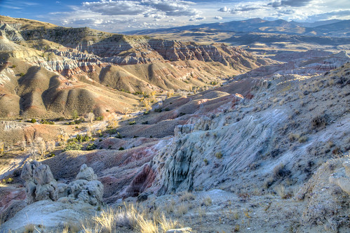
Dubois Badlands
The Dubois Badlands WSA encompasses 4,520 acres of BLM-administered land with no split estate or private inholdings. The topography of the area is primarily badlands and flat topped benches, which are extensively eroded and separated by numerous and intricate drainage patterns. Bands of red and tan sedimentary rock and clays make interesting color patters through the area.
Opportunities for primitive and unconfined recreation in the Dubois Badlands WSA are limited and lack outstanding characteristics. Day hiking would be possible, but the WSA's size and lack of water limits its attraction for extended backpacking. While some primitive recreation activities are clearly possible in the WSA, the limited number and scope of such activities result in less than outstanding opportunities for primitive and unconfined recreation.
The Dubois Badlands WSA contains several special features. The area's relatively unique geology and its scenery are major attractions.
RecAreaDirections
Access to wild lands inherently requires navigational skills and requires four wheel-drive/high clearance vehicles. Visitors should be prepared for adverse weather and road conditions. The WSAs in the Lander Field Office are primarily accessed by unnamed/unsigned two track roads; in many cases, these roads are impossible to find without good navigational skills and equipment. You will need to use your navigational skills to access the Dubois Badlands WSA from the Dubois dump road.
Open with Google MapMisc
| Stay Limit | |
| Reservable | false |
| Keywords | |
| Map Link | |
| Contact Phone | |
| Contact Email |
Permits info
Facilities
no data available
