
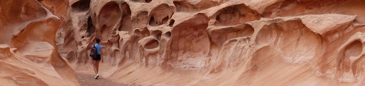
Crack Canyon
The wilderness study area (WSA) includes popular hikes such as Little Wild Horse and Bell Canyons, Ding and Dang Canyon, and Crack and Chute Canyons.
The WSA landscape has colorful badlands of eroded soils, cliffs, and rock monuments, including fins which form a sawtooth sandstone ridge, and knobs, caves, and arches. Canyons from 200 to 500 feet deep cross the Reef and the WSA, narrowing in places to clefts with bottoms constantly in shadow. Small pictograph or petroglyph panels exist in the canyons. Considerable evidence of old mining activity surrounds the north, west, and south boundaries of the WSA. Shacks, cabins, and mine shafts adjacent to the WSA provide striking contrast to the color, beauty, and magnitude of the WSA and surrounding land.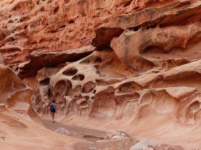
RecAreaDirections
Crack Canyon WSA is located in Emery County, about 15 miles north of Hanksville, UT and directly west of Goblin Valley State Park.
Open with Google MapMisc
| Stay Limit | |
| Reservable | false |
| Keywords | |
| Map Link | |
| Contact Phone | |
| Contact Email |
Permits info
Facilities
Ding and Dang Trailhead Facility
Ding and Dang is a technical slot canyon hike located within the Muddy Creek Wilderness Area. Hikers should be experienced and rope is recommended. This hike is a 5 mile round trip and will take 3 to 4 hours to complete. The suggested route is to climb Ding Canyon and descend Dang Canyon. The trailhead offers parking but no overnight camping. The canyons have extreme potential for flash floods please use extreme caution and pay attention to the weather.
Little Wild Horse Trailhead Facility
Little Wild Horse and Bell Canyons is one of the most popular slot canyons in Utah. Little Wild Horse and Bell Canyons are within the Muddy Creek Wilderness in Emery County, Utah. Visitors can explore the canyons on a eight mile loop trail and will take close to four hours to complete. Please check the weather before visiting Little Wild Horse Canyon and avoid the area if there is potential for rain. The canyons have extreme potential for flash floods. Visitors should use caution when planning a trip to the area.
Crack Canyon Trailhead Facility
Crack Canyon is one of the many slot canyons in the Muddy Creek Wilderness Area. This hike can be accessed by the Behind the Reef Road. The canyon has three sections on narrows that can be completed by experiences hikers and is often combined with Chute Canyon to form a loop. Spring and Fall are ideal times to hike these canyons. Always be aware of the extreme flash flood potential.
Chute Canyon Trailhead Facility
Chute Canyon is one of the many slot canyons in the Muddy Creek Wilderness Area. This hike can be accessed by the Behind the Reef Road. The canyon has three sections on narrows that can be completed by experiences hikers and is often combined with Chute Canyon to form a loop. Spring and Fall are ideal times to hike these canyons. Always be aware of the extreme flash flood potential.
Behind the Reef Trail Facility
One of the BLM’s highlighted OHV/ATV trails within the San Rafael Swell this area provides a challenging off highway adventure and launching point for a variety of recreation activities. Jeepers, UTV’s, ATV’s, Mountain Bikes and hikers can all find their niche in this area. The main Behind the Reef trail turns into a 52 inch or less trail that exits around the Hidden Splendor Mine area while other routes provide recreational opportunities for all types of user groups. Please plan ahead this trail is difficult in rating and is located in a remote location with limited cell service available. Dispersed camping and hiking opportunities can be found throughout this area. The Behind the Reef trailhead is located on the west side of the San Rafael Reef. From Hwy 24, turn onto the Goblin Valley/Temple Mountain Road. Instead of turning down to Goblin Valley, continue west through the Reef. As you come out on the west side of the Reef you'll see a well maintained road heading south marked as the Behind the Reef Road. Drive south on that road approximately 6 miles to the trailhead parking area, kiosk and registry box.
