
Crooked Wild and Scenic River
Overview:
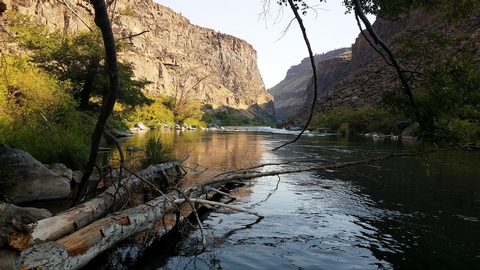
Central Oregon's Crooked Wild and Scenic River flows from the forested heights of the Ochoco Mountains to the high desert near Lake Billy Chinook at its confluence with the Deschutes River. The wild and scenic portion of the Crooked river spans 61 miles in three reaches: the North Fork, the Chimney Rock segment and the Lower Crooked River.Know Before You Go:
- Nine non-reservable campgrounds and two day-use areas provide easy year-round access to the Chimney Rock segment south of Prineville, Oregon.
- Fires are prohibited annually from June 1 through October 15 in the Lower Crooked River segment.
- Accessible fishing platforms are available at Palisades and Chimney Rock campgrounds.
- A seasonally-open gate at Telephone Springs limits motorized access to the North Fork of the Crooked River annually from April 30 through December 1.
Point of Interest:
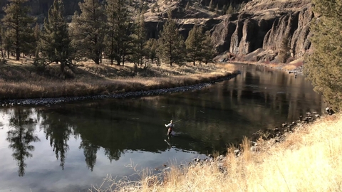
A world-class fishery is located below Bowman Dam along the Chimney Rock segment. Fly fishers enjoy plenty of easy access along the adjacent Crooked River Back Country Byway.For a different view, visitors can ride the 18-mile Crooked River Canyon Scenic Bikeway from Prineville to Big Bend Campground. Designated in 2018, this moderate route takes riders from picturesque farms to towering cliffs.
RecAreaDirections
North Fork: From Prineville, Oregon, drive southeast for 35 miles on the Post-Paulina Highway (OR 380). Turn left on Teaters Road and proceed 1.4 miles to an unnamed gravel road on the left. Drive approximately 6.2 miles to the seasonal gate at Telephone Springs. From here, you can park and hike or take one of the rough spur ways towards the river.
Chimney Rock Segment: From Prineville, Oregon, drive 12 miles south on the Crooked River Highway (OR 27). The wild and scenic segment begins here and continues south 7.3 miles to Bowman Dam.
Lower Crooked River: From Terrebonne, Oregon, drive 0.5 miles north on The Dalles-California Highway (US97). Turn left onto NW Lower Bridge Way/Lower Bridge Market Rd for 2.2 miles. Turn right onto NW 43rd St and drive 1.8 miles. Turn left onto NW Chinook Drive and proceed for 5.1 miles. Then NW Chinook Dr turns slightly right and becomes SW Horny Hollow Trail; drive another 1.8 miles and continue straight to stay on SW Horny Hollow Trail. The Otter Bench Trailhead offers several access trails to the river.
Open with Google MapMisc
| Stay Limit | 14 Days |
| Reservable | false |
| Keywords | |
| Map Link | |
| Contact Phone | |
| Contact Email |
Permits info
Facilities
Castle Rock Campground Campground
List of CampsitesLocated south of Prineville, Oregon, this six-site campground offers year-round camping and Crooked River access along the Lower Crooked Back Country Byway. Castle Rock looms above its namesake campground on the Chimney Rock section of the Crooked WIld and Scenic River. An ADA-accessible vault toilet is onsite.
Know Before You Go:
- Open year-round on a first-come, first-served basis; no potable water available.
- Cell phone service is not available in the campground.
- Watch for bicyclists: the section of State Highway 27 between Prineville and Bowman dam is a state scenic bikeway
Point of Interest:
Castle Rock Campground is the first in a series of twelve Bureau of Land Management recreation sites along the Crooked Wild and Scenic River, south of Prineville, Oregon. Eight additional campgrounds, two day-use areas and a trailhead offer ample access to camping, fishing, hiking and photography.
Stillwater Campground Campground
List of CampsitesStillwater Campground offers ten large, partially-shaded campsites along a placid stretch of the Lower Crooked Wild and Scenic River. Some pull-through campsites as well as day-use parking are available in the recreation site.
Know Before You Go:
- Open year-round on a first-come, first-served basis; no potable water is available.
- Cell phone service is not available in the campground.
- When recreating on public lands, practice Leave-No-Trace Principles.
- Watch for bicyclists: the section of road between Prineville and Bowman Dam is a state scenic bikeway
Point of Interest:
The Chimney Rock segment of the Crooked River is characterized by a mostly steady gradient in the wild and scenic segment. Stillwater Campground is situated along one of the quiet locations of flatwater alluding to its name.
Palisades Campground Facility
Unlike most of the other campgrounds along the Crooked River, this 14.5-acre campground is set back some from the Lower Crooked Back Country Byway, providing some isolation. Campground facilities include fourteen mostly broad, spacious campsites, vault toilets and an accessible fishing pier. All but one of the campsites are at river level and accessed by a single-lane road.
Know Before You Go:
- Open year-round on a first-come, first-served basis. No reservations are accepted.
- Potable water is available year-round at the upriver Chimney Rock Campground, 0.8 miles north on State HIghway 27.
- Cell phone service is not available in the campground.
- Watch for bicyclists: the section of State Highway 27 between Prineville and Bowman Dam is designated as the Crooked River Canyon Scenic Bikeway.
Point of Interest:
The site takes its name from nearby rock outcrops composed of basaltic lava which form the steep, formidable cliff faces across the river from the campground.Lone Pine Campground Facility
Centered around a single, sentinel Ponderosa Pine tree, this small campground features six campsites and a group use area. Across the Crooked River, the photogenic Rocky Canyon and it’s vertical rimrock cliffs offer photographers a variety of ever-changing light and depth perspectives.
Know Before You Go:
- Open year-round on a first-come, first-served basis. No reservations are accepted.
- Potable water is available year-round at Chimney Rock Campground, 1.7 miles miles west (upriver) on State HIghway 27.
- Cell phone service is not available in the campground.
- Watch for bicyclists: the section of State Highway 27 between Prineville and Bowman Dam is designated as the Crooked River Canyon Scenic Bikeway.
Point of Interest:
Since 2008, reintroduction of Steelhead trout has been underway in the Deschutes River Basin, which includes the wild and scenic Chimney Rock segment of the Crooked River. The success of this reintroduction is in part dependent on stresses placed on this fish. Anglers should keep them in the water and release them immediately; the harvesting of Steelhead in the Crooked River is unlawful.Poison Butte Campground Facility
This cozy and compact campground offers year-round camping and Crooked Wild and Scenic River access along the Lower Crooked Back Country Byway. Campground facilities include 5 campsites, day-use parking with access to the Crooked Wild and Scenic River.
Know Before You Go:
- Open year-round on a first-come, first-served basis. No reservations are accepted.
- Potable water is available during the warmer spring and summer months at the nearby Big Bend Campground, 0.9 miles south on State HIghway 27.
- Cell phone service is not available in the campground.
- Watch for bicyclists: the section of State Highway 27 between Prineville and Bowman Dam is designated as the Crooked River Canyon Scenic Bikeway.
Point of Interest:
Hike the short riverside trail to the single, old growth Ponderosa pine tree, a relative rarity in the Crooked River canyon.Post Pile Campground Facility
With views of nearby Chimney Rock, this campground offers year-round camping and Crooked River access along the Lower Crooked Back Country Byway. Campground facilities include seven campsites with excellent access to the Crooked Wild and Scenic River.
Know Before You Go:
- Open year-round on a first-come, first-served basis. No reservations are accepted.
- Potable water is available year-round at the nearby Chimney Rock Campground, 1.3 miles north on State Highway 27.
- Cell phone service is not available in the campground.
- Watch for bicyclists: the section of State Highway 27 between Prineville and Bowman Dam is designated as the Crooked River Canyon Scenic Bikeway.
Point of Interest:
The campground takes its name from nearby rock outcrops composed of basaltic lava. As these formations cooled, a multi-sided joint pattern formed which seemingly resulted in the appearance of a pile of posts stacked vertically. The geologic phenomena is known as columnar basalt.Big Bend Campground Facility
Located south of Prineville, Oregon, this campground offers year-round camping and Crooked Wild and Scenic River access along the Lower Crooked Back Country Byway. Cooperatively managed in partnership with the Bureau of Reclamation and Oregon Parks and Recreation Department, this campground's facilities include 13 campsites, one group use area and a day-use area with access to the Crooked Wild and Scenic River.
Know Before You Go:
- Open year-round on a first-come, first-served basis. No reservations are accepted.
- Potable water is available during the warmer spring and summer months.
- Cell phone service is not available in the campground.
- Watch for bicyclists: the section of State Highway 27 between Prineville and Bowman Dam is designated as the Crooked River Canyon Scenic Bikeway.
Point of Interest:
Looming 240 feet above the campground, the mighty Arthur R. Bowman Dam retains the waters of the 3,030-acre Prineville Reservoir, a popular spot for fishing and other water-based activities. At 1.6 miles away from Big Bend Campground, the boat ramp at Powderhouse Cove provides the nearest reservoir access.Greenwood Day-Use Area Facility
This small parking area has trails leading both up and down river providing plenty of angling access. Or, one can make use of the provided bench or step right down to the bank of the Crooked Wild and Scenic River.
Know Before You Go:
- Open year-round for day-use only.
- Potable water is available year-round at Chimney Rock Campground, 2.1 miles miles west (upriver) on State Highway 27.
- Cell phone service is not available at the site.
- Watch for bicyclists: the section of State Highway 27 between Prineville and Bowman Dam is designated as the Crooked River Canyon Scenic Bikeway.
Point of Interest:
The views from this straight stretch of the Crooked River are dominated by near vertical cliff walls; photographers favor the site during the hours when low-angle lighting highlight the brilliant textures of the basaltic lava flows high above the river.
Upper Lone Pine Day-Use Area Facility
Situated just next to Lone Pine Campground, this small day-use area offers easy access to the Crooked Wild and Scenic River with trails both up and downriver of the site. Picnic tables and a vault toilet are available at the site.
Know Before You Go:
- Open year-round for day-use only.
- Potable water is available year-round at Chimney Rock Campground, 1.6 miles miles west (upriver) on State Highway 27.
- Cell phone service is not available at the site.
- Watch for bicyclists: the section of State Highway 27 between Prineville and Bowman Dam is designated as the Crooked River Canyon Scenic Bikeway.
Point of Interest:
Upper Lone Pine Day-Use Area is one of two fee-free day-use areas within the Chimney Rock segment of the Crooked River WIld and Scenic River corridor. Enjoy picnicking, fly-fishing and photography at the site.Chimney Rock Trail Facility
Take a break from your scenic drive along the Lower Crooked Wild and Scenic River south of Prineville and hike one of the gems of the High Desert. Walk in the shadows of lichen-covered basalt cliffs as you zigzag up and out of the river canyon to spectacular views of Central Oregon. The trek is about 1.3 miles and ends at the namesake chimney basalt rock formation. Pause on one of the benches along the way for a drink of water and just absorb the beauty of the area before heading back to your car and the rest of your travels.
Know Before You Go:
- Open YEAR ROUND but really nice in the spring or fall when a little moisture has tamped down the dust.
- Accessibility out and back trail, 2.6 miles round trip and a little steep at points.
- Amenities The trail is near Chimney Rock campground, with toilets and potable water near campsite 8.
- Pets are allowed but should on leash -- and please pack out any waste!
Point of Interest:
This part of the Lower Crooked River has 9 campgrounds and 2 day-use areas. Come for the hike and stay for some wildlife viewing, fly-fishing, and camping!Chimney Rock Brochure
360° from top of the Chimney Rock Trail
Chimney Rock Campground Campground
List of CampsitesAlong the Chimney Rock segment of Central Oregon's Crooked Wild and Scenic River, Chimney Rock campground offers a relaxing woodland setting amongst Western Juniper trees and beneath massive Columbia River rock formations. Fly-fishing and hiking on the nearby Chimney Rock trail offer day-long recreational fun. Enjoy plenty of easy river access along the adjacent Crooked River Back Country Byway, State Highway 27.
Know Before You Go:
- Chimney Rock Campground is open year-round and is equipped with 16 campsites and vault toilets. No reservations are accepted; site is first-come, first-served only.
- Water is available in the campground and an accessible fishing platform is located near the campground entrance.
- When recreating on public lands, practice Leave-No-Trace Principles.
- Don't Move Firewood: Please protect Pacific Northwest forests by preventing the spread of invasive species. Firewood can carry insects and diseases that can threaten the health of our western forests. You can make a difference by obtaining and burning your firewood near your camping destination.
Point of Interest:
Check out the campground's namesake butte located prominently above highway 27 opposite the campground. Access to the trailhead is across the highway at the Chimney Rock Trailhead.For a different view, visitors can ride the 18-mile Crooked River Canyon Scenic Bikeway from Prineville to Big Bend Campground. Designated in 2018, this moderate route takes riders from picturesque farms to towering cliffs.
