
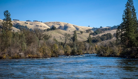
South Fork American River
Remember your OUTDOOR ETHICS when enjoying your public lands. Please RECREATE RESPONSIBLY.
There is NO DISPERSED CAMPING ON PUBLIC LANDS along the South Fork American River.
Overview
The South Fork of the American River is considered to be one of the finest recreational resources in California. The river's rapids are relatively gentle and the countryside is rich in history. Opportunities for a wide variety of outdoor activities include whitewater rafting & kayaking, picnicking, trail hiking, horseback riding, bicycling, hunting, fishing, gold panning, wildlife viewing and other passive recreation. All of them unique ways to experience the habitat and beauty of the South Fork of the American River.
Recreation Sites:
- Cronan Ranch Trailhead
- Magnolia Ranch Trailhead
- Greenwood Creek River Access
- Dave Moore Nature Area
- Old Flume Trail Trailhead
Special Recreation Permits
- Permit Application (2930-1)
Need a Map?
South Fork American River General Map
Please read about Hiking on Public Lands
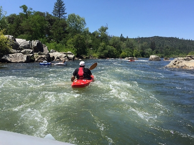
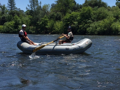
The South Fork American is one of the most popular (and most populated) whitewater river runs for rafting and kayaking in the state. The river offers short shuttles between access points, several trip options, high spring flows, and dependable boating flows during the summer months when other rivers have dropped too low. This twenty-one (21) mile river run can be made in a full day or a more relaxing two day trip for both beginning and intermediate boaters.
Put-In: Chili Bar, Henningsen-Lotus Park, Highway 49 Bridge West, Marshall Gold Discovery State Historical Park, Camp Lotus, Greenwood Creek.
Take-Out: Henningsen-Lotus Park, Greenwood Creek, Salmon Falls Bridge.
Please note: If you are not an experienced rafter, we suggest you make your trip with one of the BLM-permitted commercial companies who operate on the river. All permitted operators must meet strict standards for safety and quality of service.
History
The South Fork American also has a special significance because of the river's role in the Great California Gold Rush of 1849. In the town of Coloma and along the river is the site of James Marshall's discovery of gold at Sutter's Mill on January 24, 1848.
Be sure to come to shore long enough to visit and enjoy the Marshall Gold Discovery State Historic Park.
And for more information, please also check out the Gold Discovery Park Association.
Helpful Links:
- Be Bear Aware (USFS webpage)
- Keep Me Wild: Mountain Lion (CDFW webpage)
- Dreamflows Home Page (River flow info courtesy of Chris Shackleton, Sacramento, CA)
Return To: BLM, Mother Lode Field Office
RecAreaDirections
The South Fork American River can be accessed at many points from Highway 49. Please see our South Fork American River General Map.
Open with Google MapMisc
| Stay Limit | |
| Reservable | false |
| Keywords | |
| Map Link | |
| Contact Phone | |
| Contact Email |
Permits info
Facilities
Cronan Ranch Trailhead Facility
Remember your OUTDOOR ETHICS when enjoying your public lands. Please RECREATE RESPONSIBLY.
Overview
Cronan Ranch Trailhead is located in Pilot Hill, California. The area contains 12 miles of trails for hiking, biking, horseback riding, fishing, bird watching and other passive recreation. There is a wide variety of terrain to choose from, including gently sloped to challenging hills, oak woodland and gentle riverfront trails. Each season offers a diverse experience.
The land for Cronan Ranch and river trail corridor was purchased by the American River Conservancy, BLM and other partners over a period of 16 years and placed into public trust to be used for recreation and wildlife conservation. The purchase was made possible through generous donations by individuals, private foundations and government agencies, including the Wildlife Conservation Board and the California State Resources Agency.
Cronan Ranch connects with the South Fork American River corridor trail that runs from Greenwood Creek to Salmon Falls. For more information, see our South Fork American River webpage.
What you need to know:
- Cronan Ranch is a Day-Use area only. No overnight camping.
- Only non-motorized recreational activities such as hiking, mountain biking, horseback riding and other similar passive activities are allowed.
- Portions of this trail system border private property. Please respect the rights of private property owners by staying on designated routes at all times.
- Please be aware that there are mountain lions and rattlesnakes in the area.
- Fireworks are prohibited.
- Fuelwood cutting and collection is prohibited.
- A Special Recreation Use Permit is required for all commercial, organized groups, or competitive activities.
Helpful Links:
Hunting and Shooting Info - Cronan Ranch:
Firearms: The discharge of firearms is prohibited except in the course of licensed, in-season hunting activities. Hunting with rifles is prohibited within the Cronan Ranch Management Area during any season. Hunting weapons limited to bow and arrows, smooth bore shotguns and muzzleloaders. Muzzleloaders allowed only after fire season is declared over.
- No target shooting allowed.
- No hunting for bear, squirrels, rabbits, jackrabbits, waterfowl, furbearers, or non game species.
- Quail and Dove hunting during correct season.
- Deer hunting: Fall season - smooth bore shotgun and slugs only.
- Deer hunting: Summer season - bow & arrows only.
- Turkey hunting: Fall season - bow & arrows, smooth bore shotgun and shot shells only.
- Turkey hunting: No SPRING SEASON turkey hunting.
NOTE: All California game species are regulated by the California Department of Fish and Wildlife (CDFW).Rules, regulations, and seasons are controlled by CDFW, and it is the hunter's responsibility to verify and comply with proper species, seasons, zones, regulations, and legal location if hunting on public lands.
FGC 3004 — It is unlawful for any person to hunt or discharge while hunting, any firearm or other deadly weapon within 150 yards of any occupied dwelling house, residence, or other building or any barn or other outbuilding used in connection therewith. The 150 yard area is a "Safety Zone."
More Helpful Links:
- Where to Shoot
- California Department of Fish & Wildlife
- Hunting, Fishing and Recreational Shooting on Public Lands, BLM California
Other BLM Trailheads:
Return To: BLM, Mother Lode Field Office
Dave Moore Nature Area Facility
Remember your OUTDOOR ETHICS when enjoying your public lands. Please RECREATE RESPONSIBLY.
What you need to know:
- Dave Moore Nature Area is a Day-Use area only. No overnight camping.
- No equestrian use on trail.
- CLOSED to all hunting and target shooting.
- Potable water is not available. Bring your own water.
- Please be aware that there are bobcats and rattlesnakes in the area.
- Fireworks are prohibited.
- Firewood cutting and collection is prohibited.
- A Special Recreation Use Permit is required for all commercial, organized groups, or competitive activities.
- Hiking on Public Lands
Overview
One of the main features of the BLM, Dave Moore Nature Area is a loop trail about a mile long which goes from the parking lot trail head to the South Fork American River and back again passing through several habitat types. Nestled in the heart of Gold Rush Country, the trail is lined with remnants from nearly 150 years ago when Chinese laborers channeled creek water by hand with pick and shovel for gold mining. Tailing piles from the Gold Rush period blanket the area which lend to the characteristic landscape that makes this area so unique.
As you travel along the Dave Moore Nature Trail you will encounter several natural features - most interesting is "Mushroom Rock" - two stacked granite boulders with a softer layer of decomposed granite in between that has been weathered by the river of the past. Look for the tall Ponderosa pine trees too big in diameter to put your arms around. And the majestic California Madrone tree in all it's awesome beauty is worth a stop to feel it's cooling smooth bark. Throughout the trail are hand made walls of lichen and moss covered rocks which guide your way to the South Fork American River -- your destination easily reached within a half mile from the parking lot trailhead.
After you explore the cooling rivers edge, you can return along the trail the same way you came or choose to take the lower loop back up to the parking area. Within the half mile loop back you travel thru shaded riparian habitat and oak woodland. You will encounter large Incense cedar trees towering above you, gigantic granite boulders three times your height in amazing configurations and sizes, and beautiful native wildflowers, shrubs and trees of the local area. Listen as birds call out to alert your presence on the trail. Enjoy being surprised by the lizard in the grass scurrying across to greet you. And see if you can find what little treasures have been left behind....
Please read about Hiking on Public Lands
History
David Moore was born June 4, 1949 in Memphis, Tennessee and died August 13, 2001 in Calistoga, California. He graduated from Calistoga High School in 1967. After graduation, he entered the Navy and served for a term of four years, then attended Humboldt State University where he graduated in 1975. For the next ten years, Moore was employed by the Bureau of Land Management as a Conservation Ranger. He was stricken with multiple sclerosis at age 35 and forced to retire in 1987.
David Moore was an avid outdoorsman who loved to hunt, fish, whitewater raft, and golf. His disability brought to his co-workers such an awareness of the challenge faced by disabled persons that they developed a Nature Area along the South Fork of the American River near Coloma, California.
On June 4, 1994, National Trails Day and Moore's 46 birthday, the staff of the BLM Folsom Resource Area (aka Mother Lode Field Office) held a grand opening of the Nature Area, and dedicated it as the Dave Moore Nature Area.
A special thanks to Captain Frank Clark and his crew from the Growlsburg Conservation Camp and all the other individuals and groups who made this Nature Area possible. We are sincerely grateful.
Also VISIT: South Fork American River webpage
Other BLM Trailheads:
Return To: BLM, Mother Lode Field Office
Greenwood Creek River Access Facility
Remember your OUTDOOR ETHICS when enjoying your public lands. Please RECREATE RESPONSIBLY.
Overview
The BLM, Greenwood Creek River Access location provides access to the South Fork of the American River. It serves as a take-out for the Coloma to Greenwood or "C to G" run and as a put-in for the lower Class III run of the South Fork American River. Greenwood Creek River Access has limited parking at this time. There is no fee for use and is available for non-commercial river access.
Greenwood Creek River Access has overflow parking at the Magnolia Ranch Trailhead parking lot. A trail connects you back to the Greenwood Creek River Access.
What you need to know:
- Greenwood Creek River Access is a Day-Use area only. No overnight camping.
- Portions of this trail system border private property. Please respect the rights of private property owners by staying on designated routes at all times.
- Please be aware that there are mountain lions and rattlesnakes in the area.
- Fireworks are prohibited.
- Fuelwood cutting and collection is prohibited.
- A Special Recreation Use Permit is required for all commercial, organized groups, or competitive activities.
- Pack it in - pack it out... and pack a little extra if you can. Help us keep this area clean.
Hunting and Shooting Info - Greenwood Creek River Access:
- No target shooting allowed
- No hunting for bear, squirrels, rabbits, jackrabbits, waterfowl, furbearers, or non game species
NOTE: All California game species are regulated by the California Department of Fish and Wildlife (CDFW). Rules, regulations, and seasons are controlled by CDFW, and it is the hunter's responsibility to verify and comply with proper species, seasons, zones, regulations, and legal location if hunting on public lands.
FGC 3004 — It is unlawful for any person to hunt or discharge while hunting, any firearm or other deadly weapon within 150 yards of any occupied dwelling house, residence, or other building or any barn or other outbuilding used in connection therewith. The 150 yard area is a "Safety Zone."
Helpful Links:
- Where to Shoot
- California Department of Fish & Wildlife
- Hunting, Fishing and Recreational Shooting on Public Lands, BLM California
Also VISIT: South Fork American River webpage.
Other BLM Trailheads:
Return To: BLM, Mother Lode Field Office
Magnolia Ranch Trailhead Facility
Remember your OUTDOOR ETHICS when enjoying your public lands. Please RECREATE RESPONSIBLY.
Overview
The BLM, Magnolia Ranch Trailhead is located approximately five (5) miles north of the town of Coloma along Highway 49 and the South Fork of the American River. It is situated between the Cronan Ranch Regional Trails Park and Greenwood Creek River Access on public lands.
The Magnolia Ranch Trailhead takes you along the 2.5 mile Gerle Loop Trail which is an easy to moderate, mostly flat trail across rolling hills and oak woodlands with scenic views and access to the American River. The Gerle Loop trail ties into a more extensive trail system west of Hastings Creek and leads you into the Cronan Ranch Regional Trails Park.
What you need to know:
- Magnolia Ranch is a Day-Use area only. No overnight camping.
- Only non-motorized recreational activities such as hiking, mountain biking, horseback riding and other similar passive activities are allowed.
- Portions of this trail system border private property. Please respect the rights of private property owners by staying on designated routes at all times.
- Please be aware that there are mountain lions and rattlesnakes in the area.
- Fireworks are prohibited.
- Fuelwood cutting and collection is prohibited.
- A Special Recreation Use Permit is required for all commercial, organized groups, or competitive activities.
Helpful Links:
Pack it in - pack it out... and pack a little extra if you can. Help us keep this area clean.
Hunting and Shooting Info - Magnolia Ranch:
- No target shooting allowed
- No hunting for bear, squirrels, rabbits, jackrabbits, waterfowl, furbearers, or non game species
NOTE: All California game species are regulated by the California Department of Fish and Wildlife (CDFW). Rules, regulations, and seasons are controlled by CDFW, and it is the hunter's responsibility to verify and comply with proper species, seasons, zones, regulations, and legal location if hunting on public lands.
FGC 3004 — It is unlawful for any person to hunt or discharge while hunting, any firearm or other deadly weapon within 150 yards of any occupied dwelling house, residence, or other building or any barn or other outbuilding used in connection therewith. The 150 yard area is a "Safety Zone."
More Helpful Links:
- Where to Shoot
- California Department of Fish & Wildlife
- Hunting, Fishing and Recreational Shooting on Public Lands, BLM California
Also VISIT: South Fork American River webpage
Other BLM Trailheads:
Return To: BLM, Mother Lode Field Office
Old Flume Trail Trailhead Facility
Remember your OUTDOOR ETHICS when enjoying your public lands. Please RECREATE RESPONSIBLY.
Overview
Between the towns of Placerville and Coloma along Highway 49, the Old Flume Trail offers access to the South Fork of the American River. The trail is wide and the terrain is not technically difficult as it heads down into the canyon from the parking lot. But the trail does drops rather steeply down an old existing road -- about 800 feet in less than a mile and leads to a quiet location just below Racehouse Bend rapid on the South Fork.
Please note: It may only take you a half hour to get down the trail, but be prepared for a steep and much longer walk back up. Give yourself a couple hours and take plenty of water.
What you need to know:
- Old Flume Trail is a Day-Use area only. No overnight camping.
- Closed to all hunting and target shooting.
- Please avoid parking outside the fence along the roadway.
- Portions of this trail system border private property. Please respect the rights of private property owners by staying on designated routes at all times.
- Fireworks are prohibited.
- Fuelwood cutting and collection is prohibited.
Helpful Links:
History
The Old Flume Trail crosses over a historic ditch which carried water from Chili Bar ten miles downstream to the town of Lotus. This flume was one of the largest ever built in El Dorado County at 153' high and 750' long. The property is now managed by the BLM after the American River Conservancy (ARC) acquired a land grant from Richard and Arlene Wilkinson in 1991.
Also VISIT: South Fork American River webpage
Return To: BLM, Mother Lode Field Office
