
North Fork American River
Remember your OUTDOOR ETHICS when enjoying your public lands. Please RECREATE RESPONSIBLY.
Overview
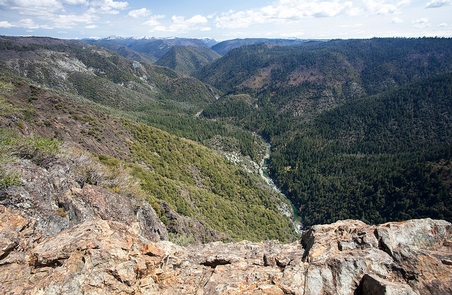
The North Fork American River lies within a deeply incised canyon with the river itself being 2,000 feet to 2,400 feet below the canyon rim. This segment of the river is a Congressionally-designated Wild River and a State-designated Wild Trout Stream. Features include scenic, recreation, cultural and water quality values. Ponderosa pine forest occupies much of the area with some steep hillsides occupied by oak woodland and chaparral. Historical features along the North Fork include the Stevens Trail, American View, and Cape Horn.
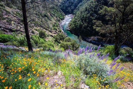
Visitors to the North Fork enjoy a semi-wilderness setting. River access is possible at the lower end near the Colfax-Iowa Hill bridge, or by a strenuous descent by trail from a few locations along the canyon rim. Trails leading to the North Fork are used by hikers, backpackers, pack and saddle stock users, gold panners, and by whitewater recreationists gaining access to the river at Euchre Bar. Whitewater rafting, hiking, backpacking, swimming, recreational gold panning, fishing, nature study and picnicking are among the most popular activities.
Whitewater recreation through this segment of river is Class V which means experts only, and only under certain conditions of flow. Typically, the whitewater run of the North Fork Wild River segment termed the “Giant Gap Run” is possible only during the spring and early summer.
Please note: This river is not recommended for the inexperienced boater.
Put-In: Euchre Bar - a two (2) mile walk from the trailhead
Take-Out: Iowa Hill-Colfax Bridge
River Class: IV-V
RECREATION SITE:
Hunting and Shooting Info - North Fork American River SRMA
- All public lands located in MDM, T. 15 N., R. 9 E., Sec. 26 are CLOSED to target shooting.
- Hunting is allowed, in accordance with State law, unless a specific area is signed CLOSED by the BLM.
NOTE: All California game species are regulated by the California Department of Fish and Wildlife (CDFW). Rules, regulations, and seasons are controlled by CDFW, and it is the hunter’s responsibility to verify and comply with proper species, seasons, zones, regulations, and legal location if hunting on public lands.
FGC 3004 – It is unlawful for any person to hunt or discharge while hunting, any firearm or other deadly weapon within 150 yards of any occupied dwelling house, residence, or other building or any barn or other outbuilding used in connection therewith. The 150 yard area is a "Safety Zone."
Helpful Links:
Where to Shoot
California Department of Fish & Wildlife
Hunting, Fishing and Recreational Shooting on Public Lands, BLM California
Return To: BLM, Mother Lode Field Office
RecAreaDirections
Getting there: Take the Alta exit off I-80 East, thirty miles northeast of Auburn. Turn south on Casa Loma Road to the trailhead. Put-in is a two (2) mile walk from the trailhead. To take-out, take the Canyon Way exit off I-80 at Colfax to the Colfax-Iowa Hill Road.
Open with Google MapMisc
| Stay Limit | |
| Reservable | false |
| Keywords | |
| Map Link | |
| Contact Phone | |
| Contact Email |
Permits info
Facilities
Stevens Trail Trailhead Facility
Remember your OUTDOOR ETHICS when enjoying your public lands. Please RECREATE RESPONSIBLY.
Overview
Historically, the Stevens Trail connected the town of Iowa Hill with the city of Colfax, both in Placer County, California. The current trail extends 4.5 miles along the northwestern slope of the North Fork of the American River Canyon. It begins at the trailhead in Colfax and ends at the confluence of Secret Ravine and the North Fork of the American River.
Notice:
Camping is not allowed in the parking lot at Stevens Trail. Vehicles are allowed to park overnight in the parking lot for up to 72 hours for dispersed camping along the Stevens Trail. Vehicles parked longer than 72 hours will be towed. Dispersed camping is allowed on public land for a period not to exceed 14 days.
Trail History
The story of the Stevens Trail begins with the establishment of the Gold Rush mining communities of Illinoistown and Iowa Hill, separated by the steep North Fork American River canyon. The Stevens Trail was originally surveyed under the ownership and direction of John Rutherford, an Iowa Hill miner and tanner. Rutherford soon brought in a partner, Truman A. Stevens, also a miner. Stevens was responsible for the completion and actual use of the trail during its main years of historic use, 1870-1895.
The trail was originally used as a toll path from Colfax down to Secret Ravine along the American River and then traveled up the other side to Iowa Hill which was a major metropolis during the Gold Rush period. Eventually, the use of the trail died down as did gold fever and it was all but forgotten until 1969 when a Sacramento area Boy Scout was credited with rediscovering the trail. Although the bridge connecting the two sides of the river no longer stands, the trail still provides a beautiful hike through an area that was once bustling with miners...all in search of gold! The Stevens Trail is now listed on the National Register of Historic Places.
Hunting and Shooting Info - Stevens Trail
- All public lands located in MDM, T. 15 N., R. 9 E., Sec. 26 are CLOSED to target shooting.
- Hunting is allowed, in accordance with State law, unless a specific area is signed CLOSED by the BLM.
NOTE: All California game species are regulated by the California Department of Fish and Wildlife (CDFW).
Rules, regulations, and seasons are controlled by CDFW, and it is the hunter's responsibility to verify and comply with proper species, seasons, zones, regulations, and legal location if hunting on public lands.
FGC 3004 — It is unlawful for any person to hunt or discharge while hunting, any firearm or other deadly weapon within 150 yards of any occupied dwelling house, residence, or other building or any barn or other outbuilding used in connection therewith. The 150 yard area is a "Safety Zone."
Helpful Links:
- Where to Shoot
- California Department of Fish & Wildlife
- Hunting, Fishing and Recreational Shooting on Public Lands, BLM California
- Hiking on Public Lands
Please also visit our webpage for: North Fork American River
Return To: BLM, Mother Lode Field Office
Euchre Bar Trailhead Facility
Euchre Bar is a trailhead and kayak, canoe, and raft put-in with access to the North Fork American River.
VISIT: USFS website for Euchre Bar Trail and Trailhead
