
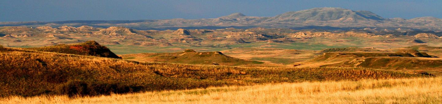
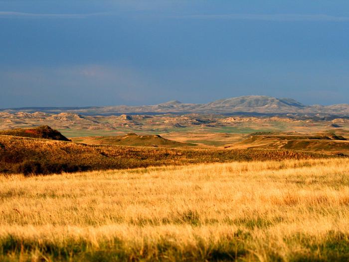
Dakota Prairie National Grasslands
Some tips to help you enjoy your recreation experience...
- Fireworks are not allowed on the Grasslands.
- Winter brings snow and extreme temperatures. Be prepared for cold weather even as early as spring, or as late as fall!
- When camping or picnicking, please keep your site clean, free from trash and food. Otherwise animals and insects are attracted to your site.
- Bag your trash and take it home with you. Help us keep our grasslands clean by "Packing It Out!"
- Never leave your campfire unattended. When you leave, put it out, dead out! See Forest Orders for any current fire restrictions
- Human waste can be a problem when recreating on the grasslands. Please see Leave No Trace - Dispose of Waste Properly for detailed instructions on handling this "delicate" situation.
Sharing the trail with horses
“What a Horse Sees!” – a short film illustrating safe ways of passing horse and rider on the trail.
Driving motorized vehicles on the Grasslands
Keep motor vehicles on designated routes and areas.
Off-Highway Vehicle:
- Driving cross-country (off a road/trail) by motorized, wheeled vehicles without a permit is generally prohibited (except for limited administrative and emergency uses) on the national grasslands for any purpose. Off-road travel is restricted in order to protect grassland resources.
- Vehicles may ONLY travel on existing roads/trails. The road/trail must be wider than the vehicle.
- Motorized travel to a campsite is allowed within 300 feet of a road/trail. Off-road travel beyond 300 feet of a road/trail to access a favorite camp sport, hunting spot, deer stand, or for any other purpose is prohibited.
- Snowmobiles are not included in the off-highway vehicle regulations. Contact your local USFS Ranger Station for specific snowmobiling rules.
- To ensure your vehicle’s undercarriage and tires aren’t carrying weed seeds, wash your vehicle before and after traveling established roads/trails.
Designated Non-Motorized Areas:
- Non-motorized restrictions are in effect for areas designated as Non-Motorized Areas on the Dakota Prairie Grasslands that prohibits any motorized use, including snowmobiles (except for limited administrative and emergency use). These areas are posted with signs and are marked on the grasslands maps that are available for purchase at each Ranger Station.
Contact your local USFS Ranger Station for more information
Where do recreation fees go and how are they used?
Recreation fees support the Grasslands ability to continue providing high levels of service to visitors at popular recreation sites. The Grasslands have made major investments to several sites such as water system upgrades, road improvements, new toilet buildings and accessible picnic tables, fire rings, and pathways. Reasonable fees paid by users of these sites and services help ensure that the Grasslands can continue maintaining and improving the sites for future generations.
With your help, we can protect our natural resources for future generations. Thank you!
RecAreaDirections
Open with Google Map
Misc
| Stay Limit | |
| Reservable | false |
| Keywords | |
| Map Link | |
| Contact Phone | |
| Contact Email |
Permits info
Facilities
CCC Campground (ND) Campground
List of CampsitesOverview
CCC Campground lies in the Badlands of North Dakota. There are a few trials located here.
There are 32 sites and 3 campground loops. The campground has 5 reservable sites.
This is a pay and scan facility. Ensure that you have Receration.gov app downloaded on your phone prior to arriving. Scan QR code to make payment. This location also excepts cash, use the fee envelopes located at the fee tubes for cash payments.
Recreation
Maah Daah Hey Trail that goes for 150 miles, Ends at Burning Coal Vein Campground. Sunset loop which is a short 2-mile hike that connects the Maah Daah Hey Trail and the Long X trail. If you are looking for a day hike, there is a 11-mile loop Maah Daah Hey Trial to the Long X Trail. Where you will see dramatic views of the badlands and prairies of Western North Dakota. The Little Missouri river runs along the northern part of the campground.
Facilities
There are 3 Vault Toilets and water is available using a hand pump. Water is available Memorial day to Labor day. This date depends on the severity of the weather. Picnic tables at each site, fire rings with grill at each site, parking pads up to 60 ft long. Horses are allowed in marked campsites
Natural Features
Here you will be surrounded by colorful buttes. During your stay you may have Prong horn, mule and white tail deer going through your site. On rare occasions Big horn sheep can be seen grazing in the area. This area is great for birders, plant enthusiast during the spring and summer months. Perfect all year for the outdoor adventurers.
Nearby Attractions
Right across the river is Theodore Roosevelt National Park. Watford City is a 15 min drive north on HWY 85 for any supplies that you may need.
Sather Lake Campground (ND) Campground
List of CampsitesOverview
Sather Lake Campground lies in the Badlands of North Dakota. There are 18 sites and 3 campground loops. The campground has no reservable sites.
Recreation
Here you will be able to boat and fish.
Facilities
There are 3 Vault Toilets and water is available using a hand pump. Water is available Memorial day to Labor day. This date depends on the severity of the weather. Picnic tables at each site, fire rings with grill at each site, parking pads up to 60 ft long.
Natural Features
During your stay you may have Prong horn, mule and white tail deer going through your site.
Nearby Attractions
Watford City is a 30 min drive East and Sidney, Montana is 30 min drive West for any supplies that you may need.
Little Missouri National Grassland Facility
Little Missouri National Grassland is located in western North Dakota, USA. At 1,033,271 acres (418,150 ha), it is the largest grassland in the country.[1] Enclaved within its borders is Theodore Roosevelt National Park, which is managed by the National Park Service (and therefore not included in the preceding statistics). The Little Missouri National Grassland was once a part of the Custer National Forest, but is now a part of the Dakota Prairie Grasslands, a National Forest unit consisting entirely of National Grasslands. A predominant feature of the grassland is colorful and beautiful badlands and rugged terrain extensively eroded by wind and water. It is a mixed grass prairie, meaning it has both long and short grass.
The boundaries of the grasslands on certain maps can be misleading. Within the boundaries of the national grassland are significant portions of state-owned and privately owned land, much of it leased by cattle ranchers for grazing. Overall, in descending order of land area, it is located in parts of McKenzie, Billings, Slope, and Golden Valley counties.
White Butte, North Dakota's highest point, is located in the extreme southeast corner of the grassland, south of the town of Amidon.
The grassland is administered by the Forest Service as part of the Dakota Prairie Grasslands from offices in Bismarck, North Dakota. There are local ranger district offices in Dickinson and Watford City.
Cedar River National Grassland Facility
Cedar River National Grassland is located in Sioux County and Grant County in southern North Dakota, United States. It has a land area of 6,717 acres (2,718 ha). The portion in Sioux County lies within the Standing Rock Indian Reservation. Within the grassland are topographic features such as level plains and rolling hills. Dry streams and some small flowing streams exist throughout the grasslands.
The grassland is administered by the Forest Service as part of the Dakota Prairie Grasslands from offices in Bismarck, North Dakota. There are local ranger district offices (shared with Grand River National Grassland) in Lemmon, South Dakota.
Initial Rock Facility
Custer's three camps are marked along the way, and at one camp on the evening of May 28, 1876, the initials of two of the privates were carved on a sandstone boulder now known as Initial Rock. This was Custer's one-way route to his demise at the Battle of the Little Bighorn.
Buffalo Gap Campground (ND) Campground
List of CampsitesOverview
Buffalo Gap campground, located in the heart of western North Dakota.
Recreation
There is a trail near by that is called the Buffalo Gap Trail, perfect for a day hike. You can also it to the Maah Daah Hey trail using the Buffalo Gap Trail for longer hikes.
Facilities
There are two flush toilet building and a building with 3 showers.
Natural Features
Here you are surrounded by colorful buttes. During your stay you may have Prong horns, Mule deer and White tail deer come through your site. This area is good for birders and plant enthusiast during the sping and summer months. Perfect for all year outdoor adventures.
Nearby Attractions
It a short drive to the small town of Medora and enterance to Theodore Roosevelt National Park.
Sheyenne National Grassland Facility
Sheyenne National Grassland is located in southeastern North Dakota, comprising 70,180 acres (28,400 ha) of public land amid 64,769 acres (26,211 ha) of privately owned land. It is characterized by sandy soils, originally deposited as the delta of an ancient river as it emptied into glacial Lake Agassiz. Since that time, wind and rain have shaped the topography into a unique landscape ranging from flat deltaic plains to choppy sand dunes.
It is the only National Grassland in the tallgrass prairie region of the United States. The grassland provides habitat for greater prairie chickens in North Dakota as well as several other sensitive species such as the Dakota skipper and Regal Fritillary. It also contains one of largest populations of the western prairie fringed orchid, which has been placed on the list of Threatened Species by the U.S. Fish and Wildlife Service. Other unique plants found on the grassland include other orchids and ferns.
The grassland is managed with prescribed grazing, fire, and mowing. These programs are all managed in cooperation with the local grazing association. Treatment of noxious weeds is also very important and is accomplished through herbicide application, biocontrol, and sheep grazing.
Recreation opportunities abound throughout the grassland. Visitors can enjoy activities such as hiking, hunting, camping, horseback riding, photography, and backpacking. See Activities section below for detailed descriptions. Some points of interest to visit while on the grassland include: Iron Springs creek, the Horseshoe Hills, Old Bridges, Owego Pioneer Cemetery, and an Old Fire Lookout Tower.
The grassland is located in eastern Ransom and western Richland counties, about 12 miles (19km) east of the city of Lisbon. The grassland is administered by the Forest Service as part of the Dakota Prairie Grasslands from the Supervisor’s office in Bismarck, North Dakota. The local Sheyenne Ranger District office is located in Lisbon, North Dakota.
Other places of interest in the vicinity of Sheyenne National Grassland include:
The town of McLeod, North Dakota. Visitors can learn about the area’s history, including some of the Grassland’s history at the McLeod Museum Complex. The museum complex includes a Presbyterian Church built in 1909, the Soo Line Depot, a homestead house built in the late 1800s, and a one-room school house which operated from 1904-2002. McLeod is located three miles south of Highway 27 on County Road 54 or 149th Avenue SE.
The Nature Conservancy operates Brown Ranch through their Sheyenne Delta office located just a few miles southwest of McLeod, ND. Some of this land is managed in conjunction with the Sheyenne National Grassland.
Explore the Seven Wonders of Ransom County.
Grand River National Grassland Facility
Grand River National Grassland is in northwestern South Dakota, USA. It is named for the Grand River. The North and South forks of the river meet in the grassland. It has a land area of 154,783 acres (241.85 sq mi, or 626.38 km²). In descending order of acreage it lies in parts of Perkins, Corson, and Ziebach counties. The portion in Corson County also lies within the Standing Rock Indian Reservation. The portion in Ziebach County also lies within the Cheyenne River Indian Reservation. The grassland is administered by the USDA-Forest Service as part of the Dakota Prairie Grasslands (DPG) from offices in Bismarck, North Dakota. There is a local Ranger District office (shared with Cedar River National Grassland) in Lemmon, South Dakota. The DPG is part of Region One of the Forest Service. The Regional Headquarters is in Missoula, Montana.
Fish Your National Forests: This site can be accessed by Access Via Motorized Travel; Fish available include: Bass, Catfish, Walleye, Panfish, Pike; Types of fishing available include: Wade, Shore, Motorized boat, Float tube, Spin, Bait, Ice;
Battle of the Badlands Interpretive Site Facility
A 1,220-acre site featuring interesting archeological, paleontological, wildlife, and geologic resources.
It is the site of the Battle of the Badlands, fought between the United States cavalry led by General Alfred Sully, and a coalition of the Lakota and Dakota Sioux native American tribes. The battle was fought on August 7-9, 1864.
In addition to a Battle of the Badlands interpretive site, the site also contains portions of the 1864 and 1876 military trails, and the 1876 Snow Camp of the Custer Expedition to the Little Bighorn battle.
It is contiguous with the Square Buttes SIA. The area also contains several uncommon plant species.
Custer Snow Camp Facility
Custer's Snow Camp was named for a unexpected snowstorm that dropped 6 inches of white sloppy snow on May 3, 1876 delaying Custer and his men for two days.
Blacktail Picnic Area Facility
A picnic area near the Blacktail Trailhead features a rainbow trout fishing area.
Denbigh Experimental Forest Facility
Denbigh Experimental Forest is located on 640 acres, 13 miles west of Towner, ND on Highway 2. In addition, there are 115 acres known as the Souris Unit located three miles north of Towner, ND on Highway 14.
Denbigh was established after the 1930s when the Dust Bowl hit McHenry County. The USDA Forest Service established the Denbigh Experimental Forest in 1931. Research began to determine what conifer or hardwood trees would survive in the area. Over the next 20+ years, more than 40 tree species were planted at Denbigh. In 1983, the Forest Service contracted maintenance and forest management responsibilities to the North Dakota Forest Service. However, all of these responsibilities were transferred back to the US Forest Service-Dakota Prairie Grasslands in 1998. Denbigh is now managed by the Sheyenne Ranger District office.
The southwest one-half of Denbigh Experimental Forest was planted to thousands of trees and shrubs between 1931 and 1942, while the remainder was left as natural prairie habitat. It is used by a variety of grassland birds, prairie butterflies, and wildflowers. Over 200 bird species have been recorded here, including the yellow-rumped warbler, northern saw-whet owl, sharp-shinned hawk, brown creeper, bald eagle, red-breasted nuthatch, and red crossbill. For the last 75 years, this area has been left idle leading to tree and shrub encroachment and the invasion of noxious weeds and exotic grasses. The Dakota Prairie Grasslands is working to restore the native prairie portion through noxious weed treatments, mowing, and prescribed burning.
Associated with the Denbigh Experimental Forest, is the Towner State Nursey which was established in 1935 by the US Forest Service to produce tree seedlings for planting the proposed Souris National Forest. However, this National Forest, located just north of the Towner Nursery, was never established due to lack of funding. The nursery was closed in 1942 due to World War II and was re-opened in 1951 by the ND Forest Service who continues to operate it today. The Towner Nursery produces about 1.25 million tree seedlings per year.
