
Rio Grande National Forest
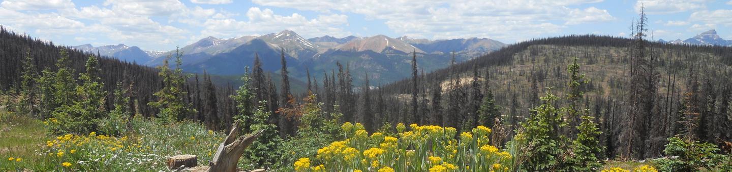
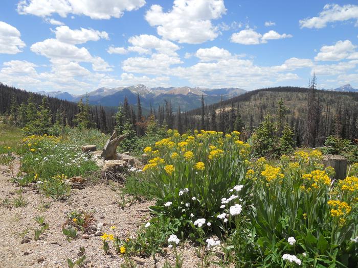
From the Sangre de Cristo to the San Juan Mountains, the jagged peaks and rushing rivers of the San Luis Valley public lands wrap themselves around this Rocky Mountain basin. Whether viewing the mountain scenery from roads or finding challenge on trails, visitors discover solitude and self-reliance through uncrowded year-round recreation opportunities.
The Rio Grande National Forest forms the scenic backdrop to the San Luis Valley. With a landscape of high peaks, geological wonders, and steep river canyons, the spectacular scenery beckons adventures from near and far.
Rio Grande National Forest offers a number of accessible recreational facilities and visitor discounts with the Interagency Access Pass for fees charged on national forests.
While many campgrounds are on a first-come basis, you can make reservations for some campgrounds. In addition there are eight cabins that are available for rental. To make reservations call: 877-444-6777 go to recreation.gov
Rio Grande National Forest Seeks Comments on Campground Fees
click here for more information
RecAreaDirections
Open with Google Map
Misc
| Stay Limit | |
| Reservable | false |
| Keywords | |
| Map Link | |
| Contact Phone | |
| Contact Email |
Permits info
Facilities
Aspen Glade (Rio Grande National Forest, CO) Campground
List of CampsitesOverview
Aspen Glade Campground sits on the Conejos River in southern Colorado, providing a premium setting for fly fishing and peaceful nature watching.Recreation
Forest Road 250 provides an unforgettable scenic drive, where visitors are met with sweeping views of the Conejos Canyon and River.Just upstream of the campground is a section of "Gold Medal" trout fishing, offering top-tier fishing for large quality trout. Just 168 miles of the 9,000 miles of trout streams in Colorado are designated with this title.
The nearby Sheep Creek Trail is also highly recommended for avid hikers.
Facilities
The 32 spacious, reservable campsites are considerably quiet, allowing for the sounds of birds overhead. Drinking water and vault toilets are provided.Natural Features
Within the campground, Loop A and B are lightly wooded with Ponderosa pines. Loop C is heavily wooded with tall, mature spruce, aspen and fir trees. It lies along the fast-flowing Conejos River. The understory for all campsites is grass topped with pine needles.Aspen Glade sits near the border of New Mexico at 8,500 feet. It is situated between the Carson and Rio Grande National Forests.
Wildlife in the region includes bear, deer, elk and a variety of birds.
Nearby Attractions
Visitors can ride a traditional steam engine at the Cumbres and Toltec Scenic Railroad on a 64-mile journey through abandoned mining towns.LAKE FORK(RIO GRANDE NATL FORE Campground
List of CampsitesOverview
Lake Fork Campground sits in the Rio Grande Forest, 40 miles northwest of Antonito, Colorado. The campground is a true getaway from any city, and requires an 18-mile drive on a gravel road. This high elevation campground boasts limitless beauty with mountain peaks, alpine wildlife spotting and several varieties of birds.Recreation
The campground is convenient to several trails, such as Lake Fork to Big Lake and Conejos Peak to Blue Lake.The Conejos River is a Gold Medal River, meaning it offers the greatest potential for trophy trout fishing. Rainbow and brown trout are the most common species in the river.
Facilities
Some campsites overlook the river. There is one centrally located drinking water spigot. All parking spurs are gravel. Firewood can be purchased on-site. No electric hookups are available.Campers will find an old-fashioned steel tub bath at Brummel's Rocky Mountain Lodge about 10 miles south.
Natural Features
The campground is located in south central Colorado on the banks of the Conejos River. It is shaded by spruce, aspen and a few cottonwoods and willows at an elevation of 9,500 feet.A variety of wildlife makes its home in the area, including black bears, deer and marmots. Wildflowers dot the region, creating colorful landscapes for photography enthusiasts.
Nearby Attractions
Take in spectacular views of the Conejos Canyon and River along Forest Road 250.MOGOTE Campground
List of CampsitesOverview
Mogote Campground is located along the Conejos River, making it a perfect location for fishing and hiking. The pleasant campground is well shaded by groves of ponderosa pine and a mixture of cottonwood, spruce, willow and aspen.The campground is also in close proximity to the Cumbres & Toltec Scenic Railroad, home of America's highest and longest, coal fired, steam operated narrow-gauge railroad.
Recreation
The Conejos River is a Gold Medal River, offering a high potential for trophy trout fishing. Rainbow and brown trout are the most common species in the river. Popular hikes include the 15-mile Elk Creek Trail and the 10.9-mile South Fork Conejos Trail.Facilities
Campsites are equipped with picnic tables and campfire rings with grills. Vault toilets, drinking water and trash bins are provided. An accessible toilet is located in the upper loop.No electric hookups are available. Firewood can be purchased on site.
Natural Features
The campground sits at an elevation of 8,400 feet, and is separated into an upper and lower loop. The lower loop sits along the fast-flowing Conejos River and many sites face the water. The campground is perched in a wooded section along the river valley.Rio Grande National Forest stretches across 1.86 million acres in south-central Colorado. The forest encompasses a myriad of ecosystems ranging from high elevation desert at 7,600 feet above sea level to rocky crags at over 14,300 feet in the majestic Sangre de Cristo Mountains.
Nearby Attractions
The Cumbres & Toltec Scenic Railroad can be accessed from Antonito. The train makes a 640-mile journey through abandoned mining towns, creating great entertainment for young and old.Big Meadows Reservoir Campground (South Central CO) Campground
List of CampsitesOverview
Big Meadows is located in the San Juan Mountains in south-central Colorado, about 11 miles west of South Fork. The campground is lightly wooded with spruce trees, creating a beautiful meadow atmosphere.The Rio Grande National Forest spans 1.86 million acres in south-central Colorado. The Continental Divide runs for 236 miles along most of the forest's western border, presenting a myriad of ecosystems from alpine desert to dense wilderness.
Recreation
An accessible fishing pier, located on the north shore of the reservoir, allows anglers to cast for rainbow, brown and brook trout. Hunting, boating and hiking are also popular pastimes.Hikers and horseback riders will enjoy the 6-mile Archuleta Trail. The trail accesses the Weminuche Wilderness, Colorado's largest wilderness, which boasts the headwaters of dozens of major streams and rivers that feed into the Rio Grande and San Juan rivers.
Facilities
Each site has a campfire ring and picnic tables. Drinking water is available.The nearest dump station is 13 miles away, and a boat ramp is located on the north shore of the reservoir.
Natural Features
The campground meanders up a mountainside above Big Meadows Reservoir in a series of loops. As a sub-alpine region, the campground gets more rainfall than the opposite side of the lake, resulting in plentiful wildflowers and aspens surrounding the campsites.Nearby Attractions
The surrounding area has plenty to keep visitors busy, with attractions like Great Sand Dunes National Park, Native American ruins, remnants of the Spanish Conquistadors and gold rush ghost towns. The Sangre de Cristo and San Juan Ranges are laced with trails for avid hikers.THIRTY MILE Campground
List of CampsitesOverview
Thirty Mile Campground is nestled on the banks of the Rio Grande River, just a short mile from the Rio Grande Reservoir. The location is perfect for anyone who loves to spend time fishing, canoeing and swimming. In addition, there are two trailheads and regular interpretive programs located at the campground.Across from the Thirty Mile is the Weminuche Wilderness, the largest wilderness area in Colorado. It's a famously rugged region with three mountain peaks reaching over 14,000 feet.
Recreation
Anglers and hikers are common campers at Thirty Mile, and the San Juan Mountains provide great fun for backpackers and horse packers.Two trailheads, Squaw Creek and Weminuche Pass, lead eager hikers into the Weminuche Wilderness and link up to the Continental Divide National Scenic Trail.
Facilities
No electric site hookups are available. Firewood is sold onsite. There is ample parking for day visitors but stock unloading and horse trailers are not permitted. Sites are designed for both tent and trailer camping. Drinking water is available.Natural Features
The campground is located in a meadow among mature spruce and aspen trees, just between the Rio Grande River and Squaw Creek. All sites are nicely shaded and some overlook the creek.The Rio Grande National Forest spans 1.86 million acres in south-central Colorado. The Continental Divide runs for 236 miles along most of the forest's western border, presenting a myriad of ecosystems from alpine desert to dense wilderness.
STONE CELLAR GUARD STATION Campground
List of CampsitesOverview
Stone Cellar Guard Station is a remote cabin located at an elevation of 9,500 feet, just outside the boundary of La Garita Wilderness in Saguache Park in the Rio Grande National Forest.The cabin is a secluded getaway for guests seeking relaxation and recreation in south-central Colorado.
Recreation
The area offers many opportunities for hiking in summer, hunting in the fall and cross country skiing and snowmobiling in the winter.The cabin is located in a meadow with Saguache Creek flowing through it, affording visitors excellent fishing for rainbow, cutthroat, brown and brook trout right out the back door.
The cabin is adjacent to a working cow camp, where guests can witness real cowboys at work during the summer months. In the fall, this cabin makes an excellent big game hunting camp.
Facilities
Stone Cellar Guard Station is a log structure furnished with four bunk beds, with twin beds on the top and fold-out full beds on the bottom, accommodating up to 12 people. The cabin has stove, refrigerator and heater, all powered with propane. The living area has a table and chairs, couch and other furniture. The kitchen is equipped with some cooking utensils and some pots and pans. A picnic table, a fire pit and a outdoor vault toilet are also on-site.There is no electricity at the guard station, however water is available by an outside hand pump. Water is also available at the Saguache Ranger District Office during business hours from May through November.
Although the cabin has some amenities, guests do need to provide their own food, sleeping bags, linens, towels, dish soap, matches, cooking gear, first aid kit, toilet paper and garbage bags.It is recommended that guests bring an additional light source in case of emergencies.
Stone Cellar Campground is located approximately about a half-mile from the guard station.
Natural Features
Situated in an expansive inter-mountain grassland and located close to the Continental Divide, this cabin offers guests seeking solitude and seclusion an opportunity to experience wilderness at its best.About 35 miles of the Continental Divide lie well above timberline in the La Garita Wilderness, adjacent to the guard station. This area provides ideal habitats for large herds of elk and mule deer, and on the southern slopes lies an ancient forest of towering spruce and fir. It is a landscape of rushing streams, broad and gentle alpine meadows, beaver ponds, long talus slopes and mountain beauty.
Nearby Attractions
Visitors may want to take a day to visit Bonanza, a historical silver mining town that was booming in the 1880s. Today visitors to Bonanza can see old mines, historical buildings and old time mining equipment as they follow the Bonanza Mines Off-Highway Vehicle Tour. Maps for the tour are available at the Saguache Ranger Station.MARSHALL PARK Campground
List of CampsitesOverview
Marshall Park Campground is situated in an open meadow on the Rio Grande River with views of Bristol Head Peak and the La Garita Mountains. Campers enjoy trout fishing, boating and the area's diverse wildlife. It also makes for a great base camp for hunters in the area.Recreation
Anglers will find an abundance of rainbow trout in the Rio Grande, which is considered a trophy river. The river also welcomes wading and exploration. Off-road vehicle trails are nearby as well.Facilities
Amenities include picnic tables and campfire rings. An accessible vault toilet with a night light is provided. Firewood may be purchased from the host. Campfire programs are presented periodically throughout the summer.No drinking water is available. Campers must bring their own supply.
Natural Features
The campground is located about 7 miles southwest of Creed, Colorado at an elevation of 8,800 feet. Campsites are open with few trees. The sun hits the campground in the late morning, after cool early morning temperatures.Rio Grande National Forest spans 1.86 million acres in south-central Colorado. The Continental Divide runs for 236 miles along most of the forest's western border, presenting a myriad of ecosystems from alpine desert to rugged wilderness.
Nearby Attractions
Head east of Creed for off-road vehicle trails like the Lost Trail #821 that runs for 11 miles and offers wonderful views of the surrounding mountains.RIVER HILL Campground
List of CampsitesOverview
River Hill is a popular campground on the banks of the Rio Grande River. Situated in a meadow surrounded by willows, campers come here to fish for trout, hunt and take in the beautiful views of the forested hills and rock bluffs. River kayaking and fishing are also popular activities, and the Rio Grande Reservoir is just a couple miles away.Recreation
Go rock climbing or horse packing in the San Juan mountains, or fish in the river, Squaw Creek or nearby Rio Grande Reservoir. Two trailheads, Squaw Creek and Weminuche Creek, lead hikers into the Weminuche Wilderness and link to the Continental Divide National Scenic Trail.Facilities
The campground features a campfire educational program on some weekend nights. Drinking water from wells is provided and garbage cans are are provided. Vault toilets are on-site.Natural Features
The campground lies in a meadow under the shade of many trees at an elevation of 9,200 feet. The Rio Grande National Forest spans 1.86 million acres in south-central Colorado. The Continental Divide runs for 236 miles along most of the forest's western border, presenting a myriad of ecosystems from alpine desert to dense wilderness.Across from the campground is the Weminuche Wilderness, the largest wilderness area in Colorado. It's a famously rugged region with three mountain peaks reaching over 14,000 feet.
ELWOOD CABIN Campground
List of CampsitesOverview
Elwood Cabin sits in a saddle along the San Juan Mountains overlooking an open meadow, offering guests a unique lodging opportunity.The cabin was built in 1911 by the Mountain States Telephone Company as a "line shack" to support crews maintaining the transcontinental telephone line. Remnants of this old telephone line are still found along Iron Creek to the southeast. The cabin was also used as a Forest Service Station from 1950 until 1962, serving as living quarters for Forest Service employees who worked on numerous projects in the area.
Although the phone line has been abandoned, today the cabin is a high-altitude getaway for guests seeking relaxation and recreation in south-central Colorado.
During summer months the cabin can be accessed by motorized travel. During winter months access to the cabin is by snowmobiles, cross country skiing or snow shoeing.
Recreation
The area around Elwood cabin offers a variety of recreational opportunities year-round. Summertime brings excellent scenic tour opportunities in and around the Summitville area as well as exploration of several historical mining sites.Anglers have a spectacular backdrop to fishing streams such as Iron Creek or Treasure Creek. Nearby Platoro Reservoir, which feeds the Conejos River, provides excellent fishing for trout and salmon.
Great hiking can be found around the area, as it spans both the Rio Grande and San Juan National Forests, as well as the South San Juan Wilderness.
In winter, the Elwood cabin area can be blanketed with as much as ten feet of snow, requiring preparation and knowledge of winter travel. Snowmobiling, skiing and snowshoeing are popular activities in the area.
Facilities
The one room log cabin is furnished with two bunk beds with single beds on the top and foldout double beds on the bottom, accommodating up to six people. The cabin has a wood stove for heat, propane lighting and a propane stove. The kitchen is equipped with a table and chairs, cooking utensils, pots and pans and a fire extinguisher. Firewood is available in the adjoining shed. An outdoor vault toilet is also on-site.Guests must provide a sufficient supply of water for cooking, cleaning and washing. Guests are also encouraged to bring an additional light source in case of emergencies.
Although the cabin has some amenities, guests do need to provide their own food, sleeping bags, linens, towels, dish soap, matches, first aid kit, avalanche equipment, toilet paper and garbage bags.
Natural Features
High in the San Juan Mountains at an elevation of 11,000 feet, this cabin provides guests with views of nearby peaks, meadows filled with wildflowers and alpine forests.While staying at such a high elevation guests will notice how light plays differently on the landscape and stars blanket the sky on clear cold evenings. Elk, deer, and other wildlife are often seen in meadows adjacent to the cabin. Bear, marmot and chipmunks also call the area home.
Nearby Attractions
Summitville is a nearby ghost town where gold was first discovered in 1870, then mined until the early 1990s. When contaminants leaked off-site and flowed into the local watershed the government forced it to shut down. Now a water treatment plant is on the site as part of a federal clean up program.CARNERO GUARD STATION Campground
List of CampsitesOverview
Carnero Guard Station is situated in a high open meadow surrounded by forest at an elevation of 9,840 feet. The high-elevation cabin is located in the north-central area of the San Luis Valley in the Rio Grande National Forest.The guard station was first proposed in 1907 by the Cochetopa National Forest, and was originally named the John Smith Ranger Station after a homesteader who built a cabin near the site, but never filed on the land. Construction on the cabin began in 1908 and the name was changed to the Carnero Guard Station in 1916.
Recreation
The cabin is a good base camp for hunting, and fishing, which is available at several creeks within a short drive. The area also offers many opportunities for hiking and off-road vehicle adventures in summer, and cross country skiing and snowmobiling in the winter.There is an off-road vehicle trail about 10 miles southwest of the cabin that travels to within 2 miles of the La Garita Wilderness.
Elk, deer, and other wildlife are often seen in meadows adjacent to the cabin, and moose have been spotted in the Moon Pass area, about 5 miles west.
Facilities
The two-room cabin is furnished with four bunk beds (the top bunk is a single bed, the bottom is a fold-out futon couch that sleeps two) and can accommodate up to 12 people. The cabin has a stove, refrigerator, heater and lighting, all powered with propane. The kitchen is equipped with a table and chairs, cooking utensils and some pots and pans. A picnic table, fire pit and an outdoor vault toilet are also on site. There is no electricity at the cabin, however water is available by an outside hand pump. Water is also available at the Saguache Ranger District Office during business hours from May through November.Natural Features
Volcanic rock outcroppings dot the forested hillsides and wide pastures near the cabin. The La Garita Wilderness is located approximately 20 miles west of the guard station and features about 35 miles of the Continental Divide well above the timberline.This area also provides habitats for large herds of elk and mule deer, and on the southern slopes, there is an ancient forest of towering spruce and fir. It is a landscape of rushing streams, broad and gentle alpine meadows, beaver ponds, long talus slopes and tremendous mountain beauty.
Nearby Attractions
Guests at Carnero Guard Station are a short drive from Penitente Canyon, which has become a great draw for rock climbing.BREWERY CREEK GUARD STATION Campground
List of CampsitesOverview
Brewery Creek Guard Station is situated at an elevation of 9,500 feet in a densely wooded aspen grove overlooking Brewery Creek. The cabin is a few miles south of the Continental Divide on the northern end of the San Luis Valley in the Rio Grande National Forest.Built in 1935, the two room cabin was originally used by a forest ranger who oversaw the Poncha and Bonanza Districts of what was then called the Cochetopa National Forest.
Today the cabin is a comfortable getaway for guests seeking relaxation and recreation in south central Colorado.
Recreation
The area offers many opportunities for hiking and off-road vehicle adventures in summer, hunting in the fall, and cross country skiing and snowmobiling in the winter.Several hiking trails are in close proximity to the cabin, including several leading up to Antora and Antora Meadows.
Facilities
The cabin is furnished with three bunkbeds (the top is a single bed, the bottom is a fold-out futon couch that sleeps two) and can accommodate up to nine people.The cabin has stove, refrigerator and heater, all powered with propane. The kitchen is equipped with cooking utensils and some pots and pans. Picnic tables, a fire pit and a outdoor vault toilet are also on site.
The guard station does not have electricity, though water is available from an outside hand pump. Water is also available at the Saguache Ranger District Office during business hours from May through November.
Although the cabin has most amenities, guests do need to provide their own food, sleeping bags, linens, towels, dish soap, matches, cooking gear, first aid kit, toilet paper and garbage bags. It is recommended that guests bring an additional light source in case of emergencies.
Natural Features
The cabin offers wonderful views of Antora Peak (13,266 feet) and Windy Point (12,129 feet) towering over the valley. Active beaver dams occupy the nearby creek just below the cabin, where anglers can cast a line into the frigid waters. Elk, deer, and other wildlife are often seen in meadows adjacent to the cabin.Nearby Attractions
Brewery Creek Guard Station is located 2 miles from Bonanza, a historical silver mining town that was booming in the 1880's. Today visitors to Bonanza can see old mines, historical buildings, and old time mining equipment as they follow the Bonanza Mines Off-Highway Vehicle Tour. Maps for the Bonanza Off-Highway Vehicle Tour are available at the Saguache Ranger Station.UPPER CROSSING GUARD STATION Campground
List of CampsitesOverview
Upper Crossing Guard Station is located at an elevation of 8,400 feet, along a scenic byway near the Continental Divide, offering visitors a comfortable lodging experience in a remote setting in Rio Grande National Forest.This guard station is the original headquarters of the old Cochetopa National Forest that existed for only a few years during the early part of the last century.
Today, guests to the guard station will find plenty of opportunities for relaxation and recreation in south central Colorado.
Recreation
The area offers many opportunities for hiking in summer, hunting in the fall and cross country skiing and snowmobiling in the winter.The cabin sits at the confluence of two creeks and offers visitors excellent fishing for rainbow, cutthroat, brown and brook trout right out the front door.
Hiking opportunities are in close proximity to the cabin, extending out to nearby wilderness and other public lands.
Facilities
Upper Crossing Guard Station has all the amenities of a standard home, including electricity, heat and inside running water. It is furnished with three bunk beds, with twin beds on the top and fold-out full beds on the bottom, accommodating up to nine people. The cabin has electric lights, propane heater and wood burning stove. The living area has a table and chairs, couch and other furniture. The kitchen is equipped with a refrigerator, stove, hot water, some cooking utensils and some pots and pans. A picnic table, campfire grill and horseshoe pit are also on-site.Although the cabin has most amenities, guests do need to provide their own food, sleeping bags, linens, towels, dish soap, matches, cooking gear, first aid kit, toilet paper and garbage bags. It is recommended that guests bring an additional light source in case of emergencies.
Natural Features
Upper Crossing Guard Station provides a remote setting that is easily accessible year-round via CO Highway 114. The brief dirt road leading to the cabin is actually the old stagecoach route, complete with historic graffiti that served as billboards advertising goods and services at the stagecoach stops.Views from the cabin include portions of the Continental Divide and unspoiled surrounding countryside, showcasing high mountain peaks, diverse forests, streams and lakes in addition to some of Colorado's most scenic working ranches.
Historically, Ute Indians traveled through this area and found it favorable for living in the San Luis Valley.
PLATORO CABIN 2 Campground
List of CampsitesOverview
Platoro Cabin 2 is located downtown in the small mining town of Platoro, Colorado, at an elevation of 10,000 feet in the Rio Grande National Forest.The cabin was built in 1963 as a base quarters for various Forest Service Crews working in the surrounding areas until the early 1990s.
Today the cabin is a getaway for guests seeking relaxation and recreation in south-central Colorado.
Recreation
The area around the cabin offers a variety of recreational opportunities year-round. Summertime brings great scenic driving tour opportunities in and around Platoro and Summitville.Anglers have a spectacular backdrop when fishing Iron Creek or Treasure Creek. The nearby Platoro Reservoir, which feeds the Conejos River, provides excellent fishing for kokanee salmon, rainbow and brown trout.
Great hiking can be found around the area, as it spans both the Rio Grande and San Juan National Forests, as well as the South San Juan Wilderness.
Big game hunting is popular in fall, while snowmobiling, skiing and snowshoeing are popular winter activities.
Facilities
The accessible cabin has a combination kitchen/living room, a bedroom and a bathroom. It is furnished with two bunkbeds, with twin beds on the top and pull-out full beds on the bottom, that can accommodate up to six people. It has a heater, stove, refrigerator and lighting, all powered by propane. The kitchen is equipped with a table and chairs and cooking gear and the bathroom has a flush toilet and shower. The cabin has entry ramps and wheelchair accessible facilities in the bathroom and the kitchen.Although the cabin has most amenities, guests do need to provide their own food, sleeping bags, linens, towels, dish soap, matches, first aid kit, toilet paper and garbage bags. Guests are also encouraged to bring an additional light source in case of emergencies.
The town of Platoro has many amenities including a grocery store, rental cabins, a small lodge, outfitter-guide services and horseback rides.
Natural Features
Platoro is a natural and unspoiled destination nestled in the San Juan Mountains of southern Colorado. Platoro started out as a boomtown in the late 1800s following the discovery of large deposits of gold and silver in the area.The nearby San Juan Wilderness is an area defined by peaks and cliffs as well as pinnacles and ridges. The headwaters for the Conejos, San Juan and Blanco Rivers are located here as well. The erosion of rich volcanic rock in combination with heavy snowfall has produced forest ecosystems in the area that transition from lodgepole pine to aspen, then through Engelmann spruce and subalpine fir to alpine tundra.
Nearby Attractions
Summitville, Colorado, is a nearby ghost town where gold was first discovered in 1870, then mined until the early 1990s.PLATORO CABIN 1 Campground
List of CampsitesOverview
Platoro Cabin 1 is located downtown in the small mining town of Platoro, Colorado, at an elevation of 10,000 feet in the Rio Grande National Forest.The cabin was built in 1963 by the Rio Grande National Forest as base quarters for various Forest Service Crews working in the surrounding areas until the early 1990s.
Today the cabin is a getaway for guests seeking relaxation and recreation in south central Colorado.
Visitors to the area should be aware that Platoro is only occupied when snow levels allow driving access, which is usually less than six months of the year.
Recreation
The area around the cabin offers a variety of recreational opportunities year-round. Summertime brings great scenic driving tour opportunities in and around Platoro and Summitville.Anglers have a spectacular backdrop while fishing Iron Creek or Treasure Creek. Nearby Platoro Reservoir, which feeds the Conejos River, provides excellent fishing for kokanee salmon, rainbow and brown trout.
Great hiking can be found around the area, as it spans both the Rio Grande and San Juan National Forests as well as the South San Juan Wilderness.
Big game hunting is popular in fall, while snowmobiling, skiing and snowshoeing are popular winter activities.
Facilities
The cabin has a combination kitchen/living room, a bedroom and a bathroom. It is furnished with two bunkbeds, with single beds on the top and foldout double beds on the bottom, accommodating up to six people. It has a heater, stove, refrigerator and lighting, all powered by propane. The kitchen is equipped with a table and chairs and cooking gear. In the bathroom there is a flush toilet and showers.Although the cabin has most amenities, guests do need to provide their own food, sleeping bags, linens, towels, dish soap, matches, first aid kit, toilet paper and garbage bags. Guests are also encouraged to bring an additional light source in case of emergencies.
Nearby Platoro Cabin #2 is similar to Platoro Cabin #1, with the addition entry ramps and wheelchair accessible facilities in the bathroom and the kitchen.
The town of Platoro has access to rental cabins, a small lodge, outfitter-guide services and horseback rides.
Natural Features
Platoro is a natural and unspoiled destination nestled in the San Juan Mountains of southern Colorado. Platoro started out as a boomtown in the late 1800s following the discovery of large deposits of gold and silver in the area.The nearby San Juan Wilderness is an area defined by peaks and cliffs as well as pinnacles and ridges. The headwaters for the Conejos, San Juan and Blanco Rivers are located here as well. The erosion of rich volcanic rock in combination with heavy snowfall has produced forest ecosystems in the area that transition from lodgepole pine to aspen, then through Engelmann spruce and subalpine fir to alpine tundra.
Nearby Attractions
Summitville is a nearby ghost town where gold was first discovered in 1870, then mined until the early 1990s. When contaminants leaked off-site and flowed into the local watershed the government forced it to shut down. Now a water treatment plant is on the site as part of a federal clean up program.ALDER GUARD STATION Campground
List of CampsitesOverview
Alder Guard Station is located 2 miles north of the town of South Fork along Alder Creek in the Rio Grande National Forest. The guard station was constructed in 1910 and was the residence and office for the local ranger district. Today the historic cabin is a comfortable getaway for guests seeking relaxation and recreation in south central Colorado.Visitors may reserve the cabin for a maximum of five nights to allow others the opportunity to rent the cabin.
Recreation
The Alder Bench trailhead is located north of the guard station on Forest Road 610. In the past, this trail was used by stockmen taking livestock up to the high country towards Blue Park and Long Park.In the fall, visitors use this trail to hunt elk and deer as this area is considered winter range for both. The 6.5 mile trail is also open for off-road single track riding, horse and foot travel, and mountain biking, but can be very rocky and steep in places.
Anglers will enjoy the scenic backdrop of Alder Creek when casting lines for a variety of trout.
Facilities
The two story cabin is furnished with 2 beds in each bedroom (2 bedrooms), and a futon on the first floor. The kitchen is equipped with a table and chairs, electric stove, refrigerator, cooking utensils and some pots and pans.
The bathroom has hot water and a flush toilet. A wood stove is the only source of heat for the guard station. Picnic tables are also on site. Firewood is not provided; please bring all the firewood you will need for your stay.
Although the cabin has several amenities, guests do need to provide their own sleeping bags, linens, towels, dish soap, matches, cooking gear, first aid kit, toilet paper and garbage bags.
Lighting is available, however guests are advised to bring an additional light source in case of emergency.
Occasionally the water well overflows due to ground water pressures. The water then may not test safely. To avoid this you are encouraged to bring spare drinking/cooking water.
Natural Features
The Rio Grande National Forest encompasses of a myriad of ecosystems ranging from high elevation desert to the craggy peaks of the majestic Sangre de Cristo Mountains.The Alder Guard Station, located in the Divide Ranger District, is surrounded by mixed conifer forests, aspen groves, and wilderness areas, though its immediate vicinity is manicured, with a fenced lawn.
OFF COW CAMP CABIN Campground
List of CampsitesOverview
Off Cow Camp is a small cabin located in a high elevation meadow at 10,500 feet on Burro Creek near an off-highway vehicle trail. The cabin and barn were renovated in 2010 and a vault toilet was installed. Visitors may reserve the cabin for a maximum of fourteen nights to allow others the opportunity to rent the cabin.Recreation
The surrounding area offers many recreation opportunities, including hunting, hiking, off-highway vehicle riding, horseback riding, mountain biking, snowmobiling, backcountry skiing, and fishing.Facilities
The small, rustic cabin sleeps four (two bunk beds). There is a wood burning cook stove, outhouse, barn for horses, fire ring, table and chairs. There is no potable water. Natural sources of water should be treated before use. Firewood not provided. Firewood can be gathered near the cabin.Natural Features
There are meadows, aspen groves and spruce/fir forests near the cabin. At 13, 200 feet, Bennett Peak sits southeast of the cabin. Fitton Guard Station is located 400 yards upstream from Off Cow Camp and is available as a rental cabin to the public.Nearby Attractions
The Burro Creek off-highway vehicle (OHV) trails connect many miles of OHV trails and forest roads in the area. The trails are also used by motorcycles, mountain bikers, hikers and horseback riders. During the winter, snowmobilers and backcountry skiers use the area near the cabin.FITTON GUARD STATION CABIN Campground
List of CampsitesOverview
Fitton Guard Station is a small cabin located in a high elevation meadow at 10,600 feet on Burro Creek near an off-highway vehicle trail. The barn was renovated in 2010 and a vault toilet was installed.Visitors may reserve the cabin for a maximum of 14 days to allow others the opportunity to rent the cabin. The combination to the cabin is provided in the confirmation letter.
Recreation
The surrounding area offers many recreation opportunities, including hunting, hiking, off-highway vehicle riding, mountain biking, snowmobiling, backcountry skiing, horseback riding and fishing.Facilities
The small, rustic cabin sleeps four (two bunk beds). There is a wood burning cook stove,outhouse, barn for horses, fire ring, table, chairs and a small covered porch. There is no potable water. Natural sources of water should be treated before use.Firewood not provided. Firewood can be gathered near the cabin.Natural Features
There are meadows, aspen groves and spruce/fir forests near the cabin. At 13, 200 feet, Bennett Peak sits southeast of the cabin. Off Cow Camp is located 400 yards downstream from Fitton Guard Station and is available as a rental cabin to the public.Nearby Attractions
The Burro Creek off-highway vehicle (OHV) trails connect to many miles of OHV trails and forest roads in the area. The trails are also used by motorcycles, mountain bikers, hikers and horseback riders. During the winter, snowmobilers and backcountry skiers use the area near the cabin.La Garita, CO Facility
Located 6 miles east of Hwy 285 on County Road G, or 12 miles north east of Del Norte on County Road 38A.
Monte Vista, CO Facility
Located at the junction of US Highways 285 & 160. Home of the Rio Grande National Forest Supervisor's Office
Bristol Head Campground Campground
List of CampsitesThis campground contains 15 sites (11 are pull through) ranging from 35 to 55 feet in length. There are both dead end spurs and pull throughs. Sits in a meadow on a bench above South Clear Creek. A short trail from campground leads to an overlook of the Clear Creek Canyons and a waterfall. The campground stretches 0.6 mile along a "bench" (a level area) above South Clear Creek. The grassy field between camping sites and creek are dotted with wild flowers. Every site has a view of towering mountains dominated by Bristol Head Peak. Spruce and Aspen line the meadow and provide some shade. The campground is an excellent area for viewing wild life, especially moose. Quiet & secluded. Fishing in the creek nearby.
14 DAY CAMPING LIMIT.
Potosi Vista Interpretive Site Facility
There are 2 interpretive sites. One site is located on the Alamosa Canyon side of Stunner Pass, partway down from the top. There are actually 2 interpretive signs at this site describing the areas history. The other site is at the bottom of Stunner Pass on the Alamosa Canyon side, near the turnoff to Platoro.
Fern Creek Trailhead # 815 Facility
near Creede, CO
Ute Creek Trailhead #819 Facility
Access to the Weminuche Wilderness
North Lime Creek Summer Trailhead # 806 & 807 Facility
Trailhead into the Weminuche Wilderness Area that accesses the Goose Creek, Goose Lake, and Fisher Mountain areas. Foot and Horse Access Only......no motorized or mechanical access allowed.
Big Meadows/Archuleta Trailhead # 839 Facility
- “Campers staying at Big Meadows between September 7 and 11, 2018 can expect loud noises between 9 am and 6 pm due to a blasting project in the Spruce Lakes area, approximately 5 miles southwest of the campground”.
This trailhead is located at the reservoir boatramp on the northeast corner of the lake.
The facility consists of a parking lot, pit toilet, and trail signing. This is a major trailhead to the Weminuche Wilderness and Archuleta Lake as well as a connector to the Continental Divide National Scenic Trail (CDNST).
Ivy Creek Trailhead # 805 Facility
Sixteen miles South West of Creede.
This trailhead offers parking, hitch rails, highline, and directional signing.
The Ivy Creek trail follows Ivy Creek from the trailhead for the first 1/2 mile to the Weminuche Wilderness boundary and then switchbacks take the hiker up and out of the Ivy Creek drainage.
This trail leads to Fisher Mountain, Goose Lake, and on to the Continental Divide Trail
Platoro, CO Facility
Located on Forest Road 250 near the Platoro Reservoir.
Gunnison, CO Facility
Located on Highway 50, 60 miles west of Highway 285.
Saguache, CO Facility
Saguache is 34 miles north of Monte Vista, junction of highway 114 and highway 285. Home of the Saguache Ranger District.
Pierce Elliott Trailhead # 851 Facility
Directions from Creede: Travel southwest on Colorado Highway 149 for 6 miles, to the intersection of Colorado Highway 149 and Forest Road #523 (Middle Creek Road), then south on Middle Creek Road #523 for approximately 4 miles, to the intersection of Road #523 and Lime Creek Road #528. Stay to the left at the "Y" intersection and follow the Lime Creek Road #528 for approximately 9 miles. The last mile and 1/4 is 4 wheel drive.
Middle Creek Trailhead #768 Facility
10 milest west of Saguache, Highway 114 to Forest road 870, travel north about 8 miles to trailhead.
Antonito, CO Facility
Located on US highway 285, 25 miles south west of Alamosa. Junction of State highway 17 is just south of Antonito.
Farmers Creek Trailhead # 801 Facility
near Creede, CO
Texas Creek Summer Home Group Trailhead Facility
Non-Motorized Trail -- Camping is not permitted at the trailhead itself since it is located within the Rio Grande Canyon, Summer Home Group. Parking for the trail is available approximately 200 yards northeast of the trail. Trail signs along the road from the parking area point the way to the trail.
Bear Town Trailhead #787 Facility
This primitive trailhead is near the end of the Beartown 4x4 road and consists of a trail sign and small parking area. From here you can access the trail 787 to West Ute Creek and also the trail to HunchBack Pass on the Continental Divide and connects with CDNST #813
Blanca, CO Facility
Blanca is on US Highway 160, 28 miles west of the top of La Veta Pass.
Miners Creek Trailhead #803 Facility
located near Creede
Alamosa Trailhead and Trail 703 Facility
Alamosa trailhead is just west of the junction of FDR 250 and FDR 260. There is limited parking here. Trail 703 begins here and goes to Comstock Campground on Rock Creek. The trail climbs steeply out of the Alamosa canyon, then becomes easier after the top is reached. It intersects with Trail 704 near the top. The descent into Comstock Campground is not as steep as the Alamosa Canyon side. The trail is open to motorcycle riding, mountain biking, horseback riding, and hiking.
South Fork, CO Facility
Located at the junction of US Highway 160 and State Highway 149.
Lobo Trailhead Facility
Lobo Overlook will be closed on Wednesday September 5th and Thursday September 6th and the CDT above Spruce Lakes will be intermittently closed Friday September 7 through Tuesday September 11? People will be able to get through on the trail but should expect some delays. THIS IS DUE TO A BLASTING PROJECT AT SPRUCE LAKES
Located at Lobo Overlook, on the Continental Divide Trail
Metroz Trailhead #833 Facility
Near Metroz Lake
Wolf Creek Ski Area Facility
The Wolf Creek Ski Area sits on 1581 acres of Forest Service lands at the top of Wolf Creek Pass. Wolf Creek is a high alpine ski resort, 10,300 feet at the base and 11,900 feet at the summit. Lifts include 1 Double, 2 Triple, 1 Quad, 1 Quad Detachable,1 High Speed Poma Lift1 Magic Carpet
Red Lake Trailhead, Trail 733 Facility
The Red Lake trailhead is on FDR 114, approx. 2 1/4 miles from Highway 17. The parking area is large enough to accommodate horse trailers and other vehicles. There is also another smaller turnaround on FDR 114 at the dead end.
Rawley 12 Trailhead Facility
near Bonanza
Villa Grove, CO Facility
Located on highway 285, 19 miles north east of Saguache.
Shallow Creek Trailhead Facility
near Creede, CO
Copper Creek Trailhead Facility
This high altitude trailhead sits at the end of Middle Creek Road 524. The facility consists of a turnaround loop, parking lot and trailhead signing. The trail from here soon enters the Weminuche Wilderness on Copper Ridge.
CDNST - Wolf Creek Trailhead Facility
This facility consists of a large parking lot and trailhead signing right at the top of Wolf Creek Pass off US Highway 160. It serves as an approach to the Continental Divide Trail in summer and as a winter approach to sledding and cross country skiing on the pass. It makes a great stopping place to visit the top of the divide and to view the surrounding San Juan Mountains.
Tewksberry Trailhead #842 Facility
Tewksberry Trail makes a gentle ascent over scenic Meadow Pass between Cattle Mountain and Demijohn Peak. Throughout the trail, spruce, Douglas fir and aspen stands shade the pathway. Interspersed with the trees are open grassy meadows. For the first 2 miles, Tewksberry Creek meanders near and occasionally crosses the trail.
A few Non-Forest Service System foot and horse trails depart from the main motorized trail. All ATV’s and Motorcycles must stay on the main motorized trail. If you wish to explore these non-system trails, park your ATV or motorcycle a few feet off the trail, and hike them.
Farmer's Creek Trailhead #801 Facility
near Creede, CO
Bonanza, CO Facility
Bonanza boomed between 1880and 1888. Silver, copper, lead and zinc were found and 1,500 mining claims came into existence,. Soon 37 building flourished along plank walks lining both sides of Kerber and Copper Creeks. The walks blended into the residential section, which grew up the hills and into the forest.
As the price of silver fell Bonanza lost its importance. By 1890 there were only 100 residents but some of the mines stayed in operation. In 1937 a fire wiped out the town of Bonanza and not many structures were rebuilt.
The remains of the Cocomongo Mill are still visible from Forest Road 862. Ore from the Bonanza Mine and Cocomongo Mine was pulverized, mixed into paste and placed in steam heated containers, Mercury and other compounds were added to the mixture to separate the gold and silver. During the mining and milling, heavy metals would seep into the nearby stream. Recently efforts have been made to restore water quality within the Bonanza Drainage.
Otto Mears participated in the mining boom by constructing at least twelve wagon roads, one of which was the Otto Mears Toll Road. It runs between Shirley and Bonanza. A gate was placed at each end of the road and a fee of 10 cents was paid to travel the road. The road wound its way up through Bonanza, over the hill to Shirley, and on to Poncha pass. A narrow gauge railroad line in Shirley picked up ore.
Valdez Trailhead, Trail 717 Facility
The Valdez trailhead is on FDR 250, 1 1/2 miles north of the Pinnacles. Parking space is limited.
West Frisco Trailhead #850 Facility
South of Del Norte
Trout Trailhead #831 Facility
The Trout trail is 10.4 miles long. It begins at Hwy 160 and ends at Forest Road 430. The trail is open for the following uses: Motorcycle Trail Riding, Off Highway Vehicles (OHV) less than or equal to 50 inches wide, Mtn Biking, Foot and Horse Travel.
Chama, NM Facility
Located on Highway 17, 10 miles south of the Colorado border.
La Jara, CO Facility
Located on US Highway 285, 14 miles south of Alamosa. Home of the Conejos Peak Ranger District.
Del Norte, CO Facility
located on highway 160, 30 miles west of Alamosa, home of the Divide Ranger District
Trout CreekTrailhead #811 Facility
near Creede, south of Highway 149, connects with West Trout Creek Trail #811 to Trout Lake and CDNST and East Trout Creek Trail # 810 to CDNST
Thirty Mile Trailhead #814 Facility
near Thirty Mile Campground
Spectacle Lake Fishing Site Facility
It is on FDR 250, across the road from Spectacle Lake Campground. Fishing is for stocked rainbows. Boats are not allowed on the lake.
Big Meadows Reservoir Boating Site Facility
The Big Meadows Boating site is a 600 acre impoundment. It offers a small boat ramp, restroom, parking lot. Motorboats are allowed but must contol excessive wakes.
Ice fishing is possible in the winter which can be accessed via snowmobile or cross-country skis on Big Meadows Road.
Bear Lake Trailhead. Trail 721 Facility
The trailhead is approx. 1 1/2 miles up FDR 105 from its junction with FDR 260. There is limited parking.
Adams Fork Trailhead, Trail 713 Facility
The trailhead is on FDR 247, about 1 mile above Platoro Reservoir. The trailhead parking is to the left of the road, the trail is across the road to the right. This area is open to dispersal camping, the space is limited.
Wheeler Geologic Area Facility
Wheeler Geologic Area is part of the La Garita Wilderness, within this area you will find many trails, some nearby peaks over 13,000 ft and amazing views. Located near the old mining town of Creede, Wheeler is accessible by a 7 mile hike or a grueling 14 mile four wheel drive road. Your efforts are rewarded by views of a remarkable geologic formation of moderately coarse volcanic tuff eroded into many different shapes. Advice is to plan a whole day trip in order to travel into Wheeler, enjoy the formations, and then get back out. It is not a short, easy trip. ROAD IS EXTREMELY ROUGH WITH DEEP RUTS HIGH CLEARANCE JEEP OR ATV TRAVEL IS RECOMMENDED.
In addition to trail # 790, East Bellows Creek Trail, from Hansons Mill, # 789 Wason- Wheeler Trail from north of Creede there are several trails that either lead to Wheeler or from Wheeler on into the La Garita Wilderness. Check out the details for the following trails, 871, 912, 784, 783 and 888.
There is a lot of information available on the internet, the following are two good sites to visit: www.gorp.com/parks-guide/travel-ta-rio-grande-national-forest-colorado-sidwcmdev_066105.html and www.sangres.com/features/wheelergeologic.htm
Kerr Lake Fishing Site Facility
The access to Kerr Lake is from the junction of FDR 250 and FDR 257. The first 2 miles to Lily Pond is a good gravel road. The last 2 miles to Kerr Lake is a rough 4-wheel drive road, high clearance recommended. The lake is a natural lake of 40 surface acres. Fishing is for cutthroat trout by artificial flies and lures only, 2 fish limit. There is limited camping around the lake. .
Road Canyon Boat Ramp Facility
This boating site consists of a small concrete ramp, restroom, parking for trucks and trailers about 1/2 way up the length of the reservoir. This lake is regularly stocked with catchable rainbow trout and also supports a natural population of Brook Trout.
No camping allowed along the reservoir, picnic area, boat ramps or parking lots.
Crestone, CO Facility
Crestone is 12 miles east of Highway 17. Turn east at the Town of Moffat.
Storm King Picnic Site Facility
Fishing in area streams, mountain biking on forest roads. 4 WD Forest Roads 685 and 684 are nearby. The picnic area is situated at the base of Storm King Mountain (elevation 10,849). It lies in an Aspen glen amidst rolling and rocky hills on the Middle Fork of Carnero Creek.
No drinking water or refuse receptacles are provided; however, 2 single picnic sites w/picnic tables, restrooms and fire grates are available.
Columbine Picnic Site Facility
This is a picnic ground and rest area along US Highway 160. No Bathrooms.
Lower South Fork Trailhead, Trail 724 & 720 Facility
There are two trailheads are within 500 yards of each other. The Lower South Fork Trailhead is the main trailhead, and South Fork Trailhead is for overflow parking. Access to Trails 724 and 720 is through these two trailheads.
East Bellows Trailhead # 790 Facility
This trail provides good hiking and horseback access to Wheeler Geologic Area, Halfmoon Pass and the La Garita Wilderness. Beautiful views and unique geologic features are the main attractions of this trail. Decent camping areas are not hard to find. Opportunities for fishing exist in East Bellows Creek. This trail allows for a good overnight backpack visit to Wheeler Geologic Area. Camping is allowed only in designated sites. No campfires are allowed within the Wheeler Geologic Area.
After arriving at Hanson’s Mill, those planning to hike to Wheeler Geologic Area should follow the trail delineated with the trailhead sign and registration box. This trail is closed to all motorized use and closed to mountain bike use after crossing East Bellows Creek as it then passes through the La Garita Wilderness.
Within about three miles from Hansons Mill the trail will cross East Bellows Creek. The old sheep bridge is no longer usable, so hikers may get their feet wet. Crossings in the early summer can be dangerous. After the creek crossing, the trail will head up the west fork of East Bellows Creek, Canon Nieve.
The trail joins the 4WD road about 1.5 miles before the geologic formations. At this junction go left (west) and follow the road to its end at a pole fence in a small meadow below Wheeler Geologic Area. The unique, picturesque features of the geologic area are about 0.25 to 0.5 mile north from the end of the road. The foot trail to Wheeler will quickly meet the West Bellows Creek trail.
The trail into Wheeler from the end of the 4WD road is well marked. It is an easy to follow trail but difficult in elevation gain that will take you on a loop trail around the formations.
This trailhead consists of a parking lot, restroom, signing, picnic tables. Overnight camping is allowed at this trailhead. This is an ideal campsite if you have horses. There is lots of room for trailers and nearby grazing. No corrals but horses could be picketed out or put into portable panels or electric fences in nearby meadows.
Platoro Reservoir Boating Site Facility
Platoro Reservoir is 990 surface acres in size, at an elevation of 10,000 feet. Fishing is for brown, rainbow and brook trout. The reservoir is open to large and small motorized and non-motorized boats. There is a boat ramp at the northeast end of the reservoir, near the dam.
Bachelor Loop Interpretive Tour Facility
This 17-mile self-guided driving tour loops through Creede’s historic silver mining district and ghost towns. The tour’s first interpretive stop is just north of Creede in Willow Creek Canyon at the juncture of East and West Willow creeks. A high clearance vehicle with low gears can traverse the graded gravel road uphill to the Equity Mine and then return to Creede via Bachelor Road (FS Road 504) and the old town site of Bachelor. There are 14 interpretive pullouts along the scenic route. The Creede Underground Mining Musuem is adjacent to the tour route at the north end of Creede. Stop by the Creede Forest Service Information office at 304 South Main Street for a guide handout to the attraction stations. There is information available on line Bachelor Historic Tour Another option for vehicles that can not climb steeper grades is to travel the loop in reverse and brake carefully down the steeper parts. Please call 719-658-2374 for current information on this attraction and the road conditions.
Upper South Fork Trailhead #720 Facility
The Upper South Fork Trail head begins at the dispersal camping site approx. 1 1/2 miles above the Lower South Fork Trailhead. There is a trail that follows the east side of the Conejos River and ends at the Lower South Fork Trailhead. The trail is open to the following uses: Mountain biking, horseback riding, hiking, and backpacking.
Mix lake Observation Facility
The Mix Lake observation site overlooks Mix Lake and the picnic site and afford a senic vista of Platoro Reservoir and the surrounding mountains.
Burro Creek Trailhead #873 Facility
This facility consists of a gravel parking lot and some trail signing. This is a major ATV friendly trailhead for the lower approach to the Burro Creek Trail # 873 right off the Pinos Creek Road # 14
Big Meadows Trailhead Facility
This is a Winter Trailhead for snowmobiling and Cross Country Skiers along US Highway 160. The trail is a groomed over the snow trail to Big Meadows Reservoir and beyond along roads 410 and 430. The trailhead is a plowed parking lot with some trails signs.
Rio Grande Reservoir Boating Site Facility
This is a primitive boat ramp and reservoir access road about 1/2 way along the Rio Grande Reservoir. There is a vault toilet here. Not recommended for large boats and long trailers. Motors are allowed on this large reservoir. Fish are stocked during summer months.
Trujillo Meadows Boating Site Facility
Trujillo Meadows Reservoir is 69 surface acres in size. The lake offers fishing for browns, rainbows and occasional brook trout. There is a boat ramp, small motorized and non-motorized boats are allowed. The lake is a no-wake lake.
Three Forks Trailhead 712 Facility
The Three Forks Trailhead starts at the end of Forest Development Road 247. It is open to parking for vehicles and horse trailers. There is a turnaround sufficient to accomodate large trucks and trailers. There is also a restroom located there.
Lost Trailhead #821 Facility
Off road 520 near lost Trail Campground
Deep Creek Trailhead #806 Facility
The trailhead is located due south of the Creede, CO airport. This facility consists of a parking lot and trailhead signing for the Deep Creek Trail.
Creede, CO Facility
Located on Highway 149, 22 miles north west of South Fork & 48 miles south east of Lake City..
Valle Verde Group Picnic Site Facility
CLOSED AS A DEVELOPED SITE. This site is a historical girl scout camp that closed in 2012 and is now managed as a walk in area off the road. It is still a general dispersed camping site but has no restroom, no parking areas. - For more info call Divide District Office 719-657-3321
Beaver Mountain Trailhead #933 Facility
This trailhead is accessed on the east end by Forest Road 350.1A and on the west by the Beaver Creek road at the South Fork Guard Station.
Pole Creek Trailhead #820 Facility
near the headwaters of the Rio Grande River
Wilderness areas Facility
Wilderness is defined as a portion of land set aside by the 1964 Congressional Wilderness Act that will remain unspoiled for future generations. The Wilderness Act gave the U.S. Forest Service a mandate to manage these special lands so they would be "an enduring resource," one that would remain "unimpaired for future use and enjoyment as wilderness."
In contrast with those areas where man and his own works dominate that landscape, a wilderness is recognized as an area '…where the earth and its community of life are untrammeled by man, where man himself is a visitor who does not remain". Wilderness areas are generally over 5,000 acres in size and may contain ecological, geological, or other features of scientific, educational, scenic, or historical value.
Please view the special regulations associated with Wilderness and always use Leave No Trace techniques to help keep these areas wild, clean, and pristine.
Rio Grande National Forest manages four Wilderness areas:
La Garita Wilderness: Rio Grande Facility
Congress designated the La Garita Wilderness in 1964 and it now has a total of 129,626 acres. La Garita means "the lookout" in Spanish, and this Wilderness amply deserves the name. From the summit of this Wilderness's single fourteener (14,014-foot San Luis Peak), climbers can gaze across the upper Rio Grande Valley and down the long stretch of the San Luis Valley.
About 35 miles of the Continental Divide lie well above a sprawling forestland that provides ideal habitats for huge numbers of elk and mule deer. Wason Park, Silver Park and Wheeler Geologic Area were added in 1993. This is a land of rushing streams, broad and gentle subalpine meadows, fascinating beaver ponds, long talus slopes, and tremendous mountain beauty.
The Wheeler Geologic Area hides in the southeast corner of the Wilderness. This unusual geological formation is composed of fine, light-gray volcanic ash compressed into rock and wildly eroded into a striking series of domes, spires, caves, ledges, pinnacles, ravines, and balanced rocks. A bumpy four-wheel drive road was left out of wilderness designation, allowing motorized access to within ½ mile of the area.
Many trailheads open onto approximately 175 miles of pathways, almost all especially well-suited for horse packing. About 27 miles of the Colorado Trail and Continental Divide National Scenic Trail follow the divide through La Garita Wilderness.
Please always use Leave No Trace techniques to help keep these areas wild, clean, and pristine.
Mix Lake Facility
Mix Lake is 25 surface acres in size, at an elevation of 10,000 feet. Fishing is for Brown, Rainbow, and Brook trout.
ELK CREEK CAMPGROUND (RIO GRANDE NF) Campground
List of CampsitesOverview
Elk Creek Campground is located in Conejos County, approximately 23 miles west of Antonito, Colorado. Located in the lower portion of the Conejos Canyon a short distance from Highway 17, it is an easily reached destination for visitors to the area. Elk Creek runs alongside the campground. The elevation of the campground is 8,500 ft.Recreation
Consider a day trip to the Cumbres and Toltec Scenic Railroad (steam) which offers a 64-mile journey through abandoned mining towns. One access to the train is in Antonito, CO, about 23 miles from the campground.Fishing, hunting, hiking, scenic driving and wildlife watching are some of the popular activities in the area. Elk Creek and Duck Lake trailheads are a short distance away, both of which are access points to the South San Juan Wilderness Area.
