
Kasha-Katuwe Tent Rocks National Monument
July 9, 2021 update: Kasha-Katuwe Tent Rocks National Monument is currently closed to the public. During the closure, BLM has had the opportunity to work on projects to enhance the visitor experience upon reopening. Projects include upgrade to trails to alleviate safety concerns within the monument. In addition, the monument has published its first Draft Business Plan outlining the current state of the Kasha-Katuwe Tent Rocks National Monument Recreation Program to ensure consistency with required statutes and laws, and establishes future management goals and priorities of the program. The draft business plan is currently out for public comment until July 9, 2021. While the initial closure was an attempt to reduce COVID-19 exposure to the gateway community of Pueblo de Cochiti, BLM has decided to maintain the closure status of the Monument until a reopening plan has been finalized. BLM is continuing to work in close cooperation with the Pueblo de Cochiti to develop a reopening plan to address long standing issues including over-visitation, long wait times, staffing needs, and ability to provide resource protection.It is BLM's hope that through these efforts, the Monument will re-open in a way that reduces impacts on the land and resources, as well as to the Cochiti people, and will provide an improved experience for all visitors. As reopening plans become more solidified, BLM will be releasing new information to the public via https://www.blm.gov/visit/kktr and our social media pages. We look forward to seeing our visitors when we reopen!
June 28, 2021 update: Kasha-Katuwe Tent Rocks Business Plan is now open for Public Comment through July 9, 2021.To view the plan please visit https://www.blm.gov/albuquerque-do/public-room/strategic-plan/draft-kasha-katuwe-tent-rocks-national-monument-business.
The Kasha-Katuwe Tent Rocks National Monument is a remarkable outdoor laboratory, offering an opportunity to observe, study, and experience the geologic processes that shape natural landscapes. The National Monument, on the Pajarito Plateau in north-central New Mexico, includes a national recreation trail and ranges from 5,570 feet to 6,760 feet above sea level. It is for foot travel only, and contains two segments that provide opportunities for hiking, birdwatching, geologic observation, and plant identification.
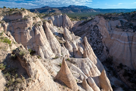
The cone-shaped tent rock formations are the products of volcanic eruptions that occurred 6 to 7 million years ago and left pumice, ash, and tuff deposits over 1,000 feet thick. Tremendous explosions from the Jemez volcanic field spewed pyroclasts (rock fragments), while searing hot gases blasted down slopes in an incandescent avalanche called a pyroclastic flow.
Precariously perched on many of the tapering hoodoos are boulder caps that protect the softer pumice and tuff below. Some tents have lost their hard, resistant caprocks, and are disintegrating. While fairly uniform in shape, the tent rock formations vary in height from a few feet up to 90 feet.
Please note that dogs are not allowed in the Monument.
Hours of Operation
Entry into the Monument between 8:00 a.m. and 4:00 p.m.
Closing procedures begin at 3:30pm to clear the Monument by 5pm.
Visitors must be out of the fee booth gated area by closing time.
During the summer months, the Monument experiences increased visitation. Please be aware that visitors may experience entrance delays starting at 9am due to increased visitation and lack of available parking. Wait times may range from 30 to 90 minutes. As parking is made available, new visitors will be allowed entry.
The monument will be closed on New Year's Day (January 1); January 6; Friday before Easter; Saturday before Easter; Easter Sunday; Monday after Easter Sunday; May 3; July 13; July 14; July 25; November 1; Thanksgiving Day; Christmas Eve; Christmas Day; and New Year's Eve.
RecAreaDirections
From Albuquerque, head north on I-25 and take the exit for Santo Domingo/Cochiti Lake Recreation Area (Exit 259) off I-25 onto NM 22. Follow the signs on NM 22 to Cochiti Pueblo and Kasha-Katuwe Tent Rocks National Monument.
From Santa Fe, head south on I-25 and take the Cochiti Pueblo Exit 264 off I-25 onto NM 16. Turn right off NM 16 onto NM 22, and follow the signs to Cochiti Pueblo and the National Monument.
Note, following the GPS coordinates may take you through tribal lands that are not accessible. Please follow the directions above and access the Monument from I-25.
Misc
| Stay Limit | |
| Reservable | false |
| Keywords | |
| Map Link | |
| Contact Phone | |
| Contact Email |
Permits info
Facilities
Kasha Katuwe Tent Rocks National Monument Ticketed Entry Ticket Facility
Designated by US Congress in 2001, Kasha-Katuwe Tent Rocks National Monument is part of the Pajarito Plateau in north-central New Mexico. Wind and water erosion has created unique cone-shaped rock formations from pumice, ash, and tuff deposits from volcanic eruptions that occurred 6 to 7 million years ago. This area is recognized as the ancestral homelands of the Cochiti and is managed today in close cooperation with the Pueblo. Visitors can experience the geology and cultural significance of this area by hiking the challenging Slot Canyon Trail or taking a moment to reflect at Veterans’ Memorial Overlook. The Bureau of Land Management in coordination with our partners in the gateway community of Pueblo de Cochiti will implement a day use reservation system in order to reopen Kasha Katuwe Tent Rocks National Monument and meet the CDC, state and local guidance related to COVID-19. Advance reservations are required for all visitors. Each private vehicle entering the Monument will need a reservation. Visitors with a reservation may enter as early as 8 a.m. until 2 p.m. The Monument will remain open until 5:00 p.m., at which time all visitors must exit. The Monument is a popular destination from Albuquerque and Santa Fe, so early reservations are recommended!
