
Black Warrior and Tombigbee Lakes
The Black Warrior & Tombigbee Lakes (BW&T) consist of six lakes (Demopolis, Coffeeville, Warrior, Oliver, Holt and Bankhead) with a combined total length of 457 miles and 39,800 surface acres of water. There are boat launching ramps at nearly all the Corps public recreation areas. There are three privately owned marinas that provide fuel, boat repair, supplies, rentals and meet other boater needs. Boaters from across the State and the country come here for their boating pleasures. Whether water-skiing, sightseeing, sailing, powerboating or jet skiing, these waters are for everyone!


RecAreaDirections
Bankhead, Holt and Oliver Lakes: From Tuscaloosa, 10 mi E on AL 216 to Peterson Asst. Resource Manager's Office. Warrior, Demopolis and Coffeeville Lakes: From Demopolis, US 80 W 2 mi to Lock & Dam road to the Resource Manager's Office.
Open with Google MapMisc
| Stay Limit | |
| Reservable | false |
| Keywords | |
| Map Link | |
| Contact Phone | |
| Contact Email |
Permits info
Direction
From Bishop go north onHwy 395 approximately 12 miles and go west on Pine Creek Canyon Rd. Drive to the end of the road and park in the dirt lotnear Pine Creek Pack Station. The trailhead is through the pack station at the base of the hill.
Important Information
DOWNLOAD AREA MAP FOR THIS TRAIL:Click Here.
Italy Pass Area:
- Special approval is required for commercial use of this area. Italy Pass trail is not recommended for stock between Italy Pass and the junction with the John Muir Trail.
- No campfires above the wilderness boundary in Pine Creek Canyon; and no campfires above 10,000 ft. look at USFS Webpage for campfire restriction maps.
- Food and refuse must be stored so that animals cannot get into the food or trash.
- Check the area map for the correct trail name. Trips going toward Pine Creek Pass, Gable Lakes or Morgan Pass are a different reservation.
- John Muir Wilderness Regulations Apply
- Deadline: Reservation will be canceled unless the permit pick up instructions are completed before the deadline. Instructions are in the confirmation letter.
- Only the group leader or alternate leader may pick up the permit; the person picking up the permit must be going on the wilderness trip.
- BE SURE YOUR DATES AND TRAIL ARE CORRECT - The entire group must start on the trail on the entry date listed. Reservations cannot be changed or transferred
USFS Webpage for: Italy Pass.
Long Description
This trail separates from the Pine Creek Pass Trail near Honeymoon Lake. Before reaching Italy Pass, the trail gives access to Granite Park and the Chalfant Lake area. After crossing Italy Pass, the trail descends past Jumble Lake to reach Lake Italy, shaped like an Italian boot. The Italy Pass Trail is not recommended for stock between Italy Pass and the junction with the John Muir Trail. Separate quotas apply for Pine Creek Pass and other area trails. Refer to the area map for trail names.
Facilities
Belmont Park Campground
List of CampsitesOverview
Belmont Park offers a primitive campground and access to some of the best public hunting and fishing opportunities on the Tombigbee River. The area gives quick access to properties located on the David K. Nelson Wildlife Management Area as well as areas managed by the Corps of Engineers. Campers will appreciate the group shelter and water borne restroom facilities conveniently located on the grounds.
Finches Ferry Campground
List of CampsitesOverview
Finches Ferry is located on the Black Warrior River near the city of Eutaw, Alabama. Park amenities include a boat ramp, shelter, and waterborne restrooms. The single-lane boat ramp provides access to fishing and other recreational opportunities.
Lock 6 Campground
List of CampsitesOverview
Lock 6 Park is located on what once was a working lock and dam on the Black Warrior River. The boat ramp provides access to fishing and other recreation opportunities. Visitors will appreciate the group shelter and restroom facilities conveniently located on the grounds.
Lock 8 Campground
List of CampsitesOverview
Lock 8 Park is situated on the banks of the Black Warrior River. The park offers a boat ramp, picnic shelter, flush toilet and paved parking. An interesting feature is an artesian well flowing onsite.
Rocky Branch Day Use Park Campground
List of CampsitesOverview
Rocky Branch Day use park is located on Holt Lake on the Black Warrior-Tombigbee Waterway northeast of Tuscaloosa, Alabama. The facility is in a beautiful forest along the shoreline, providing day-use visitors with access to water sports, boating, fishing, swimming, hiking and biking.
Recreation
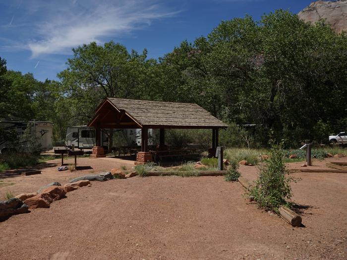
Day Users can explore the lake shore using the hiking trail as well as the swim beach. There are numerous picnic tables and grills to choose from as well as 2 reservable shelters for picnicking.
Facilities
Rocky Branch has 88 picnic sites to choose from with grills nearby. Two group shelters with grills, a water born bathroom as well as an improved and maintained swim beach available for users.
Natural Features
Holt Lake was created by the damming of the Black Warrior River. The campground is situated amidst a mixed pine and hardwood forest, which displays colorful foliage along the riverbanks each fall. Deer, squirrel, wild turkey, migratory birds and blue birds, all live in the Holt Lake area. The Black Warrior-Tombigbee Waterway consists of six lakes with a total length of 457 miles and 39,800 surface acres of water. Temperatures range from the 80s to 90s from April through September, and annual rainfall averages about 60 inches.
Nearby Attractions
Boat ramp available year round is adjacent to seasonal day use facilities.
contact_info
Between 06/09/2021 and 09/06/2021 this location is staffed. Please call (205) 388-2458 to speak with local staff. From 09/07/2021 to 05/27/2022 this location is unstaffed. Please call (205) 553-9373 for general information.Spillway Falls Campground
List of CampsitesOverview
Spillway Falls Park overlooks the Tombigbee River and the falls created by the Demopolis Lock and Dam. Beautiful vistas make this a perfect site to birdwatch or just relax. The park offers individual picnic shelters, a large group shelter, a 3.5 mile hiking trail system, boat ramp, paved parking, and two flush toilets. On-site park hosts control after-hours access.
Lock 8 Park Day Use Passes Activity Pass
FOSCUE CREEK Campground
List of CampsitesOverview
Foscue Creek Campground is nestled on the forested lake shore of Demopolis Lake, the largest lake on the Black Warrior-Tombigbee Waterway.Demopolis Lake offers 10,000 acres of water to explore. The region is excellent for hunting, and game is plentiful.
Foscue Creek Campground offers a peaceful retreat for families, anglers, boaters and those who want to get away any time of year.
Recreation
Fishing and hunting are the most popular activities in the area. Whether fishing by boat or along the bank of the park, anglers can fish for bass, crappie, bream, catfish and other species.Day-use visitors and campers alike can enjoy a boat ramp and hiking trail at the campground. Foscue Creek Nature Trail takes walkers and joggers along the shoreline and provides benches for wildlife viewing and trail markers for tree identification.
Facilities
This facility has both a day-use area and a campground. There are four shelters for group picnics of between 25 to 80 people.The 54 campsites feature picnic tables, lantern holders and campfire rings with grill. Campsites are spacious, private and located near or close to the water.
Natural Features
The campground lies south of the confluence of the Black Warrior and Tombigbee Rivers. The Black Belt region of Alabama is a diverse area of dense conifer stands and rolling meadows that feature colorful wildflower displays. Wood ducks, bald eagles, blue birds and many other species of wildlife inhabit the lake area.Black Warrior-Tombigbee Waterway consists of six lakes with a total length of 457 miles and 39,800 surface acres of water.
contact_info
For facility specific information, please call (334) 402-1608.DEERLICK CREEK Campground
List of CampsitesOverview
Deerlick Creek Campground is located on Holt Lake on the Black Warrior-Tombigbee Waterway northeast of Tuscaloosa, Alabama.The facility is in a beautiful forest along the shoreline, providing campers and day-use visitors with access to water sports, boating, fishing, swimming, hiking and biking.
Recreation
Campers can explore the lakeshore using the campground's hiking trails as well as a paved bicycle trail. The waterway is popular for fishing for bass, crappie, bream, catfish and more.
Facilities
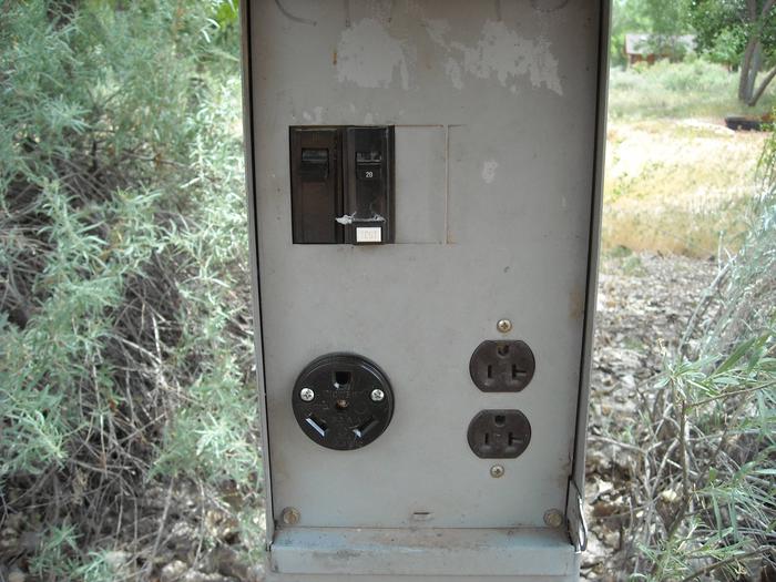
Deerlick Creek has 46 campsites with water and electric hookups, six of which are designated tent only. There is also one group picnic shelter that can be reserved for day use. Families with children have the convenience of showers, a multi-use court and swimming beach.Natural Features
Holt Lake was created by the damming of the Black Warrior River. The campground is situated amidst a mixed pine and hardwood forest, which displays colorful foliage along the riverbanks each fall. Deer, squirrel, wild turkey, migratory birds and blue birds, all live in the Holt Lake area. The Black Warrior-Tombigbee Waterway consists of six lakes with a total length of 457 miles and 39,800 surface acres of water. Temperatures range from the 80s to 90s from April through September, and annual rainfall averages about 60 inches.
contact_info
For facility specific information, please call (205) 388-1111.Nearby Attractions
Deerlick Creek is 17 miles from the University of Alabama where you can find sporting events, museums, and other attractions. Deerlick Creek is also located 13 miles from Ol' Colony Golf Course home to the University of Alabama golf teams as well as a disc golf course.
FORKLAND Campground
List of CampsitesOverview
Forkland Campground is located in a beautiful wooded area on the northern shore of Demopolis Lake, the largest lake on the Black Warrior-Tombigbee Waterway.Demopolis Lake offers 10,000 acres of water to explore and serves as a quiet and convenient retreat from the two nearby cities of Demopolis and Tuscaloosa, Alabama.
Recreation
Fishing is the most popular activity on the waterway. Whether fishing by boat or along the bank of the park, anglers can find bass, crappie, bream, catfish and other species.Day-use visitors and campers alike can enjoy a boat ramp and hiking trail at the campground, both of which are located across from the gatehouse. The trail has scenic overlooks of McConnico Creek and the Black Warrior River.
Facilities
The campground is in a comfortable setting, with 42 campsites along the lakeshore. All sites come equipped with water hookups.
Families with children enjoy the state-of-the-art playground and the convenience of showers, and picnic areas. Large groups can reserve a picnic shelter for day use that can accommodate up to 50 people.
Natural Features
Forkland Park is situated on a high point of land in a pine and hardwood mixed forest with plenty of shade. The Black Belt region of Alabama is a diverse area of dense conifer stands and rolling meadows that feature colorful wildflower displays. Wood ducks, bald eagles, blue birds and many other species of wildlife inhabit the lake area.Black Warrior-Tombigbee Waterway consists of six lakes with a total length of 457 miles and 39,800 surface acres of water.
contact_info
For facility specific information, please call (334) 402-1604.SERVICE Campground
List of CampsitesOverview
Service Campground is situated along the high banks of Coffeeville Lake, the third largest lake on the Black Warrior-Tombigbee Waterway in Alabama. With a surface area of 8,800 acres and a length of 97 miles, the area provides excellent opportunities for camping, fishing and boating.Recreation
Fishing is the most popular activity on the waterway. Whether fishing on or off shore, anglers can fish for bass, crappie, bream, catfish and other species.Visitors have the convenience of a boat ramp, and children can make use of the facility's playground. Campers can also sit back and enjoy the peaceful, scenic shoreline.
Facilities
Service Park offers 32 campsites, including two tent-only sites, all with 50-amp electric and water hookups, picnic table, lantern holder and campfire ring with grill.
Campsites are spacious, private and located near or close to the water. The facility also provides a bathouse with hot showers and other comforts of home.
Natural Features
A mixed pine and hardwood forest lines the lakeshore. The campground is surrounded by dense conifer stands and rolling meadows that feature colorful wildflower displays. Wood ducks, bald eagles and many other species of wildlife inhabit the lake area.Black Warrior-Tombigbee Waterway consists of six lakes with a total length of 457 miles and 39,800 surface acres of water.
contact_info
For facility specific information, please call (334) 402-1605.BURCHFIELD BRANCH PARK Campground
List of CampsitesOverview
Burchfield Branch Park is located near Holt Lake on the Black Warrior-Tombigbee Waterway northeast of Tuscaloosa, Alabama. With many amenities, access to the water and opportunities to view wildlife, Burchfield Branch provides a convenient camping spot for families, boaters, swimmers, picnickers and sightseers.Recreation
Fishing is the most popular activity on the waterway. Whether fishing by boat or along the shore of the park, anglers can find bass, crappie, bream, catfish and more.Families can enjoy biking and swimming along the lakeshore, watching for birds and animals or taking advantage of the facility's two playgrounds.
Facilities
Burchfield Branch Park has 36 sites with electric and water hookups, as well as one reservable group picnic shelter for day use. RV campers have the convenience of hot showers, a dump station and trash receptacles.Natural Features
Holt Lake was created by the damming of the Black Warrior River. The campground is situated along the forested shores of the river and displays scenic fall foliage each year. Deer, squirrel, wild turkey, migratory birds and blue birds live around the Holt Lake area.Black Warrior-Tombigbee Waterway consists of six lakes with a total length of 457 miles and 39,800 surface acres of water.
Temperatures range from the 80s to 90s from April through September, and annual rainfall averages about 60 inches.
JENNINGS FERRY Campground
List of CampsitesOverview
Jennings Ferry Campground is situated between the Black Warrior River and Clear Creek on the Black Warrior-Tombigbee Waterway in Alabama. With a boat ramp and gently sloping shoreline, this facility offers a quiet and convenient getaway for fishing.Recreation
Fishing is the most popular activity on the waterway. Whether fishing by boat or along the shore of the park, anglers can fish for bass, crappie, bream, catfish and other species.Visitors can also enjoy walking along a half-mile nature trail that runs through the woods following the water's edge.
Facilities
Jennings Ferry has 52 campsites with 50-amp electrical and water hookups and picnic areas.
Campsites are spacious, private and located near or close to the water. A shower and restroom building, as well as a playground and a boat ramp with security lighting that are provided for camper convenience.
Natural Features
The campground is surrounded by the scenic woodlands of the Tombigbee River. Deer, squirrel, wild turkey, migratory birds and blue birds live among the calm waters and hardwood forests of the area.Temerature range from the 80s to 90s from April to September, and annual rainfall averages about 60 inches. The facility is located 100 feet above sea level.
contact_info
For facility specific information, please call (334) 402-1606.Charges & Cancellations
USACE Reserves the right to modify/cancel reservations due to site closures.
