
Shasta-Trinity National Forest
Recreation Information
- Shasta-Trinity National Forest officials have issued a new Forest Order for the Delta & Hirz Fires that reduces the size of the closed area. It will reopen much of the National Forest System land that was closed earlier for public safety. Please note that the Slate Creek area remains closed due to numerous hazards. Please be aware that fire hazards may remain such as snags, burned out stump holes, unstable terrain, and rolling logs or rocks. The new Forest Order No. 14-18-20 goes into effect immediately.
- Forest Recreation Report Includes a link to our forest's Recreation Opportunity Guides, Mt. Shasta climbing conditions, and important specific Ranger District information.
- Recreation Facilities Guide Complete forest campground, day use and other recreational facilities.
- Permitted Outfitter, Guide, and Marina List
- Accessible Features of Forest Recreation Facilities updated Nov 2017
Know Before You Go
Season of Use
Most recreation sites within the STNF are open from May 15 through September 15. During the remainder of the year, some sites may be kept open as needed or as weather permits. Recreational facilities that remain open will offer reduced services. Some water systems are turned off during the winter months.
Length of Stay
Camping at improved campgrounds is limited to the maximum number of days posted at the site (generally no more than 14 days). Camping outside of improved campgrounds (dispersed camping) is limited to thirty (30) days within a one (1) year period, starting with the first day of occupancy.
Fees
Family campground fees range from $10 to $115 per day, depending on the types of services offered. Group campground fees range from $30 to $140 per night. Fee listings for individual campground are available upon request. There is a $6 fee for a second vehicle (if space allows) at some sites.
Pets
Pets are allowed in the recreation areas unless posted. They must be on a leash not longer than six feet, or otherwise under physical restrictive control when in a developed site.
Campfire Permits
Campfire permits are required outside of a designated campsite and may be obtained free of charge from your nearest Forest Service, CAL FIRE or BLM office.
Dispersed Camping
Generally, dispersed camping is allowed outside of developed sites within the STNF unless otherwise posted. The exception to this is Lewiston Lake. Camping is prohibited within 1/4 mile of the high water mark with no exceptions.
Fireworks and Firearms
It is prohibited to discharge a firearm or any other implement capable of taking human life, causing injury, or damaging property: (1) in or within 150 yards of a residence, building, campsite, developed recreation site, or occupied area, or (2) across or on a Forest Development road, or a body of water adjacent thereto, or in any manner or place whereby any person or property is exposed to injury or damage as a result of such discharge. (261.10d)
It is illegal to discharge or ignite a firecracker, rocket or other fireworks, or explosive on all National Forest lands (261.14d) and in Shasta County.
More Frequently Asked Questions
RecAreaDirections
Open with Google Map
Misc
| Stay Limit | |
| Reservable | false |
| Keywords | |
| Map Link | |
| Contact Phone | |
| Contact Email |
Permits info
Facilities
Shasta-Trinity National Forest - Bailey Cove Boat Ramp Activity Pass
Shasta-Trinity National Forest - Antlers Boat Ramp Activity Pass
Skunk Point Group Campground Campground
List of CampsitesOverview
Skunk Point Group Campground is located 1.9 miles east of Big Bar, CA along CA Highway 299 at an elevation of 1200'. Located on the Wild and Scenic portion of the Trinity River, this campground is a wonderful place to camp when enjoying all the river has to offer.
Recreation
The Trinity River offers fun-filled hours of fishing, swimming, floating, rafting, kayaking and boating. River access is available at this location for boats that can be carried by hand. Nearby tributaries to the Trinity River offer beautiful spots to swim and spend the day.
Generally, Pigeon Point to Big Flat is too dangerous for tuber and family canoeists. Boating is no advisted from Cedar Flat to Grays Falls except for expert boaters. Several commercial guides operate on the Trinity River under Forest Service Special Use permits. They provide quality guided raft and white water instruction and can be found on the Shasta-Trinity NF website.
**Please note that the Trinity River is subject to periodic changes in flow conditions from releases from Lewiston Dam. Current flows (CFS) can be obtained by calling (530) 246-7594.
Facilities
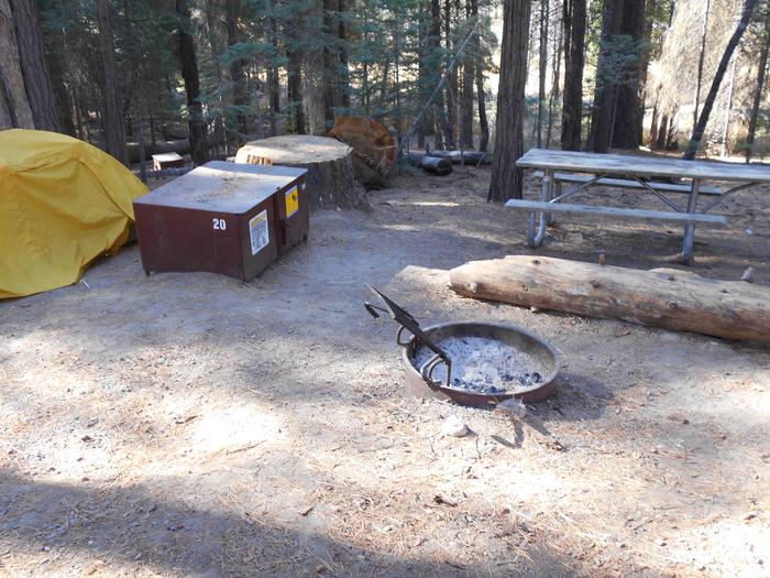
There is one group site located at this campground. There are picnic tables, fire rings and vault toilets. No potable water is available.
Natural Features
Located on the Wild and Scenic portion of the Trinity River, this campground has a beautiful view of the river.
MCCLOUD BRIDGE Campground
List of CampsitesOverview
McCloud Bridge Campground is located on the McCloud Arm of Shasta Lake, it has a total of 14 sites; 3 double sites and 11 single sites with an average back in around 35ft. This campground has vault restrooms and water spigots. There are picnic tables, bear lockers, and fire rings with grills on top located at each site. The campground is on the water when the lake is at full pool. The campground is 17 miles back on Gilman Road making it a more remote campground. This campground has no cell service.
This Campground is on a First Come - First Serve Basis, vistors are required to physically be at the campground to purchase and claim a site. You must also occupy the area the day you pay for it, no advance payments. We encourage our visitors to download the recreation.gov app to take advantage of the Scan & Pay Option. There is also a Iron Ranger on site that you can pay with cash or check.
Recreation
Shasta is perfect for everyone whether you are a boater, angler or camper. There is something for everyone. Enjoy multiple marinas and natural wonders making it the perfect destination for adventure.
Different Species of fish in Shasta Lake include rainbow trout, brown trout, largemouth bass, smallmouth bass, spotted bass, Chinook salmon, bluegill, black crappie, Sacramento sucker, white sturgeon, squawfish, white catfish, Threadfin shad, brown bullhead, golden shiner, green sunfish, riffle sculpin.
Trout fishing – best during spring fishing on the McCloud Arm north of Hirz Bay, The Sacremento arm, Big Backbone Creek, and Little Squaw Creek, during summer trout move to deeper lake levels – successful baits are live minnows, and marshmallow /egg combinations. Successful lures used for trolling are Kastmasters, Rebels, Thinfins, Z-rays, Z-r or X-5 Flatfish, and Rapalas.
Bass Fishing – Good year round but best during spring and early summer, fishing in shallower waters is best. Successful baits are mostly live baits, rubber worms, and spinner baits.
Facilities
A public boat ramp is located approximately 7 miles away at Hirz Bay (dependent on water level), but informal mooring is allowed if the water levels are sufficient.
To view current ramp information visit our website: Ramp Information
Natural Features
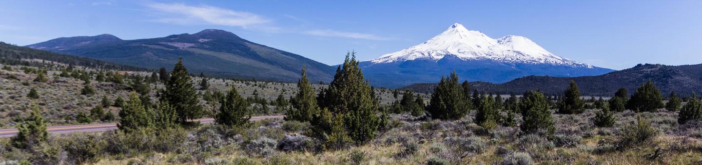
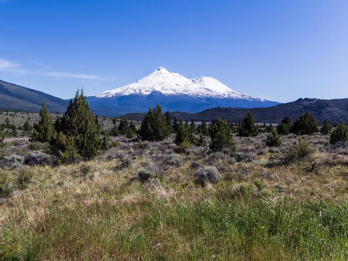
Shasta-Trinity is the largest national forest in California with a diverse landscape encompassing five wilderness areas, hundreds of mountain lakes and 6,278 miles of streams and rivers. Lake Shasta sits at an elevation of 1,067 feet, with 365 miles of shoreline punctuated by steep mountains blanketed in manzanita and evergreens. A snow-capped Mount Shasta, the second-tallest mountain in the Cascade Range, looms in the distance. Lakeside sites at McCloud Bridge offer excellent views and access to the water when lake is at full pool. Wildlife is abundant in the area.
contact_info
This location is unstaffed. To speak with our main office for general information, please call: (530) 275-8113.Nearby Attractions
There are several attractions in the area for a list view our website: Local Attractions
Charges & Cancellations
Refunds for Check or Cash Purchases: Refunds for cash payments will be issued a check or cash refund. A refund will be processed within 30 days of receipt and approval. For cash or check refunds please call us at 530-275-8113. Please Note! Refund requests made during or after departure can only be processed when approved by the facility management staff based upon local policy.
Refunds for Emergency Closures: In the event of an emergency closure the Recreation.gov will attempt to notify users and offer alternate dates and sites (as appropriate). If this is not possible, reservations will be canceled and all fees paid will be refunded.
Refunds for Naturally Occurring Events: Refunds will not be issued for naturally occurring events like rain, snow, wind, smoke, extreme temperature, low lake level, etc.
If you are requesting a refund for a walk-up site, please contact the host on-site or call us 530-275-8113. All refunds must be approved and issued through our office or processed though Recreation.gov.
Eagle Creek (CA) Campground
List of CampsitesOverview
Eagle Creek Campground is located on Trinity River and Eagle Creek, it has 17 single sites with an average back in around 16ft. This campground has vault restrooms and no water. There are picnic tables and fire rings with grills on top located at each site. The road is rough and it is a more primitive campground.
This Campground is on a First Come - First Serve Basis, vistors are required to physically be at the campground to purchase and claim a site. You must also occupy the area the day you pay for it, no advance payments. We encourage our visitors to download the recreation.gov app to take advantage of the Scan & Pay Option. There is also a Iron Ranger on site that you can pay with cash or check.
Recreation
Trinity offers wholesome memories, perfect for families, adventures and everything in-between. There are multiple hiking trails and rivers making it the perfect destination for exploration. Popular activities on Trinity Lake include boating, fishing, sailing and water skiing.
Different Species of fish in Trinity Lake include smallmouth bass, largemouth bass, rainbow trout, catfish, kokanee salmon, Chinook salmon.
Bass fishing – dredger piles near the head of the lake is the most promising locations. Fishing near the shoreline during spring (March-June) is best.
Trout fishing – found year-round throughout the lake but best during spring where they can be found nearly anywhere. During the summer months trout tend to stay near the mouths of the major tributaries.
Facilities
A public boat ramp is located approximately 20 miles away at Bowerman (dependent on water level).
To view current ramp information visit our website: Ramp Information
Natural Features
Trinity Lake is one of the largest reservoirs in California, it has an elevation around 2,387' with around 145 miles of shoreline. Trinity is made up of 3 arms: Papose, Buckeye and Stuart Fork Arm. The Water Volume of Trinity Lake: 2,447,650 acre-ft. There are a variety of coves and arms perfect for fishing or a quiet picnic on the water. The main body of the lake has plenty of room for water sports like wakeboarding or tubing.
Nearby Attractions
There are several attractions in the area for a list view our website: Local Attractions
Gregory Beach Dispersed Area (CA) Campground
List of CampsitesOverview
Gregory Beach Camping/Day Use Area is located on the Sacramento River Arm of Shasta Lake, it has trash and portable restrooms provided in season. This is a shoreline area and doesn't have designated sites.
This Campground is on a First Come - First Serve Basis, vistors are required to physically be at the campground to purchase and claim a site. You must also occupy the area the day you pay for it, no advance payments. We encourage our visitors to download the recreation.gov app to take advantage of the Scan & Pay Option. There is also a Iron Ranger on site that you can pay with cash or check.
Dispersed Area has no facilities and is pack in/pack out in winter months typically Mid September to Mid May - no fees are due during that time.
Recreation
Shasta is perfect for everyone whether you are a boater, angler or camper. There is something for everyone. Enjoy multiple marinas and natural wonders making it the perfect destination for adventure.
Different Species of fish in Shasta Lake include rainbow trout, brown trout, largemouth bass, smallmouth bass, spotted bass, Chinook salmon, bluegill, black crappie, Sacramento sucker, white sturgeon, squawfish, white catfish, Threadfin shad, brown bullhead, golden shiner, green sunfish, riffle sculpin.
Trout fishing – best during spring fishing on the McCloud Arm north of Hirz Bay, The Sacremento arm, Big Backbone Creek, and Little Squaw Creek, during summer trout move to deeper lake levels – successful baits are live minnows, and marshmallow /egg combinations. Successful lures used for trolling are Kastmasters, Rebels, Thinfins, Z-rays, Z-r or X-5 Flatfish, and Rapalas.
Bass Fishing – Good year round but best during spring and early summer, fishing in shallower waters is best. Successful baits are mostly live baits, rubber worms, and spinner baits.
Catfishing – best during summer nights on the main arms of the lake. Best baits are chicken liver, anchovies, and stink baits used at low depths.
Facilities
A public boat ramp is located approximately 6 miles away at Antlers (dependent on water level), but informal mooring is allowed if the water levels are sufficient.
To view current ramp information visit our website: Ramp Information
Provided trash service and portable toilets in season. This is a shoreline area with no formal sites.
Natural Features
Shasta-Trinity is the largest national forest in California with a diverse landscape encompassing five wilderness areas, hundreds of mountain lakes and 6,278 miles of streams and rivers. Lake Shasta sits at an elevation of 1,067 feet, with 365 miles of shoreline punctuated by steep mountains blanketed in manzanita and evergreens. A snow-capped Mount Shasta, the second-tallest mountain in the Cascade Range, looms in the distance. Wildlife is abundant in the area.
Nearby Attractions
There are several attractions in the area for a list of a few view our website: Local Attractions
Charges & Cancellations
Refunds for Check or Cash Purchases: Refunds for cash payments will be issued a check refund. A refund will be processed within 30 days of receipt and approval. For cash or check refunds please call us at 530-275-8113. Please Note! Refund requests made during or after departure can only be processed when approved by the facility management staff based upon local policy.
Refunds for Emergency Closures: In the event of an emergency closure the Recreation.gov will attempt to notify users and offer alternate dates and sites (as appropriate). If this is not possible, reservations will be canceled and all fees paid will be refunded.
Refunds for Naturally Occurring Events: Refunds will not be issued for naturally occurring events like rain, snow, wind, smoke, extreme temperature, low lake level, etc.
If you are requesting a refund for a walk-up site, please contact the host on-site or call us 530-275-8113. All refunds must be approved and issued through our office or processed though Recreation.gov.
Jones Valley Inlet Dispersed Area (CA) Campground
List of CampsitesOverview
Jones Valley Inlet Dispersed/Day Use Area is located on the Pit River Arm of Shasta Lake, it has trash and portable restrooms provided in season. This is a shoreline area and doesn't have designated sites.
This Campground is on a First Come - First Serve Basis, vistors are required to physically be at the campground to purchase and claim a site. You must also occupy the area the day you pay for it, no advance payments. We encourage our visitors to download the recreation.gov app to take advantage of the Scan & Pay Option. There is also a Iron Ranger on site that you can pay with cash or check.
Dispersed Area has no facilities and is pack in/pack out in winter months typically Mid September to Mid May - no fees are due during that time.
Recreation
A public boat ramp is located approximately 2 miles away at Jones Valley (dependent on water level), but informal mooring is allowed if the water levels are sufficient. This area is popular for water skiing and jet skiing. Lake Shasta offers excellent fishing for trout, catfish, Chinook salmon, crappie, bluegill, white sturgeon, brown bullhead and bass.
Facilities
Provided trash service and portable toilets in season. This is a shoreline area with no formal sites.
Natural Features
Shasta-Trinity is the largest national forest in California with a diverse landscape encompassing five wilderness areas, hundreds of mountain lakes and 6,278 miles of streams and rivers. Lake Shasta sits at an elevation of 1,067 feet, with 365 miles of shoreline punctuated by steep mountains blanketed in manzanita and evergreens. A snow-capped Mount Shasta, the second-tallest mountain in the Cascade Range, looms in the distance. Wildlife is abundant in the area.
Nearby Attractions
There are several attractions in the area for a list of a few view our website: Local Attractions
Charges & Cancellations
Refunds for Check or Cash Purchases: Refunds for cash payments will be issued a check or cash refund. A refund will be processed within 30 days of receipt and approval. For cash or check refunds please call us at 530-275-8113. Please Note! Refund requests made during or after departure can only be processed when approved by the facility management staff based upon local policy.
Refunds for Emergency Closures: In the event of an emergency closure the Recreation.gov will attempt to notify users and offer alternate dates and sites (as appropriate). If this is not possible, reservations will be canceled and all fees paid will be refunded.
Refunds for Naturally Occurring Events: Refunds will not be issued for naturally occurring events like rain, snow, wind, smoke, extreme temperature, low lake level, etc.
If you are requesting a refund for a walk-up site, please contact the host on-site or call us 530-275-8113. All refunds must be approved and issued through our office or processed though Recreation.gov.
Jones Valley Inlet West Dispersed Area (CA) Campground
List of CampsitesOverview
Jones Valley Inlet West Dispersed/Day Use Area is located on the Pit River Arm of Shasta Lake, it has trash and portable restrooms provided in season. This is a shoreline area and doesn't have designated sites.
This Campground is on a First Come - First Serve Basis, vistors are required to physically be at the campground to purchase and claim a site. You must also occupy the area the day you pay for it, no advance payments. We encourage our visitors to download the recreation.gov app to take advantage of the Scan & Pay Option. There is also a Iron Ranger on site that you can pay with cash or check.
Dispersed Area has no facilities and is pack in/pack out in winter months typically Mid September to Mid May - no fees are due during that time.
Recreation
A public boat ramp is located approximately 1 mile away at Jones Valley (dependent on water level), but informal mooring is allowed if the water levels are sufficient. This area is popular for water skiing and jet skiing. Lake Shasta offers excellent fishing for trout, catfish, Chinook salmon, crappie, bluegill, white sturgeon, brown bullhead and bass.
Facilities
Provided trash service and portable toilets in season. This is a shoreline area with no formal sites.
Natural Features
Shasta-Trinity is the largest national forest in California with a diverse landscape encompassing five wilderness areas, hundreds of mountain lakes and 6,278 miles of streams and rivers. Lake Shasta sits at an elevation of 1,067 feet, with 365 miles of shoreline punctuated by steep mountains blanketed in manzanita and evergreens. A snow-capped Mount Shasta, the second-tallest mountain in the Cascade Range, looms in the distance. Wildlife is abundant in the area.
Nearby Attractions
There are several attractions in the area for a list of a few view our website: Local Attractions
Charges & Cancellations
Refunds for Check or Cash Purchases: Refunds for cash payments will be issued a check or cash refund. A refund will be processed within 30 days of receipt and approval. For cash or check refunds please call us at 530-275-8113. Please Note! Refund requests made during or after departure can only be processed when approved by the facility management staff based upon local policy.
Refunds for Emergency Closures: In the event of an emergency closure the Recreation.gov will attempt to notify users and offer alternate dates and sites (as appropriate). If this is not possible, reservations will be canceled and all fees paid will be refunded.
Refunds for Naturally Occurring Events: Refunds will not be issued for naturally occurring events like rain, snow, wind, smoke, extreme temperature, low lake level, etc.
If you are requesting a refund for a walk-up site, please contact the host on-site or call us 530-275-8113. All refunds must be approved and issued through our office or processed though Recreation.gov.
Lower Jones Valley (CA) Campground
List of CampsitesOverview
Lower Jones Valley Campground is located on the Pit River Arm of Shasta Lake, it has trash service, vault toilets and potable water. This is campground has 9 single sites and 2 double sites with an average back in around 30'.
This Campground is on a First Come - First Serve Basis, vistors are required to physically be at the campground to purchase and claim a site. You must also occupy the area the day you pay for it, no advance payments. We encourage our visitors to download the recreation.gov app to take advantage of the Scan & Pay Option. There is also a Iron Ranger on site that you can pay with cash or check.
Recreation
A public boat ramp is located approximately 1 mile away at Jones Valley (dependent on water level). This area is popular for water skiing and jet skiing. Lake Shasta offers excellent fishing for trout, catfish, Chinook salmon, crappie, bluegill, white sturgeon, brown bullhead and bass.
Facilities
Trash Service, Vault Toilets and Potable Water
Natural Features
Shasta-Trinity is the largest national forest in California with a diverse landscape encompassing five wilderness areas, hundreds of mountain lakes and 6,278 miles of streams and rivers. Lake Shasta sits at an elevation of 1,067 feet, with 365 miles of shoreline punctuated by steep mountains blanketed in manzanita and evergreens. A snow-capped Mount Shasta, the second-tallest mountain in the Cascade Range, looms in the distance. Wildlife is abundant in the area.
Nearby Attractions
There are several attractions in the area for a list of a few view our website: Local Attractions
Charges & Cancellations
Refunds for Check or Cash Purchases: Refunds for cash payments will be issued a check or cash refund. A refund will be processed within 30 days of receipt and approval. For cash or check refunds please call us at 530-275-8113. Please Note! Refund requests made during or after departure can only be processed when approved by the facility management staff based upon local policy.
Refunds for Emergency Closures: In the event of an emergency closure the Recreation.gov will attempt to notify users and offer alternate dates and sites (as appropriate). If this is not possible, reservations will be canceled and all fees paid will be refunded.
Refunds for Naturally Occurring Events: Refunds will not be issued for naturally occurring events like rain, snow, wind, smoke, extreme temperature, low lake level, etc.
If you are requesting a refund for a walk-up site, please contact the host on-site or call us 530-275-8113. All refunds must be approved and issued through our office or processed though Recreation.gov.
Preacher Meadow (CA) Campground
List of CampsitesOverview
Preacher Meadow Campground is located on Swift Creek, it has a total 44 single sites with an average back in around 16ft. The campground has vault restrooms and no water. There are picnic tables and fire rings with grills on top located at each site. The campground is a horse camp and very primitive.
This Campground is on a First Come - First Serve Basis, vistors are required to physically be at the campground to purchase and claim a site. You must also occupy the area the day you pay for it, no advance payments. We encourage our visitors to download the recreation.gov app to take advantage of the Scan & Pay Option. There is also a Iron Ranger on site that you can pay with cash or check.
Recreation
Trinity offers wholesome memories, perfect for families, adventures and everything in-between. There are multiple hiking trails and rivers making it the perfect destination for exploration. Popular activities on Trinity Lake include boating, fishing, sailing and water skiing.
Different Species of fish in Trinity Lake include smallmouth bass, largemouth bass, rainbow trout, catfish, kokanee salmon, Chinook salmon.
Bass fishing – dredger piles near the head of the lake is the most promising locations. Fishing near the shoreline during spring (March-June) is best.
Trout fishing – found year-round throughout the lake but best during spring where they can be found nearly anywhere. During the summer months trout tend to stay near the mouths of the major tributaries.
Facilities
A public boat ramp is located approximately 6 miles away at Bowerman (dependent on water level).
To view current ramp information visit our website: Ramp Information
Natural Features
Trinity Lake is one of the largest reservoirs in California, it has an elevation around 2,387' with around 145 miles of shoreline. Trinity is made up of 3 arms: Papose, Buckeye and Stuart Fork Arm. The Water Volume of Trinity Lake: 2,447,650 acre-ft. There are a variety of coves and arms perfect for fishing or a quiet picnic on the water. The main body of the lake has plenty of room for water sports like wakeboarding or tubing.
Nearby Attractions
There are several attractions in the area for a list view our website: Local Attractions
Charges & Cancellations
Refunds for Check or Cash Purchases: Refunds for cash payments will be issued a check or cash refund. A refund will be processed within 30 days of receipt and approval. For cash or check refunds please call us at 530-275-8113. Please Note! Refund requests made during or after departure can only be processed when approved by the facility management staff based upon local policy.
Refunds for Emergency Closures: In the event of an emergency closure the Recreation.gov will attempt to notify users and offer alternate dates and sites (as appropriate). If this is not possible, reservations will be canceled and all fees paid will be refunded.
Refunds for Naturally Occurring Events: Refunds will not be issued for naturally occurring events like rain, snow, wind, smoke, extreme temperature, low lake level, etc.
If you are requesting a refund for a walk-up site, please contact the host on-site or call us 530-275-8113. All refunds must be approved and issued through our office or processed though Recreation.gov.
Salt Creek Dispersed Area (CA) Campground
List of CampsitesOverview
Salt Creek Camping/Day Use Area is located on the Sacramento River Arm of Shasta Lake, it has trash and portable restrooms provided in season. This is a shoreline area and doesn't have designated sites.
This Campground is on a First Come - First Serve Basis, vistors are required to physically be at the campground to purchase and claim a site. You must also occupy the area the day you pay for it, no advance payments. We encourage our visitors to download the recreation.gov app to take advantage of the Scan & Pay Option. There is also a Iron Ranger on site that you can pay with cash or check.
Dispersed Area has no facilities and is pack in/pack out in winter months typically Mid September to Mid May - no fees are due during that time.
Recreation
A public boat ramp is located approximately 6 miles away at Antlers (dependent on water level), but informal mooring is allowed if the water levels are sufficient. This area is popular for water skiing and jet skiing. Lake Shasta offers excellent fishing for trout, catfish, Chinook salmon, crappie, bluegill, white sturgeon, brown bullhead and bass.
Facilities
Provided trash service and portable toilets in season. This is a shoreline area with no formal sites.
Natural Features
Shasta-Trinity is the largest national forest in California with a diverse landscape encompassing five wilderness areas, hundreds of mountain lakes and 6,278 miles of streams and rivers. Lake Shasta sits at an elevation of 1,067 feet, with 365 miles of shoreline punctuated by steep mountains blanketed in manzanita and evergreens. A snow-capped Mount Shasta, the second-tallest mountain in the Cascade Range, looms in the distance. Wildlife is abundant in the area.
Nearby Attractions
There are several attractions in the area for a list of a few view our website: Local Attractions
Charges & Cancellations
Refunds for Check or Cash Purchases: Refunds for cash payments will be issued a check refund. A refund will be processed within 30 days of receipt and approval. For cash or check refunds please call us at 530-275-8113. Please Note! Refund requests made during or after departure can only be processed when approved by the facility management staff based upon local policy.
Refunds for Emergency Closures: In the event of an emergency closure the Recreation.gov will attempt to notify users and offer alternate dates and sites (as appropriate). If this is not possible, reservations will be canceled and all fees paid will be refunded.
Refunds for Naturally Occurring Events: Refunds will not be issued for naturally occurring events like rain, snow, wind, smoke, extreme temperature, low lake level, etc.
If you are requesting a refund for a walk-up site, please contact the host on-site or call us 530-275-8113. All refunds must be approved and issued through our office or processed though Recreation.gov.
Trinity River (CA) Campground
List of CampsitesOverview
Trinity River Campground is located on Trinity River, it has 7 single sites with an average back in around 16ft. This campground has a vault restroom and no water. There are picnic tables and fire rings with grills on top located at each site. This campground is more primitive.
This Campground is on a First Come - First Serve Basis, vistors are required to physically be at the campground to purchase and claim a site. You must also occupy the area the day you pay for it, no advance payments. We encourage our visitors to download the recreation.gov app to take advantage of the Scan & Pay Option. There is also a Iron Ranger on site that you can pay with cash or check.
Recreation
Trinity offers wholesome memories, perfect for families, adventures and everything in-between. There are multiple hiking trails and rivers making it the perfect destination for exploration. Popular activities on Trinity Lake include boating, fishing, sailing and water skiing.
Different Species of fish in Trinity Lake include smallmouth bass, largemouth bass, rainbow trout, catfish, kokanee salmon, Chinook salmon.
Bass fishing – dredger piles near the head of the lake is the most promising locations. Fishing near the shoreline during spring (March-June) is best.
Trout fishing – found year-round throughout the lake but best during spring where they can be found nearly anywhere. During the summer months trout tend to stay near the mouths of the major tributaries.
Facilities
A public boat ramp is located approximately 18 miles away at Bowerman (dependent on water level).
To view current ramp information visit our website: Ramp Information
Natural Features
Trinity Lake is one of the largest reservoirs in California, it has an elevation around 2,387' with around 145 miles of shoreline. Trinity is made up of 3 arms: Papose, Buckeye and Stuart Fork Arm. The Water Volume of Trinity Lake: 2,447,650 acre-ft. There are a variety of coves and arms perfect for fishing or a quiet picnic on the water. The main body of the lake has plenty of room for water sports like wakeboarding or tubing.
Nearby Attractions
There are several attractions in the area for a list view our website: Local Attractions
Charges & Cancellations
Refunds for Check or Cash Purchases: Refunds for cash payments will be issued a check or cash refund. A refund will be processed within 30 days of receipt and approval. For cash or check refunds please call us at 530-275-8113. Please Note! Refund requests made during or after departure can only be processed when approved by the facility management staff based upon local policy.
Refunds for Emergency Closures: In the event of an emergency closure the Recreation.gov will attempt to notify users and offer alternate dates and sites (as appropriate). If this is not possible, reservations will be canceled and all fees paid will be refunded.
Refunds for Naturally Occurring Events: Refunds will not be issued for naturally occurring events like rain, snow, wind, smoke, extreme temperature, low lake level, etc.
If you are requesting a refund for a walk-up site, please contact the host on-site or call us 530-275-8113. All refunds must be approved and issued through our office or processed though Recreation.gov.
Beehive Dispersed Area (CA) Campground
List of CampsitesOverview
Beehive Dispersed Camping/Day Use Area is located on the Sacramento River Arm of Shasta Lake, it has trash and portable restrooms provided in season. This is a shoreline area and doesn't have designated sites.
This Campground is on a First Come - First Serve Basis, vistors are required to physically be at the campground to purchase and claim a site. You must also occupy the area the day you pay for it, no advance payments. We encourage our visitors to download the recreation.gov app to take advantage of the Scan & Pay Option. There is also a Iron Ranger on site that you can pay with cash or check.
Dispersed Area has no facilities and is pack in/pack out in winter months typically Mid September to Mid May - no fees are due during that time.
Recreation
A public boat ramp is located approximately 1 mile away at Sugarloaf (dependent on water level), but informal mooring is allowed if the water levels are sufficient. This area is popular for water skiing and jet skiing. Lake Shasta offers excellent fishing for trout, catfish, Chinook salmon, crappie, bluegill, white sturgeon, brown bullhead and bass.
Facilities
Provided trash service and portable toilets in season. This is a shoreline area with no formal sites.
Natural Features
Shasta-Trinity is the largest national forest in California with a diverse landscape encompassing five wilderness areas, hundreds of mountain lakes and 6,278 miles of streams and rivers. Lake Shasta sits at an elevation of 1,067 feet, with 365 miles of shoreline punctuated by steep mountains blanketed in manzanita and evergreens. A snow-capped Mount Shasta, the second-tallest mountain in the Cascade Range, looms in the distance. Wildlife is abundant in the area.
Nearby Attractions
There are several attractions in the area for a list of a few view our website: Local Attractions
Charges & Cancellations
Refunds for Check or Cash Purchases: Refunds for cash payments will be issued a check or cash refund. A refund will be processed within 30 days of receipt and approval. For cash or check refunds please call us at 530-275-8113. Please Note! Refund requests made during or after departure can only be processed when approved by the facility management staff based upon local policy.
Refunds for Emergency Closures: In the event of an emergency closure the Recreation.gov will attempt to notify users and offer alternate dates and sites (as appropriate). If this is not possible, reservations will be canceled and all fees paid will be refunded.
Refunds for Naturally Occurring Events: Refunds will not be issued for naturally occurring events like rain, snow, wind, smoke, extreme temperature, low lake level, etc.
If you are requesting a refund for a walk-up site, please contact the host on-site or call us 530-275-8113. All refunds must be approved and issued through our office or processed though Recreation.gov.
Bridge Camp (CA) Campground
List of CampsitesOverview
Bridge Camp Campground is located on Staurt Forts Creek, it has a total of 10 single sites with an average back in around 16ft. This campground has vault toilets and water spigots dependent on season. There are picnic tables and fire rings with grills on top located at each site. The campground is a horse camp and remote.
This Campground is on a First Come - First Serve Basis, vistors are required to physically be at the campground to purchase and claim a site. You must also occupy the area the day you pay for it, no advance payments. We encourage our visitors to download the recreation.gov app to take advantage of the Scan & Pay Option. There is also a Iron Ranger on site that you can pay with cash or check.
Recreation
Trinity offers wholesome memories, perfect for families, adventures and everything in-between. There are multiple hiking trails and rivers making it the perfect destination for exploration. Popular activities on Trinity Lake include boating, fishing, sailing and water skiing.
Different Species of fish in Trinity Lake include smallmouth bass, largemouth bass, rainbow trout, catfish, kokanee salmon, Chinook salmon.
Bass fishing – dredger piles near the head of the lake is the most promising locations. Fishing near the shoreline during spring (March-June) is best.
Trout fishing – found year-round throughout the lake but best during spring where they can be found nearly anywhere. During the summer months trout tend to stay near the mouths of the major tributaries.
Facilities
A public boat ramp is located approximately 8 miles away at Minersville (dependent on water level).
To view current ramp information visit our website: Ramp Information
Natural Features
Trinity Lake is one of the largest reservoirs in California, it has an elevation around 2,387' with around 145 miles of shoreline. Trinity is made up of 3 arms: Papose, Buckeye and Stuart Fork Arm. The Water Volume of Trinity Lake: 2,447,650 acre-ft. There are a variety of coves and arms perfect for fishing or a quiet picnic on the water. The main body of the lake has plenty of room for water sports like wakeboarding or tubing.
Nearby Attractions
There are several attractions in the area for a list view our website: Local Attractions
Shasta-Trinity National Forest - Minersville Boat Ramp Activity Pass
HAYWARD FLAT Campground
List of CampsitesOverview
Hayward Flat is one of the most popular campgrounds on Trinity Lake, offering excellent lake access and plenty of shade from Ponderosa pines and Douglas firs. Located on one of the best arms of the lake for water skiing, Hayward is favored by visitors interested in water sports.Relics from the area's Placer mining history are scattered throughout the campground, with interpretive signs providing explanations.
Recreation
A boat ramp and marina are located 3 miles away, but mooring may be available at the campground. Popular activities include power and non-motorized boating, fishing, swimming and water skiing.Anglers can fish for catfish, as well as a variety of bass, trout and salmon.
Facilities
The 98-unit family campground is comprised of 5 loops. The Dogwood and Elderberry loops provide lake views and informal mooring for boats. Every campsite has a paved spur, table and campfire ring. Most campsites also provide a bear-proof food storage locker. Additional amenities include flush toilets and drinking water. The site also offers an amphitheater with educational interpretive programs offered seasonally. Program dates and times will be posted at the campground.Natural Features
The Shasta-Trinity is the largest national forest in California with a diverse landscape ranging from 1,000 to 14,162 feet. The 2.1 million acre forest encompasses five wilderness areas, hundreds of mountain lakes and 6,278 miles of streams and rivers.Trinity Lake sits at an elevation of 2,370 feet and is surrounded by the Trinity Alps. Black bears are frequently spotted in the area, as well as bobcats, mountain lions and a variety of bird species.
Nearby Attractions
The nearby town of Weaverville is listed on the National Register of Historic Places. This former mining town offers restaurants, shopping and self-guided walking tours.TANNERY Campground
List of CampsitesOverview
Tannery Gulch Campground offers four loops of sites shaded by a mix of conifer and deciduous trees on the shores of Trinity Lake. Three of the four loops offer scenic lake views.Campers at Tannery Gulch have access to a wide range of recreational activities, and an on-site amphitheater offers programs during the summer.
Recreation
Hikers can access the half-mile Trail of the Trees from the campground. Tannery Gulch also features a boat ramp and swim beach that are only open for use by campers at the facility.Popular activities on Trinity Lake include power and non-motorized boating, fishing, sailing and water skiing. Anglers can cast for catfish, as well as a variety of bass, trout and salmon.
Facilities
Each site has a paved parking spur, picnic table and fire pit. Some also have bear-proof food lockers. Drinking water and flush toilets are provided.Natural Features
Trinity Lake sits at an elevation of 2,370 feet and is surrounded by the Trinity Alps. Black bears are frequently spotted in the area, as well as bobcats, mountain lions and a variety of bird species.
Shasta-Trinity is the largest national forest in California with a diverse landscape encompassing five wilderness areas, hundreds of mountain lakes and 6,278 miles of streams and rivers.
Nearby Attractions
The nearby town of Weaverville is listed on the National Register of Historic Places. The former mining town offers restaurants, shopping and self-guided walking tours.FAWN Campground
List of CampsitesOverview
Located on the Stuart Fork Arm of Trinity Lake, Fawn Group Campground is the most popular group site in the area. Well-shaded by oaks, Douglas firs and pines, this campground provides direct lake access and is conveniently located near other recreational sites.Recreation
A boat ramp and marina are 1 mile away. Nearby Stoney Creek Swim Area is popular spot, offering a beach and picnic area.Popular activities include lakeside camping, hiking, fishing, swimming, boating and other watersports.
Facilities
Each group loop is equipped with bear-proof food lockers, several tables and group fire grills. Each loop contains 19 separate campsites with their own tables and grills. Loop B and Loop C accommodate up to 100 people each. The unpaved spurs will handle tents and RVs between 30-40 feet. The campground roads are paved. Flush toilets and drinking water are provided.Natural Features
Shasta-Trinity is the largest national forest in California with a diverse landscape encompassing five wilderness areas, hundreds of mountain lakes and 6,278 miles of streams and rivers.Lake Shasta sits at an elevation of 1,067 feet, with 365 miles of shoreline punctuated by steep mountains blanketed in manzanita and evergreens. A snow-capped Mount Shasta, the second-tallest mountain in the Cascade Range, looms in the distance.
Nearby Attractions
The town of Weaverville is listed on the National Register of Historic Places and is only a 20 minute drive from the campground. This former mining town offers restaurants, shopping and self-guided walking tours.STONEY GROUP SHASTA-TRINITY Campground
List of CampsitesOverview
Stoney Group Campground is nestled on the banks of Stoney Creek on the Stuart Fork Arm of Trinity Lake. This group camp can accommodate up to 60 people with tents. The sites are given some shade from tall trees, and two popular recreation areas on Trinity Lake are located nearby.Recreation
The campground is adjacent to the popular Stoney Creek Swim Area, which offers a beach and picnic tables. A boat ramp and marina are located less than a mile away.Popular activities in the area include power and non-motorized boating, fishing and water skiing. Anglers can cast for catfish, as well as a variety of bass, trout and salmon.
Facilities
There are flush toilets, drinking water, group pedestal grill, fire ring, several tables and bear-proof food lockers.Natural Features
Trinity Lake sits at an elevation of 2,370 feet and is surrounded by the Trinity Alps. Black bears are frequently spotted in the area, as well as bobcats, mountain lions and a variety of bird species.Shasta-Trinity is the largest national forest in California with a diverse landscape encompassing five wilderness areas, hundreds of mountain lakes and 6,278 miles of streams and rivers.
Nearby Attractions
The nearby town of Weaverville is listed on the National Register of Historic Places. The former mining town offers restaurants, shopping and self-guided walking tours.BUSHYTAIL Campground
List of CampsitesOverview
Bushytail Campground is nestled in a grove of tall Douglas firs and Ponderosa Pines, just a short distance from Trinity Lake.This campground makes an excellent base for enjoying a variety of water sports, sightseeing and other activities and is ideal for single families and small groups.
Recreation
Trinity Lake offers a variety of recreational opportunities, including boating, water skiing, sailing, swimming and fishing. Anglers can catch catfish, in addition to a variety of salmon, trout and bass.The Clark Springs Public Boat Ramp is less than a mile from Bushytail Campground.
Hikers may be interested in the 4-mile Trinity Lakeshore Trail, which starts at the nearby Clark Springs Campground.
Facilities
Bushytail offers single, double, triple and quad sites. All sites have grills, bear-proof food lockers, campfire rings and picnic tables.
This campground has electric and water hookups in most sites and paved parking spurs. Flush toilets and drinking water are available. There are 2 coin-operated showers.
Natural Features
Shasta-Trinity is the largest national forest in California with a diverse landscape encompassing five wilderness areas, hundreds of mountain lakes and 6,278 miles of streams and rivers.Bushytail Campground is part of the Whiskeytown-Shasta-Trinity National Recreation Area. Nearby Trinity Lake sits at an elevation of 2,370 feet and is surrounded by the Trinity Alps.
Black bears are frequently spotted in the area, as well as bobcats, mountain lions and a variety of bird species.
Nearby Attractions
The nearby town of Weaverville is listed on the National Register of Historic Places. This former mining town offers restaurants, shopping and self-guided walking tours.Antlers (Shasta Lake, CA) Campground
List of CampsitesOverview
Antlers Campground is situated on a bluff above the Sacramento arm of Shasta Lake. The campground has beautiful views of the lake. There is no access to the water from this campground. The Public Boat Launch is right next to the campground for great outdoor activitites. The grounds are heavily forested with pine trees, oak and Manzanita that provide shade and some privacy. Easy access from I-5 makes Antlers is a very popular campground.
Recreation
Shasta is perfect for everyone whether you are a boater, angler or camper. There is something for everyone. Enjoy multiple marinas and natural wonders making it the perfect destination for adventure.
Different Species of fish in Shasta Lake include rainbow trout, brown trout, largemouth bass, smallmouth bass, spotted bass, Chinook salmon, bluegill, black crappie, Sacramento sucker, white sturgeon, squawfish, white catfish, Threadfin shad, brown bullhead, golden shiner, green sunfish, riffle sculpin.
Trout fishing – best during spring fishing on the McCloud Arm north of Hirz Bay, The Sacremento arm, Big Backbone Creek, and Little Squaw Creek, during summer trout move to deeper lake levels – successful baits are live minnows, and marshmallow /egg combinations. Successful lures used for trolling are Kastmasters, Rebels, Thinfins, Z-rays, Z-r or X-5 Flatfish, and Rapalas.
Bass Fishing – Good year round but best during spring and early summer, fishing in shallower waters is best. Successful baits are mostly live baits, rubber worms, and spinner baits.
Facilities
Each site has a picnic table (two in double sites), lockers for storing food, fire rings, grills, and tent pads. Sites at this campground can accommodate both tents and RVs, however there are no electric/water hookups or dump stations.There are both flush and vault toilets at this campground but no showers are available. Drinking water is provided.
Interpretive programs are hosted at the nearby amphitheater every weekend between Memorial Day and Labor Day. For more information, please call 530-275-8113.
Natural Features
The Shasta-Trinity is the largest national forest in California with a diverse landscape, encompassing five wilderness areas, hundreds of mountain lakes and 6,278 miles of streams and rivers.Lake Shasta sits at an elevation of 1,067 feet and has 365 miles of shoreline punctuated by steep mountains blanketed in Manzanita and evergreens. Snow-capped Mount Shasta, the second-tallest mountain in the Cascade Range, looms in the distance.
Nearby Attractions
Tours are available at the nearby Lake Shasta Caverns. Antlers is located in the town of Lakehead, which offers restaurants and shopping.Charges & Cancellations
If the reservation was made through recreation.gov please call 1-877-444-6777 to make a refund request. Refunds must be requested no later than 14 days before your scheduled arrival date for a full refund (excluding recreation.gov fee’s).
Refunds for Check or Cash Purchases: Refunds for cash payments will be issued a check refund. A refund will be processed within 30 days of receipt and approval. For cash or check refunds please call us at 530-275-8113. Please Note! Refund requests made during or after departure can only be processed when approved by the facility management staff based upon local policy.
Refunds for Emergency Closures: In the event of an emergency closure the Recreation.gov will attempt to notify users and offer alternate dates and sites (as appropriate). If this is not possible, reservations will be canceled and all fees paid will be refunded.
Refunds for Naturally Occurring Events: Refunds will not be issued for naturally occurring events like rain, snow, wind, smoke, extreme temperature, low lake level, etc.
If you are requesting a refund for a walk-up site, please contact the host on-site or call us 530-275-8113. All refunds must be approved and issued through our office or processed though Recreation.gov.
DEKKAS ROCK Campground
List of CampsitesOverview
Dekkas Rock Campground provides scenic views of the mountainous shoreline from the McCloud Arm of Lake Shasta. This group campground offers sites adjacent to the lake and is open for reservations year-round.Recreation
Hikers can access the trailhead for the 1-mile Hirz Bay Trail at the camp. This trail is for hikers only. The Hirz Bay public boat ramp is nearby and offers access for both motorized and non-motorized boats.Lake Shasta offers excellent fishing for trout, catfish, Chinook salmon, crappie, bluegill, white sturgeon, brown bullhead and bass. Water skiing is also a popular pastime.
Facilities
The group camp will accommodate up to 60 people. Sites are adjacent to the water, but lake levels drop as the summer progresses.The facility provides 8 large tables, 2 large pedestal grills, 1 large family barbecue grill, 2 campfire rings and 4 unpaved parking spurs.
An additional unpaved parking lot with 8 spaces is provided for boat trailers and overflow use.
Drinking water and vault toilets are available. Bear-proof food lockers are provided.
Natural Features
Shasta-Trinity is the largest national forest in California with a diverse landscape encompassing five wilderness areas, hundreds of mountain lakes and 6,278 miles of streams and rivers.Lake Shasta sits at an elevation of 1,067 feet, with 365 miles of shoreline punctuated by steep mountains blanketed in manzanita and evergreens. A snow-capped Mount Shasta, the second-tallest mountain in the Cascade Range, looms in the distance.
Nearby Attractions
Lake Shasta Caverns are also located on the McCloud Arm of Shasta Lake in an area known as the Grey Rocks. Tours are given daily at this privately owned facility.The nearby Hirz Mountain Lookout offers panoramic views of Mt. Shasta, Mt. Lassen and the surrounding area at an elevation of 3,500 feet.
LAKESHORE EAST Campground
List of CampsitesOverview
Lakeshore East sits along the shore of the Sacramento Arm of Shasta Lake. The facility is partially shaded by oak and pine and provides some privacy between sites with an undergrowth of grass and raspberry bushes.Lakeshore East is easily accessible from I-5 and offers direct access to the lake from a number of sites. Walk-ins are accepted year-round.
Recreation
Both the Antlers and Sugar Loaf public boat ramps are nearby. Antlers is approximately 2 miles from the campground. Power and non-motorized boating, fishing and waterskiing are all popular pastimes.Visitors may be able to informally moor their boats at the campground.
Anglers can fish for trout, catfish, Chinook salmon, crappie, bluegill, white sturgeon, brown bullhead and bass.
Facilities
Each site has a picnic table, raised fire ring and paved parking spur. Two yurts, which are sturdy, weather-proof shelters, are available for rent year-round.
The campground has sites that can accommodate tents as well as trailers, although there are no electrical hookups or dump stations for trailers.
Standard single sites can accommodate up to 8 people and an unlimited number of tents; double sites can accommodate up to 16 people and an unlimited number of tents.
Drinking water and flush toilets are provided, including flush toilets that meet current accessibility standards.
Natural Features
Shasta-Trinity is the largest national forest in California with a diverse landscape encompassing five wilderness areas, hundreds of mountain lakes and 6,278 miles of streams and rivers.Lake Shasta sits at an elevation of 1,067 feet, with 365 miles of shoreline punctuated by steep mountains blanketed in manzanita and evergreens. A snow-capped Mount Shasta, the second-tallest mountain in the Cascade Range, looms in the distance.
Nearby Attractions
Lake Shasta Caverns are located on the McCloud Arm of Shasta Lake in an area known as the Grey Rocks. Tours are given daily at this privately owned facility.BAILEY COVE Campground
List of CampsitesOverview
Bailey Cove Campground is nestled in a forested area on the McCloud Arm of Shasta Lake. The site is a popular destination due to its convenient access from I-5 and the adjacent public boat ramp.The area surrounding the campground offers an abundance of recreational and sightseeing opportunities.
Recreation
The campground provides access to the 3-mile Bailey Cove Trail. This trail hugs the shoreline and is open to both hikers and mountain bikers.Lake Shasta attracts anglers due to its wide variety of fish. Boaters can access the lake via the adjacent boat ramp, and boat rentals are available nearby.
Facilities
Each of the 7 sites has a tent pad, picnic table, raised fire ring, bear boxes, and paved parking spur. Brick pavers have been used to provide added accessibility. Flush toilets and drinking water are provided.There is a day use area adjoined to the campground and boat ramp, which provides parking and restrooms and pic-nic tables with bbq's and hiking trails.
Natural Features
Shasta-Trinity is the largest national forest in California with a diverse landscape encompassing five wilderness areas, hundreds of mountain lakes and 6,278 miles of streams and rivers.Lake Shasta sits at an elevation of 1,067 feet, with 365 miles of shoreline punctuated by steep mountains blanketed in manzanita and evergreens. A snow-capped Mount Shasta, the second-tallest mountain in the Cascade Range, looms in the distance.
This area boasts abundant wildlife. Osprey nests are often seen in the area around Bailey Cove Campground.
Nearby Attractions
Lake Shasta Caverns are also located on the McCloud Arm of Shasta Lake in an area know as the Grey Rocks. Tours are given daily at this privately owned facility.At an elevation of 3,500 feet, the nearby Hirz Mountain Lookout offers panoramic views of Mt. Shasta, Mt. Lassen and the surrounding area.
ELLERY CREEK Campground
List of CampsitesOverview
Ellery Creek is located on the McCloud Arm of Shasta Lake. The campground is terraced, providing views of the lake from all of the lower sites and some of the upper sites.At certain water levels, boats can be moored on the shore within sight of the campground, making Ellery Creek a very popular place to camp among boaters.
Recreation
A public boat ramp is located approximately 4 miles away at Hirz Bay, but informal mooring is allowed at Ellery Creek if the water levels are sufficient. This area is popular for water skiing and jet skiing.Lake Shasta offers excellent fishing for trout, catfish, Chinook salmon, crappie, bluegill, white sturgeon, brown bullhead and bass.
Facilities
Each site offers fair to good privacy and sufficient shade provided by the deciduous trees in the campground.There are two sets of vault toilets and water spigots throughout the camp. Each site has lockers for food, picnic tables, fire rings with grills, paved parking spurs and tent pads.
There are no showers available or electric/water hookups for trailers. All sites at this campground can accommodate small trailers as well as tents.
Natural Features
Shasta-Trinity is the largest national forest in California with a diverse landscape encompassing five wilderness areas, hundreds of mountain lakes and 6,278 miles of streams and rivers.Lake Shasta sits at an elevation of 1,067 feet, with 365 miles of shoreline punctuated by steep mountains blanketed in manzanita and evergreens. A snow-capped Mount Shasta, the second-tallest mountain in the Cascade Range, looms in the distance.
Lakeside sites at Ellery Creek offer excellent views and access to the water. Wildlife is abundant in the area.
Nearby Attractions
The Lake Shasta Caverns are also located on the McCloud Arm of Shasta Lake in an area know as the Grey Rocks. Tours are given daily at this privately owned facility.The nearby Hirz Mountain Lookout offers panoramic views of Mt. Shasta, Mt. Lassen and the surrounding area at an elevation of 3,500 feet.
The nearest store is 21 miles away in Lakehead.
HIRZ BAY Campground
List of CampsitesOverview
Hirz Bay Campground is nestled among Manzanita and oak trees on a hilltop overlooking the McCloud Arm of Shasta Lake. The scenic location offers a variety of recreational activities, including a nearby boat ramp for water sports and a hiking trail.Recreation
The nearest boat launch is about 1 mile away at Hirz Bay. Resorts on the lake have watercraft rentals and marinas with fuel.Popular water activities include power and non-motorized boating, fishing and water skiing. Lake Shasta offers excellent fishing for trout, catfish, Chinook salmon, crappie, bluegill, white sturgeon, brown bullhead and bass.
Hikers can access the 2-mile Hirz Bay Trail from the campground.
Facilities
Each campsite contains a paved parking spur, a table, a bear-proof food locker and one fire ring. This campground has a pay phone, drinking water, flush toilets and an overflow parking area.Natural Features
Shasta-Trinity is the largest national forest in California with a diverse landscape encompassing five wilderness areas, hundreds of mountain lakes and 6,278 miles of streams and rivers.Lake Shasta sits at an elevation of 1,067 feet, with 365 miles of shoreline punctuated by steep mountains blanketed in manzanita and evergreens. A snow-capped Mount Shasta, the second-tallest mountain in the Cascade Range, looms in the distance.
Nearby Attractions
Lake Shasta Caverns are also located on the McCloud Arm of Shasta Lake in an area know as the Grey Rocks. Tours are given daily at this privately owned facility.The nearby Hirz Mountain Lookout offers panoramic views of Mt. Shasta, Mt. Lassen and the surrounding area at an elevation of 3,500 feet.
MOORE CREEK Campground
List of CampsitesOverview
Moore Creek Campground is situated on the McCloud Arm of Shasta Lake. This cozy campground is partially shaded and can accommodate both tents and RVs.Camping at Moore Creek provides easy access to a variety of water sports, as well as the opportunity to enjoy scenic views and abundant wildlife.
Recreation
The nearest public boat ramp is 4 miles away at Hirz Bay. Boat rentals and fuel are available at nearby lakefront resorts. Shasta Lake is popular for power and non-motorized boating, fishing and water skiing.Anglers can fish for trout, catfish, Chinook salmon, crappie, bluegill, white sturgeon, brown bullhead and bass.
Facilities
All campsites have picnic tables, fire rings, tent pads, bear boxes and paved parking spurs. Vault toilets and drinking water are provided.Natural Features
Shasta-Trinity is the largest national forest in California with a diverse landscape encompassing five wilderness areas, hundreds of mountain lakes and 6,278 miles of streams and rivers.Lake Shasta sits at an elevation of 1,067 feet, with 365 miles of shoreline punctuated by steep mountains blanketed in manzanita and evergreens. A snow-capped Mount Shasta, the second-tallest mountain in the Cascade Range, looms in the distance.
Nearby Attractions
The nearby Hirz Mountain Lookout offers panoramic views of Mt. Shasta, Mt. Lassen and the surrounding area at an elevation of 3,500 feet.NELSON POINT Campground
List of CampsitesOverview
Nelson Point Campground is situated along the Sacramento Arm of Shasta Lake, easily accessible from 1-5 and located nearby many other recreation areas on Shasta Lake.Recreation
The nearest public boat ramp is 6 miles away at Antlers. Nearby lakeside resorts offer boat rentals and fuel.Shasta Lake is popular for power and non-motorized boating, fishing and water skiing. Anglers can fish for trout, catfish, Chinook salmon, crappie, bluegill, white sturgeon, brown bullhead and bass.
Facilities
Nelson Point is open for walk-ins April 1-May 13. The campground is available for group rental on a reservation basis from May 13-September 11. Reservations are not allowed for individual family camping during the peak season unless the entire campground is reserved. All campsites have a grill or stove, picnic tables, fire rings, tent pads, bear boxes and paved parking spurs. Vault toilets are provided, but there is no drinking water.Natural Features
Shasta-Trinity is the largest national forest in California with a diverse landscape encompassing five wilderness areas, hundreds of mountain lakes and 6,278 miles of streams and rivers.Lake Shasta sits at an elevation of 1,067 feet, with 365 miles of shoreline punctuated by steep mountains blanketed in manzanita and evergreens. A snow-capped Mount Shasta, the second-tallest mountain in the Cascade Range, looms in the distance.
Nearby Attractions
Lake Shasta Caverns is located on the McCloud Arm of Shasta Lake in an area known as the Grey Rocks. Tours are given daily at this privately owned facility.Pine Point (Shasta Lake, CA) Campground
List of CampsitesOverview
Pine Point Campground is situated along the McCloud Arm of Shasta Lake and offers sites to both tent and RV campers. Visitors to this area can enjoy boating and fishing at the nearby Shasta Lake or hiking around the Shasta-Trinity National Forest.Recreation
The nearest public boat ramp is 4 miles away at Hirz Bay. Nearby lakeside resorts offer boat rentals and fuel.Shasta Lake is popular for power and non-motorized boating, fishing and water skiing. Anglers can fish for trout, catfish, Chinook salmon, crappie, bluegill, white sturgeon, brown bullhead and bass.
Facilities
All campsites have picnic tables, grills, fire rings, tent pads, bear boxes and paved parking spurs. Vault toilets and drinking water are provided.Natural Features
Shasta-Trinity is the largest national forest in California with a diverse landscape encompassing five wilderness areas, hundreds of mountain lakes and 6,278 miles of streams and rivers.Lake Shasta sits at an elevation of 1,067 feet, with 365 miles of shoreline punctuated by steep mountains blanketed in manzanita and evergreens. A snow-capped Mount Shasta, the second-tallest mountain in the Cascade Range, looms in the distance.
Nearby Attractions
The nearby Hirz Mountain Lookout offers panoramic views of Mt. Shasta, Mt. Lassen and the surrounding area.HIRZ BAY GROUP 1 Campground
List of CampsitesOverview
The Hirz Bay Group 1 Campground sits on the McCloud Arm of Shasta Lake in a forest of oak and Manzanita. A variety of recreational activities are offered here, including a nearby boat ramp for water sports and a hiking trail. This camp is ideal for groups of up to 120 people.Recreation
The nearest boat launch is about 1 mile away at Hirz Bay. Hikers can access the 2-mile Hirz Bay Trail near the campground. Resorts on the lake have watercraft rentals and marinas with fuel.Popular water activities include power and non-motorized boating, fishing and water skiing. Lake Shasta offers excellent fishing for trout, catfish, Chinook salmon, crappie, bluegill, white sturgeon, brown bullhead and bass.
Facilities
The camp offers a picnic area, 2 large pedestal grills, 1 large fire ring, 2 large sinks with faucets and a paved parking lot with 21 spaces. The parking area is separate from the camping area.Vault toilets are provided.
Natural Features
Shasta-Trinity is the largest national forest in California with a diverse landscape encompassing five wilderness areas, hundreds of mountain lakes and 6,278 miles of streams and rivers.Lake Shasta sits at an elevation of 1,067 feet, with 365 miles of shoreline punctuated by steep mountains blanketed in manzanita and evergreens. A snow-capped Mount Shasta, the second-tallest mountain in the Cascade Range, looms in the distance.
Nearby Attractions
Lake Shasta Caverns are also located on the McCloud Arm of Shasta Lake in an area know as the Grey Rocks. Tours are given daily at this privately owned facility.The nearby Hirz Mountain Lookout offers panoramic views of Mt. Shasta, Mt. Lassen and the surrounding area at an elevation of 3,500 feet.
HIRZ BAY GROUP 2 Campground
List of CampsitesOverview
Hirz Bay Group 2 Campground sits along the McCloud Arm of Shasta Lake, shaded by a forest of oak and Manzanita. The facility offers a variety of recreational activities, including a nearby boat ramp for water sports and a hiking trail.Recreation
The Hirz Bay boat launch is a 1/2 mile from the campground. Hikers can also access the 2-mile Hirz Bay Trail near the campground. Resorts on the lake have watercraft rentals and marinas with fuel. Popular water activities include power and non-motorized boating, fishing and water skiing. Lake Shasta offers excellent fishing for trout, catfish, Chinook salmon, crappie, bluegill, white sturgeon, brown bullhead and bass.Facilities
The campground is ideal for groups of up to 80 people. The camp offers 9 picnic tables, a large pedestal grill, a large open fire ring, 2 fireplaces with grates and 2 water hydrants. Vault toilets and bear-proof food storage lockers are also provided. The parking area contains 23 paved spaces and is separate from the camping area.Natural Features
Shasta-Trinity is the largest national forest in California with a diverse landscape encompassing five wilderness areas, hundreds of mountain lakes and 6,278 miles of streams and rivers.Lake Shasta sits at an elevation of 1,067 feet, with 365 miles of shoreline punctuated by steep mountains blanketed in manzanita and evergreens. A snow-capped Mount Shasta, the second-tallest mountain in the Cascade Range, looms in the distance.
Nearby Attractions
Lake Shasta Caverns are also located on the McCloud Arm of Shasta Lake in an area known as the Grey Rocks. Tours are given daily at this privately owned facility.The nearby Hirz Mountain Lookout offers panoramic views of Mt. Shasta, Mt. Lassen and the surrounding area at an elevation of 3,500 feet.
CAMP 4 GROUP CAMPGROUND Campground
List of CampsitesOverview
This group site is nestled in the Shasta-Trinity National Forest on the Upper McCloud River, popular for its three stunning waterfalls.
Camp 4 is typically open from mid-spring through mid-fall, offering primitive accommodations near a variety of recreational activities and magnificent scenery.
Note: This is not Camp 4 in Yosemite National Park. Learn more about the Camp 4 daily lottery in Yosemite National Park.
Recreation
During the late spring, summer and early fall, the McCloud River is the most popular attraction in this area, offering fishing, swimming, camping, kayaking and plenty of photography opportunities.The Upper McCloud River, located from the point the river dumps into the McCloud Reservoir to its source, is a popular spot for trout fishing. Anglers can find rainbow, brook and McCloud River red band trout. The Lower McCloud River, which begins below the dam at the McCloud Reservoir, offers many additional angling opportunities as well.
The nearby McCloud River Falls Trail offers hikers the opportunity to view all 3 of the waterfalls, as well as take in breathtaking views of Mt. Shasta.
For hikers looking to cool off in the summer heat, the Middle Falls and Lower Falls both offer popular swimming holes, for those brave enough to take on the cool waters.
Facilities
Vehicle access to Camp 4 is mostly on paved roads, but the last 1/4 mile is gravel. The facility can accommodate 10 vehicles and up to 30 guests, with a maximum of 10 tents plus 5 RV or motor homes.The campground has no water or electricity, but there are picnic tables, vault toilets and campfire rings provided, as well as trash collection-visitors are expected to bring their own trash bags.
Water is available at the McCloud Ranger Station.
Natural Features
The Shasta-Trinity encompasses 2.1 million acres with over 6,278 miles of streams and rivers. It ranges from 1,000 ft. in elevation at Shasta Lake, to the spectacular Mt. Shasta with an elevation of 14,179 feet.
The Shasta-Trinity includes portions of 5 designated Wilderness Areas: Castle Crags, Chanchelulla, Mount Shasta, Trinity Alps and Yolla Bolly-Middle Eel.
It also sits among 7 major geographic and botanic regions: the Coast Range, Klamath Mountains, Willamette Valley, te Cascade Mountains, the High Desert, the Sierra Nevada Mountains and the Central Valley.
The Upper McCloud River features the Upper, Middle and Lower Falls, which cascade over basalt lava flows, impressing visitors and kayakers alike.
contact_info
For local information, please call (530) 964-2184 or call (530) 440-4105 for general information.Nearby Attractions
The nearest services and amenities are 9 miles from Camp 4 in McCloud, a historic mill town that offers opportunities for golfing, eating out, shopping and sightseeing.Throughout Shasta-Trinity National Forest, there are access points for the Pacific Crest Trail, a 2,663-mile trail stretching from Mexico to Canada.
Charges & Cancellations
A $10.00 service fee will apply if you change or cancel your reservation. Late cancellations are subject to additional fees. For full details see NRRS Reservation PolicyMARY SMITH CAMPGROUND Campground
List of CampsitesOverview
Mary Smith Campground is located off County Road 105, two miles north of the town of Lewiston, CA. This campground offers excellent fishing and tent camping.This campground was picked as one of California's prettiest lake campgrounds in Sunset Magazine. Many of the sites have shore access to Lewiston Lake.
Recreation
The area offers excellent opportunities for fishing, kayaking, hiking and wildlife viewing. Pine Cove boat ramp is within four miles, and Fairview launching area on Trinity Lake is nine miles north. Motorized boats are limited to ten miles per hour.Rainbow trout are abundant, and brown and brook trout are common. This is a good lake for a float tube and excellent fly fishing. The area offers wonderful wildlife viewing opportunities.
Facilities
There are six Glamping unit sites all with on-site fire pits and picnic tables. The sites offer fair to outstanding privacy. There are both flush and vault toilets, and drinking water is provided.
With the exception of the large cluster of sites at the campground entrance (Glamping camping site #'s 2, 3, 4, 5a, 5b, and 9 ADA compliant), the remaining sites are arranged in small groups. No trailers are allowed and there are no parking spurs.
Glamping Camping Unit & Site Amenities:
Inside: over-sized queen beds with feather down comforters and pillows (linen service provided), two bed-side nightstands, over-sized rugs and a boot bench.
Outside: front deck equipped with two armchairs and coffee table, fire pit and picnic table.
Natural Features
The campsites are tucked into a mixed forest of conifer and deciduous trees, surrounded by abundant wildflowers. Every site offers a view of Lewiston Lake and the surrounding Trinity Alps.Lewiston Lake is about five miles long, about 70 feet deep, and sits at an elevation of 1,902 feet. It is a favorite among anglers and paddlers.
ALPINE VIEW CAMPGROUND Campground
List of CampsitesOverview
Alpine View Campground is located in the Trinity Unit of the Whiskeytown-Shasta-Trinity National Recreation Area at an elevation of 2,400 feet. This facility is a great choice for children, the elderly and those with accessibility needs who require well-developed trails and campsites. Visitors enjoy a variety of recreational activities in a beautiful setting.Recreation
The area offers excellent opportunities for fishing, boating and hiking around Trinity Lake. The campground is very popular with the boating public, as the Bowerman boat ramp is located a quarter-mile before the campground entrance.Anglers can fish for catfish, as well as different varieties of trout, salmon and bass. Hikers can access several trails in the area, including the 0.3-mile Lake Trail.
Facilities
This is a 53-unit family campground that offers several accessible campsites and three accessible restrooms with flush toilets. The campground features paved social areas, roads and spurs. The maximum vehicle length is 32 feet.Each campsite is furnished with a picnic table and campfire ring. Some of the campsites have bear-proof food storage lockers. Drinking water is provided.
Natural Features
This scenic campground has three loops (A, B and C) with sites that wind through a grove of Douglas fir and cedar with an understory of ferns. Some sites in Loops A and B have a view of Trinity Lake.Bears frequent the area, but a wide variety of wildlife may be seen in and around Trinity Lake.
ACKERMAN CAMPGROUND Campground
List of CampsitesOverview
Ackerman Campground is a lakeside facility that's a favorite of fishermen. It is located in the beautiful Trinity Lake/Weaverville Area of Shasta-Trinity National Forest, which is part of the Whiskeytown-Shasta-Trinity National Recreation Area. The campground is open year-round for walk-ins. Reservations are accepted May 21st through September 10th.Recreation
The area offers excellent opportunities for fishing, boating and wildlife viewing. Lewiston Lake is 610 acres and offers good fishing for kokanee salmon, as well as rainbow, brown and brook trout.There are two accessible boat ramps near this facility. Fairview boat ramp access to Trinity Lake is 3 miles north and Pine Cove boat ramp access to Lewiston Lake is 2 miles south. Motorized boats are limited up to 10 miles per hour.
Lewiston Lake is a popular destination for kayakers. Hikers can enjoy the 2-mile North Lakeshore Trail.
Facilities
This campground can accommodate trailers and RVs up to 40 feet. Each site is equipped with a picnic table and a campfire ring with grill. The parking spurs are either grass or gravel.Natural Features
The campground is situated at an elevation of 1,900 feet on the western shore of Lewiston Lake at the base of Trinity Dam. Some deciduous and conifer trees are found around the campground, but it is mostly unshaded.Cold, crystal-clear Lewiston Lake is roughly 5 miles long and a half-mile wide. It features a mountainous shoreline and a topography that ranges from marshlands to dense forest.
Charges & Cancellations
MINERSVILLE CAMPGROUND Campground
List of CampsitesOverview
This campground, located 17 miles north of Weaverville, CA, off Highway 2, is situated on the Stuart Fork Arm of Trinity Lake. Minersville is one of the more popular campgrounds on Trinity Lake due to its easy access to the lake and scenic views. At 2,400 foot elevation, it is nestled in a stand of mixed conifers and deciduous trees.Trinity Lake is one of three Forest Service-managed lakes in the Shasta-Trinity National Recreation Area, offering excellent opportunities for houseboating, water skiing, tubing and wakeboarding.
Recreation
The area offers excellent opportunities for fishing, kayaking, hiking and wildlife viewing. Directly adjacent to the campground is the Minersville Boat Ramp. Informal mooring of boats is possible off some of the campsites.Rainbow trout are abundant, and brown and brook trout are common. This is a good lake for a float tube and excellent fly fishing.
The area offers wonderful wildlife viewing opportunities. Hikers can access the 4-mile Trinity Lakeshore Trail at nearby Clark Springs Campground.
Facilities
The first section of the campground is well-developed with paved, level parking aprons and amenities. The second section is mostly walk-in with good privacy between campsites, and more primitive with a wilderness feel. There are six walk-in campsites (four single, two double). In addition, there are two accessible campsites 8 & 4 . Sites have picnic tables and campfire rings with grills. Two flush toilets and one vault toilet are available. Drinking water is provided, and bear-proof containers are available. Showers are available at the neighboring Bushy Tail Campground.Natural Features
Minersville Campground is noted for a "campground with a view." Many campsites are located on the bank of Trinity Lake with views of the Trinity Alps, noted for their scenic views and alpine environment.The Trinity Alps are situated within the Klamath Mountains, which lies between the Pacific Coast Ranges to the west and the Cascade Range farther to the east.
HIRZ MOUNTAIN LOOKOUT Campground
List of CampsitesOverview
The McCloud River Wintu tribe held Hirz Mountain in reverence and had a name for it in their own language. But it was a white miner, Henry Hirz, who gave the mountain its modern name. Hirz was a gold miner who lived on Hirz Creek in the 1860s and was one of the earliest white men in the McCloud River country.When the lookout was built, it was originally a structure that sat on the ground. The mountain was a strategic location for detecting fires because it had a direct view into the headwaters of the McCloud River and most of its tributaries. In 1937, the Forest Service and the Civilian Conservation Corps (CCC) rebuilt the Hirz Mountain Lookout cabin and included a garage and outhouse. It was one of the last CCC-era lookouts to be built. In 1949, a steel tower was added, constructed of a steel K-brace tower that stands 20 feet above ground level.
Coming here is not for the faint of heart. The access road is rocky and steep with limited visibility - high clearance vehicles are recommended - and the last quarter-mile must be traversed on foot. Those who make the journey are rewarded with unforgettable views of the landscape by day and the stars at night.
Recreation
The main recreational activities at Hirz Mountain Lookout are sightseeing and stargazing, and this is an ideal setting for those with a passion for photography. Visitors may want to bring binoculars to go birding and wildlife watching.There are also opportunities to hike, mountain bike and hunt in the area.
Facilities
There are two twin beds and two additional mattresses in the lookout cabin, offering sleeping space for four people. There is a picnic table below the lookout and a vault toilet in a separate building. Cabinets and dressers are available for storage. Visitors will find cleaning supplies for tidying up the cabin when they leave.The lookout has no cooking facilities, linens, bedding, water or electricity. Visitors must bring enough water for the length of their stay, as well as garbage bags to pack out their trash. Appropriate footwear is recommended for the hike up to the lookout. Other items to consider include food, a cell phone, cook stove, matches, a cooler with ice, personal items, first aid kit, flashlights or lanterns and extra batteries. A California campfire permit is required for the use of a portable gas stove, jellied petroleum or pressurized liquid fuel for cooking (click here for more information about Hirz Mountain Lookout).
Natural Features
This lookout tower sits atop Hirz Mountain at an elevation of 3,540 feet, offering 360-degree views of Mt. Shasta's snow-laced peak to the north, Mt. Lassen to the southeast and the gray limestone exposures of Hirz Mountain itself. The narrow blue-green ribbon of the McCloud River Arm winds past the east side of Hirz Mountain, extending north and south as far as the eye can see. Visitors to Hirz Mountain Lookout are advised to use caution, as rattlesnakes and bears frequent the area (click here for information on bear safety).GIRARD RIDGE LOOKOUT Campground
List of CampsitesOverview
Girard Ridge Lookout was constructed in 1931 and used by the Forest Service on a regular basis until 1981. It is one of the few remaining historic lookouts on the Shasta-Trinity National Forest. The structure at Girard Ridge is reportedly the oldest lookout of its particular design remaining in California. It was restored to its original character in 1997. The lookout offers primitive accommodations, but visitors are rewarded with panoramic views of the mountains during the day and bright, starry skies at night. Staying at Girard Ridge Lookout is an unforgettable experience.Recreation
While the main recreation at Girard Ridge Lookout is enjoying the scenery, there are opportunities to hike, hunt, and fish. Hikers can walk north on the Forest Service road for 3 miles from the lookout to where it meets the Pacific Crest Trail.Facilities
Girard Ridge Lookout stands 13 feet off the ground and is accessed via a flight of stairs. It has a standard 14x14 foot cabin with a gable roof and exterior catwalk. There is a separate building with a vault toilet that is accessed by going down the stairs and walking about 30 feet. The cabin offers two twin beds with mattresses. Cabinets are available for storage and there is a table for eating. Visitors have access to cleaning supplies, including a mop, broom, and cleansers. The lookout has no cooking facilities, no water and no electricity. Visitors are required to bring water. A heat source is needed in cooler temperatures. There are no dishes, utensils, cookware, linens or bedding at the lookout. Visitors must bring garbage bags to pack out trash. The use of portable stoves using gas, jellied petroleum or pressurized liquid fuel is allowed with a valid California campfire permit, but no wood or charcoal fires are permitted ( Click here for more information about Girard Ridge Lookout).Natural Features
The lookout is located above the Sacramento River Canyon at a height of 4,809 feet. Spectacular views of Mount Shasta are seen to the north, the gray spires of the Castle Crags frame almost the entire view to the west and the distant silhouette of Lassen Peak can be seen to the southeast. Girard Ridge Lookout is surrounded by northern California mixed conifer forest. Bears and other animals live in the surrounding forest (click here for information on bear safety).Nearby Attractions
Castle Crags State Park is nearby, offering hiking trails, including access to the Castle Crags Wilderness in the Shasta-Trinity National Forest, and the chance to fish and swim in the Sacramento River.Charges & Cancellations
A $10.00 service fee will apply if you change or cancel your reservation. Late cancellations are subject to additional fees. For full details see NRRS Reservation PolicyPOST CREEK GUARD STATION Campground
List of CampsitesOverview
Post Creek Guard Station was built in 1934 by the Civilian Conservation Corps for use as a wildfire lookout. It is now available for recreational use. This historic guard station is eligible for inclusion to the National Register of Historic Places. Guests can drive to Post Creek Guard Station, though much of the trip is on gravel Forest roads, depending upon which route is chosen. This charming cabin offers beautiful views of the nearby mountains and forest. Some amenities are provided, but guests will have to bring supplies and gear. Post Creek Guard Station offers the chance to relish the peace and quiet in a beautiful, secluded location.Recreation
Post Creek Guard Station is an ideal location to relax and enjoy the view. Guests who want to do something a bit more active can find hiking and other recreational activities in the nearby wilderness. On hot days guests can take a dip in the swimming hole at Post Creek, located a quarter mile from the guard station.Facilities
This 19x30 cabin accommodates up to six people and has two rooms. The kitchen is equipped with a table and chairs and is fully stocked with pots, pans, dishes, and utensils. There are two barrel chairs and a coffee table in the living area. Sleeping accommodations include a queen bed, a twin bed, and a single rollaway bed on which guests can put a camp mattress, and sleeping bags can be placed on the floor to accommodate a total of six people in the cabin. There is a portable restroom located outside. There is no running water at the cabin. A fire pit and picnic table are located outside. The cabin does not have electricity, heat, a stove or refrigerator. Guests should bring their own potable water for drinking, cooking and washing; all linens including sheets, blankets, sleeping bags and/or blankets, and pillows; kitchen linens; and a camp cook stove with fuel. The use of portable stoves using gas, jellied petroleum or pressurized liquid fuel are allowed outside with a valid California Campfire Permit.Natural Features
The guard station is located in the Hayfork area of the Shasta-Trinity National Forest on a ridgeline above Beegum Gorge. Beegum Creek, which is just to the north of the cabin, is a major waterway in this area. The Yolla Bolly Mountains in the Yolla Bolly-Middle Eel Wilderness are to the south.Nearby Attractions
Guests may wish to explore the many hiking trails and mountain lakes in the nearby Yolla Bolly-Middle Eel Wilderness or dip in the cold water at Beegum Creek.FOREST GLEN GUARD STATION Campground
List of CampsitesOverview
This historic guard station offers a unique stay in the oldest Forest Service building on the Shasta-Trinity National Forest. This charming two-story structure was built in 1916 under the direction of John T. Grey, District Ranger of the Mad River Ranger District on the old Trinity National Forest.
Visitors can relax on the front porch and enjoy the tranquil surroundings from mid-April to the beginning of December.
Recreation
The South Fork National Recreational Trail can be accessed one and a half miles up the road from the cabin, or from the Scott Flat Campground when conditions permit crossing the swinging footbridge. The trail is 21 miles long, but the first 7.2-miles that parallel the South Fork Trinity River are the most traversed. The trail offers numerous scenic views. Visitors may also want to drive to Ruth Lake for a picnic and additional hiking, which is about a 45 minute drive west of the cabin. Visitors can find a few excellent swimming holes on the South Fork Trinity River.Facilities
The cabin has electricity. The lower level has a living area with two barrel chairs and a double futon, along with a large kitchen area equipped with a cook stove and refrigerator, dining table, and chairs. The kitchen is fully stocked with dishes, pots, pans, and utensils.
There is an indoor bathroom with flush toilet. There are 4 twin beds, and a double futon, and sleeping bags can be placed on the floor to accommodate a total of eight people in the cabin. Visitors should bring all bed linens (e.g., sheets, blankets, sleeping bags and/or blankets, pillows), kitchen linens, and bath towels.
A fire pit, Adirondak chairs, and picnic table are provided outside.
Space heaters are in the cabin.
Natural Features
Forest Glen Guard Station is located in the Hayfork Area, an area rich in natural beauty. One of its three major watersheds is the South Fork Trinity River, which is adjacent to the guard station and considered to be one of wildest and most scenic waterways in northern California. Glen Creek flows year round right next to the cabin. The surrounding area is forested with ponderosa pine, Douglas Fir, and oak. There are many numerous open meadows in the area.Nearby Attractions
South Fork National Recreation Trail, South Fork Trinity River, South Fork Mountain Ridge, Ruth Lake.LITTLE MT. HOFFMAN LOOKOUT Campground
List of CampsitesOverview
Little Mt. Hoffman Lookout was constructed in the 1920s and was used by the Forest Service on a regular basis until 1978. It is one of the few remaining historic lookouts in the Shasta-Trinity National Forest and is eligible for listing on the National Register of Historic Places. The lookout is still used by the Forest Service in times of extreme fire danger. The lookout is accessible by car, but the last 4 miles are on unpaved roads and difficult for RVs and cars with trailers to navigate. Visitors must bring many of their own supplies. The accommodations of this lookout may be rustic, but the views guarantee that visitors will have a memorable stay.Recreation
Little Mt. Hoffman Lookout is an ideal location for sightseeing and bird watching, and it's a photographer's dream. Visitors in search of more active pursuits can drive a short distance to hike and explore the many nearby hills, clearings and caves. Medicine Lake has a day use area with a large swim beach and a boat dock.Facilities
The lookout is a 14x14 wooden cabin that sits on the ground. Front steps lead up to the entrance and a wooden deck surrounds it. It's equipped with a wood stove, two cots, a shovel, a bucket, storage cabinets, dining table, cleaning gear and a fire extinguisher. A barbecue pit and picnic table are located outside. A vault toilet is housed in a separate building. This facility houses a maximum of four people. The lookout has no cooking facilities, water, bedding or electricity. Visitors must bring their own water supply and garbage bags to pack out their trash. Recommended supplies include food, toilet paper, linens and blankets, firewood, cooking utensils, extra batteries and a flashlight or lantern. Visitors should also remember to bring the reservation confirmation and the lock combination. The use of portable stoves using gas, jellied petroleum or pressurized liquid fuel is allowed with a valid California campfire permit (click here for more details on Little Mt. Hoffman Lookout).Natural Features
Little Mt. Hoffman is a cinder cone on the flanks of Medicine Lake Highland, the largest identified volcano within California, which extends roughly 15 miles east to west and 25 miles north to south. Medicine Lake Highland has a caldera that is partially filled by Medicine Lake. Little Mt. Hoffman sits on the rim of this caldera at 7,309 feet, providing a panoramic view of this diverse volcanic landscape. Visitors can see a spectacular view of Mt. Shasta, Mt. Lassen and southern Oregon's Mt. McLoughlin. The panorama includes the Tulelake Basin to the north, the Fall River Valley in the east and the Medicine Lake Highlands to the south.Charges & Cancellations
A $10.00 service fee will apply if you change or cancel your reservation. Late cancellations are subject to additional fees. For full details see NRRS Reservation Policy .Clark Springs Day Use Area and Beach Facility
Located off of State Route 3 on the Stuart Fork arm of Trinity Lake. There is one group picnic site and several other single sites, all with a table and pedestal grill. The picnic area is next to the beach. There is a drinking fountain. The swim beach is in an area where children and adults can swim as long as the water is within 40 feet of the high water line. It has a very gradual slope for young swimmers. The swim area is marked and a very popular place for families from the adjacent campgrounds and the community. There is a fee for the use of this area.
Clark Springs Public Boat Ramp Facility
Located 17 miles from Weaverville, north on Hwy 3. The boat ramp is useable until the water reaches 46 feet drawdown and has a courtesy dock. There is an accessible flush restroom at the swim beach/picnic area and a drinking fountain.
Cooper Gulch Day Use Area Facility
Cooper Gulch Day Use area is located 19 mile east of Weaverville, 4 miles north of Lewiston on Lewiston Lake and is situated on the water's edge and is a favorite spot for anglers. This facility is fully wheelchair accessible.
Ridgeville Boat-In Campground Campground
List of CampsitesAccessible only by boat, this campground is located on the east point of the Mule Creek cove. Total of 21 units. No piped water.
Trinity Alps Wilderness Facility
The second largest wilderness area in California, the Trinity Alps Wilderness nearly doubled in size by the 1984 California Wilderness Act. In that same year, it was added to the National Wilderness Preservation System. It currently has over 600 miles of trails and embraces over 500,000 acres of land.
Chiseled granite peaks and alpine lakes dot the Trinity Alps Wilderness, with elevations from 2,000 feet in creek drainages to 9,000 feet at summits. This wilderness offers many different trails ranging from 1.5 miles to 15 miles at varying levels of difficulty.
Management of the Wilderness is shared by the Shasta-Trinity National Forest, Klamath National Forest, Six Rivers National Forest and the Bureau of Land Management. Information about this wilderness can be found at wilderness.net, a website jointly managed by the University of Montana and the four federal agencies that manage Wilderness.
Trinity Alps Frequently Asked Questions (Update in progress, call 530 623-2121 for information)
Trinity Heritage National Scenic Byway Facility
The Trinity Heritage National Scenic Byway is a great introduction to the scenic beauty, rich history, diverse peoples and resource management activities of the area. There is a free self guided auto tour brochure, "Trinity Heritage Scenic Byway" available through the Weaverville Ranger Station, P.O. Box 1190, Weaverville, Ca 96093 (530) -623-2121. This brochure leads you through a driving tour of 17 stops along this scenic byway. Each stop provides an opportunity for you to get out of your car, stretch and get a closer look at some of the fascinating points of interest.
Big Bar Area Facility
Whether on foot or bike, Trinity River Management Unit (TRMU) carries you into a world of Pacific madrone, ponderosa pine, Douglas fir and white oak, which line small streams and surround deep lakes penetrated by granite domes.
There are a number of trail experiences on the TRMU. Trailblazers can choose any where between a scenic, quarter-mile hike to Backbone Creek (particularly colorful in autumn) to a 19-mile+ backcountry mountain excursion that continues through an extensive forest trail system. Big and Little Boulder Lake Trail is an easy and rewarding two mile hike leading to sights of impressive granite walls, deep blue waters, conifer forests and showy wildflowers. Hobo Gulch to Grizzly Lake Trail is for the experienced hiker; trail affords views of a large alpine lake and a 70-foot waterfall. A popular choice is Stuart Fork Trail that starts from Bridge Camp Campground. The trail has very little elevation variation, good fishing opportunities and the option of continuing 15 miles to Sapphire Lake.
Mountain biking is a popular pastime on the TRMU. Several trails afford experiences for the novice and experienced biker. Some trails are moderately strenuous requiring the rider and bike to be in fairly good shape. The scenic vistas are worth the effort: Trinity Alps, Trinity Divide and Trinity Lake. A great mountain bike ride for people of all experience levels is along the Minersville Trail that parallels the shoreline of Trinity Lake.
Anglers will find cold, clear running streams on the unit providing excellent catches of steelhead, silver salmon and Chinook salmon in the Trinity River and native rainbow trout in tributary creeks and streams.
Hayden Flat Group Campground Campground
List of CampsitesOverview
Hayden Flat Campground is located 31 miles west of Weaverville, CA along CA Highway 299 at an elevation of 1200'. Located on the Wild and Scenic portion of the Trinity River, this campground is a wonderful place to camp when enjoying all the river has to offer. The upper loop of the campground has been converted into 3 group sites.
Recreation
The Trinity River offers fun-filled hours of fishing, swimming, floating, rafting, kayaking and boating. River access is available at this location for boats that can be carried by hand. Nearby tributaries to the Trinity River offer beautiful spots to swim and spend the day.
Generally, Pigeon Point to Big Flat is too dangerous for tuber and family canoeists. Boating is no advisted from Cedar Flat to Grays Falls except for expert boaters. Several commercial guides operate on the Trinity River under Forest Service Special Use permits. They provide quality guided raft and white water instruction and can be found on the Shasta-Trinity NF website.
**Please note that the Trinity River is subject to periodic changes in flow conditions from releases from Lewiston Dam. Current flows (CFS) can be obtained by calling (530) 246-7594.
This campground is also located near several trailheads that access the Trinity Alps Wilderness. Contact the Weaverville Ranger Station for information about the wilderness area and required self issue permits for overnight trips.
Facilities
The upper loop of the campground has been designated for group camping. Each of the group sites has 3-4 individual sites to use.
Natural Features
Located on the Wild and Scenic portion of the Trinity River.
Pigeon Point Group Campground Campground
List of CampsitesOverview
Pigeon Point Group Campground is located on CA Highway 299 approximately 15 miles west of Weaverville, CA at 1100'. Located on the Wild and Scenic portion of the Trinity River, this campground is a wonderful place to camp when enjoying all the river has to offer.
Recreation
The Trinity River offers fun-filled hours of fishing, swimming, floating, rafting, kayaking and boating. River access is available at this location for boats that can be carried by hand. Nearby tributaries to the Trinity River offer beautiful spots to swim and spend the day.
Generally, Pigeon Point to Big Flat is too dangerous for tuber and family canoeists. Boating is not advisted from Cedar Flat to Grays Falls except for expert boaters. Several commercial guides operate on the Trinity River under Forest Service Special Use permits. They provide quality guided raft and white water instruction and can be found on the Shasta-Trinity NF website .
**Please note that the Trinity River is subject to periodic changes in flow conditions from releases from Lewiston Dam. Current flows (CFS) can be obtained by calling (530) 246-7594.
Facilities
There is one group site located at this campground. There are picnic tables, fire rings and vault toilets. No potable water is available.
Natural Features
Located on the Wild and Scenic portion of the Trinity River, this campground has a beautiful view of the river.
Denny Campground Campground
List of CampsitesFacility has 5 sites. Can accomodate up to a 22 foot trailer. No potable water.
Skunk Point Group Campground Campground
List of CampsitesSkunk Point is a group facility, available by reservation only. There is no potable water.
Trinity Scenic Byway Facility
Follows Highway 299 west between the small community of Shasta on the outskirts of Redding all the way to Blue Lake near Arcata on the coast.
Hayfork Area Facility
The SFMU is based in Hayfork and contains the Hayfork and Yolla Bolla Ranger Districts. The SFMU encompasses over 590,000 acres. Three major streams from the primary watersheds within this area; the South Fork of the Trinity River, Hayfork Creek and Beegum Creek.
The SFMU is bounded along its western side by South Fork Mountain, one of the longest continuous ridgelines in North America. At the southern end of the unit are the Yolla Bolla Mountains and one of two wilderness areas with the unit, the Yolla Bolla/ Middle Eel Wilderness. Situated along the eastern side of the SFMU is the Chanchelulla Wilderness. The northern end of the unit is bounded by a series of ridgelines and peaks that include Pattison Peak, Hayfork Bally and Hayfork Divide.
The large variety in terrain and ecosystems that exist on the South Fork Management Unit (SFMU) provide for a wide range of recreational opportunities.
You can rent an historic cabin, camp in a wide variety of campgrounds, both developed and undeveloped, hike into either the Yolla Bolly or Chanchelula Wilderness area, or enjoy a 40+ mile wild and scenic river corridor. With this wide range of recreational opportunities, you should be able to find just the right one for your interests.
The Chanchelulla Wilderness is the second of the two wilderness areas in the South Fork Management Unit, which provides opportunity for wilderness hiking and camping.
The South Fork of the Trinity is a rich resource with its serene beauty and its many recreational opportunities.
Big Slide Campground Campground
List of CampsitesThis facility has 8 (tent only) camping units and offers access to swimming, fishing and hiking. No potable water. Beach.
Chanchelulla Wilderness Facility
Features rugged terrain with steep, chaparral and tree covered slopes. Chanchelulla Peak is the highest point at 6,400 feet.
Little Rock Picnic Area Facility
A short distance away, you have the South Fork of the Trinity River and the swimming is great! Close by, at Scotts Flat Campground, you have the trailhead for the South Fork National Recreational Trail. The trail parallels the South Fork of the Trinity River and is 7.2 miles long. The South Fork of the Trinity River is one of the most scenic waterways in Northern California. A visit to this awesome area is like stepping back one hundred years in time. Forest Glen is available for rent year-round.
Natural Bridge Picnic Area Facility
This facility has 2 picnic units and offers access for hiking. This is an historic site (historic and geological). Access is unpaved and there is no water system.
Philpot Picnic Area Campground
List of CampsitesThis facility has 6 picnic spots. There is no water system and it is unpaved access to the facility. The facility provides hiking access for the Philpot Interpretive Trail.
Slide Creek Campground Campground
List of CampsitesSlide Creek Campground is has 5 tent only camp units. There is no water system.
Yolla Bolla Area Facility
The SFMU is based in Hayfork and contains the Hayfork and Yolla Bolla Ranger Districts. The SFMU encompasses over 590,000 acres. Three major streams from the primary watersheds within this area; the South Fork of the Trinity River, Hayfork Creek and Beegum Creek.
The SFMU is bounded along its western side by South Fork Mountain, one of the longest continuous ridgelines in North America. At the southern end of the unit are the Yolla Bolla Mountains and one of two wilderness areas with the unit, the Yolla Bolla/ Middle Eel Wilderness. Situated along the eastern side of the SFMU is the Chanchelulla Wilderness. The northern end of the unit is bounded by a series of ridgelines and peaks that include Pattison Peak, Hayfork Bally and Hayfork Divide.
The large variety in terrain and ecosystems that exist on the South Fork Management Unit (SFMU) provide for a wide range of recreational opportunities.
You can rent an historic cabin, camp in a wide variety of campgrounds, both developed and undeveloped, hike into either the Yolla Bolly or Chanchelula Wilderness area, or enjoy a 40+ mile wild and scenic river corridor. With this wide range of recreational opportunities, you should be able to find just the right one for your interests.
The Chanchelulla Wilderness is the second of the two wilderness areas in the South Fork Management Unit, which provides opportunity for wilderness hiking and camping.
The South Fork of the Trinity is a rich resource with its serene beauty and its many recreational opportunities.
Yolla-Bolly Middle-Eel Wilderness Facility
Some trails and roads in the area of Blackrock Mountain near the Yolla Bolly Middle Eel Wilderness were affected by the Buck Fire; for more information, please call the Yolla Bolla Ranger Station at 352-4211.
In the Wintun Indian language, "Yo-la" meant "snow covered", and "Bo-li" meant "high peak." The second part of this Wilderness' name refers to the headwaters of the Middle Fork Eel River, which originates in this remote and rugged land.This area was first protected in 1931 when it was classified as a primitive area. Further protection was given when this area became part of the National Wilderness Preservation System, created by the passage of the Wilderness Act of 1964. The Wilderness Act of 1984 added another 2,000 acres to the Yolla Bolly-Middle Eel Wilderness, for a total of about 151,626 acres.
The Wilderness is roughly oval in shape, being about 19 miles long in the north-south direction and 24 miles wide in the east-west direction. The majority of the Wilderness lies in two districts of the Mendocino National Forest (Covelo and Grindstone Ranger Districts). The far northern portion of the Wilderness is in the Yolla Bolla Ranger District of the Shasta-Trinity National Forest. To the far west, a part of the Wilderness is in the Mad River Ranger District of the Six Rivers National Forest, and the Bureau of Land Management has a small portion of the Wilderness (also on the western edge).
Mt. Shasta Area Facility
Recreation on the unit centers on the two designated wilderness areas of Mount Shasta and Castle Crags. Dominating the landscape for several hundred miles in all directions, Mount Shasta looms 14,162 feet, a beautiful snow-cloaked massif, second only to Mount Rainier in height among the famous Cascade Range volcanoes. No trails lead up Mount Shasta, but trails provide access to the Wilderness and the foot of the mountain.
The Wilderness shares its southern border with Castle Crags State Park. You'll find 27.8 miles of maintained trails starting from nine trailheads. The Pacific Crest Trail rambles for 19 miles through the area.
Most of the National Forest lands on the Mt. Shasta district are open for dispersed camping. Remember, most dispersed sites will be affected by campfire restrictions starting sometime in July. When restrictions are in effect, you may still operate a gas stove and/or a gas-only barbeque with a valid campfire permit. Wood fires and charcoal barbeques are strictly prohibited. Please use proper sanitation methods for human waste, pack out all of your garbage, and leave no trace of your stay.
Current list of Road Closures, Campground & Trail information.
Castle Lake Campground Campground
List of CampsitesDescription: This small primitive campground is nestled in a thick mixed conifer forest approximately ¼ mile below Castle Lake. There are 6 sites with tables, fire rings and vault toilets. Bring your own water. 3-night limit. No fee. No reservations. Not recommended for large vehicle or trailers. Usually opens around the end of May depending on when the snow melts, and usually is closed by snow around the first of November. Features: Visitors may walk or drive the short distance to the lake. Castle Lake is a pristine glacial cirque lake with granite cliffs and clear water, one of the most popular attractions in the Mt. Shasta area. Hiking, swimming, fishing, and flat-water kayaking are favorite activities here. There are a few hiking trails to explore including the short and easy Shoreline Trail on the west side of the lake.
Special note about Castle Lake
Please be aware that Castle Lake is partially situated on private property. The traditional trail to Heart Lake and Little Castle Lake leaves the east end of the parking area and ascends to the divide above the east side of the lake. It begins on public land in section 24 of T39N R5W but immediately crosses the boundary of section 19 of T39N R4W. This entire section of land (about 640 acres) is privately owned property and posted as such. There is no legal access across this section to these lakes. Please be respectful and avoid trespassing. However, the west shore of the lake is public and features a short trail with easy access to the water.
McCloud Area Recreation Facility
Happy Camping! Our campgrounds are open and are very popular already!
Are you interested in camping, fishing, hunting, hiking, boating, picnicing, snowmobiling, cross country skiing, or sight seeing? The choices for recreation are almost unlimited on the McCloud District.
During the late spring, summer and early fall, the McCloud Area offers fishing, hunting, swimming, camping, hiking, photography oppurtunities, and spectacular scenery. During the winter months, snowmobiling, cross country skiing, snow- shoeing, hunting, fishing, and downhill skiing are the top ranking outdoor opportunities. The Pilgrim Creek Snowmobile Park has vault toilets, a warming hut, and miles of groomed trails for your use.
There are a number of developed campgrounds and day use facilities located along the scenic McCloud River, that includes Fowlers, Cattle Camp, and Camp 4. Fowlers CG has 31 reservation only and 8 first come, first served sites. (All walk-in until May 15th) Camp 4 is a reservation only group campground. You can reserve a site at recreation.gov. There is a 14 day stay limit at our campgrounds. Cattle Camp is first come first served.
The McCloud River parallels Highway 89 from its source near Dead Horse Summit to Fowlers Campground. There it turns south and continues through private property to the McCloud Reservoir. At the "Res" as it is known locally, the river again flows through National Forest lands to a point several miles below AhDiNa Campground, plus several other areas downstream to the Nature Conservancy's McCloud River Preserve. From here, the river passes through mostly private property and public access from the banks is extremely limited until the river enters the McCloud Arm of Shasta Lake.
Another popular camping option on your National Forest is the dispersed camping option. You may camp anywhere on NF land unless designated otherwise for 14 days in any given spot and up to 30 days. You may not disperse camp on the McCloud River Loop area, see map.
Modoc Volcanic National Scenic Byway Facility
Incorporates parts of Highway 89 out of McCloud and Highway 49 northeast to Medicine Lake. There are two Recreation Opportunity Guides available on request for the Modoc Volcanic National Scenic Byway. The 49 road to Medicine Lake is open.
Shasta Lake Area Facility
** Due to fluctuating water levels on Shasta Lake, visitors are encouraged to contact the Shasta Recreation Company (concessionaire to the Forest Service) @ 530-275-8113 or the Shasta-Triinity National Forest, Shasta Lake Ranger Station at (530) 275-1587 for possible temporary campground closures. **
The Shasta Unit is one of three units that comprise the Whiskeytown - Shasta-Trinity National Recreation Area. It was established by Congress in 1965. These areas were recognized for their unique and varied recreation potential.
Shasta Lake forms the core of the Shasta Unit and offers recreationist a variety of outdoor activities including: boating, water-skiing, swimming, fishing, camping, picnicking, hiking, hunting, and mountain biking.
The Shasta Lake Unit and the Shasta Lake Boating Safety maps are availble at no charge through this website and in our offices.
For information on purchasing the Shasta-Trinity National Forest map as well as many other National Forest maps, please browse to the Maps & Publications page.
Interpretive programs are offered at the Antlers Amphitheater during the summer months and are free to the public. For locations and times, please contact the Shasta Recreation Company (concessionaire to the Forest Service) @ 530-275-8113.
Gregory Creek Group Campground Campground
List of CampsitesThe campground is a single loop and is moderately to thickly wooded with a mix of oak and pine trees that provide plenty of shade in the hot summers (80% + cover). The understory, which consists of manzanita, blackberries, poison oak, tree fern, wild grape and a variety of native grasses and forbs provide limited privacy between campsites. When the lake level is high, the bank is moderately sloped to provide access to the water. As the lake level drops, it exposes a step drop off to the water, especially on the side of the campground nearest Gregory Beach. There is a boat ramp nearby at Antlers. Lake activities include fishing, swimming, motorized and non-motorized boating, and watersports.
Each site has a picnic table, and a fire ring. Operating season is subject to change for bald eagle habitat protection. See Forest Order 14-58-40 - Eagle Closure. Please check with the Shasta Lake Ranger Station (530) 275-1587 regarding the status of this campground.
Fishermans Point Day Use Area Facility
The Fisherman's Point Day Use and Picnic area is located near Shasta Dam. Exit I-5 at Shasta Dam Boulevard. You will come to a four-way stop after you go through the City of Shasta Lake. Turn right and follow Lake Boulevard towards Shasta Dam and the Centimudi Boat Ramp.
Dekkas Rock Day Use Area Facility
The Dekkas Rock Day Use and Picnic area is located on Gilman Road about 11 miles east of Interstate 5 on Gilman Road between the Hirz Bay Campground and the Dekkas Rock Group Campground. This picnic area provides access to the Hirz Bay Trail.
Bailey Cove Public Boat Ramp Facility
Located on the lower McCloud River Arm in the Bailey Cove facilities area. There are two launching lanes available until the lake level drops to 50 feet. Picnicking, restrooms, fee. (Not recommended on summer weekends due to excessive congestion. Consider using Packers Bay.) Adjoining facilities include a campground, trail and day use area. A short distance from this facility is the Holiday Harbor Marina, Lakeview Marina and Shasta Caverns. There is a camp host at this facility during the summer months.
Centimudi Public Boat Ramp Facility
Located near Shasta Dam, the Centimudi ramp has four launching lanes available for varying lake levels; a four lane ramp with a courtesy dock is available when lake draw down is between 0 and 75 feet, a three lane ramp is available when lake draw down is between 76 and 95 feet, and two lanes are available up to 210 feet of draw down. The launch ramp has an upper and lower paved and lighted parking lot with 105 spaces. Near this facility, is Shasta Dam, the Fisherman's Point Day Use Area & trail and Digger Bay Marina. This facility offers an accessible loading platform in addition to the ramp.
Hirz Bay Public Boat Ramp Facility
Located on the McCloud Arm of Shasta Lake, the Hirz Bay boat ramp is paved and has three (3) ramps for varying lake levels. A three lane ramp is in service until 75 feet drawdown, a two lane ramp until 95 feet drawdown. The launch ramp parking lot has 61 paved spaces with lighting and a courtesy dock. This boat ramp is part of the Hirz Bay recreation complex which includes Hirz Bay campground, Hirz Bay trail and Hirz Bay group camps 1 and 2.
Jones Valley Public Boat Ramp Facility
Located on the Pit River Arm of Shasta Lake, the Jones Valley Boat Ramp is paved and has four (4) ramps for varying lake levels. A four lane ramp is available until 50 feet of lake drawdown, a two lane ramp is available until 140 feet of drawdown, and a one lane ramp is in service until 210 feet of drawdown. There are three campgrounds located nearby; the Upper Jones Valley, Lower Jones Valley and the Jones Valley Inlet (shoreline camping), two marinas; Jones Valley and Silverthorn, and the Clikapudi trail.
Packers Bay Public Boat Ramp Facility
Located on the Sacramento Arm of Shasta Lake, the Packers Bay boat ramp is paved. It has four lanes available until 50 feet of drawdown, and then has two lanes available until 115 feet of drawdown. Open all year, this ramp gets very busy during holidays. There is a lighted parking lot with 188 spaces and offers an accessible loading platform in addition to the ramp. Adjacent to this boat ramp facility, there are four trails, of varying distances; the Waters Gulch, Fish Loop, Overlook and Eastside trails. Just past this public ramp, is the access to the privately owned, Packer's Bay Marina. Shasta Marina and the O'Brien Mountain Bed and Breakfast are also nearby.
Trinity Unit - National Recreation Area Facility
The Trinity Unit, comprised of Trinity and Lewiston Lakes, is one of three units that comprise the Whiskeytown-Shasta-Trinity National Recreation Area. It was established by Congress in 1965. These areas are recognized for their unique and varied recreation potential. The Trinity Unit and the Trinity Lake Boating Safety maps are available in our offices at no charge. For information on obtaining the Shasta-Trinity National Forest map as well as many other National Forest maps, please browse to the Maps & Brochures page. Trinity and Lewiston Lakes form the core of the Trinity Unit where water oriented sports such as fishing, water-skiing and houseboating dominate the recreation spotlight. For the adventurous, however, there are many other activities, such as; wildlife viewing, hiking, hunting, automobile touring, photography, and picnicking.
Iron Canyon Reservoir Facility
Species Present: Rainbow and Brook Trout.
Seasons: Open all year.
Directions: From Interstate 5, take Highway 299 East (exit #680) 35 miles to Big Bend Road (County Road 7M11). On Big Bend Road, drive 17 miles to the town of Big Bend, then 5.5 miles to Iron Canyon. Caution is advised for all drivers once leaving Highway 299E due to intermittent heavy logging truck traffic.
Camping: Deadlun Campground has 30 camping units, with a maximum recommended RV length of 24 feet. There are vault toilets and no piped water. This campground requires no fees and does not accept reservations (first come, first served). Hawkins Landing Campground is a Pacific, Gas and Electric facility. It has 10 sites for tents and trailers. It also has a boat ramp. There is a daily camping fee. For more information, call (916)386-5164. Camping is also permitted outside of developed campgrounds. A campfire permit is required to build a campfire or use any open flame device (gas stove, barbecue, gas lantern).
There are some big trout in the lake, and fishing can be good. Almost all of the shoreline is easily accessible from the road that goes around the lake.
Trolling is popular. Larger boats with deep draft are not recommended due to shallow lake levels, but owners of smaller, low-speed boats find Iron Canyon ideal. Remember, powerboats, rowboats, canoes, sailboats and inflatable boats are allowed. Speedboats and water-skiing are NOT allowed. A launch ramp is available at Hawkins Landing Campground.
Primitive roads and "jeep" trails radiate from Iron Canyon Reservoir. Many are suited only for high clearance and/or 4-wheel drive vehicles, and offer numerous opportunities for challenging extended loop trips. Off road driving is permitted, however, please be alert for local closures and remember to respect the rights of private property owners.
California Department of Fish and Game Fishing Regulations
Lewiston Lake Facility
Species Present: Rainbow, Brown and Brook Trout.
Seasons: Year around
Access: From Weaverville, take Highway 3 to Rush Creek road, turn right. Follow Rush Creek road to stop sign just past the town of Lewiston. Turn left on Trinity Dam Blvd. and follow about 2 miles to the lake. From Redding, take Highway 299 West thirty-seven miles. Turn right at the sign to Trinity Dam/Lewiston Lake on County Highway 105 (Trinity Dam Boulevard). Proceed 5.5 miles, through the town of Lewiston, to the junction of Hatchery Road and Trinity Dam Boulevard. Continue straight to Lewiston Lake or bear right to the hatchery and spawning riffles.
Camping: Developed campgrounds, boat docks, marina, accessible fishing access and a fish cleaning station are available.
Comments: Elevation 1,902 feet. 70 feet deep at dam. About five miles long. A quiet canoe lake. One boat launching ramp (Pine Cove) and one undeveloped launch area available. Rainbow trout abundant; Brown and Brook trout common. Speed limit for boats - 10 mph. Water very cold. Excellent fly fishing and a good lake for a float tube. Excellent wildlife viewing opportunities.
California Department of Fish and Wildlife Fishing and Hunting Regulations
Bluff Lake Facility
Species present: Brook Trout
Seasons: Open all year. Bag limit: 5 per day, 10 in possession.
Date of usual ice out: June (6,300' elevation)
Access road: This lake is located in Section 9, T40N, R6W. Access is via the Parks Creek Road (Road 17) from the Stewart Springs Road. About 13 miles up Road 17, take road 40N98 to the right. After about 1 mile, turn left on road 40N98A. At the end of the road at the meadow, a faint trail goes toward the lake. Please do not drive through the meadow; park and walk to the lake.
Camping: Please don't camp at the lake or build campfires.
Surface acres: 4 acres and 20' deep.
Comments: Lies just north of and below Cement Bluff, a large conglomerate cliff of geologic interest in a moderately scenic basin. Cattle may be present. Fishing is poor to fair for small Brook Trout. This lake freezes every few years. No water inlet and the outlet is usually dry.
This lake is owned by Timber Products Company in Mt. Shasta City. They request that you keep in mind that this lake is on private land. It is available for your day use, but please don't camp overnight or build fires.
Castle Lake Facility
Special note about Castle Lake
As of August 2013, there is a restriction on overnight camping within one half mile of the lake, except in the Castle Lake Campground.
Please be aware that Castle Lake is partially situated on private property. The traditional trail to Heart Lake and Little Castle Lake leaves the east end of the parking area and ascends to the divide above the east side of the lake. It begins on public land in section 24 of T39N R5W but immediately crosses the boundary of section 19 of T39N R4W. This entire section of land (about 640 acres) is privately owned property and posted as such. There is no legal access across this section to these lakes. Please be respectful and avoid trespassing. However, the west shore of the lake is public and features a short trail with easy access to the water.
Species present: Rainbow, Brook and Brown Trout. There are also Golden Shiner minnows.
Seasons: Open all year. Bag limit: 5 per day, 10 in possession.
Date of usual ice out: June 1 (5,400' elevation)
Access road: This lake is located in Section 19 and 24, T39N, R5W. Drive to it, about 11 miles from the town of Mt. Shasta, on the paved Castle Lake Road, usually open on Memorial Day.
Camping: A Forest Service campground is about 0.75 miles away. Camping within 200 feet of the water is prohibited. Due to the fragile environment around the lake, camping outside of this zone is discouraged. Camping is also not allowed on private land.
Surface acres: 47 acres and 120' deep.
Comments: This lake offers spectacular scenery and and is popular. Fishing is fair to good for various sizes of trout, particularly in May and June, but there are also the less desirable Golden Shiners. The lake is mostly on National Forest land... about 3 acres are private. Please respect the private owners rights.
The Department of Fish and Game has conducted trout management experiments at Castle Lake since 1938.
Devils Lake Facility
Species present: Brook Trout and a few Rainbow.
Seasons: Open all year. Bag limit: 5 per day, 10 in possession.
Date of usual ice out: mid-June (6,100' elevation).
Access road: This lake is located in Section 21, T37N, R6W. Access is via the Highland Lakes Road (38N21) which leaves Interstate 5 at the Gibson Interchange. At the interchange, go south on the frontage road about 0.75 mile, and take 38N21 to the left. Continue on 38N21 for about 13 miles. A private road (Sierra Pacific Industries) goes to the left toward Pond Lily Lake. It has a permanent locked gate... you will need to walk from this point. Before getting to Pond Lily Lake, the road ties into the Trinity Divide Trail (5W12). 5W12 goes by the bottom of Pond Lily, then heads southerly towards Grouse Lake. At Gozem Peak, a spur trail goes west about one mile to Grouse Lake. From Grouse Lake, there is no trail to Devils Lake... you'll need to go cross-country.
Camping: Limited number of sites; mostly on the north and east sides. They aren't used much.
Surface acres: 2.5 acres and 15' deep.
Comments: Subject to freeze-outs. In 1989, there were no fish present, but has been restocked. There is an artesian spring at the north end. A particularly picturesque lake with many sensitive plants on upslopes.
This lake is on Sierra Pacific Industries land. They say, "No vehicular access. Locked gate present. Pedestrian access is allowed at your own risk. No campfires during fire season. Outside of fire season, campfires are by permit only. Trash and garbage should be carried out."
Gray Rock Lake Facility
Species present: Rainbow and Brook Trout.
Seasons: Open all year. Bag limit: 5 per day, 10 in possession.
Date of usual ice out: June 1 (5,950' elevation).
Access trails: This lake is located in Section 27, T39N, R5W. Access it via the South Fork Road (Road 26) from the W.A. Barr Road. About 6 miles up Road 26, at the wooden bridge, take road 40N43 to the left across the wooden bridge, go about 500' and turn right onto road 39N45. Go about 1.5 miles to road 39N44 and turn left. These roads are very rocky and are not suitable for low clearance vehicles. At the end of road 39N44, the Gray Rock Lake Trail (5W07) goes to Gray Rock Lake.
Camping: Several good sites, but firewood is scarce.
Surface acres: 11 acres and 20' deep.
Comments: A popular lake and fair to good fishing for small Brook Trout. It is located in the Castle Crags Wilderness. There are two Gray Rock Lakes. This one is on National Forest land, while the other is on private land, and is south of this lake.
Lower Helen Lake Facility
Species present: Probably none
Seasons: Open all year. Bag limit: 5 per day, 10 in possession.
Date of usual ice out: June 1 (6,500' elevation).
Access roads: The Seven Lakes Basin is about 20 miles by road and trail from Mt. Shasta City. Access is via the South Fork Road (Road 26) from the W.A. Barr Road. One route to the basin is via the Pacific Crest Trail (PCT) which crosses Road 26 after about 12 miles (Gumboot Trailhead). Park here and walk south on the PCT for 2.25 miles to the divide between Seven Lakes and Mumbo Basins. At the divide, take the Seven Lakes Trail (and old jeep road) to the south. From Helen Lake, go southeast about a quarter mile cross country.
Alternative access to this area is by continuing on Road 26 for an additional 2.5 miles past the Gumboot Trailhead, to road 38N61. Turn left and go about a mile to where an unmarked private road goes to the left into the head of Seven Lakes Basin, just above Helen Lake. Do not attempt to drive this private road... it is extremely steep and eroded and becomes very loose in the summer. It is about a mile walk from this point to the Seven Lakes Basin.
Camping: Several good sites. Seldom used.
Surface acres: 1 acre and 5' deep.
Comments: This lake probably has no fish. It would probably be a good place for solitude. This lake is on National Forest Land.
Middle Caldwell Lake Facility
Species present: Brook Trout
Seasons: Open all year. Bag limit: 5 per day, 10 in possession.
Date of usual ice out: June (7,100' elevation).
Access road: This lake is located in Section 29, T41N, R6W. Access is via the Parks Creek Road (Road 17) from the Stewart Springs Road. About 5.5 miles up Road 17, take road 41N74 to the right. From the end of this road, Caldwell Lakes Trail (6W01) goes to the lower lake (of three).
Trail name/number: Caldwell Lakes Trail. Trail difficulty: Moderate. The trail is about 0.5 miles long and steep above the lower lake.
Camping: One good site, but more poor to fair ones away from lake shore.
Surface acres: 1.5 acres and 8' deep.
Comments: Good fishing for small Brook Trout. Variable shoreline is fairly easy to fish. This lake is on National Forest land.
Middle West Parks Lake Facility
Species present: Rainbow and Brook Trout
Seasons: Open all year. Bag limit: 5 per day, 10 in possession.
Date of usual ice out: July 1 (7,400' elevation)
Access roads: This lake is in Section 20, T41N, R6W. Access is via the Parks Creek Road (Road 17), from Stewart Springs Road. About 4.5 miles up Road 17, take road 41N73 to the right. At West Parks Lakes Creek, the bridge has been removed. Park and walk from this point. Cross the creek and continue on the road to Road 41N73A. From the end of this road, a faint steep trail goes to Lower West Parks Lake. It's about a 1.5 hour walk from the bridge removal site to the lower lake (of three). Middle West Parks Lake is about 0.3 miles west (cross country) of the lower lake. It is a difficult walk.
Camping: 2 fair to poor sites. Good firewood availability.
Surface acres: 2.5 acres and 22' deep.
Comments: Fair to good fishing for small Brook Trout. The lake may freeze occasionally, which can kill the fish. This lake is on National Forest Land.
Mumbo Lake Facility
Species present: Rainbow and Brook Trout
Seasons: Open all year. Bag limit: 5 per day, 10 in possession.
Date of usual ice out: June 1 (6,100' elevation)
Access roads: This lake is located in Section 35 and 36, T39N, R6W. Access it via the South Fork Road (Road 26) from the W.A. Barr Road. About 13.5 miles up Road 26, take the unmarked spur road to the left. This is at the first creek crossing down from the Gumboot-Mumbo summit. This 0.25 mile road, which parallels the outlet from Mumbo Lake, should not be attempted in a low-clearance vehicle.
Camping: Several moderate to low quality sites around lake. Firewood is available.
Surface acres: 5 acres and 16' deep.
Comments: This lake is accessible via four wheel drive vehicle and is used heavily. The fishing can be good when stocked with catchables. This lake is on National Forest land.
Pond Lily Lake Facility
Species present: Rainbow and Brook Trout
Seasons: Open all year. Bag limit: 5 per day, 10 in possession.
Date of usual ice out: June 1 (5,800' elevation).
Access trails: This lake is located in Section 11, T37N, R6W. Access is via the Highland Lakes Road (38N21) which leaves Interstate 5 at the Gibson Interchange. At the interchange, go south on the frontage road about 0.75 mile, and take 38N21 to the left. Continue on 38N21 for about 13 miles. A private road (Sierra Pacific Industries) goes to the left toward Pond Lily Lake. Before getting to Pond Lily Lake, the road ties into the Trinity Divide Trail (5W12). 5W12 goes by the bottom of Pond Lily Lake.
Camping: 3 excellent sites with firewood available. Please check with Sierra Pacific Industries for a campfire permit.
Surface acres: 2 acres and 10' deep.
Comments: An attractive lake well stocked with Brook Trout. Surrounded by thick timber, brush and meadows. From the Highland Lakes Road (38N21), there is a logging road to the lake.
The ownership of this lake is split between the Forest Service and Sierra Pacific Industries. For the Sierra Pacific Industries part, they say, "Motorized access may be restricted at any time. Pedestrian access is allowed at your own risk. No campfires during fire season. Outside of fire season, campfires are by permit only. Trash and garbage should be carried out."
Upper Caldwell Lake Facility
Species present: Brook Trout
Seasons: Open all year. Bag limit: 5 per day, 10 in possession.
Date of usual ice out: June (7,100' elevation)
Access road: This lake is located in Section 29, T41N, R6W. Access is via the Parks Creek Road (Road 17) from the Stewart Springs Road. About 5.5 miles up Road 17, take road 41N74 to the right. From the end of this road, Caldwell Lakes Trail (6W01) goes to the lower lake (of three). This lake is 0.1 miles above the middle lake.
Trail name/number: Caldwell Lakes Trail. Trailhead location: Parks Creek Road. Trail difficulty: Moderate
Camping: A few marginal sites. Some firewood available.
Surface acres: half acre and 13' deep.
Comments: Pretty little lake, seldom visited. Fair fishing for 7" brookies. This lake is on National Forest land.
Upper Deadfall Lake Facility
Species present: Brook Trout
Seasons: Open all year. Bag limit: 5 per day, 10 in possession.
Date of usual ice out: July (7,800' elevation)
Access roads: This lake is located on Section 24, T40N, R6W. Access is via the Parks Creek Road (Road 17) from the Stewart Springs exit on Interstate 5, north of the town of Weed. About 9.5 miles up Road 17 is the Parks Creek trailhead of the Pacific Crest Trail (PCT). The lake basin is about 3 miles east and south on the PCT. It is a low gradient trail, but long. An estimated time would be 2 or 3 hours to get to Deadfall Lake, then take the Mt. Eddy trail for another 1.5 miles.
Another approach is via the Deadfall Trail from the Deadfall Meadows trailhead another 1.5 miles further on Road 17 (at the switchback).
Camping: Poor campsites in the vicinity. The meadow is fragile. Please help to protect it by not camping in or adjacent to it. Very little firewood...this lake is at timberline. It is exposed to wind and storms are common.
Surface acres: 2.5 acres and 15' deep.
Comments: This is an easy lake to walk to and therefore very popular. Expect big crowds, especially on weekends. Fishing is poor to fair depending on the season for 6 to 10" fish. This lake is on National Forest land.
Upper Gray Rock Lake Facility
Species present: Rainbow and Brook Trout.
Seasons: Open all year. Bag limit: 5 per day, 10 in possession.
Date of usual ice out: June 1 (6,300' elevation).
Access trails: This lake is located in Section 27, T39N, R5W. Access it via the South Fork Road (Road 26) from the W.A. Barr Road. About 6 miles up Road 26, at the wooden bridge, take road 40N43 to the left across the wooden bridge, go about 500' and turn right onto road 39N45. Go about 1.5 miles to road 39N44 and turn left. These roads are very rocky and are not suitable for low clearance vehicles. At the end of road 39N44, the Gray Rock Lake Trail (5W07) goes to Gray Rock Lake. Upper Gray Rock Lake is a steep 0.5 mile hike on rough trail south of Gray Rock Lake.
Camping: One exposed site west of the outlet. Firewood is limited.
Surface acres: 4 acres and 20' deep.
Comments: Good fishing for very small Brook Trout. The fishing may be better in the spring and fall then mid-summer. The lake has no inlet. It is located in the Castle Crags Wilderness on National Forest land.
Upper Gumboot Lake Facility
Species present: Brook Trout
Seasons: Open all year. Bag limit: 5 per day, 10 in possession.
Date of usual ice out: June 1 (6,350' elevation)
Access road: This lake is located on Section 26, T39N, R6W. Access is via the South Fork Road (Road 26) from the W.A. Barr Road. About 9 miles up Road 26, take road 40N37 to the left, which goes directly to Gumboot Lake. Upper Gumboot Lake is about 300 yards from Gumboot Lake on a jeep trail accessible on the southwest side. The road to Gumboot Lake is paved all the way.
Camping: One poor site, seldom used.
Surface acres: 3.5 acres and 8' deep.
Comments: The fishing is poor. The lake is seldom planted and sometimes freezes, which can kill the fish. The lake might be good for solitude. It is on National Forest land.
Upper Mumbo Lake Facility
Species present: Brook Trout
Seasons: Open all year. Bag limit: 5 per day, 10 in possession.
Date of usual ice out: June 1 (6,100' elevation)
Access roads: This lake is located in Section 36, T39N, R6W. Access it via the South Fork Road (Road 26) from the W.A. Barr Road. About 13.5 miles up Road 26, take the unmarked spur road to the left. This is at the first creek crossing down from the Gumboot-Mumbo summit. This 0.25 mile road, which accesses Mumbo Lake and parallels its outlet, should not be attempted in a low-clearance vehicle. Upper Mumbo Lake is cross-country 0.2 miles upstream and east from Mumbo Lake.
Camping: Several good sites, infrequently used, are available. Reports indicate that biting insects can be a problem. Firewood is available.
Surface acres: 3 acres and 15' deep.
Comments: The fishing can be very good, but can be hard to fish from shore due to the swampy shoreline. There is a huge spring in the middle of the lake. This lake is on National Forest land.
Trinity Lake Facility
Species Present: Largemouth and Smallmouth Bass, Rainbow and Brown Trout, Kokanee and Chinook Salmon (Chinook are landlocked), White Catfish and Brown Bullhead, as well as Sunfish.
Seasons: Open all year. Bag limit for trout and salmon: 5 per day, 10 in possession. Trinity Lake has special regulations relating to bass. California Department of Fish and Wildlife Fishing Regulations
Comments: The state record smallmouth bass and brown bullhead were caught in Trinity Lake. This lake is designated by the Department of Fish and Game as a trophy Black Bass lake. Trout fishing is good at the mouths of large tributaries in the Spring and Summer.
Fishing opportunities are excellent throughout the area for smallmouth and largemouth bass, catfish, kokanee, rainbow and brown trout. Just below Lewiston Dam is the Fly stretch of the Trinity River, a world class flyfishing area. The Pine Cove boat ramp provides quality wheelchair fishing access with decks build out over prime trout fishing water.
Several of the larger Forest Service campgrounds near Trinity Lake have resident campground hosts. These people are volunteers who spend all or part of the summer helping take care of their campground and assisting campers.
Camping outside of a developed campground is permitted on Trinity Lake. Since there are a few areas along Lewiston and Trinity Lakes that are closed to lakeshore camping, please check first with Forest Service personnel.
Highland Lake Facility
Species present: Rainbow and Brook Trout
Seasons: Open all year. Bag limit: 5 per day, 10 in possession.
Date of usual ice out: June (5,700' elevation).
Access roads: This lake is located in Section 1, T37N, R6W. Access is via the Highland Lakes Road (38N21) which leaves Interstate 5 at the Gibson Interchange. At the interchange, go south on the frontage road about 0.75 mile, and take 38N21 to the left. Continue on 38N21 for about 12.5 miles to the Trinity Divide. At this point, road 38N21J goes to the right to Highland Mine and the start of the Highland Lake Trail (5W12A). It is about a half mile downhill into the Highland Lakes Basin.
Camping: Numerous good sites with firewood (but permission for a campfire must be obtained from Sierra Pacific Industries).
Surface acres: 7 acres and 15' deep.
Comments: The lakes outlet is dammed, so the lake overflows to 3 small ponds to the east. All the ponds are good fishing for small Brook Trout. Highland Lake itself is good for Brook Trout and is easy to fly fish. During the summer, the fish tend to congregate in the center, the deepest part of the lake.
This lake is owned by Sierra Pacific Industries. They say, "No vehicular access. Locked gate present. Pedestrian access is allowed at your own risk. No campfires during fire season. Outside of fire season, campfires are by permit only. Trash and garbage should be carried out."
Lower Caldwell Lake Facility
Species present: Brook Trout
Seasons: Open all year. Bag limit: 5 per day, 10 in possession.
Date of usual ice out: June (6,800' elevation).
Access road: This lake is located in Section 29, T41N, R6W. Access is via the Parks Creek Road (Road 17) from the Stewart Springs Road. About 5.5 miles up Road 17, take road 41N74 to the right. From the end of this road, Caldwell Lakes Trail (6W01) goes to the lower lake (of three).
Camping: One good site, two sites marginal.
Surface acres: 1 acre and 12' deep.
Comments: This trail is seldom visited. There is a good chance for solitude. Fishing can be good for Brook Trout to ten inches. This lake is on National Forest land.
Lower Seven Lake Facility
Species present: Rainbow and Brook Trout
Seasons: Open all year. Bag limit: 5 per day, 10 in possession.
Date of usual ice out: June 1 (6,200' elevation)
Access roads: This lake is located in Section 6, T38N, R5W. The Seven Lakes Basin is about 20 miles by road and trail from Mt. Shasta City. Access is via the South Fork Road (Road 26) from the W.A. Barr Road. One route to the basin is via the Pacific Crest Trail (PCT) which crosses Road 26 after about 12 miles (Gumboot Trailhead). Park here and walk south on the PCT for 2.25 miles to the divide between Seven Lakes and Mumbo Basins. At the divide, take the Seven Lakes Trail (an old jeep road) to the south.
Alternative access to this area is by continuing on Road 26 for an additional 2.5 miles past the Gumboot Trailhead, to road 38N61. Turn left and go about a mile to where an unmarked private road goes to the left into the head of Seven Lakes Basin, just above Helen Lake. Do not attempt to drive this private road...it is extremely steep and eroded and becomes very loose in the summer. It is about a mile walk from this point to the Seven Lakes Basin.
Camping: Several sites, ranging from poor to fair, with firewood available.
Surface acres: 2 acres and 10' deep.
Comments: Fishing has been reported as fair for Brook Trout. The outlet from Upper Seven Lakes is the inlet for this lake. The shore is brushy and hard to fish, but may be a better fishing lake than Upper Seven. This lake is on National Forest land.
Tamarack Lakes Facility
Species present: Rainbow and Brook Trout
Seasons: Open all year. Bag limit: 5 per day, 10 in possession.
Date of usual ice out: July 1 (5,900' elevation)
Access roads: This lake is located on Section 32, T38N, R5W. It's about 30 miles by road from Mt. Shasta City or 20 miles from Castella. One access is via the South Fork Road (Road 26) from the W.A. Barr Road out of Mt. Shasta City. Take Road 26 all the way through to the junction with the Whalen Road (Road 25), about 20 miles, turn right on the Whalen Road and go about 1 mile west to road 38N17. Take 38N17 past the junction with road 38N88 until it crosses Tamarack Creek. The road from here to the lake is very rocky and should not be attempted in a low clearance vehicle. The distance to Tamarack Lake is about 1.75 miles.
About 0.2 miles northwest of Tamarack Lake (cross country...not on the creek) is Little Tamarack Lake. It is much smaller (2 acres and 10' deep), and has some camping sites.
Camping: Several excellent (but exposed) spots. Firewood is scarce. Little Tamarack Lake has some sites and firewood is available.
Surface acres: 21 acres and 16' deep. Little Tamarack is 2 acres and 9' deep.
Comments: Reliable fair fishing for small-medium Brook Trout. The northern part is on National Forest land, while the southern part is private. Please respect the rights of the property owners. Little Tamarack Lake is entirely on National Forest land. The fishing in Little Tamarack is fair if it doesn't freeze, which might kill the fish.
Upper Echo Lake Facility
Species present: Rainbow and Brook Trout
Seasons: Open all year. Bag limit: 5 per day, 10 in possession.
Date of usual ice out: June 1 (6,000' elevation)
Access trails: This lake is located in Section 6, T38N, R5W. Access is via the South Fork Road (Road 26) from the W.A. Barr Road. One route is the Pacific Crest Trail (PCT) which crosses Road 26 about 12 miles up (at the Gumboot Trailhead). Park here and walk south on the Pacific Crest Trail 2.25 miles to the divide between Seven Lakes and Munbo Basins. At the divide, take the Seven Lakes Trail (an old jeep road) to the south on a sidehill trail to the jeep road at the next pass, about 0.3 miles. On this route, and from the pass, you can see almost every lake in the basin. This washed out jeep trail ends at the outlet of Upper Seven Lake and downstream about a tenth mile is the inlet of Lower Seven Lake. If you continue dowstream, you pass Upper Echo Lake.
Camping: One poor site.
Surface acres: Unknown...probably small.
Comments: Good fishing for small Brook Trout. This lake is on National Forest land.
South Fork Trinity River Facility
Species Present: In the South Fork Trinity River, you can find Steelhead (summer and winter runs), Chinook (spring and fall runs). Coho salmon are scarce and are present below Grouse Creek.
Seasons: South Fork Trinity River downstream of the confluence with the East Fork of the South Fork Trinity River to the South Fork Trinity River Bridge at Hyampom, November 1 through March 31, only artificial lures with barbless hooks may be used. Daily Bag Limit: 0
South Fork Trinity River downstream of the South Fork Trinity River Bridge at Hyampom to the confluence with the Trinity River, November 1 through March 31. Daily Bag Limit: 0 Chinook salmon and two hatchery trout or hatchery steelhead. A hatchery trout or steelhead are those showing a healed adipose fin clip (adipose fin is absent). Unless otherwise provided, all other trout and steelhead must be immediately released. Wild trout or steelhead are those not showing healed adipose fin clip (adipose fin is present).
The river is subject to periodic closures and bag limit changes. Please consult the most up to date California Department of Fish and Game Fishing Regulations.
Access: Fishing access to South Fork Trinity River is good from South Fork Trinity River Bridge to Big Slide campground. Easy fishing access is available near the mouth of Pelletreau Creek, at Little Rock picnic area, and across from Eltapom Creek. Other sections have fairly good access, but are recommended for experienced waders.
Shasta Lake Facility
Species Present: Rainbow and Brown Trout, Chinook Salmon (land locked), Largemouth, Smallmouth and Spotted Bass, Channel and White Catfish, Crappie, Bluegill, White Sturgeon and Brown Bullhead.
Seasons: Open all year. For bag limits, check the California Department of Fish and Game Fishing Regulations.
Camping: Developed campground maximum capacity for single units: 1 vehicle and 8 people. Double units: 2 vehicles and 16 people. Additional vehicles, if space allows, will be charged $5 per night. Shoreline camping areas have chemical toilets and trash collection services provided. These areas are generally open all year. Services and fees are discontinued during the off season.
For reservations, call 1-877-444-6777 or visit www.reserveusa.com. Fees and schedules are subject to change.
Upper West Parks Lake Facility
Species present: Brook Trout
Seasons: Open all year. Bag limit: 5 per day, 10 in possession.
Date of usual ice out: July 15 (7,800' elevation).
Access roads: This lake is in Section 20, T41N, R6W. Access is via the Parks Creek Road (Road 17), from Stewart Springs Road. About 4.5 miles up Road 17, take road 41N73 to the right. At West Parks Lakes Creek, the bridge has been removed. Park and walk from this point. Cross the creek and continue on the road to Road 41N73A. From the end of this road, a faint steep trail goes to Lower West Parks Lake. It's about a 1.5 hour walk from the bridge removal site to the lower lake (of three). Middle West Parks Lake is about 0.3 miles west (difficult cross country) of the lower lake, while the upper lake is about 0.2 miles up the inlet from the middle lake. It is a steep and difficult hike.
Camping: One poor site, but lots of firewood.
Surface acres: 1 acre and 12' deep.
Comments: This lake is seldom visited. It has been planted, but freezes most years (which can kill the fish). It probably has no fish. The lake is on National Forest land.
Upper Sacramento River (above Shasta Lake) Facility
Species Present: Rainbow and Brown Trout, Smallmouth Bass (lower end of river just above the reservoir).
California Department of Fish and Game (DFG) Fishing Regulations (On the DFG webpage, scroll down to bold red text of "(156) Sacramento River and tributaries above Keswick Dam (Shasta and Siskiyou Cos.)" for any updates to the material presented below...
Season:
- (A) [Area or Body of Water] Sacramento River and tributaries from Box Canyon Dam downstream to the Scarlett Way bridge in Dunsmuir... [Open Season] All year. Only artificial lures with barbless hooks may be used from Apr. 1 through Oct. 31. Only barbless hooks may be used from Nov. 1 through Mar. 31... [Daily Bag and Possession Limit] 0.
- (B) [Area or Body of Water] Sacramento River and tributaries excluding Soda Creek from Scarlett Way bridge downstream to the county bridge at Sweetbriar (See Soda Creek 7.50(b)(180.5))... [Open Season] Last Saturday in Apr. through Nov. 15... [Daily Bag and Possession Limit] 5 per day 10 in possession.
- (C) [Area or Body of Water] Sacramento River mainstem (excluding all tributaries) from the Scarlett Way bridge downstream to the county bridge at Sweetbriar... [Open Season] Nov. 16 through the Friday preceding the last Saturday in Apr. Only artificial lures with barbless hooks may be used... [Daily Bag and Possession Limit] 0.
- (D) [Area or Body of Water] Sacramento River and tributaries excluding Castle Creek from the county bridge at Sweetbriar downstream to Shasta Lake (See Castle Creek 7.50(b)(39.3))... [Open Season] Last Saturday in Apr. through Nov. 15. Only artificial lures with barbless hooks may be used... [Daily Bag and Possession Limit] 2.
- (E) [Area or Body of Water] Sacramento River mainstem (excluding all tributaries) from the county bridge at Sweetbriar downstream to Shasta Lake... [Open Season] Nov. 16 through the Friday preceding the last Saturday in Apr. Only artificial lures with barbless hooks may be used... [Daily Bag and Possession Limit] 0.
Access Directions and Maps
Grouse Lake Facility
Species present: A few Rainbow, but mostly Brook Trout.
Seasons: Open all year. Bag limit: 5 per day, 10 in possession.
Date of usual ice out: July 1 (5,900' elevation).
Access trails: This lake is located in Section 15, T38N, R6W. Access is via the Highland Lakes Road (38N21) which leaves Interstate 5 at the Gibson Interchange. At the interchange, go south on the frontage road about 0.75 mile, and take 38N21 to the left. Continue on 38N21 for about 13 miles. A private road (Sierra Pacific Industries) goes to the left toward Pond Lily Lake. Before getting to Pond Lily Lake, the road ties into the Trinity Divide Trail (5W12). 5W12 goes by the bottom of Pond Lily, then heads southerly towards Grouse Lake. At Gozem Peak, a spur trail goes west about one mile to Grouse Lake.
Camping: Many good spots and firewood is available (but permission for a campfire must be obtained from Sierra Pacific Industries).
Surface acres: 3 acres and 15' deep.
Comments: This lake has a lot of disturbance. The fishing is good.
The lake is owned by Sierra Pacific Industries. They say, "No vehicular access. Locked gate present. Pedestrian access is allowed at your own risk. No campfires during fire season. Outside of fire season, campfires are by permit only. Trash and garbage should be carried out."
McCloud Reservoir Facility
Species Present: Rainbow Trout, German Brown Trout.
Seasons: Open all year. Bag limit: 5 per day, 10 in possession. California Department of Fish and Game Fishing Regulations
Access: Please note: The area above the lake and below AH-DI-NA campground is private property. Please respect the rights of the property owners.
Camping: All developed campgrounds along the McCloud River are on a "first-come, first-served" basis and have a 14-day stay limit.
Directions to AH-DI-NA campground: From the town of McCloud, drive south on Squaw Valley Road to McCloud Reservoir. Turn right on a dirt road and follow signs to Ah-Di-Na. The trip is 18 miles and takes approximately onehour.
Boat Ram IS in
Lower McCloud River (below McCloud Dam) Facility
Species Present: Rainbow and Brown Trout
Seasons: McCloud River from McCloud Dam to confluence of Ladybug Creek. Last Saturday in April through November 15. Artificial lures only with barbless hooks. Bag limit: two fish. McCloud River from the confluence with Ladybug Creek to the lower boundary of the U.S. Forest Service loop (southern boundary of Section 36, T38N, R3W). Last Saturday in April through November 15, artificial lures only with barbless hooks. Bag limit: Zero. California Department of Fish and Game Fishing Regulations
Please note: The area below AH-DI-NA campground is private property. Please respect the rights of the property owners.
Camping: All developed campgrounds along the McCloud River are on a first-come, first-served basis and have a 14-day stay limit.
Hayfork Creek Facility
(a major tributary of South Fork Trinity River)
Species Present: In Hayfork Creek you can find Steelhead (summer and winter runs), Chinook (spring and fall runs).
Seasons: Hayfork Creek main stem downstream of the Highway 3 bridge in Hayfork to the confluence with the South Fork Trinity River, November 1 through March 31, only artificial lures with barbless hooks may be used. Daily Bag Limit: 0. Check with the California Department of Fish and Game for updated regulations.
Access: Fishing access to Hayfork Creek is good from Little Creek to 9-mile bridge as County Road 301 (Hyampom Road) runs right along Hayfork Creek. However, there are a few sporadic pieces of private property this section. Access above Little Creek is limited due to private property. Below 9-mile bridge, their are four access points. This area is extremely remote and wading is the only option. This reach can yield some nice steelhead fishing when flows and runs are right.
For accurate, up to date information, consult at the Ranger Station in Hayfork for detailed descriptions on access into the Hayfork Creek canyon, and safe flow conditions.
Camping: Big Slide, Slide Creek and Philpot are the nearest National Forest campgrounds. These are no fee campgrounds. Hotel and RV services are available in Hayfork. Information on these services can be obtained at the Hayfork Ranger Station.
Chipmunk Lake Facility
Species present: Brook Trout. This lake frequently freezes and may be devoid of fish.
Seasons: Open all year. Bag limit: 5 per day, 10 in possession.
Date of usual ice out: June 1 (6,400' elevation).
Access road: This lake is located in Section 12, T40N, R6W. Access is via the South Fork Road (Road 26) from the W.A. Barr Road. About 2.5 miles up Road 26, just past the concrete bridge, take road 41N53 to the right. About 0.5 miles up this road, turn left on road 40N64 and continue on this road until about 0.5 miles past the wooden bridge across the Middle Fork of the Sacramento River. Turn to the left on road 40N10Y. This road goes directly to Chipmunk Lake, but it is not maintained for traffic and generally the crossings of the Middle Fork are impassable for vehicles. It is advised that you walk into Chipmunk from the first crossing, a distance of about two miles.
Camping: Several fair sites.
Surface acres: 1 acre.
Comments: This lake is infrequently visited, and may show some signs of grazing. The lake is on National Forest land.
Gumboot Lake Facility
Species present: Rainbow and Brook Trout
Seasons: Open all year. Bag limit: 5 per day, 10 in possession.
Date of usual ice out: June 1 (6,050' elevation).
Access road: This lake is located on Section 26, T39N, R6W. Access is via the South Fork Road (Road 26) from the W.A. Barr Road. About 9 miles up Road 26, take road 40N37 to the left, which goes directly to Gumboot Lake. The road is paved all the way.
Camping: Many good sites. South shore closed to camping. Vault Toilets available. Firewood hard to find near camps, but is available in the general area.
Surface acres: 7 acres and 15' deep.
Comments: This lake receives a lot of fishing and camping use. There is a trail around it. The lake is stocked with Rainbow Trout, but Brook Trout are sometimes caught. Fly fishing is very good at times. No motors are allowed, but it is easily fished from shore. The lake is on National Forest land.
Heart Lake Facility
Special note about Heart Lake
The traditional trail to Heart Lake and Little Castle Lake leaves the east end of the parking area and ascends to the divide above the east side of the lake. It begins on public land in section 24 of T39N R5W but immediately crosses the boundary of section 19 of T39N R4W. This entire section of land (about 640 acres) is privately owned property and posted as such. There is no legal access across this section to these lakes. Please be respectful and avoid trespassing.
Species present: Brook Trout
Seasons: Open all year. Bag limit: 5 per day, 10 in possession.
Date of usual ice out: June 1 (6,050' elevation)
Access road: This lake is located in Section 24, T39N, R5W. Drive to Castle Lake, about 11 miles from the town of Mt. Shasta, on the paved Castle Lake Road, which is usually open on Memorial Day. From Castle Lake, go about a mile south, then there is a faint trail southwest to Heart Lake.
Camping: 1 to 3 poor sites. The lake has steep shores.
Surface acres: 0.75 acres and 11' deep.
Comments: Fair fishing for small Brook Trout. The lake sometimes freezes, which can kill the fish. There is a very small pond on the west side of this lake. The lake is on National Forest land in the Castle Crags Wilderness.
Helen Lake Facility
Species present: Rainbow and Brook Trout
Seasons: Open all year. Bag limit: 5 per day, 10 in possession.
Date of usual ice out: July 1 (6,700' elevation).
Access roads: This lake is located in Section 1, T38N, R6W. The Seven Lakes Basin is about 20 miles by road and trail from Mt. Shasta City. Access is via the South Fork Road (Road 26) from the W.A. Barr Road. One route to the basin is via the Pacific Crest Trail (PCT) which crosses Road 26 after about 12 miles (Gumboot Trailhead). Park here and walk south on the PCT for 2.25 miles to the divide between Seven Lakes and Mumbo Basins. At the divide, take the Seven Lakes Trail (an old jeep road) to the south.
Alternative access to this area is by continuing on Road 26 for an additional 2.5 miles past the Gumboot Trailhead, to road 38N61. Turn left and go about a mile to where an unmarked private road goes to the left into the head of Seven Lakes Basin, just above Helen Lake. Do not attempt to drive this private road...it is extremely steep and eroded and becomes very loose in the summer. It is about a mile walk from this point to the Seven Lakes Basin.
Camping: 2 fair campsites. Wood hard to find due to high elevation (permission for a campfire must be obtained from Sierra Pacific Industries).
Surface acres: 2.5 acres and 15' deep.
Comments: Fair fishing for Brook Trout. The shore is open enough for fly fishing.
This lake is owned by Sierra Pacific Industries. They say, "Motorized access may be restricted at any time. Pedestrian access is allowed at your own risk. No campfires during fire season. Outside of fire season, campfires are by permit only. Trash and garbage should be carried out."
Toad Lake Facility
Species present: Rainbow, Brook, and Brown Trout
Seasons: Open all year. Bag limit: 5 per day, 10 in possession.
Date of usual ice out: July 1 (6,950' elevation)
Access roads: This lake is located in Section 36, T40N, R6W. Access is via the South Fork Road (Road 26) from the W.A. Barr Road. About 2.5 miles up Road 26, just past the concrete bridge, take road 41N53 to the right. About 0.5 miles up this road, turn left on road 40N64 and continue until reaching the Toad Lake cabin site. The last half mile of this road is very rocky and is not recommended for low clearance vehicles. From the cabin site, trail 5W05 goes up the old jeep trail (no vehicles allowed) to the lake.
Camping: Many developed sites with tables and toilets, near the outlet. Many primitive sites near inlet in meadows. Firewood is scarce.
Surface acres: 23 acres 40' deep.
Comments: A popular lake. Fair fishing for mostly small Brook Trout, but some very big Rainbow Trout also. Shores vary from timber to rocks to meadow. The fly fishing can be excellent. Many sensitive and rare plants in this location. An excellent nature walk area...pretty surroundings. Boats are not allowed. This lake is on National Forest land.
Deadfall Lake Facility
Species present: Brook and Rainbow Trout.
Seasons: Open all year. Bag limit: 5 per day, 10 in possession.
Date of usual ice out: June (7,300' elevation).
Access road: This lake is located on Section 24, T40N, R6W. Access is via the Parks Creek Road (Road 17) from the Stewart Springs exit on Interstate 5, north of the town of Weed. About 9.5 miles up Road 17 is the Parks Creek trailhead of the Pacific Crest Trail (PCT). The lake basin is about 3 miles east and south on the PCT. It is a low gradient trail, but long. An estimated time would be 2 or 3 hours to get to the lake. Another approach is via the Deadfall Trail from the Deadfall Meadows trailhead another 1.5 miles further on Road 17 (at the switchback).
Camping: Limited at the shore. One site is at the outlet. Another is to the north. The shoreline is steep.
Surface acres: 25 acres and 40' deep.
Comments: A large lake that is good for Brook Trout and some Rainbows, even an occasional Brown. Open, but steep shores. Fly fishing especially good. This lake is on National Forest land.
Upper Seven Lake Facility
Species present: Rainbow and Brook Trout
Seasons: Open all year. Bag limit: 5 per day, 10 in possession.
Date of usual ice out: June 1 (6,300' elevation).
Access roads: Access roads: This lake is located in Section 1, T38N, R6W. The Seven Lakes Basin is about 20 miles by road and trail from Mt. Shasta City. Access is via the South Fork Road (Road 26) from the W.A. Barr Road. One route to the basin is via the Pacific Crest Trail (PCT) which crosses Road 26 after about 12 miles (Gumboot Trailhead). Park here and walk south on the PCT for 2.25 miles to the divide between Seven Lakes and Mumbo Basins. At the divide, take the Seven Lakes Trail (an old jeep road) to the south.
Alternative access to this area is by continuing on Road 26 for an additional 2.5 miles past the Gumboot Trailhead, to road 38N61. Turn left and go about a mile to where an unmarked private road goes to the left into the head of Seven Lakes Basin, just above Helen Lake. Do not attempt to drive this private road...it is extremely steep and eroded and becomes very loose in the summer. It is about a mile walk from this point to the Seven Lakes Basin.
Camping: 2 fair sites. There are more further back in the trees.
Surface acres: 5 acres and 35' deep.
Comments: This lake, at the upper end of the Seven Lakes Basin, receives moderate to heavy use. It is surrounded by rather dense brush and trees. It has a good population of Eastern Brook Trout.
This lake is owned by Sierra Pacific Industries. They say, "Motorized access may be restricted at any time. Pedestrian access is allowed at your own risk. No campfires during fire season. Outside of fire season, campfires are by permit only. Trash and garbage should be carried out."
Lower West Parks Lake Facility
Species present: Rainbow and Brook Trout
Seasons: Open all year. Bag limit: 5 per day, 10 in possession.
Date of usual ice out: July 1 (7,250' elevation).
Access roads: This lake is in Section 21, T41N, R6W. Access is via the Parks Creek Road (Road 17), from Stewart Springs Road. About 4.5 miles up Road 17, take road 41N73 to the right. At West Parks Lakes Creek, the bridge has been removed. Park and walk from this point. Cross the creek and continue on the road to Road 41N73A. From the end of this road, a faint steep trail goes to Lower West Parks Lake. It's about a 1.5 hour walk from the bridge removal site to the lower lake (of three).
Camping: Several fair sites. Good firewood availability.
Surface acres: 2 acres and 12' deep.
Comments: Fair fishing for small Brook Trout. This lake is on National Forest Land.
Scott Lake Facility
Species present: Rainbow and Brook
Trout Seasons: Open all year. Bag limit: 5 per day, 10 in possession.
Date of usual ice out: July 1 (6,200' elevation)
Access roads: This lake is located in Section 27, T39N, R5W. Access it via the South Fork Road (Road 26) from the W.A. Barr Road. About 6 miles up Road 26, at the wooden bridge, take road 40N43 to the left across the wooden bridge, go about 500' and turn right onto road 39N45. Go about 1.5 miles to road 39N44 and turn left. These roads are very rocky and are not suitable for low clearance vehicles. At the end of road 39N44, the Gray Rock Lake Trail (5W07) goes to Gray Rock Lake. Go east, cross country, about a mile over the pass from Timber/Gray Rock Lake. It may be a rough walk.
Camping: 2 fair to good sites and firewood is available
Surface acres: 2.5 acres and 10' deep.
Comments: Good fishing, but the shores are brushy. There is a small pond below the lake that is sometimes good fishing also. This lake is on National Forest land.
Lakin Dam Facility
This day use area is a popular site for viewing all sorts of wildlife as well as fishing. There is a wooden deck over the water with handicap access.
* The wooden deck suffered severe damage over the winter due to high river levels. It is unknown when repairs will be conducted.
Lakin Dam has benefited people and wildlife.
According to local residents, Lakin Dam was built in 1925 by the McCloud River Lumber Company. The dam was built to supply a reliable water source for the people of McCloud, and to provide water for the mill’s boilers, which ran the mill.
In addition to providing water for the town of McCloud, Lakin Dam creates the slow moving waters where the native Redband Trout live.
The original dam’s pipes were made of redwood wrapped with wire. The redwood was replaced in the 1960’s with a steel pipe.
The dam was named after Bert Lakin who was general manager of the McCloud River Lumber Company. Mr. Lakin was well respected in the American lumber industry.
On October 1, 1936 he lost his life in a forest fire on the west edge of McCloud.
Camp 4 Group Campsite and Day Use Area Campground
List of CampsitesThis is a group Campsite for parties ranging from 2-35. It is a developed campground with tables, fire pits, restroom with vault toilet and garbage pick up. The rate is $30 per night and can be reserved on recreation.gov or reserveamerica.com only. Permitted campers at this site must stay within site boundaries and not spill over into the day use area.
Behind the group camp site the Camp 4 day use area is open to the public. Hours are from 6:00 a.m. to 6:00 p.m. There is NO camping allowed in this area.
Please do not dam up the river, it must flow to remain healthy.
For more information please call the District Office at 530-964-2184
RED FIR FLAT GROUP CAMPGROUND Campground
List of CampsitesOverview
Red Fir Flat Group Campground is located on the southern slope of Mt. Shasta at 6,400 feet in elevation. Snowpack in this location may extend into late June on heavy snow years, and usually sees late season snowfall in early November, possibly October. It is a popular site for meditation/retreat groups. Maximum stay limit is 7 days per group and or indvidual(s)
Recreation
Most visitors enjoy the peace and solitude of the forest setting. Several hiking trails are located nearby, including the trail to the historic stone cabin at timberline owned and operated by the Sierra Club Foundation. Also within a few miles are Upper and Lower Panther Meadows, the access trail to South Gate Meadows and the trail to Gray Butte.Facilities
Facilities include several picnic tables, an established fire ring, bear proof trash recepticles and vault toilet. Limited garbage service is provided and visitors are asked to pack out what they can. There is no water at this site; please bring your own. Campfires are allowed with a California Campfire Permit. Gathering of dead and down firewood is allowed for use while in the campground.
Natural Features
The campground is situated in an old growth forest of Shasta red fir. The forest provides plenty of shade and has open sunny spots as well. There is no view of the upper mountain from this location; however, views to the west and south include the Trinity Alps, Mount Eddy, and Castle Crags.Nearby Attractions
The area offers hiking trails, mountain bike trails, and climbing routes to the summit of Mt. Shasta. Mt. Shasta City is 10 miles away and provides full services including grocery stores and restaurants.Charges & Cancellations
A $10.00 service fee will apply if you change or cancel your reservation. Late cancellations are subject to additional fees. For full details see NRRS Reservation Policy.Pilgrim Creek Snowmobile Park Facility
The McCloud Snowmobile Park is your staging area for winter fun or for camping during the rest of the year. There is a ramp for unloading and loading snowmobiles, a warming hut with woodstove, and vault toilets. To get there you travel 3 miles southeast of McCloud along Hwy 89 and turn left on Pilgrim Creek Road. Drive 5 miles down the paved road and the Snowmobile Park will be on your left. There are many miles of groomed trails (depending on snow depth) that cover the upper and eastern parts of the district as well as into the Modoc and Klamath area. Please remember no snowmobiles allowed in the wilderness area on the mountain.
* The warming hut is there for everyone to use. If you can leave a little wood each time you use it, there will always be wood for winter recreationists to stay warm.
If you camp at the Snowmobile Park, please follow all forest rules and guidlines about camp fires, stay limits (2 weeks unless otherwise approved), and coutesy to others (to include noise levels). Enjoy.
Current Report from our Groomers: Lots of fresh snow and miles of groomed trails! With the past storm surge, we received significant rain/wet snow throughout the trail system. The Ash Creek Butte Loop looked the best with 1.5 feet of fresh snow at the top (6,200ft). Weekend activity was moderate with the majority of traffic coming out of Deer Mountain. A fair amount of storm damage has placed large drifts, rocks and trees in the trails. Much of our time has been spent mitigating these hazards to increase trail safely and rider flow. User reports are positive with visitors speaking of enjoyable trail and snow conditions.
FOWLERS CAMPGROUND Campground
List of CampsitesOverview
Fowlers Campground is located on the Upper McCloud River five miles east of McCloud, California. The campground is nestled in a mixed conifer and oak woodland. The campground offers paved parking spurs, running water and vault restrooms.Recreation
A river-side trail from the campground provides access to the falls. It is approximately three miles round trip to see all three. Swimming and fishing are other popular activities. This section of river has no special restrictions for fishing. The McCloud River Loop, a paved road approximately 10 miles in length provides access to the Middle Falls and Upper Falls parking lots and overlooks if you do not wish to hike the trail.Facilities
The campground has 35 regular campsites and two double campsites with tables, fire-rings, vault toilets and piped drinking water. Some sites are equipped with bear resistant food storage lockers. Sites are suitable for tents and mid-sized RVs or trailers. Large RVs are not recommended. Campground is typically staffed with a resident host.Natural Features
Fowlers Campground is located on the eastside of majestic Mt. Shasta (14,179 foot summit) at an elevation of 3,300 feet. This area is at the southern tip of the Cascade Mountain Range. The area hosts abundant botanical and wildlife species. This campground is mostly known for the nearby McCloud River waterfalls. The McCloud Falls can be accessed via the McCloud River Trail or by road. The waterfalls vary in height from 15 to 50 feet.Nearby Attractions
The Lower, Middle and Upper McCloud water falls, Lakin Dam Fishing Area, Cattle Camp Swimming Hole, McCloud Reservoir, Medicine Lake Highlands and the towns of McCloud (10 mins.) and Mt. Shasta (20 mins.) are nearby.Charges & Cancellations
A $10.00 service fee will apply if you change or cancel your reservation. Late cancellations are subject to additional fees. For full details see NRRS Reservation PolicyTrinity River Facility
The Trinity River is classified as a Wild & Scenic River. It is a major tributary of California's Klamath River begins in the rugged Trinity Alps and makes its way through wilderness before meeting up with the mighty Klamath at Weitchpec. The Trinity is noted for its salmon and steelhead fishery resources, as well as its attraction to rafters, kayakers and canoeists. The North and South Forks of the Trinity and the New River are included in the Wild and Scenic designation. The Trinity River offers a wide variety of opportunities for fun, family and fishing.
The natural beauty of the Trinity River has been one of the most popular sights for visitors to the north coast. Scenic Highway 299 makes easy access to many points of interest. Rafts, canoes and kayaks frequent the rapids in the springtime, and tubers enjoy summertime flows.
The Trinity is legendary for its salmon and steelhead fishing by drift boat or walk-in riverside spots, as well as for trophy brown trout. Chinook salmon are the most sought-after gamefish in the Trinity River system. Spring-run salmon begin to enter the river in May and provide trophy fishing through November. Although brown trout are not native, they were heavily stocked until the late 1970s. Today, a self-sustaining population remains in the upper river, providing fly and bait fishing.
Species Present: In the Trinity River above Trinity Lake, there are Rainbow and Brown Trout. In the Trinity River below Lewiston Dam, there will be Steelhead (summer and winter runs), Chinook (spring and fall runs), Coho Salmon and Brown Trout.
Seasons: On the California Department of Fish and Game website, please see the "Body of Water" table and "6. Trinity River and tributaries" for detailed rules.
Access: There are three parts to this river. The Trinity River above Trinity Lake is easily accessed from Highway 3. The fly fishing section is well-roaded in and above the town of Lewiston. The lower Trinity River is paralleled by Highway 299.
Castle Crags Wilderness Facility
The Castle Crags Wilderness was established in 1984 with the passage of the California Wilderness Act. This 10,500 acre addition to the National Wilderness Preservation System, along with lands within Castle Crags State Park, contains towering granite spires, steep sided canyons, and a few alpine lakes. Most of the area is covered by high brushfields and rocky outcrops with a few wet meadows in the creek headwaters. Mixed conifer forests can be found on the north, east and west facing slopes.
Geology
Castle Crags is actually a part of the vast Klamath Mountains Geological Province that includes much of northwestern California and Southwestern Oregon. Rocks within the province consist predominantly of volcanic and sedimentary types. However, large granitic bodies called plutons intruded into many parts of the province during the Jurassic around 65 million years ago. Castle Crags is one of these plutons.
Porcupine Lake Facility
Species present: Rainbow and Brook Trout
Seasons: Open all year. Bag limit: 5 per day, 10 in possession.
Date of usual ice out: July 1 (7,250' elevation)
Access trails: This lake is located in Section 1 and 2, T39N, R6W. Access is via the South Fork Road (Road 26) from the W.A. Barr Road. About 2.5 miles up Road 26, just past the concrete bridge, take road 41N53 to the right. About 0.5 up this road, turn to the left on road 40N64 and continue until you reach the Toad Lake cabin site. The last half mile of this road is very rocky and is not recommended for anything other than high clearance vehicles. From the cabin site, 5W05 goes up the old jeep trail (no vehicles allowed) to Toad Lake. To access Porcupine Lake, use 5W05 around the north shore of Toad Lake, and then up the hill to the junction with the Pacific Crest Trail at the divide. Take the PCT south to the junction with the Porcupine Lake Trail (5W05A) which goes directly to the lake. This is about a mile hike from Toad Lake.
Camping: 1 poor site. Poor firewood availability.
Surface acres: 8 acres and 50' deep.
Comments: This lake is well down in a depression resembling a crater. The surface never rises high enough to overflow. The shore is generally a jumble of granite rocks. Reportedly has very big Rainbow Trout, but overall, the fishing is fair to poor. This lake is on National Forest land.
Timber Lake Facility
Species present: Rainbow and Brook Trout.
Seasons: Open all year. Bag limit: 5 per day, 10 in possession.
Date of usual ice out: June 1 (6,000' elevation)
Access trails: This lake is located in Section 27, T39N, R5W. Access it via the South Fork Road (Road 26) from the W.A. Barr Road. About 6 miles up Road 26, at the wooden bridge, take road 40N43 to the left across the wooden bridge, go about 500' and turn right onto road 39N45. Go about 1.5 miles to road 39N44 and turn left. These roads are very rocky and are not suitable for low clearance vehicles. At the end of road 39N44, the Gray Rock Lake Trail (5W07) goes to Gray Rock Lake. It is an almost level 0.3 mile southeast hike to reach Timber Lake from Grey Rock Lake.
Camping: One poor site in heavy timber.
Surface acres: 2 acres and 15' deep.
Comments: Swampy, brush and steep shores, but good fishing for small Brook Trout. The lake has no inlet, but has a fair outlet, due to springs. This lake is on National Forest land.
Beegum Gorge Campground Campground
List of CampsitesThis tiny, tents only campground is located near Beegum Creek. Partially shaded, this is a great home base for your adventures! Be aware - there are vault toilets available, but no water.
GREGORY CREEK GROUP CAMPGROUND Campground
List of CampsitesOverview
The campground is a single loop and is moderately to thickly wooded with a mix of oak and pine trees that provide plenty of shade during the summer (80% + cover). The understory, which consists of manzanita, blackberries, poison oak, tree fern, wild grape and a variety of native grasses and forbs provide limited privacy between campsites. When the lake level is high, the bank is moderately sloped to provide access to the water. As the lake level drops, it exposes a steep drop off to the water, especially on the side of the campground nearest Gregory Beach. There is a boat ramp nearby at Antlers. Lake activities include fishing, swimming, motorized and non-motorized boating, and watersports.Each site has a picnic table, and a fire ring.
Recreation
Shasta Lake provides a variety of water sports, such as power boating, non-motorized boating and water skiing. A public boat ramp is provided near the campground.Anglers can fish for trout, catfish, Chinook salmon, crappie, bluegill, white sturgeon, brown bullhead and bass.
Facilities
Each site has a picnic table, fire rings, grills, and tent pads. Sites at this campground can accommodate both tents and RVs, however there are no electric/water hookups or dump stations.There are flush toilets at this campground but no showers are available. Drinking water is provided.
Natural Features
The Shasta-Trinity is the largest national forest in California with a diverse landscape, encompassing five wilderness areas, hundreds of mountain lakes and 6,278 miles of streams and rivers.Lake Shasta sits at an elevation of 1,067 feet and has 365 miles of shoreline punctuated by steep mountains blanketed in Manzanita and evergreens. Snow-capped Mount Shasta, the second-tallest mountain in the Cascade Range, looms in the distance.
Nearby Attractions
Tours are available at the nearby Lake Shasta Caverns. Antlers is located within the town of Lakehead, which offers restaurants and shopping.EAST WEAVER GROUP CAMPGROUND Campground
List of CampsitesOverview
This is a rustic campground with plenty of trees located in the Weaverville area at the end of East Weaver Road, on the banks of East Weaver Creek. The road is paved and the spurs are dirt.Recreation
Multiple Trail heads leading into the Trinity Alps Wilderness are within a short walk from this campground.Facilities
The East Weaver Campground offers 9 sites, picnic tables, fire rings and a vault toilet. Each campsite has a table and a stove/grill. Fuel, groceries, bait and restaurants can be found 1.5 miles away in Weaverville.Natural Features
Nestled among the trees East Weaver Group Camp offers a great place to camp for avid hiking groups as it sits near several trail heads with access to the Trinity Alps Wilderness.HIRZ CABIN Campground
List of CampsitesOverview
Hirz Cabin is nestled among manzanita and oak trees on a hilltop overlooking the McCloud Arm of Shasta Lake. The scenic location offers a variety of recreational activities, including a nearby boat ramp for water sports and a hiking trail.Recreation
The nearest boat launch is about one mile away at Hirz Bay. Resorts on the lake have watercraft rentals and marinas with fuel.Popular water activities include power and non-motorized boating, fishing and water skiing. Lake Shasta offers excellent fishing for trout, catfish, Chinook salmon, crappie, bluegill, white sturgeon, brown bullhead and bass.
Hikers can access the two-mile Hirz Bay Trail from the campground.
Facilities
Hirz cabin has all the typical amenities needed for cooking and cleaning. There is a full kitchen and laundry facility. The cabin has 3 bedrooms ( 2 upstairs and 1 downstairs) and 2 Bathrooms. The cabin is powered by a solar panel including a power meter on the wall to indicate power usage. The Solar Panel creates about 2-3 hours of minimal electricity (Only lights & ceiling fans) after dark. There is also generator power which runs from 6 A.M. to 8 A.M. and then runs again at 6 P.M. to 9 P.M. ( Dishes and Laundry should be done within "The Generator Power hours.")
There is one ceiling fan above dining table. No Air Conditoning or Internet. There are beds but no bedding. The two queen beds and two twin beds will sleep six people. There is plenty of room for inflatable mattresses on the main floor of the cabin. There is a dining room table with four chairs, a sofa and a large deck for your lawn chairs. The parking area will accommodate one boat with tow vehicle and four cars.
Natural Features
Shasta-Trinity is the largest national forest in California with a diverse landscape encompassing five wilderness areas, hundreds of mountain lakes and 6,278 miles of streams and rivers.Lake Shasta sits at an elevation of 1,067 feet, with 365 miles of shoreline punctuated by steep mountains blanketed in manzanita and evergreens. A snow-capped Mount Shasta, the second-tallest mountain in the Cascade Range, looms in the distance.
Nearby Attractions
Lake Shasta Caverns are also located on the McCloud Arm of Shasta Lake in an area known as the Grey Rocks. Tours are given daily at this privately-owned facility. The nearby Hirz Mountain Lookout offers panoramic views of Mt. Shasta, Mt. Lassen and the surrounding area at an elevation of 3,500 feet.COOPER GULCH CAMPGROUND Campground
List of CampsitesOverview
Located on the shores of Lewiston Lake, approximately 4 miles north of Lewiston on County Road 105, and 17 miles from Weaverville. This campground is on the water's edge and is a favorite for fisherman, and for launching kayaks or canoes.Recreation
The area offers excellent opportunities for fishing, kayaking, hiking and wildlife viewing. Pine Cove boat ramp is within 4 miles, and Fairview launching area on Trinity Lake is 9 miles north. Motorized boats are limited to ten miles per hour. Rainbow trout are abundant, and brown and brook trout are common. This is a good lake for a float tube and excellent fly fishing. The area offers wonderful wildlife viewing opportunities.Facilities
There are five paved campsites, furnished with a table and fire ring. The Cooper Gulch day use area has five parking spaces for people to fish and/or to hike on the Baker Gulch Trail.Natural Features
The campsites are tucked into a mixed forest of conifer and deciduous trees, surrounded by abundant wildflowers. Every site offers a view of Lewiston Lake.Lewiston Lake is about 5 miles long, about 70 feet deep, and sits at an elevation of 1,902 feet in elevation. It is a favorite among anglers and paddlers.
Nearby Attractions
The campground is located 3 miles from the historic town of Lewiston, California.MARINERS POINT GROUP CAMPGROUND Campground
List of CampsitesOverview
Mariners Point Campground is located where the Pit and Squaw arm of Shasta Lake come together and offers sites to both tent and RV campers. Visitors to this area can enjoy boating and fishing at the nearby Shasta Lake or hiking around the Shasta-Trinity National Forest.Recreation
The nearest public boat ramp is six miles away in Jones Valley. Nearby lakeside resorts offer boat rentals and fuel. Shasta Lake is popular for power and non-motorized boating, fishing and water skiing. Anglers can fish for trout, catfish, Chinook salmon, crappie, bluegill, white sturgeon, brown bullhead and bass.Facilities
All campsites have picnic tables, grills, fire rings, and parking spurs. Portable toilets are provided.Natural Features
Shasta-Trinity is the largest national forest in California with a diverse landscape encompassing five wilderness areas, hundreds of mountain lakes and 6,278 miles of streams and rivers.Lake Shasta sits at an elevation of 1,067 feet, with 365 miles of shoreline punctuated by steep mountains blanketed in manzanita and evergreens. A snow-capped Mount Shasta, the second-tallest mountain in the Cascade Range, looms in the distance.
