
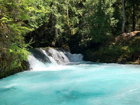
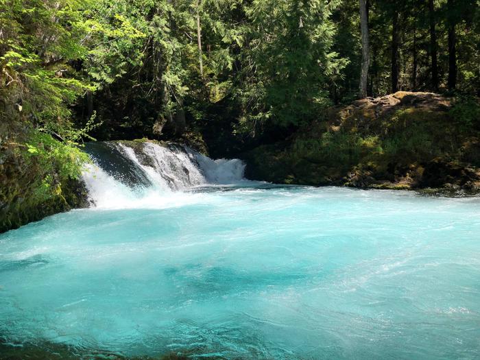
Willamette National Forest
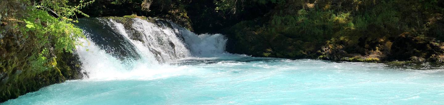
The Willamette National Forest offers a stunning choice of year round recreation for day-trippers and vacationers alike from hiking, camping, fishing or skiing in the Cascade Mountains to picnicking or rafting along one of our scenic rivers. Seven major volcanic peaks rise within the Forest's Wilderness areas: Mt. Jefferson, Three Fingered Jack, Mt. Washington, the Three Sisters, and Diamond Peak.
Visitor Map
Use our recreation map to find activities to enjoy your time in the Willamette National Forest.
- Explore the Detroit Ranger District (Hwy 22)
- Explore the Sweet Home Ranger District (Hwy 20)
- Explore the McKenzie River Ranger District (Hwy 126)
- Explore the Middle Fork Ranger District (Hwy 58)
The recreation conditions report Displays area conditions for all camping and cabins on the Willamette National Forest as well as popular recreation sites and sno-park conditions (in the winter months). Many campgrounds and cabins can be reserved online at www.recreation.gov or phone 1.877.444.6777. For a full list of campgrounds north to south by ranger district click here.
RecAreaDirections
Open with Google Map
Misc
| Stay Limit | |
| Reservable | false |
| Keywords | |
| Map Link | |
| Contact Phone | |
| Contact Email |
Permits info
Facilities
Alder Springs Campground
List of CampsitesOverview
This location is available on a first-come, first-served basis only. Visitors are required to physically arrive at the campground to purchase and claim a site. Once on-site, you may be able to pay for your campsite(s) by scanning a QR code using the Recreation.gov mobile app, and the Scan and Pay feature.
If this option is available, you will need to first download the free Recreation.gov mobile app https://www.recreation.gov/mobile-app prior to your arrival as some remote areas have limited or no cellular service.
Bedrock Campground Campground
List of CampsitesOverview
This location is available on a first-come, first-served basis only. Visitors are required to physically arrive at the campground to purchase and claim a site. Once on-site, you may be able to pay for your campsite(s) by scanning a QR code using the Recreation.gov mobile app, and the Scan and Pay feature.
If this option is available, you will need to first download the free Recreation.gov mobile app https://www.recreation.gov/mobile-app prior to your arrival as some remote areas have limited or no cellular service.
Big Meadows Horse Camp Campground
List of CampsitesOverview
This location is available on a first-come, first-served basis only. Visitors are required to physically arrive at the campground to purchase and claim a site. Once on-site, you may be able to pay for your campsite(s) by scanning a QR code using the Recreation.gov mobile app, and the Scan and Pay feature.
If this option is available, you will need to first download the free Recreation.gov mobile app https://www.recreation.gov/mobile-app prior to your arrival as some remote areas have limited or no cellular service.
Big Pool Campground
List of CampsitesOverview
This location is available on a first-come, first-served basis only. Visitors are required to physically arrive at the campground to purchase and claim a site. Once on-site, you may be able to pay for your campsite(s) by scanning a QR code using the Recreation.gov mobile app, and the Scan and Pay feature.
If this option is available, you will need to first download the free Recreation.gov mobile app https://www.recreation.gov/mobile-app prior to your arrival as some remote areas have limited or no cellular service.
Blair Lake Campground Campground
List of CampsitesOverview
This location is available on a first-come, first-served basis only. Visitors are required to physically arrive at the campground to purchase and claim a site. Once on-site, you may be able to pay for your campsite(s) by scanning a QR code using the Recreation.gov mobile app, and the Scan and Pay feature.
If this option is available, you will need to first download the free Recreation.gov mobile app https://www.recreation.gov/mobile-app prior to your arrival as some remote areas have limited or no cellular service.
Located in a beautiful high-elevation alpine setting, this small 7 site tent-only campground is situated along the north shore of Blair Lake. Four campsites are walk-in only, the remaining three sites are accessible by vehicle. Expect heavy weekend use during the summer and note that the small, unimproved parking area is better suited for smaller vehicles.
Blair Lake, 35 acres in size and 20 feet deep, supports a population of brook and rainbow trout and is stocked regularly. The surrounding landscape provides an impressive wildflower display in early summer and tasty huckleberries in late summer/early autumn. The historic Blair Lake Trail begins nearby, enticing hikers, equestrians, and off-road cyclists into the high elevation prairies and forests.
Blue Pool Campground
List of CampsitesOverview
This location is available on a first-come, first-served basis only. Visitors are required to physically arrive at the campground to purchase and claim a site. Once on-site, you may be able to pay for your campsite(s) by scanning a QR code using the Recreation.gov mobile app, and the Scan and Pay feature.
If this option is available, you will need to first download the free Recreation.gov mobile app https://www.recreation.gov/mobile-app prior to your arrival as some remote areas have limited or no cellular service.
Broken Bowl Campground
List of CampsitesOverview
This location is available on a first-come, first-served basis only. Visitors are required to physically arrive at the campground to purchase and claim a site. Once on-site, you may be able to pay for your campsite(s) by scanning a QR code using the Recreation.gov mobile app, and the Scan and Pay feature.
If this option is available, you will need to first download the free Recreation.gov mobile app https://www.recreation.gov/mobile-app prior to your arrival as some remote areas have limited or no cellular service.
Campers Flat Campground
List of CampsitesOverview
This location is available on a first-come, first-served basis only. Visitors are required to physically arrive at the campground to purchase and claim a site. Once on-site, you may be able to pay for your campsite(s) by scanning a QR code using the Recreation.gov mobile app, and the Scan and Pay feature.
If this option is available, you will need to first download the free Recreation.gov mobile app https://www.recreation.gov/mobile-app prior to your arrival as some remote areas have limited or no cellular service.
Dolly Varden Campground
List of CampsitesOverview
This location is available on a first-come, first-served basis only. Visitors are required to physically arrive at the campground to purchase and claim a site. Once on-site, you may be able to pay for your campsite(s) by scanning a QR code using the Recreation.gov mobile app, and the Scan and Pay feature.
If this option is available, you will need to first download the free Recreation.gov mobile app https://www.recreation.gov/mobile-app prior to your arrival as some remote areas have limited or no cellular service.
Elk Lake (OR) Campground
List of CampsitesOverview
This location is available on a first-come, first-served basis only. Visitors are required to physically arrive at the campground to purchase and claim a site. Once on-site, you may be able to pay for your campsite(s) by scanning a QR code using the Recreation.gov mobile app, and the Scan and Pay feature.
If this option is available, you will need to first download the free Recreation.gov mobile app https://www.recreation.gov/mobile-app prior to your arrival as some remote areas have limited or no cellular service.
Gold Lake Campground (OR) Campground
List of CampsitesOverview
This location is available on a first-come, first-served basis only. Visitors are required to physically arrive at the campground to purchase and claim a site. Once on-site, you may be able to pay for your campsite(s) by scanning a QR code using the Recreation.gov mobile app, and the Scan and Pay feature.
If this option is available, you will need to first download the free Recreation.gov mobile app https://www.recreation.gov/mobile-app prior to your arrival as some remote areas have limited or no cellular service.
Indigo Springs Campground
List of CampsitesOverview
This location is available on a first-come, first-served basis only. Visitors are required to physically arrive at the campground to purchase and claim a site. Once on-site, you may be able to pay for your campsite(s) by scanning a QR code using the Recreation.gov mobile app, and the Scan and Pay feature.
If this option is available, you will need to first download the free Recreation.gov mobile app https://www.recreation.gov/mobile-app prior to your arrival as some remote areas have limited or no cellular service.
Kiahanie Campground
List of CampsitesOverview
This location is available on a first-come, first-served basis only. Visitors are required to physically arrive at the campground to purchase and claim a site. Once on-site, you may be able to pay for your campsite(s) by scanning a QR code using the Recreation.gov mobile app, and the Scan and Pay feature.
If this option is available, you will need to first download the free Recreation.gov mobile app https://www.recreation.gov/mobile-app prior to your arrival as some remote areas have limited or no cellular service.
Lost Lake (OR) Campground
List of CampsitesOverview
This location is available on a first-come, first-served basis only. Visitors are required to physically arrive at the campground to purchase and claim a site. Once on-site, you may be able to pay for your campsite(s) by scanning a QR code using the Recreation.gov mobile app, and the Scan and Pay feature.
If this option is available, you will need to first download the free Recreation.gov mobile app https://www.recreation.gov/mobile-app prior to your arrival as some remote areas have limited or no cellular service.
Piety Island Campground
List of CampsitesOverview
This location is available on a first-come, first-served basis only. Visitors are required to physically arrive at the campground to purchase and claim a site. Once on-site, you may be able to pay for your campsite(s) by scanning a QR code using the Recreation.gov mobile app, and the Scan and Pay feature.
If this option is available, you will need to first download the free Recreation.gov mobile app https://www.recreation.gov/mobile-app prior to your arrival as some remote areas have limited or no cellular service.
Puma Campground
List of CampsitesOverview
This location is available on a first-come, first-served basis only. Visitors are required to physically arrive at the campground to purchase and claim a site. Once on-site, you may be able to pay for your campsite(s) by scanning a QR code using the Recreation.gov mobile app, and the Scan and Pay feature.
If this option is available, you will need to first download the free Recreation.gov mobile app https://www.recreation.gov/mobile-app prior to your arrival as some remote areas have limited or no cellular service.
Sacandaga Campground
List of CampsitesOverview
This location is available on a first-come, first-served basis only. Visitors are required to physically arrive at the campground to purchase and claim a site. Once on-site, you may be able to pay for your campsite(s) by scanning a QR code using the Recreation.gov mobile app, and the Scan and Pay feature.
If this option is available, you will need to first download the free Recreation.gov mobile app https://www.recreation.gov/mobile-app prior to your arrival as some remote areas have limited or no cellular service.
Salmon Creek Falls Campground
List of CampsitesOverview
This location is available on a first-come, first-served basis only. Visitors are required to physically arrive at the campground to purchase and claim a site. Once on-site, you may be able to pay for your campsite(s) by scanning a QR code using the Recreation.gov mobile app, and the Scan and Pay feature.
If this option is available, you will need to first download the free Recreation.gov mobile app https://www.recreation.gov/mobile-app prior to your arrival as some remote areas have limited or no cellular service.
Sand Prairie Campground Campground
List of CampsitesOverview
This location is available on a first-come, first-served basis only. Visitors are required to physically arrive at the campground to purchase and claim a site. Once on-site, you may be able to pay for your campsite(s) by scanning a QR code using the Recreation.gov mobile app, and the Scan and Pay feature.
If this option is available, you will need to first download the free Recreation.gov mobile app https://www.recreation.gov/mobile-app prior to your arrival as some remote areas have limited or no cellular service.
Scott Lake Campground
List of CampsitesOverview
This location is available on a first-come, first-served basis only. Visitors are required to physically arrive at the campground to purchase and claim a site. Once on-site, you may be able to pay for your campsite(s) by scanning a QR code using the Recreation.gov mobile app, and the Scan and Pay feature.
If this option is available, you will need to first download the free Recreation.gov mobile app https://www.recreation.gov/mobile-app prior to your arrival as some remote areas have limited or no cellular service.
Secret Campground
List of CampsitesOverview
This location is available on a first-come, first-served basis only. Visitors are required to physically arrive at the campground to purchase and claim a site. Once on-site, you may be able to pay for your campsite(s) by scanning a QR code using the Recreation.gov mobile app, and the Scan and Pay feature.
If this option is available, you will need to first download the free Recreation.gov mobile app https://www.recreation.gov/mobile-app prior to your arrival as some remote areas have limited or no cellular service.
Sevenmile Campground
List of CampsitesOverview
This location is available on a first-come, first-served basis only. Visitors are required to physically arrive at the campground to purchase and claim a site. Once on-site, you may be able to pay for your campsite(s) by scanning a QR code using the Recreation.gov mobile app, and the Scan and Pay feature.
If this option is available, you will need to first download the free Recreation.gov mobile app https://www.recreation.gov/mobile-app prior to your arrival as some remote areas have limited or no cellular service.
Shady Cove Campground
List of CampsitesOverview
This location is available on a first-come, first-served basis only. Visitors are required to physically arrive at the campground to purchase and claim a site. Once on-site, you may be able to pay for your campsite(s) by scanning a QR code using the Recreation.gov mobile app, and the Scan and Pay feature.
If this option is available, you will need to first download the free Recreation.gov mobile app https://www.recreation.gov/mobile-app prior to your arrival as some remote areas have limited or no cellular service.
Skookum Creek Campground Campground
List of CampsitesOverview
This location is available on a first-come, first-served basis only. Visitors are required to physically arrive at the campground to purchase and claim a site. Once on-site, you may be able to pay for your campsite(s) by scanning a QR code using the Recreation.gov mobile app, and the Scan and Pay feature.
If this option is available, you will need to first download the free Recreation.gov mobile app https://www.recreation.gov/mobile-app prior to your arrival as some remote areas have limited or no cellular service.
ICE CAP CAMPGROUND Campground
List of CampsitesOverview
Ice Cap Campground is 17 miles east of the McKenzie River Ranger Station on Hwy 126. It sits on a bench above the McKenzie River and Carmen Reservoir. However, the river is not visible from the campground. It is shaded by big, beautiful conifers.Recreation
The McKenzie River National Recreation Trail is a hiking and biking destination. The McKenzie Wild & Scenic River is well known for boating and fishing as are Carmen Reservoir, Fish Lake and Clear Lake. There is a 3 mile loop trail to Koosah Falls and Sahalie Falls.Facilities
Ice Cap offers 22 campsites with 9 that are walk-in tent sites. The other 13 can accommodate either tents or RVs. Each site has a fire ring and picnic table. There are vault toilets, firewood for sale, and a host onsite.Natural Features
Located in central Oregon in the Willamette National Forest along the McKenzie Pass-Santiam Pass National Scenic Byway. Koosah and Sahalie Falls are readily accessible from the campground.Nearby Attractions
This area of the Willamette National Forest is a destination spot for hiking, biking, fishing, and water sports. A boat ramp and lake access are within one mile, and hot springs, river access and a non-motorized boat ramp are within ten miles. Visitors also enjoy the views along the National Scenic Byway.COUGAR CROSSING CAMPGROUND Campground
List of CampsitesOverview
Cougar Crossing Campground is located on Forest Road 19 about 10 miles south of the Hwy 126 junction.Recreation
Hiking is popular as the Three Sisters Wilderness, French Pete Trail, Box Canyon Trail, Indian Ridge Lookout, and Cougar Recreation Area are nearby. Many folks also come to the area to bathe at Terwilliger Hot Springs (clothing optional). There is creek and river access, and opportunities for lake recreation. When the reservoir lake level is high, there is a primitive boat launch across from the campground available for use.Facilities
Cougar Crossing offers 11 sites that can accommodate either RV or tent camping. Vault toilets are provided. There is firewood for sale. The interior roads and spurs are gravel. There is no drinking water.Natural Features
Nestled in among a mix of conifers, the campground rests beside the South Fork of the McKenzie River and the south end of Cougar Reservoir. It is the closest campground to Terwilliger Hot Springs.Nearby Attractions
The campground and nearby Terwilliger Hot Springs have a colorful history and attract many visitors year round. There is plenty to explore at nearby trails and Three Sisters Wilderness.LOOKOUT CAMPGROUND AND BOAT LAUNCH - WILLAMETTE Campground
List of CampsitesOverview
Lookout Boat Launch and Campground is found on Blue River Reservoir. The campground includes a day use picnic area, a boat launch, floating dock, and a day use/overflow parking area. It is located on a beautiful open meadow with plenty of sunshine.Recreation
Fishing, boating, swimming, and water skiing on Blue River Reservoir draw campers here. There is hiking on Buck Mountain Trail and Lookout Creek Old Growth Trail. Sightseeing is popular on the West Cascades National Scenic Byway.Facilities
Lookout Campground is popular for group camping, as there are no designated sites. Drinking water, vault toilets, and firewood for sale are provided. There is a host onsite. While the day use parking and boat launch area is paved, the campground side is gravel.Natural Features
The campground sits on the northeastern shore of Blue River Reservoir and can be accessed by driving the West Cascades National Scenic Byway. It is located in the Willamette National Forest on the western slopes of the Cascade Mountains.Nearby Attractions
Come for water play or fishing at Blue River Reservoir or for exploring the nearby trails and Scenic Byway. Hot springs are loctated within 10 miles.ROARING RIVER (GROUP) Campground
List of CampsitesOverview
Campers at Roaring River Group Campground enjoy the soothing sounds of the aptly named Roaring River flowing past their campsites. The campground is tucked in a wooded setting in Willamette National Forest and can accommodate up to 50 overnight visitors.Fishing and hiking are a few of the best ways to spend the day here. The nearby Three Sisters Wilderness offers plenty of trails to explore.
Recreation
The Box Canyon Trail area is nearby, providing excellent hiking routes like the McBee Trail and the Roaring Ridge Trail. The Roaring Ridge Trail passes through Douglas fir forests with views of the South Fork of the McKenzie River. Mountain biking, fishing and wildlife viewing are popular activities here. Bird sightings may include osprey, great blue herons and bald eagles.Facilities
Roaring River provides picnic tables, dumpsters, vault toilets and campfire rings. No water is provided so campers are expected to bring their own. Parking fits up to 10 vehicles.Natural Features
The group site is just a few feet from the river on the east bank, among Douglas fir, maple and alder. The Willamette National Forest stretches for 110 miles with varied landscapes of high mountains, narrow canyons, cascading streams and wooded slopes.Nearby Attractions
The Three Sisters Wilderness Area offers 260 miles of hiking trail through 286,708 acres of wild, incredible mountains and meadows. There is also access to non-wilderness hiking and mountain bike trails within 10 miles.HORSE CREEK GROUP CAMPGROUND Campground
List of CampsitesOverview
Horse Creek Group Campground is located on the banks of Horse Creek. The rushing water and tall Douglas fir trees offer a cool, shady spot to enjoy the outdoors. A picnic area offers a great spot for grilling and group gatherings.Recreation
Fishing in Horse Creek is an enjoyable pastime. The McKenzie River National Recreation Trailhead is nearby, offering fun-filled hiking and biking opportunities. The 26-mile trail boasts wonderful scenery along the river, and is an easy hike for all ages. There are also numerous developed boat launches that provide access to the McKenzie River.Facilities
Horse Creek accommodates up to 100 campers and 23 vehicles. The campground comes with drinking water, picnic tables, vault toilets and campfire rings. Visitors need to bring their own firewood.Natural Features
The campground sits along Horse Creek among Douglas fir and Western Red Cedar. The creek flows into the McKenzie River, a 90-mile tributary that transports snowmelt from the Cascade Range to the Willamette Valley.Set along the western slopes of the Cascade Mountains, gorgeous, lush mountain landscapes are found in every direction.
Nearby Attractions
Cougar Reservoir is about 10 miles southwest and boasts excellent boating opportunities.MCKENZIE BRIDGE Campground
List of CampsitesOverview
McKenzie Bridge Campground is located an hour east of Eugene, Oregon. It rests in the shade of a towering grove of Douglas fir and Western red cedar trees along the banks of the McKenzie River.The campground is small and pleasant, providing an ideal atmosphere for relaxation, fishing and bird watching. Feathered residents of the river include osprey, great blue herons and bald eagles.
Recreation
At the campground, the river provides catch-and-release fishing for trout and steelhead. Whitewater kayaking and rafting are also popular activities. A boat ramp is located on-site. The McKenzie River National Recreation Trail begins nearby, offering fun-filled hiking and biking opportunities. The 26-mile trail boasts wonderful scenery along the river and is an easy hike for all ages.Facilities
Campsites are nicely spaced and many have riverfront access. Vault toilets and drinking water are provided. Parking areas are gravel surfaced.Natural Features
McKenzie Bridge sits on the banks of the McKenzie River at an elevation of 1,200 feet. Rapids in various sections of the river are what make McKenzie one of Oregon's most popular rivers for whitewater rafting.McKenzie Bridge is part of the Willamette National Forest, which stretches for 110 miles along the western slopes of the Cascade Range.
Nearby Attractions
Restaurants and the Tokatee Golf Course are within a few miles of the campground.PARADISE IN OREGON Campground
List of CampsitesOverview
Paradise Campground is indeed a paradise for campers. Tucked within a lush, old-growth forest of Douglas fir and western red cedar, the area portrays a sub-tropical vibe along the banks of the McKenzie River, where catch-and-release trout and steelhead fishing is a popular activity, along with whitewater rafting and kayaking.Recreation
Rafters and kayakers live it up in the whitewater of the McKenzie River. A boat ramp is located on-site.The McKenzie River National Recreation Trail begins nearby, and is a favorite among hikers and mountain bikers.
Facilities
A number of sites face the river, while many others are tucked into the scenic forest. Flush toilets are dispersed throughout the campground and parking spurs are paved. Educational programs are provided at the amphitheater.Natural Features
Paradise sits on a bend of the river at an elevation of 1,600 feet. Ferns and other moisture loving plants cover the ground, and mosses drape the trees. The campground is in the heart of Willamette National Forest, which spans 1.6 million acres on the western slopes of the Cascade Range.Nearby Attractions
A golf course is located about 7 miles west of the campground.BIG LAKE Campground
List of CampsitesOverview
Big Lake Campground sits at its namesake lake along Santiam Pass, a 4,800-foot mountain pass through the Cascade Range in western Oregon.Campers enjoy views of the lake with the beautiful Mt. Washington as a backdrop.
Recreation
Water skiing, sailing and swimming are among the favorite activities at the lake. The Patjens Lakes Trail offers excellent hiking opportunities. The trail follows the western side of Big Lake, heads south into the Mt. Washington Wilderness, passes alongside the scenic Patjens Lakes, and then loops back to the campground.Facilities
Big Lake Campground offers 49 spacious campsites for tent or RV camping. Drinking water, vault toilets and a boat ramp are provided.Natural Features
Surrounded by Alpine fir, hemlock and lodge pole pine, the campground sits on the western side of the lake.Big Lake, at elevation 4,600 feet, is in the Willamette National Forest, which spans 1.6 million acres on the western slopes of the Cascade Mountains.
Nearby Attractions
Several hiking trails and OHV trails are in the area. Explore the Santiam Pass region on the McKenzie Pass - Santiam Pass National Scenic Byway that passes through 130 miles of lava fields, lakes and waterfalls.Cold Water Cove - Willamette NF (OR) Campground
List of CampsitesOverview
Cold Water Cove Campground offers stunning views of turquoise-colored Clear Lake and 3,000-year-old lava fields, making it an ideal location. On clear days, visitors can catch a glimpse of the Three Sisters and Mount Washington. Fishing, canoeing and boating are popular activities.Recreation
Clear Lake is popular for fishing, canoeing and boating. Anglers cast for brook, rainbow and cutthroat trout. Power boating is not permitted, which makes for calm waters. A boat ramp and fish cleaning station are located in the campground. Boat rentals are available at an adjacent resort. The McKenzie River National Recreation Trail passes through the campground and runs along Clear Lake. The trail stretches 26 miles and is open to hikers and mountain bikers.Facilities
The campground offers single and double-family campsites. Each site is equipped with a picnic table and campfire ring. Vault toilets, trash collection and drinking water are provided. No hookups are available. A general store and restaurant are located at the resort next door.Natural Features
The campground sits at the south end of the lake at an elevation of 3,100 feet. A mix of maple, alder and Douglas fir trees cover the area. Some sites have limited views of the lake, and all sites have privacy from neighboring campers. Cold Water Cove sits in the midsection of the Cascades mountain range.Nearby Attractions
The campground is near the Big Lake Trail Area, as well as Sahalie Falls and Koosah Falls. The falls are impressive sights, with foaming water gushing over two thick flows of ancient lava.LONGBOW ORGANIZATION GROUP Campground
List of CampsitesOverview
Longbow Organization Camp was built by the Civilian Conservation Corps in the 1930s. The historic campground provides a covered cooking area with a fireplace and six sleep shelters that face the beautiful South Santiam River.Recreation
Fishing and wading opportunities abound in the South Santiam River. Visitors interested in hiking can explore the Old Santiam Wagon Road. The historic trail was used to transport livestock east across the Cascade Mountains to central Oregon's grasslands.Facilities
Longbow includes six alpine shelters that sleep a total of 48 people. All shelters are along the river. There is a covered cooking area and an amphitheater that seats 75 people. Firewood is sold through Linn County Park staff.
Natural Features
The campground spans 10 acres on a bend of the South Santiam River. The river is fed by runoff from the Cascade Mountains and flows for 66 miles. The Menagerie Wilderness is located nearby. Elk can sometimes be seen in early May in an elk pasture one mile from Longbow.Nearby Attractions
For additional hiking options, head to the South Santiam and Gordon Lakes Trail Area.OLALLIE ON MCKENZIE HIGHWAY Campground
List of CampsitesOverview
Nestled on the banks of the McKenzie River and Olallie Creek, Olallie Campground provides a superb setting for a getaway into nature. The lower loop offers mesmerizing views of both the river and the creek while the upper loop is set further in the trees with many sites facing the creek. The McKenzie River is a tributary of the Willamette River that runs for 90 miles, flowing into the southernmost end of the Willamette Valley.Recreation
Fishing, rafting and swimming are three top activities in the river. A day use picnic area is also available at the campground. Nearby is the 26 mile McKenzie River National Recreation Trail, which provides access to world class mountain biking and hiking.Facilities
This campground has 16 sites divided into two loops along the eastern banks of the river by Olallie Creek. No electric hookups are available at the campground. Picnic tables, vault toilets and drinking water are among the amenities available. A camp host is on-site, and firewood is available for purchase.Natural Features
Olallie Campground is located in the midsection of the Cascades mountain range in western Oregon. All campgrounds are nicely shaded by Douglas fir, maple and alder. The Willamette National Forest stretches for 110 miles with varied landscapes of high mountains, narrow canyons, cascading streams, and wooded slopes.PACKARD CREEK Campground
List of CampsitesOverview
Packard Creek is a popular campground on the western side of Hills Creek Reservoir. The family-friendly destination offers a picturesque setting among tall trees, with views of the lake beyond. Most of the campground is accessible.Recreation
Larison Creek Trail is excellent for mountain biking, horseback riding and hiking. It meanders along Larison Cove and Larison Creek, through lush vegetation of hemlock, Douglas fir and red cedar.Visitors also enjoy boating, swimming and fishing. Anglers often catch catfish, blue gill, crappie and coho salmon. A fishing dock, swimming area and boat ramp can be found in the day use area.
Facilities
There are 36 standard campsites, 14 are reservable. Each campsite is equipped with a picnic table and a campfire ring. There is also a reservable group campground, which accommodates up to 80 people, has a large picnic shelter and open space for tents. Some sites have individual boat docks as well.Natural Features
The campground is situated on a large flat beside Hills Creek Reservoir. The lake, hugged by a diverse mix of vegetation, covers 2,735 acres with 44 miles of shoreline in Willamette National Forest.Nearby Attractions
The campground is near Oakridge, Oregon, once a railroad boomtown at the turn of the 20th century. Other noteworthy places include many hot springs found within the forest.TIMBER BUTTE CABIN Campground
List of CampsitesOverview
Timber Butte Lookout is located in the Fall Creek area of the Willamette National Forest at an elevation of 3,650 feet 19 miles from Lowell, Oregon. The cabin is open from mid-April through late October, offering the chance to enjoy beautiful scenery and a variety of recreational activities. The lookout was constructed in 2005 as a replica of the L-4 gabled-style lookout with wooden catwalk commonly built in this region in the 1930s. It was built through volunteer efforts with a $10,000 grant from Lane County and other contributions by individuals and organizations. The cabin can be accessed by car, but guests should expect to walk about 300 feet uphill from their parking spot. A high-clearance vehicle is recommended.Recreation
The lookout is located near the Fall Creek Trail Area. Several hiking trails can be accessed from this area, including the Fall Creek National Recreation Trail, which also offers opportunities for fishing and picnicking. Swimming holes can also be found along this trail.Hunting is another popular activity in this area.
Facilities
The 14x14-ft. cabin is encircled by a catwalk. It sits slightly off the ground and is accessed by a ramp. The cabin accommodates 4 people and contains a double bed with sleeping pad, a propane heating stove, fire extinguisher, broom and dustpan. A 3-burner propane cook top is located on the deck. Propane is provided. Dishes and cookware are available. A picnic table and fire ring are located in a nearby group of trees, and a vault toilet is located about 300 feet away. No drinking water or electricity is provided. Guests must bring their own supply of drinking water. Items such as bedding, lanterns or flashlights, matches, extra toilet paper, first aid supplies, trash bags, dish soap, towels and an ice chest are not available. Guests are expected to pack out their trash and clean the cabin before leaving.Natural Features
The lookout offers panoramic views of the Cascade Mountains and the surrounding evergreen forest. On clear days, guests may see Mount Jefferson and the peaks of the Three Sisters. Willamette National Forest offers prime habitat for such species as Roosevelt elk, black bear, bald eagles, black tail deer and bobcats, among other wildlife.Nearby Attractions
Guests can explore up to 20 historic covered bridges in nearby Lane County by car. Within 10 miles there is creek access, fishing, swimming, and hiking.FOX CREEK GROUP CAMP Campground
List of CampsitesOverview
Fox Creek Group Camp is situated in a large, open area surrounded by dense forest near the point where Fox Creek flows into the Breitenbush River. Campers are sure to enjoy the variety of recreation like hiking, fishing and swimming. The group site accommodates tent campers plus RVs and trailers of any size.Recreation
Fox Creek is a central access point to miles of scenic hiking trails. Willamette National Forest boasts 1,700 miles of trails, many of which trek through wilderness areas like the nearby Mount Jefferson Wilderness.Campers can fish and swim in the Breitenbush River. Rainbow trout is the most common catch for anglers.
Facilities
No drinking water is available at this site. The group site caters to groups of up to 75 guests with ample parking. It is equipped with an accessible vault toilet, dumpster, campfire rings and picnic tables.Natural Features
The campground is a short walk from the Breitenbush River, a tributary of Oregon's North Santiam River, at an elevation of 1,700 feet. The river's clean waters flow from short forks of snow melt in the Mount Jefferson Wilderness.The Willamette National Forest stretches for 110 miles along the western slopes of the Cascade Range in western Oregon. The varied landscape of high mountains, narrow canyons, cascading streams, and wooded slopes offer excellent sightseeing and recreation opportunities.
Nearby Attractions
Head to Detroit Lake for a variety of activities including power boating, water skiing, kayaking and canoeing. Within 10 miles there are also opportunities for off-highway vehicle recreation, hunting, hiking, backpacking, scenic driving, and soaking in hot springs.RIVERSIDE AT DETROIT (Willamette National Forest, OR) Campground
List of CampsitesOverview
Riverside at Detroit Campground is an excellent outdoor retreat designed for campers more interested in a remote experience. Guests are greeted with grand, mature cedars and Douglas fir trees as they drive into the campground.The Coffin Mountain Trail Area is located nearby, with splendid trails to explore like the Coffin Lookout and Bugaboo Ridge Trails.
Recreation
Anglers enjoy fishing for rainbow trout on the river. Among the many options for hiking and biking trails, the Mt. Jefferson-Pamelia Lake Trail Area is bound to please all types. Hikers looking for a challenging trail will enjoy the Minto Mountain Trail.Facilities
This campground has 37 sites, 20 are reservable. The campground is comprised of two sections. The southeast (upriver) section has more secluded sites on a bluff overlooking the river. Northwest (downriver) sites have partial shade and a more open setting. Drinking water spigots can be found throughout the campground. Waste gray water disposal sites are provided. Firewood is available for sale on-site.Natural Features
Riverside is located along the North Fork Santiam River at an elevation of 2,400 feet. Surrounding vegetation includes hemlock, rhododendron and fern, among the towering conifers.The campground is in the North Santiam Travel Corridor of the Willamette National Forest. The forest covers 1.6 million acres on the western slopes of the Cascade Range.
Nearby Attractions
The Marion Forks Fish Hatchery, along Marion and Horn Creeks, is an interesting place to visit. Here, visitors can see rainbow trout, summer steelhead and spring chinook being harvested.CLEATOR BEND Campground
List of CampsitesOverview
Cleator Bend Group Campground, located on a bend of the Breitenbush River, is a popular destination for camping. The group area provides an ideal base camp for fishing, hiking, biking and more.Recreation
The river is a popular spot for wading, swimming and rainbow trout fishing.Facilities
Cleator Bend is a group campground on the northern banks of the river. A vault toilet is located in the middle of the camping loop and two water spigots are provided. Trash collection, campfire rings and picnic tables are provided. The capacity for the group site is 45 guests.Natural Features
The Breitenbush River is a tributary of the North Santiam River. The clean waters flow from snow melt in the Mount Jefferson Wilderness. The campground lies in the Willamette National Forest, which stretches 110 miles along the western slopes of the Cascade Range.Nearby Attractions
The South Breitenbush Gorge Trail is three miles from the campground. Here, hikers can view the river passing through basalt narrows. During the hike, look for a log footbridge that crosses Roaring Creek's cascading waters.HOUSE ROCK CAMPGROUND Campground
List of CampsitesOverview
House Rock Campground is perched on the confluence of Sheep Creek and the South Santiam River in an old growth forest grove.Campers enjoy hiking the House Rock Trail, which starts at the day-use area. Part of the trail shares paths with the historic Santiam Wagon Road, a trail used to transport livestock east across the Cascade Mountains to central Oregon's grasslands.
Recreation
Swimming is popular, especially because many sites have riverfront access to shallow swimming areas. Anglers can cast for native cutthroat trout.In addition to the House Rock Trail, hikers have access to a variety of other trails in the Tombstone Pass Area, like the Iron Mountain Trail.
Facilities
The campground road and parking spurs are composed of packed dirt and rock. The double-loop area comes with accessible vault toilets and drinking water from hand pumps. Picnic tables, campfire rings and grills are at each site. Firewood is sold through the Linn County Park staff.
Natural Features
House Rock Campground is perched on the confluence of Sheep Creek and the South Santiam River in an old growth grove.The river is a 66-mile tributary of the Santiam River that is fed by snowmelt from the Cascade Mountains.
Nearby Attractions
Visit Foster Lake or Green Peter Lake for lake fishing and boating.TROUT CREEK CAMPGROUND Campground
List of CampsitesOverview
Trout Creek Campground is a fun, family campground situated along the South Santiam River, 20 miles east of the town of Sweet Home, Oregon. Many sites are right on the river, tucked under the cool shade of Douglas-fir and Hemlock trees.The campground was built by the Civilian Conservation Corps (CCC) in the 1930s and includes a welcoming day use shelter with a fireplace and five pull-through RV parking loops and a mix of standard parking spurs. Plenty of river activities and hiking opportunities await.
Recreation
Wading and fishing are popular in the river and hikers enjoy easy access to the 2.8-mile Trout Creek Trail and the short Walton Ranch Interpretive Trail.The Menagerie Wilderness can be accessed from the Trout Creek Trail, so hikers and backpackers can explore the area's extensive system of trails.
Facilities
Drinking water is from a hand pump well. There are three vault restrooms available in the park. Parking spurs are gravel and roads are paved. It is recommended that you bring your own campfire wood. Firewood is available, for purchase, at River Bend County Park, 45931 Santiam Hwy., Foster, Oregon 97345.
Natural Features
Trout Creek is tucked in a heavily wooded landscape with lichen and moss-draped Alder, Douglas fir, Hemlock, and Maple trees. Campsites are well-shaded and full of ferns and similar sub-tropical greenery. Many sites stretch along the South Santiam River, a 66-mile tributary of the Santiam River.
Nearby Attractions
Visit the old Santiam Wagon Road, a historic trail used to transport livestock east across the Cascade Mountains to central Oregon's grasslands.In August, the nearby Oregon Bluegrass Jamboree is a hit.
BREITENBUSH CAMPGROUND Campground
List of CampsitesOverview
Breitenbush Campground is nestled along the banks of its namesake river in the forests of western Oregon. The peaceful flow of the river can be heard throughout the campground, providing a peaceful getaway for campers.Recreation
Wading and fishing are popular activities in the Breitenbush River, and rainbow trout is the most common catch for anglers.The Willamette National Forest has about 1,700 miles of trail. While many are in wilderness areas, a number of trails are low-elevation, easy-access trails for year-round hiking.
Facilities
This campground has 29 sites, 18 are reservable, and all have picnic tables, grills and easy access to the vault toilets. Drinking water spigots are spread throughout the campground. Most campsites offer sweeping views of the river.Natural Features
The campground lies in the Willamette National Forest, which stretches for 110 miles along the western slopes of the Cascade Range. The varied landscape of high mountains, narrow canyons, cascading streams and wooded slopes offer varied recreational opportunities for visitors. The Breitenbush River is a tributary of the North Santiam River, and its clean waters flow from snow melt in the Mount Jefferson Wilderness. A variety of plants and foliage separate the spacious campsites and provide privacy from other sites.Nearby Attractions
Detroit Lake provides plenty of opportunity for water recreation like boating, water skiing and kayaking.SLIDE CREEK Campground
List of CampsitesOverview
Slide Creek Campground is a unique camping destination just 50 miles from Eugene, Oregon. Located on the east bank of the Cougar Reservoir, it is known for handy access to boating and many water activities. It is also near Terwilliger Hot Springs, a pristine area with 5 soaking pools fed by the Rider Creek waterfall.Recreation
Activities on the reservoir include water skiing, swimming, fishing and canoeing. Anglers might catch some quality rainbow trout. The campground is close to a large network of hiking trails in the Olallie Trail Area. Half of the trails are open to biking as well.Facilities
Both campground and the day use area guests have access to drinking water, vault toilets, a boat ramp, ample parking and a swimming beach. A separate parking lot is available for boat trailers. The facility has 15 campsites that can accommodate tents, trailers or RVs and come equipped with campfire rings and picnic tables.Natural Features
The Willamette National Forest stretches for 110 miles with varied landscapes of high mountains, narrow canyons, cascading streams, and wooded slopes. Native wildlife includes Roosevelt elk, black bear, bald eagles, black tail deer and bobcats. Cougar Reservoir sits at 1,700 feet in elevation and is an estimated 1,280 acres. Some campsites have views of Cougar Reservoir and all sites are an easy walk to the swimming area.DELTA Campground
List of CampsitesOverview
Known for its access to rafting and drift boat fishing on the McKenzie River, Delta campground, located along a portion of the West Cascades National Scenic Byway, is one of the largest and most scenic campgrounds on the McKenzie District. Access to the river, hiking and mountain biking trails are nearby. Reservations are available May through Mid-September, they can be made at least six months in advance, but must be made at least 4 days prior to your intended arrival date.Recreation
Cougar Reservoir and Terwilliger Hot Springs make this campground a great spot for camping and exploring the area. Visitors can also enjoy a short botanical walk on the Delta Old Growth Nature Trail. A Day Use area and amphitheater are also available at the campground.Nearby Attractions
There is a non-motorized boat launch within one mile. Within ten miles there is a motorized boat launch and access to flat water. Hiking and biking trails and Terwilliger Hot Springs are also within ten miles.MONA Campground
List of CampsitesOverview
Known for fishing, boating, canoeing and other water sports, Mona campground is located on the northwest shore of Blue River Reservoir. The campground is situated on a long, narrow strip of mixed conifers along the shore, the thick vegetation secludes each campsite, allowing for privacy. Slopes of mixed conifers and other trees surround the area.Reservations are available May through mid-September. They can be made up to six months in advance, but must be made at least four days prior to your intended arrival date.
Recreation
Fishing, boating, swimming, and water skiing on Blue River Reservoir draw campers here. There is hiking on Buck Mountain Trail and Lookout Creek Old Growth Trail. Sightseeing is popular on the West Cascades National Scenic Byway.Facilities
Mona Campground is popular for water play and fishing on Blue River Reservoir. There are 20 single and two double sites with tables and fire rings. Drinking water, vault toilets, and firewood for sale are provided. There is a host onsite. The campground road and parking spurs are paved, with mostly flat sites that accommodate either tents or trailers/RVs.Natural Features
The campground sits on the northeastern shore of Blue River Reservoir and can be accessed by driving the West Cascades National Scenic Byway. It is located in the Willamette National Forest on the western slopes of the Cascade Mountains.Nearby Attractions
Come for water play or fishing at Blue River Reservoir or for exploring the nearby trails and Scenic Byway.NORTH WALDO Campground
List of CampsitesOverview
Waldo Lake is one of the largest natural lakes in Oregon. It offers a uniquely peaceful setting on the water and along remote shorelines, surrounded by forests of Douglas fir and mountain hemlock. Recreation in the area is abundant with the lake an ideal location for water activities like sailing, canoeing and swimming.Recreation
Waldo Lake is circled by the Jim Weaver Loop, 20 miles of trail for hiking and biking. Bikes are allowed on the trails, but not in the nearby Waldo Lake Wilderness. There is also easy access to the Pacific Crest Trail and North Waldo is also a popular starting point for many wilderness trails and lakes, most notably the Rigdon, Wahanna and Torrey Lakes. There is a 1-mile Shoreline Trail between North Waldo Campground and Islet Campground which provides a short and pleasant hike along the lakeshore.Facilities
North Waldo is the most popular of the Waldo Lake Campgrounds. There are 58 sites with fire rings and tables, 34 are reservable. The boat launch is somewhat deeper than the others on the lake, which is more accommodating for large sailboats. The drier environment supports fewer mosquitoes, but they are still plentiful in season. This facility is operated by American Land & Leisure. We appreciate hearing from you. Comment cards are available from campground hosts or online at www.americanll.com.Natural Features
Situated high on the western slopes of the Oregon Cascades at 5,400 feet in elevation, Waldo Lake is one of the purest lakes in Oregon (9.8 square miles with a maximum depth of 427 feet). It has no permanent inlet to bring nutrients into the lake for plant growth. The lack of plant life contributes to its purity, allowing you to see to depths of 120 feet on a calm day.SWEET HOME NATURE AND HERITAGE TOURS Ticket Facility
Overview:
Come explore the beautiful Sweet Home Ranger District of the Willamette National Forest! Led by professionals, the Sweet Home Nature and Heritage Tours offer incredible opportunities to learn about the plants, animals, geology and cultural history of the Sweet Home area, located on the edges of the Willamette Valley and within the spectacular Cascade Mountains. Sweet Home Nature and Heritage Tours will take you to the out-of-the-way spots with a friendly group to explore, learn and have a wonderful time while coming to appreciate why the Sweet Home area is such a special place.Whether you're a budding naturalist or a long-time explorer of Pacific Northwest, Sweet Home Nature and Heritage Tours will be an experience you will long remember.
Most day tour fees are $10.00 per person and $5.00 with a Senior or Access Pass; request for refunds must be made at least 2 weeks prior to the date of the tour. Pre-registration is required for all tours and they fill up quickly.
All hikes/tours meet at the Sweet Home Ranger District Office and travel to the forest where the hike/tour begins. A restroom is available at the office, as well as maps and other small souvenirs. Sweet Home is a full service community with restaurants, cafes and gas stations.
Quick List of Hikes and Days Offered. Click on Tour List for more information.
- May 05, 2018 - General Outdoor Preparedness 01
- June 08, 2018 - Cascadia Cave
- June 13, 2018 - U.S. Capitol Christmas Tree Ornament Making
- July 06, 2018 - Iron Mountain / Cone Peak
- July 13, 2018 - Browder Ridge
- July 20, 2018 - Echo Basin
- August 03, 2018 - Gordon Meadows
- August 10, 2018 - Big Tree Expedition
- August 15, 2018 - CCC Annual Picnic
- August 17, 2018 - Streamside Rockhounding
- August 24, 2018 - Huckleberry haven
- August 31, 2018 - Mountain Biking with the Ranger
- September 07, 2018 - Horseback Riding with the Ranger
- September 14, 2018 - Cascadia Cave
- September 14, 2018 - Paddle Board / Kayak Daly Lake
- September 15, 2018 - General Outdoor Preparedness 01
- October 19, 2018 - Fall Edible Mushrooms
- October 26, 2018 - Edible Mushroom Hike and Cooking Demonstration
- December 01, 2018 - Wreath Making and Holiday Decor
HOOVER CAMPGROUND Campground
List of CampsitesOverview
Hoover Campground rests on the shores of the sparkling Detroit Lake. The area is covered with towering trees, making for secluded, peaceful camping spots. Visitors enjoy fishing, boating on the lake, and hiking on the Stahlman Point Trail.Recreation
Sailing, boating, water skiing and fishing are all excellent options for enjoying Detroit Lake. Catfish, rainbow trout and Kokanee salmon are among the most common species found in the lake. A convenient boat ramp is in the campground. Several hiking trails dot the area, including Stahlman Point Trail, which offers beautiful vistas of Detroit Lake and the surrounding area. The Hoover Nature Trail is a short footpath that delights many campers.Facilities
This campground has 35 standard sites, with 21 reservable, and 1 reservable group site. An interpretive trail and an accessible viewing and fishing platform are part of the campground. Each site has a campfire ring and picnic table. Flush toilets are available at the campground and the group campground has a vault toilet. Access roads are made from compacted rock and dirt. Firewood can be purchased on-site. In the day use area, there is about 1,000 ft. of shoreline. There is a dock for launching, loading and unloading only. There is no mooring allowed.Natural Features
Hoover sits among Douglas fir and maple trees and large ferns at an elevation of 1,600 feet. The campground is located in the North Santiam Travel Corridor of Willamette National Forest. The forest covers 1.6 million acres on the western slopes of the Cascade Mountains.Cove Creek (OR) Campground
List of CampsitesOverview
Cove Creek Campground rests on the shores of Detroit Lake at an elevation of 1,600 feet. Campsites are surrounded by towering trees, which create a secluded atmosphere. Visitors enjoy exploring the area and discovering osprey hovering above or nesting in many trees.The campground lies in the Willamette National Forest, which stretches 110 miles along the western slopes of the Cascade Range.
Recreation
Detroit Lake is a popular destination for boating, jet skiing, swimming and fishing. Rainbow trout, Kokanee salmon and catfish are found in the lake. A boat ramp and dock are located next to the campground.The Stahlman Point Trail is a quarter-mile from the campground entrance road. The trail meanders through younger Douglas fir forests and offers some memorable views of Detroit Lake.
Facilities
The campground offers single and double-family campsites, as well as an accessible group site for up to 70 people. Accessible flush toilets, drinking water and coin-operated showers are available at Cove Creek.The group campground comes with a sheltered eating area.
In the day use area, there is about 1,000 ft. of shoreline. There is a dock for launching, loading and unloading only. There is no mooring allowed.
Natural Features
A mix of wooded and open sites are provided at the campground. Its location is near enough to the Detroit Reservoir to hear passing boats, but a little too far for unobstructed views of the lake. The reservoir covers 3,500 acres and is surrounded by groves of Douglas fir.Nearby Attractions
Additional hiking trails can be found across the lake, including those that lead to Dome Rock and Needle Rock.CLARK CREEK ORGANIZATION CAMP Campground
List of CampsitesOverview
Clark Creek, located 12 miles northeast of Lowell, Oregon, is a fantastic group campground built by the Civilian Conservation Corps. It features five sleeping structures with platform sleeping bunks, plus a large field to pitch tents, play baseball and volleyball or throw a Frisbee.Several hiking and biking trails, swimming areas and open fields offer fun opportunities for large groups with varied interests.
Recreation
The campground offers a baseball field and horseshoe pits, and a volleyball net can be set up on the field. A few footpaths meander through the recreation area. One connects the sleeping shelters to Big Falls Creek and another links to the Ta-Wa-Si Chapel. The Fall Creek Trail Area is worth exploring, including the Clark Creek Nature Trail.Facilities
The day-use area and sleeping shelters, which have eight bunks each, are separated by Clark Creek. Access is over a foot bridge. Up to 125 guests can make use of the group area during the day time, but only 80 guests are allowed to camp overnight.Five sleeping shelters, vault toilets, drinking water, a picnic shelter, campfire circles and an amphitheater are included. Campers can pitch tents in the field as well.
Natural Features
Clark Creek runs through the campground and connects with Big Fall Creek in the Willamette Valley. Willamette National Forest spans 1.6 million acres on the western slopes of the Cascade Mountains.INDIAN RIDGE LOOKOUT Campground
List of CampsitesOverview
The Indian Ridge Lookout sits at an elevation of 5,405 feet in the Willamette National Forest. Built in 1958, the lookout was used for firefighting by Forest Service personnel until 1973. The lookout is still staffed occasionally during emergencies. The lookout is accessible by car, although the access road is rocky. Guests must be prepared to climb steep, narrow steps up the 30-foot tower to access the lookout's cabin. The accommodations are primitive, so guests should be prepared to pack in most of their own supplies and gear.Recreation
From the lookout's perch above the tree line and far away from city lights, guests can enjoy spectacular night skies and star gazing. An unmaintained trail on the ridge meanders through alpine trees and beargrass, allowing hikers to explore the mountaintop. The French Pete Trail Area in the Three Sisters Wilderness offers several miles of hiking. Cougar Reservoir and Hidden Lake are also in the vicinity, offering additional recreation options.Facilities
The 16x16-ft. cabin sleeps 4 and is equipped with 2 twin beds with foam mattresses, a table with chairs, broom and dust pan, mop and storage shelves. An outhouse with vault toilet is located 50 feet from the lookout and a picnic table and fire ring are outside. No heat, electricity or water are available. Guests must bring their own water for drinking, cooking and washing. Propane cook stoves and lanterns are recommended, since they create fewer fumes than liquid gas appliances. Items such as a cook stove, bedding, flashlights, dishes and cookware, matches, extra toilet paper, first aid supplies, trash bags, dish soap, towels and an ice chest are not available. Guests are expected to pack out their trash and clean the cabin before leaving.Natural Features
Views from the lookout include the Three Sisters, which are close and prominent to the northeast, along with views of the Cascade Crest both north and south. The Sand Mountain and Carpenter Mountain Lookouts are visible with binoculars. Hidden Lake is visible below the northern edge of mountaintop. The open ridge is covered with beargrass and huckleberries. Several rocky outcroppings are covered by wildflowers and mossy vegetation, depending on the season. Willamette National Forest offers prime habitat for such species as Roosevelt elk, black bear, bald eagles, black tail deer and bobcats, among other wildlife.Nearby Attractions
A short trail to Hidden Lake offers access to alpine swimming and sunbathing.FISH LAKE REMOUNT DEPOT CABINS Campground
List of CampsitesOverview
The Fish Lake Remount Depot Cabins sit at an altitude of 3,200 feet near the Santiam Pass Winter Recreation Area of the Willamette National Forest. These cabins were built in 1924 and are rustic, historic wood structures that include a dispatcher's cabin, a springhouse shed, a garage/woodshed and a fire hose shelter. The commissary cabin and a supervisor's cabin, known as the Hall House, are available as rentals either separately or together. The compound was once used to house firefighters and corral horses. It is still used as a rest and resupply station by the Forest Service horse packer heading in and out of Wilderness areas. Guests must walk, cross-country ski or snowshoe approximately one mile to access the cabins from Lava Lake Sno-Park.Recreation
Seven Sno-Parks are within the Santiam Pass Recreation Area, a 15-minute drive from the the cabins, including Lava Lake Sno-Park and Ray Benson Sno-Park. These Sno-Parks offer access to both motorized and non-motorized trail opportunities.Facilities
Two cabins are available for rental at this site from winter through early spring. The Hall House is a 3-room cabin featuring 1 bedroom, a shared common room with a hideaway bed, and a kitchen. The Commissary Cabin features a bedroom and kitchen. Both cabins have the same amenities, which include a full-size bed with mattress, table with chairs, sofa, propane heating and cooking stoves, solar-powered lighting, basic cookware and kitchen utensils. An outhouse with pit toilet is located nearby. Neither cabin has water or electricity. Guests must bring their own water for drinking, cooking and washing. Items such as bedding, lanterns or flashlights, matches, extra toilet paper, first aid supplies, trash bags, dish soap, towels and an ice chest are not available. Guests are expected to pack out their trash and clean the cabin before leaving.Natural Features
The compound is accessed by a trail that traverses through dense evergreen forest. From the cabins, guests can enjoy the view of Fish Lake and its forested shoreline. The lake is shallow in winter, but will dry up and turn into meadow in the late summer. Willamette National Forest offers prime habitat for such species as Roosevelt elk, black bear, bald eagles, black tail deer and bobcats, among other wildlife.Nearby Attractions
BOX CANYON GUARD STATION CABIN Campground
List of CampsitesOverview
Box Canyon Guard Station sits beneath a canopy of Douglas fir at an altitude of 3,620 feet on the West Cascades National Scenic Byway. It is located approximately 75 miles southeast of Eugene, Oregon in the Willamette National Forest. The guard station was built by the Civilian Conservation Corps in 1933 and used as a dwelling for fire guards. They were the smoke chasers, often riding on horseback through the tall timbers to the location spotted by the lookout tower guards. The first on the scene, they often tried to put out any fires they may have found on their own, or reported back for additional help. The guard station is open from early May through the end of October and is easily accessible by car. Some creature comforts are provided, but guests should be prepared to pack in most of their own supplies and gear.Recreation
Trailheads into the Three Sisters Wilderness and the Chucksney Mountain Roadless Area are adjacent to the Guard Station. The nearby Box Canyon Trail Area offers a variety of multi-use trails for mountain bikers, equestrians and hikers.Facilities
The 16x24-ft. cabin sleeps 4 and comes furnished with 2 twin beds with mattresses, a desk, a sofa bed, a table with chairs, wood stove and cleaning supplies. An outhouse, fire ring and picnic table are located nearby. A horse corral that measures approximately 45 feet in diameter is provided. Electricity, firewood and potable water are not provided. Guests must bring plenty of water for drinking, cooking and washing. Water is available from a nearby stream, but it should be treated before using. Items such as bedding, lanterns or flashlights, dishes and cookware, matches, extra toilet paper, first aid supplies, trash bags, dish soap, towels and an ice chest are not available. Guests are expected to pack out their trash and clean the cabin before leaving.Natural Features
Box Canyon Guard Station sits at the doorstep of the Three Sisters Wilderness, a range of major peaks. The North, Middle and South Sisters all tower 10,000 feet above sea level. The surrounding landscape features alpine meadows, waterfalls, lava fields, glaciers and glacial lakes abundant with trout. The forest is dense and varied, with Douglas fir, silver fir, sub-alpine fir, mountain hemlock, true fir, lodgepole pine and ponderosa pine. Willamette National Forest offers prime habitat for such species as Roosevelt elk, black bear, bald eagles, blacktail deer and bobcats, among other wildlife.Nearby Attractions
The guard station is located along the West Cascades National Scenic Byway, a 220-mile stretch of road that spans 3 national forests and a variety of landscapes. Travelers can enjoy seeing snow-capped mountains, old-growth forests, whitewater rivers, cascading waterfalls and quiet lakes.TIMPANOGAS Campground
List of CampsitesOverview
Timpanogas Shelter sits on shore of its namesake lake at an altitude of 5,300 feet in the Willamette National Forest within the Oregon Cascades Recreation Area. The cabin was patterned after the old Civilian Conservation Corps 3-sided shelter and was built in 1991 with the help of a University of Oregon outdoor school class and the Walker Rim Snowmobile Club.The cabin is typically open from late June through late October. It is accessible by car, but the last 7 miles of the road are rough and narrow.
Recreation
Anglers enjoy fishing for brook trout and cutthroat on upper and lower Timpanogas Lakes, even though the lakes are closed to motorcraft. Canoeing is also possible on the lakes.Those not inclined to fish can enjoy hiking or mountain biking on numerous trails in the Timpanogas area, especially in late August when huckleberries are ripe for picking. This includes the Timpanogas Lake Trail, which starts at the Timpanogas Campground.
The Diamond Peak Trail Area, Pacific Crest Trail and Diamond Peak Wilderness are also nearby.
Facilities
This rustic 15 x 18 shelter with a dirt floor is designed to accommodate 6-8 people and comes equipped with a sleeping loft, a table with benches and a wood stove for heat. A picnic table, campfire ring and pit toilet are located outside. Additional camping is available on-site for up to 20 people. Drinking water, firewood and electricity are not provided. The cabin does not have a cook stove or cooking supplies. Potable water is available from a hand pump at the nearby Timpanogas Campground until late September. Items such as bedding, lanterns or flashlights, matches, extra toilet paper, first aid supplies, trash bags, dish soap, towels and an ice chest are not available. Insect repellent is highly recommended. Guests are expected to pack out their trash and clean the cabin before leaving.Natural Features
The cabin is situated in a mountainous and heavily forested area where it is possible to see Diamond Peak, Sawtooth and Cowhorn Mountains. Timpanogas Lake is just one of several alpine lakes in the area.Willamette National Forest offers prime habitat for such species as Roosevelt elk, black bear, northern bald eagles, mule deer and bobcats, among other wildlife.
Nearby Attractions
Trails for hiking and mountain biking are located less than a mile from the shelter.WARNER MOUNTAIN LOOKOUT Campground
List of CampsitesOverview
Warner Mountain Lookout is the winter wonderland destination for avid winter sports enthusiasts looking for a challenge. This replica of an old cupola-style lookout sits on a high vantage point of Warner Ridge at an altitude of 5,300 feet in the Willamette National Forest approximately 75 miles southeast of Eugene, Oregon.This is a very remote location; the road to the lookout is not plowed or maintained for winter travel. The lookout can only be accessed by skis, snowmobiles or snowshoes, a distance of 2-10 miles. Conditions on the mountain change rapidly. You need to be evaluating conditions and weather throughout your stay. Sudden storms and high winds may make skiing and driving conditions difficult. Experience in cross-country skiing or snowshoe travel is highly recommended. Guests are responsible for their own travel arrangements and safety, and must bring several of their own amenities.
The reward is worth the effort of getting there. Guests will enjoy panoramic views of the pristine snow-covered landscape and starry skies on clear nights.
Recreation
Winter recreationists can enjoy cross-country skiing, snowshoeing and snowmobiling on the terrain in the nearby Middle Fork Willamette River - Moon Point Trail Area.Reaching the cabin on the 10-mile access road is part of the snow sport fun. Visitors might also catch a glimpse of any number of wildlife that lives in the area.
Facilities
The 14x14-ft. cabin sits atop a 40-foot tower and is surrounded by a catwalk. The cabin accommodates 4 people and is furnished with one double bed that comfortably sleeps two, a table and chairs, propane stoves for heating and cooking, cookware, dishes, and a broom and dust pan. Propane is provided. Cell service may be available from the tower depending on your service provider. There is a vault toilet nearby. No water or electricity is provided. Guests typically melt snow for their supply of water for drinking, cooking and washing. A large pot is provided for this purpose. Items such as bedding, extra mattresses, flashlights, matches, extra toilet paper, first aid supplies, trash bags, dish soap, and towels are not reliably available after mid-season. Guests are expected to pack out their trash and clean the cabin before leaving. Absolutely no pets are allowed.Natural Features
The lookout towers over forest cover of noble fir, mountain hemlock and silver fir at the crest of Warner Mountain. The lookout is close to Middle Fork Willamette River - Moon Point Trail Area, with a diverse habitat ranging from meadows to rocky cliffs and dotted with high-elevation conifers. Willamette National Forest offers prime habitat for such species as Roosevelt elk, black bears, bald eagles, black tail deer and bobcats, among other wildlife.Black Canyon Campground (Willamette National Forest, OR) Campground
List of CampsitesOverview
Black Canyon Campground in Oregon rests next to the Middle Fork of the Willamette River. This scenic campground is heavily shaded by towering hemlock, cedar and Douglas fir. Fishing and kayaking are a popular pastimes.Recreation
A 1-mile interpretive nature trail winds through the campground, and Lookout Point Lake is less than a mile away, with opportunities for boating and fishing. A boat ramp is located on the lake.The Willamette National Forest has about 1,700 miles of trails. While many are located in wilderness areas, a number of trails are situated at lower elevations and provide easy, year-round hiking.
Black Canyon is within the Winberry Trail Area, with excellent terrain like the Tire Mountain Trail for mountain biking and horseback riding, and the Clover Patch Trail for hiking.
Facilities
The campground offers some riverside sites with pleasant shade, fresh air with cool breezes. There are 75 sites, 19 are reservable. Each site contains a picnic table and campfire ring with grill. Accessible vault toilets and drinking water are provided.Natural Features
The Willamette National Forest stretches 110 miles along the western slope of the Cascade Range in western Oregon. Elevations on the forest range from about 1,500 feet above sea level to 10,495 feet at the snowcapped summit of Mt. Jefferson, Oregon's second highest peak. Wildlife in the region includes black tail deer, Roosevelt elk, bobcats and bald eagles.Nearby Attractions
Visitors enjoy sightseeing along the West Cascades Scenic Byway. The drive begins at Westfir and stretches 220 miles past waterfalls, ancient forests and numerous rivers, creeks and lakes.HARD ROCK CAMPGROUND Campground
List of CampsitesOverview
Hard Rock Campground is a small, primitive group site along the South Fork of the McKenzie River in Oregon. Many hiking trails are available in the surrounding area and the river offers fishing opportunities.Recreation
The river offers good catch-and-release fishing for wild redside and cutthroat trout. Cougar Reservoir is open to motorized boating and offers a beautiful setting.Facilities
The campground offers one tent-only group campsite that can accommodate up to 10 people. No water or electricity is available at Hard Rock. Campfire rings, picnic tables, portable toilets and trash collection are provided.Natural Features
The campground sits just south of Cougar Reservoir, near where Balm Creek feeds into the South Fork, at an elevation of 1,800 feet. Hard Rock is set on the western slopes of the Cascade Mountains, where gorgeous, lush mountain landscapes abound.Nearby Attractions
Just east of Cougar Reservoir, the Castle Rock Trail leads through a dense Douglas-fir forest to the top of Castle Rock. Once on top, hikers enjoy impressive views of the McKenzie River Valley below.RED DIAMOND CAMPGROUND Campground
List of CampsitesOverview
Camping groups looking for a more rustic riverside experience will enjoy Red Diamond in Willamette National Forest. The campground can accommodate up to 25 guests and provides plenty of shade for warm, summer days. The South Fork McKenzie River and many fishing holes can be accessed from the site. Hiking trails can be found in the surrounding area and the Cougar Reservoir is just a short drive north.Recreation
Fishing and kayaking are popular activities on the river. Nearby is the Box Canyon Trail with excellent opportunities for mountain biking, hiking and horseback riding. Chucksney Mountain Trail, Grasshopper Mountain Trail and Roaring Ridge are also in the area.Facilities
The campground is laid out on one loop with picnic tables, campfire rings and ample parking. Portable toilets and trash collection are provided. No water is available, so be sure to bring your own supply.Natural Features
The campground is nicely shaded by Douglas fir, maple and alder trees, within the midsection of the Cascade Range in western Oregon. The South Fork of the McKenzie flows nearby. The McKenzie River is a tributary of the Willamette River that runs for 90 miles, flowing into the southernmost end of the Willamette Valley. The Willamette National Forest stretches for 110 miles with varied landscapes of high mountains, narrow canyons, cascading streams and wooded slopes.Nearby Attractions
Head to the Three Sisters Wilderness Area to hike a part of the 260 miles of trail through 286,708 acres of wild, rugged mountains and meadows. There are also bike and horse trails within 10 miles of the campground.SHADOW BAY Campground
List of CampsitesOverview
Shadow Bay Campground rests on the shores of Waldo Lake in a forest of towering conifers. This large recreation area provides plenty of things to see and do like sailing, canoeing, fishing and swimming.Recreation
Waldo Lake is circled by the Jim Weaver Loop, a 22-mile hiking and biking trail. The Shoreline Trail lines the lakeside of the campground and takes hikers and bikers to a network of other trails. From there, hikers can continue into the Waldo Lake Wilderness, but mountain bikers are not allowed in Wilderness. The lake offers boating and swimming. A boat ramp is located on-site.Facilities
This 92 site campground is less busy than its neighboring campground, North Waldo, resulting in a quieter atmosphere. Nineteen sites are reservable. Garbage containers and gray water disposal areas are available at the campground.Natural Features
Shadow Bay Campground is located on a large bay at the south end of Waldo Lake. It is considerably wetter than either North Waldo or Islet Campground, supporting a more diverse and prolific ground cover, and also more mosquitos. Situated high on the western slopes of the Oregon Cascades at 5,400 feet in elevation, Waldo Lake is one of the purest lakes in Oregon (9.8 square miles with a maximum depth of 427 feet). It has no permanent inlet to bring nutrients into the lake for plant growth. The lack of plant life contributes to its purity, allowing you to see to depths of 120 feet on a calm day.Nearby Attractions
Explore Waldo Lake and surrounding hiking trails for views of the snow-capped North, Middle and South Sisters, three of the seven major peaks in Willamette National Forest.GOLD BUTTE LOOKOUT Campground
List of CampsitesOverview
The Gold Butte Lookout sits on the summit of Gold Butte at an elevation of 4,618 feet in the Willamette National Forest. It was built in 1934 by the Civilian Conservation Corps. During World War II, the lookout served as part of Aircraft Warning System station in defense of the nation against air attack. It was staffed around the clock, usually by a husband and wife team, who reported all passing aircraft within sight or sound to a central filter center. The lookout stands on 3-foot stilts and is surrounded by glass windows and an exterior catwalk, offering a panoramic view of the Cascades. It is furnished with refurbished or replica furniture. The lookout is typically open from early July through mid-October. It is accessible by car, but guests should be prepared to walk the last half mile on difficult and steep terrain to reach the lookout. A high clearance vehicle is recommended for the drive. Guests will need to pack in most of their own supplies and gear.Recreation
In addition to relaxing and taking in the incredible views from Gold Butte, guests can venture out and experience other recreation opportunities nearby. Canoeing and fishing is possible in peaceful Elk Lake. Day hiking is a popular pastime in the adjacent Bull of the Woods and Opal Creek Wilderness Areas or nearby Mt. Jefferson Wilderness.Facilities
The 14x14-ft. wood cabin accommodates 4 people and comes equipped with 1 twin bed with mattress and 3 folding cots. Other amenities include a table, bench, chair, cabinet, wood bins, fire extinguisher, broom, dustpan, cleaning supplies, dishes and utensils. A wood stove is provided for heat. An outhouse and a woodshed stocked with firewood are located nearby. An axe may be available for chopping wood. Water, a cook stove and electricity are not provided. Guests must bring enough water for drinking, cooking and washing. Items such as bedding, lanterns or flashlights, cookware, fire starters, extra toilet paper, first aid supplies, trash bags, dish soap, towels and an ice chest are not available. This facility is opened and closed by the Sand Mountain Society. Guests are expected to pack out their trash and clean the cabin before leaving.Natural Features
Guests at the lookout can enjoy panoramic views of the Cascade Range, including nearby Mt. Jefferson, Three Fingered Jack, Mt. Hood, the Three Sisters and Bull of the Woods Wilderness Area. Seasonal wildflowers and wild huckleberries grow nearby. Willamette National Forest offers prime habitat for such species as Roosevelt elk, black bear, bald eagles, blacktail deer and bobcats, among other wildlife.BIG LAKE WEST CAMPGROUND Campground
List of CampsitesOverview
Big Lake West Campground offers sites located on the shores of Big Lake, situated at the top of the Santiam Pass. Opportunities to enjoy the outdoors are numerous and range from off-highway vehicle exploring to swimming and hiking.Recreation
The surrounding mountains visible from the campground include Mt. Washington, Three Fingered Jack, the Three Sisters and Mt. Bachelor. The high elevation forest surrounding the campground includes hemlock, fir, and lodgepole pine providing shade on a hot summer’s day as you enjoy the beauty of Big Lake. Wildlife viewing may include black bears, deer, cougar, chipmunks and elk.Facilities
This tent only campground has vault toilets, drinking water, a boat ramp and swimming area. Ice and firewood are also available. Each campsite is equipped with a picnic table and campfire ring.Natural Features
The surrounding mountains visible from the campground include Mt. Washington, Three Fingered Jack, the Three Sisters and Mt. Bachelor. The high elevation forest surrounding the campground includes hemlock, fir, and lodgepole pine providing shade on a hot summer’s day as you enjoy the beauty of Big Lake. Wildlife viewing may include black bears, deer, cougar, chipmunks and elk.FRENCH PETE CAMPGROUND Campground
List of CampsitesOverview
French Pete Campground sits at an elevation of 1,800 feet in the Willamette National Forest. This popular escape from summer heat is heavily shaded by a thick canopy of conifers. There are numerous opportunities for hiking and fishing in the area.Recreation
The area offers excellent opportunities for fishing, hiking, boating, swimming, camping, picnicking, and scenic drives. Fishing in the McKenzie River is catch and release only for trout. The Three Sisters Wilderness Area as well as French Pete Creek and Box Canyon Trail Areas offer several miles of hiking. Additional hiking trailheads are a short drive away. Terwilliger (Cougar) Hot Springs are nearby for a nice soak. Cougar Reservoir and Hidden Lake are also in the vicinity, offering additional recreation options.Facilities
Campsites are nicely shaded with access to both French Pete Creek and the South Fork of the McKenzie River. This 16-unit campground has toilets, water from a hand pump, fire rings, and garbage service.Natural Features
French Pete Campground sits at the confluence of the South Fork of the McKenzie River and French Pete Creek. The area is heavily wooded with Douglas fir trees and vine maple.Nearby Attractions
Mountain bike trails, hot springs, a boat ramp and lake accesss are within 10 miles of the campground.FRISSELL CROSSING CAMPGROUND Campground
List of CampsitesOverview
This beautiful and quiet campground lies on the South Fork of the McKenzie River and was originally constructed in 1934 by the Civilian Conservation Corps. It is located well away from the main road and some of the sites spread around an open meadow.Recreation
Opportunities abound in this beautiful forest setting for hiking, biking, fishing, swimming and nature viewing. The Three Sisters Wilderness Area, Box Canyon Trail, Mink Lake Basin Trail, Box Canyon Horse Camp, Terwilliger Hot Springs, and Cougar Lake Reservoir are of the many assets to this area.Facilities
This developed facility has vault toilets, fire rings, picnic tables, garbage collection, and hand-pumped drinking water.Natural Features
Located on the Willamette National Forest, Frissell Crossing campground resides at 2,600 feet in elevation with creek access. Douglas fir, rhododendrons, and vine maple surround this serene retreat.Nearby Attractions
Hot springs and trailheads with opportunities for hiking and mountain biking are within 10 miles of the campground.LIMBERLOST CAMPGROUND Campground
List of CampsitesOverview
This secluded and quiet campground is nestled along beautiful Lost Creek on the Willamette National Forest. The campgroundâ??s name was derived from "Girl of the Limberlost," a classic novel by American writer and naturalist, Gene Stratton-Porter.Recreation
Hikers, swimmers, and anglers alike will delight with nearby Three Sisters Wilderness Area, Mt. Washington Wilderness, and Lost Creek. Those interested in relaxing will enjoy a soak in nearby Belknap Hot Springs. If you have an interest in biking, several trails outside of the Wilderness Areas are available.Facilities
The campground offers vault toilets and garbage service. Each campsite includes a fire ring and picnic table. There is no drinking water available at the campground. Firewood is available at Olallie Campground.Natural Features
Located near the Three Sisters Wilderness Area, Limberlost is surrounded by fir and cedar forest. The vine maples and thimbleberry in the area help provide privacy and shade for some sites. With the babbling Lost Creek in the background, Limberlost will not disappoint.Nearby Attractions
Both general stores and restaurants are nearby in the towns of McKenzie Bridge and Blue River.SUNNYSIDE CAMPGROUND Campground
List of CampsitesOverview
Sunnyside Campground is located along the southeast side of Cougar Reservoir at 1,700 feet in elevation. A large grove of conifers provides shade to these campsites. Motorhomes and trailers not recommended due to the steep entrance into the campground.Recreation
Hiking in the area is outstanding in nearby Three Sisters Wilderness, along Rebel Creek. Hikers will enjoy exploring other trails including the French Pete Trail, Box Canyon Trail, Indian Ridge Lookout, and several day hikes within the Cougar Recreation Area. After a fun day on the lake, relax and enjoy Terwilliger Hot Springs, a day use area along Rider Creek.Facilities
The campground offers vault toilets and garbage collection. Individual campsites include a fire ring and picnic table. Easy access to the lake is possible from this scenic location. There is no water available, campers will need to bring enough for the duration of their stay.Natural Features
Situated near the South fork of the McKenzie River on the Willamette National Forest, Cougar Reservoir is part of the Cougar Recreation Area. Wildflower and wildlife viewing are abundant.Pamelia Limited Entry Area Permit
Overview:
The Pamelia Limited Entry Area, within the Mt. Jefferson Wilderness, requires additional protection in an effort to preserve the natural beauty and wilderness experience; therefore a limited entry quota is in effect. Under this quota, 20 groups are permitted in the area each day, only three of which may be large groups with 9 to 12 people. For these large groups, the Pamelia area is broken into 3 smaller areas: Pamelia Lake, Hunts Cove, and Coyote/Shale Lakes. Only one large group is allowed in each of these areas at one time.
Permits for the Pamelia Limited Entry Area become available for advanced reservation annually on May 1 for season dates beginning the Friday of the Memorial Day holiday weekend and ending October 31.
Natural Features:
This unique landscape encompasses crystal clear streams, wildflower meadows, and rugged mountain views. This area sits on the western flank of Mt Jefferson (10,497 ft), and is a popular access route for climbers.
The area contains a number of lakes, streams and springs. Hiking along the Hunts Creek trail and the Pacific Crest National Scenic Trail offers stunning views of the Cascade Crest and Mt Jefferson. Cross-country travel skills are necessary to access the high lakes and mountain peaks.
Recreation:
Backpacking, day hiking, mountaineering and horseback riding are the most common forms of recreation in the area during the short summer season, after snow has receded. Opportunities for nature photography also abound.
Access to the Pamelia Limited Entry Area begins at the Pamelia Trailhead, located just off Highway 22. The Pamelia Lake Trail #3439 climbs approximately 800 feet in elevation, at which point it intersects the Hunts Creek Trail #3440 that then goes north and south. Both ends of the trail connect to the Pacific Crest National Scenic Trail, providing a popular 13.5-mile, day-long loop for hiking or riding. Stunning views of Mt Jefferson are offered from Grizzly Peak (5,799 ft); the location of a historic fire lookout that has since been removed. Visitors should obtain a detailed map of the area before planning a trip, and inquire in advance about trail conditions, particularly early in the season.
Facilities:
There are no facilities within the Limited Entry Area or the Wilderness Area. Facilities at the trailhead include parking, bathrooms, picnic tables, and wilderness and interpretive information about the area. Visitors must practice "Leave No Trace" skills, including properly disposing human and pet waste and packing and carrying out all trash.
Recreation Pass required in addition to the Limited Entry Permit:
Use of the Pamelia Trailhead requires a recreation pass, such as the Northwest Forest Pass, which must be purchased before arriving at the trailhead. Passes can be obtained at Detroit Ranger Station online (day passes only) or any of these vendors.
Nearby Attractions:
The Pamelia Limited Entry Area is along the West Cascades National Scenic Byway on Highway 22. Many hiking and camping opportunities are along the highway. Major attractions include the Detroit Lake Reservoir; Oregon's premier recreation lake.
Obsidian Limited Entry Area Permit
Overview:
The Obsidian Limited Entry Area, within the Three Sisters Wilderness, requires additional protection in an effort to preserve the natural beauty and wilderness experience; therefore a limited entry quota is in effect. Under this quota, 30 day hikers and 40 overnight visitors are permitted into the area each day.
Permits for the Obsidian Limited Entry Area become available for advanced reservation annually on May 1 for season dates beginning the Friday of the Memorial Day holiday weekend and ending October 31.
The road to the Obsidian Trailhead does not open to motor vehicles until the third Monday in June at the earliest, depending on snow conditions. The road is always open to non-motorized use.
Natural Features:
This unique landscape encompasses crystal clear streams, wildflower meadows, rugged mountain views, young lava flows and obsidian cliffs. The cliffs were an important source of naturally occurring volcanic glass used by Native Americans to craft tools.
The area contains a number of lakes, streams and springs, including Obsidian Falls, which can be viewed from the trail. The trail also passes through lava flows and over ridges that offer breathtaking mountain views. Cross-country travel skills are necessary to access the high lakes and mountain peaks.
Obsidian is abundant throughout the area and makes up a large part of the area's rich cultural history.
Recreation:
Backpacking, day hiking, mountaineering and horseback riding are the most common forms of recreation in the area during the short summer season, after snow has receded. Opportunities for nature photography also abound.
Access to the Obsidian Limited Entry Area begins at the Obsidian Trailhead, located just off historic Highway 242. The Obsidian Trail #3528 climbs more than 2,000 feet in elevation, branching to the left to connect to Trail #4336. Both trails connect to the Pacific Crest National Scenic Trail, providing a popular 12-mile, day-long loop for hiking or riding. Hikers and equestrians should obtain a detailed map of the area before planning a trip, and inquire in advance about trail conditions, particularly early in the season.
Facilities:
There are no facilities within the Limited Entry Area or the Wilderness Area. Facilities at the trailhead include parking, bathrooms, picnic tables, stock hitching posts and wilderness and interpretive information about the area. Visitors must practice "Leave No Trace" skills, including properly disposing human and pet waste and packing and carrying out all trash.
Recreation Pass required in addition to the Limited Entry Permit:
Use of the Obsidian Trailhead requires a recreation pass, such as the Northwest Forest Pass, which must be purchased before arriving at the trailhead. Passes can be obtained at McKenzie River Ranger Station online (day passes only) or any of these vendors.
Nearby Attractions:
The Obsidian Limited Entry Area is along the McKenzie Pass-Santiam Pass National Scenic Byway on Highway 242. Many hiking and camping opportunities are along the highway. Major attractions include the Proxy Falls waterfall hike and Dee Wright Observatory. The Dee Wright Observatory was built into the lava rock at the top of McKenzie Pass, and it provides spectacular views of volcanoes in the area.
LOST PRAIRIE GROUP SITE Campground
List of CampsitesOverview
Lost Prairie Group Site is located along the Over the Rivers and Through the Woods Scenic Byway and is nestled among the forest in the Cascades at an elevation of 3600 feet. Lost Prairie is only 15 minutes from the McKenzie River National Scenic Trail and Clear Lake. Numerous other trails and lakes are close by as well.Recreation
Lost Prairie Group Site is close to numerous hiking and boating opportunities. The McKenzie River trail, Iron Mountain, Echo Basin, Crescent Mountain and Browder Ridge trails are all within a fifteen minute drive. Clear Lake, Smith Reservoir and Suttle Lake are all close by and offer boating and fishing opportunities.Facilities
One hand pump provides water and there is a newer double CXT toilet on site and an older outhouse near site 1. The creek can be accessed from the campground easily. The Lost Prairie Group Area was originally a campground that has been converted to a group site. If this area is not reserved as a group site, sites 1-4 are available on a first come, first serve basis. Below are the details on the individual sites within the group site; every site has a picnic table and fire pit/grill. There is a parking area originally designed for the walk in sites that can be used for RV parking; this area is suitable for 3 large or 5 small RV's, maximum 6 RV's. Site 1 Back-in, paved surface, 42 feet long, flat grade, suitable for tent or small camper Site 2 Back-in, paved surface, 30 feet long, slight grade, suitable for tent or small camper Site 3 Back-in, paved surface, 17 feet long, slight grade, suitable for tent or small camper Site 4 Back-in, paved surface, 15 feet long, slight grade, suitable for tent or small camper Site 5 -10 were originally walk-in sites. Walk is less than 60 feet. Tents may be set up in area where original sites were located. Parking area can be used for autos using walk-in area and RV's.Natural Features
The group site is nestled in the trees and Hackleman Creek flows through the back of the site. There are many wildflowers blooming in the prairie during the summer.Nearby Attractions
Clear Lake Resort is just down the road from Lost Prairie Group Site on Hwy 126 with a restaurant open during the summer, boat rentals year-round, and excellent hiking. Clear Lake is unique and well known for its clarity and standing dead trees created by the eruption of Sand Mountain. The West Cascades Scenic Byway and Santiam Pass-McKenzie Pass Scenic Byway are in close proximity to the site. Numerous short hikes to lakes, waterfalls and scenic vistas are along both routes.FERNVIEW GROUP SITE Campground
List of CampsitesOverview
The Fernview Group Site is about 20 miles from Sweet Home on Highway 20 at an elevation of 1,360 feet. Fernview is a small group area perched on a bench above the South Santiam River. The Rooster Rock Trail is across the highway from the group site and numerous other trails and lakes are in within a short drive.Recreation
Fernview Group Site is close to the Menagerie Wilderness with Trout Creek and the Rooster Rock Trails accessing Rooster Rock within the wilderness. Numerous lakes and trails are within a 45 minute drive of the site, including the Santiam Wagon Road (10 minutes), Gordon Meadows, Iron Mountain and Browder Ridge.Facilities
Fernview has 11 sites, some suitable for RV's. One Hand pump provides water and there is a newer single CXT toilet on site. River access can be difficult from the campground, but is nearby via a short walk or drive. The Fernview Group Area was originally a campground that has been converted to a group site. Below are the details on the individual sites within the group site; every site has a picnic table and fire pit/grill. There is a parking area adjacent to the bathroom that can also be used for RV parking; this area is suitable for 1 large or 2 small RV's, maximum 2 RV's.Site 1: Back-in, gravel surface, 15 feet long, slight grade, suitable for tent or small camper, sits above river
Site 2: Back-in, gravel surface, 30 feet long, slight grade, suitable for tent or small camper, sits above river
Site 3: Back-in, gravel surface, 35 feet long, slight grade, suitable for tent or small camper, sits above river
Site 4: Back-in, gravel surface, 35 feet long, slight grade, suitable for tent or small camper, sits above river
Site 5: Back-in, gravel surface, 35 feet long, slight grade, suitable for tent or small camper, is adjacent to bathroom
Site 6: Back-in, gravel surface, 35 feet long, slight grade, suitable for tent or small camper, sits above river
Site 7: Back-in, gravel surface, 35 feet long, slight grade, suitable for tent or small camper, sits above river
Site 8: Back-in, gravel surface, 35 feet long, slight grade, suitable for tent or small camper, sits above river
Site 9: Back-in, gravel surface, 30 feet long, slight grade, suitable for tent or small camper, sits above river
Site 10: Back-in, gravel surface, 20 feet long, hard access due to grade, suitable for tent, sits above river
Site 11: Back-in, gravel surface, 20 feet long, medium grade, suitable for tent, sits above river
Natural Features
The group site is nestled in the trees on a bench above the South Santiam River.Nearby Attractions
The Santiam Wagon Road (trail) is ten minutes from the site and provides over 20 miles of hiking, biking and horse riding opportunities.Iron Mountain is located ten miles east and known to have over 300 species of wildflowers growing on its flanks. Early July is the best time for viewing wildflowers.
Crescent Mountain, House Rock Falls , Browder Ridge and the Middle Santiam Wilderness are nearby and provide excellent hiking opportunities.
Salt Creek Snowplay Area Facility
| Salt Creek Sno-Park » Salt Creek Snowplay |
Salt Creek Sno-Park is best known for the snow play area located there. In addition to Willamette Pass Ski Resort, the Salt Creek Snowplay Area is currently the only other recommended tubing site on Highway 58.
The tubing hill is cleared of trees for your safety.
Detroit Ranger District (US Highway 22) Facility
Detroit Ranger District (US Highway 22)
 Detroit Ranger District is located in the northern part of the Willamette National Forest, bordering Mt. Hood National Forest and the Warm Springs Indian Reservation.
This area is accessible from the west on Highway 22 from Salem, from the east on Highway 22 via Highway 20/126 from the Santiam Pass area, or from the north on Forest Road 46 from the Mt. Hood National Forest.
Camping
Here you will find popular campgrounds in the Detroit Lake Area, as well as Breitenbush Campground and Shady Cove Campground that serve as the base for adventures such as hiking, horseback riding, OHV riding, swimming, and more.
Hiking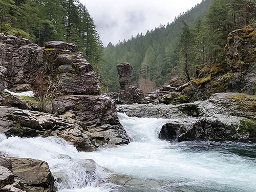
Incredible vistas await while backpacking in the Mt. Jefferson - Jefferson Park Trail Area and the Opal Creek Scenic Recreation Area.
Many day hiking opportunities can be found throughout the district such as the Detroit Reservoir Trail Area and Coffin Mountain Trail Area.
Other Recreation
Many areas offer great boating and swimming such as the Detroit Lake Area, Elk Lake Campground, and Three Pools Day Use Area.
Sweet Home Ranger District (US Highway 20) Facility
Sweet Home Ranger District (US Highway 20)
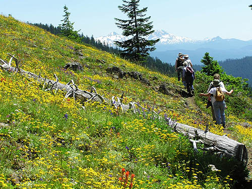 Sweet Home Ranger District is in the middle part of the Willamette National Forest. This area is accessible from the west via Highway 20 from Albany, OR, or from the east on Highway 20 from Sisters.
Let the Sweet Home Ranger District give you a taste of the sweet life! You’ll find mountain biking adventures, incredible wildflower hikes, swimming areas to keep cool on a hot summer day, and much more.
Guided Hikes
Sweet Home Nature and Heritage Tours offer incredible opportunities to learn about the plants, animals, geology and cultural history of the Sweet Home area, located on the edges of the Willamette Valley and within the spectacular Cascade Mountains.
Camping
Keep cool on a warm summer day at one of the popular campground and swimming areas such as Fernview Campground, House Rock Campground, or Trout Creek Campground.
Hiking
If you like wildflowers take a hike in the Old Cascade Crest Trail Area or the Tombstone Pass Trail Area (especially Iron Mountain Trail). The Hackleman Old Growth Trail is a short 1/4 mile hike, but offers spectacular sightings of old growth trees and views of the South Santiam River.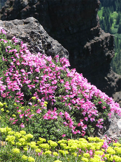
Other Recreation
Grab your bike and get your legs and heart pumping on the Santiam Wagon Road Trail Area and Iron Mountain.
Uncover the past at Longbow Organization Camp.
Middle Fork Ranger District (Hwy 58) Facility
Middle Fork Ranger District (US Highway 58)
 Middle Fork Ranger District is the southern part of the forest, bordering the Deschutes and Umpqua National Forests. Accessible from the west on Highway 58 from Eugene, OR, or from the south via Highway 58.
Spend some time exploring Waldo Lake, one of the gems of the forest, but don’t forget to get out on some of the great mountain biking, hiking, and horse trails in this area.
Hiking
Backpacking and day hikes can be found all over the district including, Fall Creek Trail Area, and Hardesty Trail Area. For spectacular mountain scenery, try a hike in the Willamette Pass Trail Area
Other Recreation
The renowned Middle Fork Willamette Trail #3609, Dead Moutain Trail and Alpine Trail are just a few of the more popular mountain biking areas.
One of the gems of the Willamette National Forest is the Waldo Lake Area provides many recreational opportunities including horse camping, non-motorized boating, swimming, hiking and biking.
For those who prefer to travel by horse, the spectacular Diamond Peak Trail Area offers multiple trails For those that enjoy travel of the motorized type, OHV enthusiasts can enjoy the Huckleberry Flats OHV Trail.
McKenzie River Ranger District (Hwy 126) Facility
Explore the McKenzie River Ranger District (Highway 126)
 McKenzie River Ranger District is in the middle part of the Willamette National Forest, bordering the Deschutes National Forest. Accessible from the west via Highway 126 from Eugene, OR, or from the east on Highway 20 from Sisters.
The McKenzie River Ranger District is a collection of stunning lakes and waterfalls, epic mountain biking and rafting, and opportunities to explore history.
Hiking
Get your water fix at the Upper McKenzie Trail Area hiking the Water Falls Loop Trail #3503 where you can see the popular Sahalie and Koosah Falls. View the headwaters of the McKenzie River at the stunning Clear Lake Loop Trail #4341.
Other Recreation
The O’Leary trail complex and Upper McKenzie Trail Area offer some of the best mountain biking on the forest. Road cyclists will love the challenge of the McKenzie Pass-Santiam Pass National Scenic Byway and the views are spectacular from your vehicle as well!
Don’t miss the Dee Wright Observatory, along the scenic McKenzie Highway (Hwy 242), for panoramic views of Cascade peaks such as Mount Washington and the Three Sisters. For Highway 242 opening and closing dates, check the Oregon Department of Transportation website.
History buffs will enjoy a stop at Fish Lake Interpretive Day Use sites, or try spending a night at an historic guard station (reservations required) such as Box Canyon Guard Station or Indian Ridge Lookout.
Take a guided trip down the river with one of our McKenzie River Permitted Outfitters and Guides.
Opal Creek Wilderness Facility
The 20,454 acre Opal Creek Wilderness features steep and rugged forested hillsides. The eastern portion of the area encompasses the headwaters of two major creeks (Battle Axe Creek and Opal Creek) which join to become the Little North Santiam River. The western portion of the area is dominated by two prominent peaks, Whetstone and Henline mountains, which offer scenic vantage points and were once used as fire lookout sites.
The area is forested with Douglas fir, Pacific silver fir and Western hemlock plant associations. Western red cedar and Pacific yew occur in wet lowlands while higher ridges have some Engelmann spruce and mountain hemlock. Common hardwoods include big leaf maple and red alder. Understory vegetation includes huckleberry, vine maple and rhododendron. Various bird species, deer, black bear, cougars and elk use the wilderness area in the summer months.
There are eight trails totaling 36 miles. These are remnants of the early day prospecting and fire access routes. Most are single destination, in-out trails with little opportunity for loop travel. Many end at old lookout sites which provide some views. Other trails traverse both the Opal Creek Wilderness and Opal Creek Scenic Recreation Area.
Because of the remoteness and steep topography, very little overnight camping occurs.
Special regulations are in place to help protect this area and preserve the experience for you and for future visitors. Please practice Leave No Trace Principles during your visit. Garbage service is not provided so please pack-it-in pack-it-out.
Opal Creek Scenic Recreation Area Facility
Travel Oregon’s “Grant’s Getaways” features the Opal Creek Wilderness
This popular destination, known for its great beauty where old growth towers above the Little North Santiam River, is enjoyed by around 20,000 visitors each year.
Legislation designating the Opal Creek Wilderness and the Opal Creek Scenic Recreation Area was passed in 1996 and established November 1998. The Opal Creek Scenic Recreation Area is 13,538 acres. It includes Elkhorn Creek, a Wild and Scenic River. The Opal Creek Wilderness is 20,827 acres and includes the 8,000 acres of the Bull of the Woods Wildernes, located within the Willamette National Forest Boundary. After the designations, an advisory council was set up to guide management of this special area.
Today, many trails traverse across Opal Creek Wilderness and the adjoining Bull of the Woods Wilderness.
The Opal Creek Ancient Forest Center, a non-profit under a special use permit with the Willamette and Mt. Hood National Forests, operates from jawbone flats, a historic mining town in the heart of the forest.
Special regulations are in place to help protect this area and preserve the experience for you and for future visitors. Please practice Leave No Trace Principles during your visit. Garbage service is not provided so please pack-it-in pack-it-out.
Elk Lake Campground Campground
List of CampsitesThis 17 site tent-only campground, located adjacent to the Bull of the Woods and Opal Creek Wildernesses, is full of beauty in the summer. Wildflowers are a beautiful sight in the campground's meadows around July. Swim or paddle in the quiet waters of the non-motorized lake, go for a great hike with views of multiple Cascade peaks, or just kick back and relax in the campground.
Three Pools Day Use Area Facility
Three Pools Day Use Area on the North Fork of the Santiam River is an extremely popular destination, attracting over 15,000 visitors each year. Accessible via a short walk from parking area (fee or recreation pass required), spectacular emerald pools and several picnic sites make this one of the most visited swimming locations in Oregon. Expect to see some large crowds here on a sunny day.
Special regulations are in place to help protect this area and preserve the experience for you and for future visitors. Please practice Leave No Trace Principles during your visit. Garbage service is not provided so please pack-it-in pack-it-out. Alcohol is prohibited and the use of marijuana on federal lands is illegal.
The trailhead can be very crowded, especially on summer weekends. Carpool if possible. Park only in designated spots. Tightly packed cars and resulting congestion can prevent emergency vehicle access. If the parking lot reaches capacity it may be unable to accommodate you.
Swimming Safety:
- Jumping from cliffs can be dangerous due to shallow water, submerged rocks, trees, or other hazards.
- Always supervise children closely. Do not read, play cards, talk on the phone, or engage in any other distracting activity while watching children in or around water.
- Rocks along the water's edge may be slippery when wet or dry.
- If you choose to cross a stream by going through it, study the area first. Avoid deep and/or swift water.
- When crossing on a natural bridge of rocks or logs, consider where you will land if you fall. Never cross above rapids or falls.
- If you fall into fast-moving water, do not try to stand up. The force of the water will push you over and hold you under. Most drownings result from getting a leg or ankle caught in an underwater rock ledge, between boulders or snagged in tree limbs or other debris. Lay on your back with your feet pointing downstream and toes pointing up toward the surface. Always look downstream and be prepared to fend off rocks with your feet.
Upper Arm Day Use Area Facility
Upper Arm is situated on a quiet cove of the Breitenbush Arm of Detroit Lake away from motor boating activities. Fishing opportunities abound along the shoreline trails and from the wooden fishing pier. Enjoy calm water at the sandy swimming beach. Observe various species of waterfowl and birds from the wildlife viewpoint.
Detroit Lake Facility
In the summer months, this 3,500-acre, 9-mile long lake in the Cascades below Mt. Jefferson is a popular recreation area for fishing, boating, water skiing, swimming, camping, and picnicking. The U.S. Forest Service and Oregon Department of Parks and Recreation and operate numerous boat ramps, campgrounds and day-use areas around the lake. Two privately owned marinas are located near the town of Detroit.
Both Detroit and Big Cliff lakes are located 43 miles southeast of Salem on the North Fork of the Santiam River. They are operated by the Corps of Engineers as part of a system of thirteen multi-purpose dams and reservoirs that make up the Willamette Valley Project. These dams and reservoirs work together for the purposes of flood damage reduction, hydropower generation, irrigation, recreation, fish and wildlife enhancement, and downstream water quality improvement within the Willamette River drainage system.. To learn more about the lake and construction of the dam visit the Army Corps of Engineers website at http://www.nwp.usace.army.mil/
In late summer, early fall through spring, the water levels on Detroit and Big Cliff lakes are frequently drawn down to the point where boat launches are no longer available. Reservoir and river level information is available from the US Army Corps of Engineers here. Watch for obstructions near the shoreline such as submerged stumps, logs and rocks. Small craft should stay out of open waters when it is windy since dangerous waves can build up suddenly.
Fish Your National Forests: This site can be accessed by Passenger Car; Fish available include: Trout, Native Trout; Types of fishing available include: Shore, Motorized boat, Float tube, Fly, Spin, Bait; ADA Accessible fishing access with fishing pier, boat launch, and fish cleaning station
View more Popular Lakes & Rivers
Middle Santiam Wilderness Facility
Ranges from steep slopes, high peaks, and ridges at the higher elevations to gently sloping and benchy terrain in the lower elevations. The most prominent features are Chimney Peak, Donaca Lake and the Middle Santiam River. Native fish populations thrive in both river and lake.
Much of this wilderness is forested with mature stands of old-growth Douglas-fir, western redcedar and western hemlock at lower elevations and true firs near ridgelines.
Menagerie Wilderness Facility
This area focuses around a series of rock pinnacles each uniquely named from the imagination of past climbers; hence the name, Menagerie. The best known, and most popular is Rooster Rock. Mountaineers from around the Pacific Northwest use the spires and cliffs to hone their technical climbing skills. This is primarily a low elevation wilderness and can be used year-round.
A thick forest of second growth Douglas-fir, western hemlock, western red cedar dominate the area.
Know Before You Go
- ''Leave No Trace'' techniques are encouraged in Wilderness areas, including properly disposing of human and pet waste and carrying out all trash; click here for more information.
- There are no facilities within the Menagerie Wilderness.
Alder Springs Campground Campground
List of CampsitesThis small, rustic site is right on the side of the historic McKenzie Pass Highway. Surrounded by towering Douglas fir trees, this is a perfect spot to be on a warm day.
Access to Linton Lake Trailhead in the Three Sisters Wilderness is immediately across the highway from the campground.
Cougar Crossing Campground Campground
List of CampsitesLocated on the confluence of the South Fork of the McKenzie River and the south end of Cougar Reservoir, Cougar Crossing is open year round and offers 11 sites that can accommodate either RV or tent camping. Vault toilets are provided. There is firewood for sale. The interior roads and spurs are gravel. There is no drinking water. It is the closest campground to Terwilliger Hot Springs.
McKenzie Bridge Day Use Area Facility
This Day Use Area offers a chance to relax under towering Douglas-fir and western red cedar trees while listening to the rushing water of the McKenzie River.
The site provides river access and includes a boat ramp. It is adjacent to the McKenzie Bridge Campground.
Terwilliger (Cougar) Hot Springs Facility
 As you walk the 1/4 mile trail to this clothing optional hot springs, you are enveloped in the dark hues of primeval woodland, touched by mottled light filtering down from treetops high above and the invigorating scene of the lagoon with the gorgeous Rider Creek waterfall spilling into it.
There are six soaking pools spaced apart by rock walls laid out in steps down a ravine. Temperatures range from 85 degrees in the lower pool to 112 degrees in the upper pool. The pools are 3-12 feet across and an average of 2-3 feet deep. The pool floors are mostly bedrock but some gravel, sand and debris remain at the bottom of the pool.
If you do visit this popular hot springs, please preserve the experience for you and for future visitors by observing the following: There is no alcohol allowed, the hot springs are for day use only and camping is restricted to developed campgrounds in the Cougar Recreation Area.
Smith Reservoir Area Facility
Stocked annually with trout, Smith Reservoir makes a good fishing spot. Boats can be launched from a site near the dam (a 10 mile per hour speed limit for boats is enforced). Lakes End Campground is the one campground located on the reservoir and is accessible only by boat. Beautiful Sahalie and Koosah Falls are nearby on the McKenzie River National Recreation Trail.
The reservoir when full, spans 170 acres. In late summer, early fall through mid-March, the water levels on Smith Reservoir are frequently drawn down to the point where the boat launch is no longer available. Reservoir and river level information is available from the US Army Corps of Engineers here. Watch for obstructions near the shoreline such as submerged stumps, logs and rocks. Small craft should stay out of open waters when it is windy since dangerous waves can build up suddenly.
View more Popular Lakes and Rivers
Waldo Lake Wilderness Facility
The High Cascades portion is characterized by steep to moderate slopes and includes many basin areas with lakes, meadows, and rock outcrops. The Western Cascades portion is typified by steep, dissected slopes.
There is an impressive array of lakes scattered throughout the Wilderness which includes the Six Lakes Basin, Eddeeleo Lakes, and Quinn Lakes. Located just outside the eastern boundary of the wilderness is Waldo Lake, one of the purest in the world. This lake, scooped out by ancient glaciers, covers 10 square miles and reaches a maximum depth of 420 feet. On a clear day, you can see to depths of 100 feet.
Waldo Lake Wilderness area covers 36,572 total acres. There are approximately 84 miles of trails which lead to many lakes and small meadows. Waldo Lake Trail (not in wilderness) provides users with a 22-mile loop around Waldo Lake. The High Cascades are mostly Douglas-fir, mountain hemlock, and Pacific silver fir. This Wilderness is approximately 98% forested.
Diamond Peak Wilderness: Willamette Facility
Diamond Peak Wilderness straddles the Cascade Mountains. Diamond Peak was formed as the entire land mass of the Cascades was undergoing volcanic activity and uplift. Great glaciers carved the large volcanic peak and when they receded, the bulk of the mountain remained, with snowfields near the summit and dozens of small lakes surrounding the peak.
Diamond Peak Wilderness area covers 52,611 total acres. Lakes from one to 28 acres in size dot the landscape. Approximately 14 miles of the Pacific Crest National Scenic Trail pass through this wilderness. Another 38 miles of trail, including the 10-mile Diamond Peak Trail, stretches the length of the west side of the peak.
Nearly the entire area is covered with mixed stands of mountain hemlock, lodgepole and western white pine, and silver, noble and other true firs.
Know Before You Go
- Wilderness Permits are required when visiting the Diamond Peak Wilderness between the Friday of Memorial Day weekend and October 31.
- Learn about Wilderness Regulations, including special area regulations in the Diamond Peak Wilderness.
- "Leave No Trace" techniques are encouraged in Wilderness areas, including properly disposing of human and pet waste and carrying out all trash; click here for more information.
- There are no facilities within the Diamond Peak Wilderness.
- Find out about the Weed Free Feed Requirement and other good Know Before You Go tips.
Blue Pool Campground (Middle Fork Ranger District) Campground
List of CampsitesThis 24-site campground is conveniently located adjacent to Oregon State Highway 58 in an old growth forest alongside Salt Creek.
Fishing and swimming are popular activities. A large picnic area along the creek offers picnic tables, a large grassy area for both passive and active recreation. One-half mile east of the campground on Highway 58 is the McCredie Day Use Area & Hot Springs. The site was formally developed as a hot springs resort historically; currently the hot springs area is unimproved. Caution should be exercised when using the hot springs, water temperature is very high in the pools.
Indigo Springs Campground Campground
List of CampsitesThis small, three site tent-only campground is surrounded by a fine stand of old growth Douglas-fir.
The springs for which the camp was named originates nearby along an easy, 500' round trip loop trail. Additionally, interpretive signs explain the role of the historic Oregon Central Military Wagon Road (a portion passes near the campground) and the role of the Bull trout in the regional watershed ecosystem. Equestrians, hikers,and off-road cyclists can easily access the Middle Fork Trail across Forest Road 21.
C.T. Beach Picnic Area and Boat Launch Facility
Located on the Hills Creek Arm of Hills Creek Reservoir, this day use only site offers two picnic tables and one fire ring. If fires are allowed, use caution during summer, as upslope winds can be strong off the reservoir.
Note there is no designated swimming area at C.T. Beach and no warning buoys for boaters.
Little Cowhorn Mountain Lookout Facility
Elevation: 4243 ft.
Built: 1960, Flat-roof w/cab
Trail: 1 mile, moderate
Staffing: not currently staffed by Middle Fork R.D.
Little Cowhorn is a must-visit lookout point in the Forest. It has a long history of maintenance by volunteers and is in very good condition. The mountaintop is a very open, rocky area that can be safely explored and traversed. The views of the Cascade Crest are somewhat distant, but you will have excellent vistas of the western edge of the Forest, and some major watersheds, such as Fall Creek. The trail rises through several types of vegetation and terrain, including deep timber, rocky outcroppings with dramatic towering faces, exposed flowering rocky slopes, and the grassy mountaintop area. An excellent early season warm-up hike or close-in late-season outing. Exercise caution on the final approach, which traverses a rock face, with handrail.
Huckleberry Mountain Lookout Facility
Elevation: 5545 ft.
Built: 1938, hip-roof
Trail: 1/2 mile ; easy.
Staffing: currently seasonal staffed by Middle Fork Ranger District
Huckleberry is a charming and gentle site marked by sweeping views from the tip of Mt. Hood to the north to Mt. Scott and Thielsen to the south. The Sisters are close and sharp, Diamond Peak equally so. The view to the east is primarily of the western slope wilderness areas. To the west lie High Prairie, Salmon Creek, and the hills surrounding Oakridge. The building is in excellent condition as a result of a 3-year painstaking historic rehabilitation.
Huckleberry's open, grassy vistas present several opportunities for exploring, including to the south beyond a rocky promontory used by the Kalapuya Indians, and to the north on the one remaining fragment of the original trail through a clearcut and a heavy stand of huckleberries, old timber and rhododendron. And don't forget the trail down into the Huckleberry Lake basin. The area is rich in history, scenic delights, and is an altogether wonderful site.
Winter Recreation Area: Santiam Pass (Hwy 20) Facility
At the crest of the Cascade Mountains, winter snows and spectacular views of volcanoes, including Three Fingered Jack to the north and Mount Washington to the south, make Santiam Pass an ideal area for the whole family to enjoy a range of winter sports.
Skiing/Snowboarding
From the east, Highway 20/126 takes you to top of the pass, where you’ll find Hoodoo Ski Area, a full service lodge with chairlifts that provide access to a variety of skiable terrain.

Sno-Parks: cross-country skiing, snowshoeing, snowmobiling, sledding
Some of the more popular sno-parks on the pass are Ray Benson (cross-county skiing, snowmobiling, dog sledding), and Santiam Pass (cross-country skiing, sledding, snow play).
Heading west you’ll find Maxwell Butte (cross country skiing).
Highway 20 brings you to Lava Lake Sno-park and Tombstone Sno-park and Highway 126 leads you to Little Nash Sno-park and Ikenick Sno-park.
For the snowmobiling enthusiast, head north on Highway 22 to the McCoy Snowmobile Area.
More Information
A detailed map of the area is available for purchase from any of our offices or from our Maps & Publications section.
Contact or visit one of our ranger stations to find maps, guidebooks and staff available to supply information on recreation, road conditions and more.
Salt Creek Sno-Park Facility
 |  |  |
Salt Creek Sno-Park offers cross-county and snowshoe trails and a family-friendly snow play area. Crossing the highway to the Fuji Creek Road (FS Rd 5894) leads the fit and prepared skier uphill 3 miles into the challenging Island and Birthday Lakes ski trail system and the Fuji Shelter, a three-sided structure with a wood stove, and a loft for overnight camping. You can also snowshoe or ski the Salt Creek Falls trail for a icy view of Oregon’s second highest waterfall.
Know Before You Go in Winter: Tips on how to plan ahead and prepare for your trip to ensure the best possible time for you and others who will be sharing the snow with you.
Waldo Lake Sno-Park Facility
This site is fairly popular with snowmobile enthusiasts, but parking is limited. Skiers may want to use the Gold Lake Sno-park instead and access Waldo Lake Road by skiing up Gold Lake Road to Gold Lake Trail. Two miles up Gold Lake Trail, Fuji Mountain Trail leads west to Waldo Lake Road. Waldo Lake Road is a shared snowmobile/ski route, but snowmobiles are not permitted on other nordic trails in this area. A fit and well-prepared skier may choose to travel approximately 8 miles out the road to the Betty Lake Trail, the Twins and the South Waldo Shelter (three-sided with a wood stove and wooden bed.)
Know Before You Go in Winter: Tips on how to plan ahead and prepare for your trip to ensure the best possible time for you and others who will be sharing the snow with you.
Map of Willamette Pass Winter Trails
Winter Recreation Area: Willamette Pass (Hwy 58) Facility
When you’re tired of the rain, grab your thermos, cross-country skis, snowshoes or sleds and head up into the hills! Winter recreation opportunities in the Willamette Pass area include a system of backcountry trails and winter shelters.
Skiing/Snowboarding
Willamette Pass Ski Area is located 66 miles from Eugene, Oregon and offers a wide variety of activities the whole family will enjoy including downhill skiing, snowboarding, and Nordic trails.

Sno-Parks: cross-country skiing, snowshoeing, snowmobiling
You can snowshoe, cross-country ski, and snowmobile from several sno-park locations in this winter recreation area. Popular sno-parks include Waldo Lake Road (cross country skiing and snowmobiling), Salt Creek Falls (cross country skiing), and Gold Lake Road (cross country skiing).
More Information
A detailed map of the area is available for purchase from any of our offices or from our Maps & Publications section.
If you're looking for more information contact or visit one of our ranger stations to find maps, guidebooks and staff available to supply information of area recreation, road conditions and more.
South Waldo Shelter Facility
| Gold Lake Sno-Park » South Waldo Shelter |
For those with an overnight destination in mind who are looking for a route with some distance, consider the trail leading to South Waldo Shelter, a trail recommended for the equipped and experienced skier.
From Gold Lake Sno-Park, follow Gold Lake Road to its end just across the bridge over the outlet of Gold Lake. From there, follow Gold Lake Trail to the marked intersection with Mount Ray Trail.
When you reach Waldo Lake Road, follow it (or continue on Gold Lake Trail) north to a marked trailhead. From here, a marked trail drops down to Betty Lake, passes several small lakes, and makes a sharp turn to the southwest.
It then continues to a shelter on the edge of a meadow. Distance from Waldo Lake Road to South Waldo Shelter is about 3.9 miles.
Note: Waldo Road is also a marked snowmobile route.
Fuji Creek Road/ Fuji Shelter Facility
| Salt Creek Sno-Park » Fuji Creek Road/ Fuji Shelter |
This route is geared for the skier who is willing to spend time climbing uphill to gain significant altitude for an easy slide back to the car. From Salt Creek Sno-Park, walk the access road back to Highway 58. Use extreme caution when crossing the highway to gain access to Fuji Creek Road.
From there, begin a moderate/steep climb of 1,500 feet over four miles. There are several openings along the way, which offer excellent views of Diamond Peak and the Salt Creek canyon. Fuji Shelter, perched at 5,600 feet, is located off the road on the left. Look for the sign marking your turnoff. The shelter has a wood stove, sleeping loft and a superb view of Diamond Peak.
For the more accomplished skier, an alternative route is to ski up Fuji Mountain Trail from the Waldo Lake Road and take the Fuji Shelter Tie to the shelter.
Opal Creek Trailhead (Gate) Facility
This trailhead provides access for:
These trails provide access to Opal Creek Scenic Recreation Area and Opal Creek Wilderness.
Riggs Lake Trailhead Facility
This is the trailhead for Riggs Lake Trail #3388
See trail page for more information.
Browder Ridge Trailhead Facility
This is the trailhead for:
See trail page for more information
Gander Lake Trailhead Facility
This is the trailhead for Gander Lake Trail.
Blair Lake Trailhead Facility
This trailhead provides access to Blair Lake Trail.
North Fork Trail Trailhead (Segment 1) Facility
This trailhead provides access for North Fork Trail (Segment 1).
Clark Creek Nature Trailhead Facility
This trailhead provides access for
Fuji Mountain Trailhead at Road 5883 Facility
This trailhead provides access for Fuji Mountain Trail.
McKenzie River Trailhead - Upper Facility
This trailhead provides access to McKenzie River National Recreation Trail #3507, Santiam Wagon Road #3413, and Clear Lake Loop Trail #4341.
McKenzie River Trailhead at Paradise Campground Campground
List of CampsitesThis trailhead provides access to McKenzie River National Recreation Trail #3507.
Box Canyon Trailhead Facility
This trailhead provides access to:
See Trail page for more information.
Frissell South Trailhead Facility
This trailhead provides access to:
See Trail page for more information.
Terwilliger (Cougar) Hot Springs Trailhead Facility
This trailhead provides access to:
See trail pages for more information.
Roaring Ridge South Trailhead Facility
This trailhead provides access to:
See Trail page for more information.
Marilyn Lakes Trailhead Facility
This trailhead provides access to:
See Trail page for more information.
Deception Butte Trailhead - Lower Facility
This trailhead provides access to Deception Trail #3466
See Trail page for more information.
Eugene to Crest Trailhead #1 Facility
This trailhead provides access to Eugene to Crest Trail #3559
There are over seventeen access points to this trail. They are best described in a brochure available at the Middle Fork Ranger District or by clicking here. At least ten of the access points utilize existing trailheads.
Alpine Trailhead #3 Facility
This trailhead provides access to:
See Trail page for more information.
Eugene to Crest Trailhead #2 Facility
This trailhead provides access to Eugene to Crest Trail #3559
There are over seventeen access points to this trail. They are best described in a brochure available at the Middle Fork Ranger District or by clicking here. At least ten of the access points utilize existing trailheads.
Bunchgrass Trailhead - Upper Facility
This trailhead provides access to the Eugene to Crest Trail #3559
Formerly labeled Trail #1575, the Bunchgrass Ridge Trail is now part of the Eugene to Crest Trail #3559. This 25 mile ridgeline trail connects Oakridge to Waldo Lake, but a smaller section can be done between the Bunchgrass Ridge upper and lower trailheads. This segment is a high elevation ridgeline trail that follows the edge of the 1991 Warner Creek burn with views of bunchgrass meadows, Cascade peaks, and wildflowers.
Fuji Mountain Trailhead at Gold Lake Facility
This trailhead provides access to:
See Trail page for more information.
Eugene to Crest Trailhead #4 Facility
This trailhead provides access to Eugene to Crest Trail #3559
There are over seventeen access points to this trail. They are best described in a brochure available at the Middle Fork Ranger District or by clicking here. At least ten of the access points utilize existing trailheads.
Eugene to Crest Trailhead #3 Facility
This trailhead provides access to Eugene to Crest Trail #3559
There are over seventeen access points to this trail. They are best described in a brochure available at the Middle Fork Ranger District or by clicking here. At least ten of the access points utilize existing trailheads.
WHISPERING FALLS CAMPGROUND Campground
List of CampsitesOverview
Whispering Falls Campground is an excellent outdoor retreat designed for campers more interested in a remote experience. Guests are greeted with grand, mature cedars and Douglas fir trees as they drive into the campground.The Coffin Mountain Trail Area is located nearby, with splendid trails to explore like the Coffin Lookout and Bugaboo Ridge Trails.
Recreation
Anglers enjoy fishing for rainbow trout on the river. Among the many options for hiking and biking trails, the Mt. Jefferson-Pamelia Lake Trail Area is bound to please all types. Hikers looking for a challenging trail will enjoy the Minto Mountain Trail.Facilities
This campground has 16 sites, 10 of which are reservable. Sites have picnic tables, grills and easy access to the vault toilets. Drinking water spigots are spread throughout the campground. Most campsites offer views of the river.Natural Features
Whispering Falls is located along the North Santiam River at an elevation of 2,000 feet. Surrounding vegetation includes hemlock, rhododendron and fern, among the towering conifers.The campground is in the North Santiam Travel Corridor of the Willamette National Forest. The forest covers 1.6 million acres on the western slopes of the Cascade Range.
Nearby Attractions
Detroit Lake provides plenty of opportunity for water recreation like boating, water skiing and kayaking. The Marion Forks Fish Hatchery down the highway, along Marion and Horn Creeks, is an interesting place to visit. Here, visitors can see rainbow trout, summer steelhead and spring chinook being harvested.Battle Ax Creek Trailhead Facility
This trailhead provides access to:
See Trail page for more information.
YUKWAH CAMPGROUND Campground
List of CampsitesOverview
Yukwah Campground is a nice, family campground situated along the South Santiam River, 21 miles east of the town of Sweet Home, Oregon. Many sites are right on the river, tucked under the cool shade of Douglas fir and Hemlock trees.
The campground was built by the Civilian Conservation Corps (CCC) in the 1930s. Plenty of river activities and hiking opportunities await.
Recreation
Wading and fishing are popular in the river and campers can stroll the half-mile long an accessible trail that winds along the banks of the South Santiam River within the campground and accesses a viewing pier over the river.The Menagerie Wilderness can be accessed from the Trout Creek Trail (1/4 mile from campground) where hikers can reach the top of Rooster Rock and enjoy views of the river valley (5.6 miles round trip). An accessible hike leaves from the same trailhead and takes visitors to the Walton Ranch Platform with views of the Walton Meadow (1/8 mile round trip).
Facilities
This is a smaller campground with a variety of sites to accommodate different uses, with group sites, sites for trailers and sites for tents. Drinking water is from two hand pump wells. Parking spurs are gravel and roads are paved. Vault toilets and garbage cans are spread out in convenient locations in the campground. It is recommended that you bring your own firewood. You can purchase firewood, at Riverbend County Park, 45931 Santiam Hwy., Foster, OR 97345.
Natural Features
Yukwah Campground is tucked in a heavily wooded landscape with lichen and moss-draped alder, Douglas fir and Maple trees. Campsites are well-shaded and full of ferns and similar sub-tropical greenery. Many sites stretch along the South Santiam River and have river access.
Nearby Attractions
Hike or bike the Santiam Wagon Road (now a trail), a historic trail used to transport livestock east across the Cascade Mountains to central Oregon's grasslands. Iron Mountain, Gordon Meadows and Echo Basin are nearby hiking areas well known for their colorful wildflowers.
SANTIAM FLATS CAMPGROUND Campground
List of CampsitesOverview
Santiam Flats Campground rests on the shores of the sparkling Detroit Lake. Visitors enjoy fishing, boating on the lake, and hiking on the nearby Stahlman Point Trail.Recreation
Sailing, boating, water skiing and fishing are all excellent options for enjoying Detroit Lake. Catfish, rainbow trout and Kokanee salmon are among the most common species found in the lake.Several hiking trails dot the area, including Stahlman Point Trail, which offers beautiful vistas of Detroit Lake and the surrounding area. The Hoover Nature Trail is an accessible, short footpath that delights many campers.
The Willamette National Forest has about 1,700 miles of trail. While many are in wilderness areas, a number of trails are low-elevation, easy-access trails for year-round hiking.
Facilities
Sites have picnic tables, grills and easy access to the vault toilets. Drinking water spigots are spread throughout the campground. Most campsites offer views of the lake. Santiam Flats does not have a boat launch ramp. Some of the sites are adjacent to the shoreline and mooring is allowed.Natural Features
The campground lies in the Willamette National Forest, which stretches for 110 miles along the western slopes of the Cascade Range. The varied landscape of high mountains, narrow canyons, cascading streams and wooded slopes offer varied recreational opportunities for visitors.Nearby Attractions
Detroit Lake provides plenty of opportunity for water recreation like boating, water skiing and kayaking.HUMBUG CAMPGROUND Campground
List of CampsitesOverview
Humbug Campground is surrounded by old-growth forest, and during the months of May through July, the rhododendrons bloom in a spectacular show of pink blossoms. Recreation in the area is abundant -- plan on a quiet stroll through this lush forest or fishing on nearby Breitenbush River.Recreation
Wading and fishing are popular activities in the Breitenbush River, and rainbow trout is the most common catch for anglers.The Willamette National Forest has about 1,700 miles of trail. While many are in wilderness areas, a number of trails are low-elevation, easy-access trails for year-round hiking.
Facilities
Humbug Campground sites have picnic tables, grills and easy access to the vault toilets. Drinking water spigots are spread throughout the campground. Most campsites offer sweeping views of the river.Natural Features
The campground lies in the Willamette National Forest, which stretches for 110 miles along the western slopes of the Cascade Range. The varied landscape of high mountains, narrow canyons, cascading streams and wooded slopes offer varied recreational opportunities for visitors.The Breitenbush River is a tributary of the North Santiam River, and its clean waters flow from short forks of snowmelt in the Mount Jefferson Wilderness.
A variety of plants and foliage separate the spacious campsites and provide privacy from other sites.
Nearby Attractions
Detroit Lake has a marina and provides plenty of opportunity for water recreation like boating, water skiing and kayaking.ISLET CAMPGROUND Campground
List of CampsitesOverview
Waldo Lake is one of the largest natural lakes in Oregon. It offers a uniquely peaceful setting on the water and along remote shorelines, surrounded by forests of Douglas fir and mountain hemlock. Recreation in the area is abundant with the lake an ideal location for water activities like sailing, canoeing and swimming.Recreation
Waldo Lake is circled by the Jim Weaver Loop, 22 miles of trail for hiking and biking. Bikes are allowed on the trails, but not in the nearby Waldo Lake Wilderness. There is also easy access to the Pacific Crest Trail.Facilities
This 55 site campground is located at the north end of Waldo Lake, just south of North Waldo Campground, 31 sites are reservable. Each site has a fire ring and picnic table. There are three vault restrooms within the campground and another at the boat launch/day use area. Islet offers wonderful sandy beaches. Western winds consistently blow each afternoon, offering respite from early season mosquitoes, which are typically intense from June to mid-August so come prepared.Natural Features
Situated high on the western slopes of the Oregon Cascades at 5,400 feet in elevation, Waldo Lake is one of the purest lakes in Oregon (9.8 square miles with a maximum depth of 427 feet). It has no permanent inlet to bring nutrients into the lake for plant growth. The lack of plant life contributes to its purity, allowing you to see to depths of 120 feet on a calm day.Nearby Attractions
The north end of Waldo Lake is a popular starting point for many wilderness trails and lakes, most notably the Rigdon, Wahanna and Torrey Lakes. The 1-mile Shoreline Trail between Islet and North Waldo campgrounds provides a short and pleasant hike along the lakeshore.SOUTHSHORE AT DETROIT LAKE Campground
List of CampsitesOverview
At an elevation of 1,604 ft., Southshore Campground is located on the south shore of Detroit Lake, a little west and south of Piety Knob Island. Campsites are surrounded by towering trees, creating a secluded atmosphere. Visitors enjoy exploring the area and discovering osprey hovering above or nesting in the trees. The campground lies in the Willamette National Forest, which stretches along the Cascade Range.Recreation
Detroit Lake is a popular destination for boating, jet skiing, swimming and fishing. Rainbow trout, Kokanee salmon and catfish are found in the lake. A boat ramp and dock are located next to the campground.Facilities
The campground offers 25 single and five double family campsites. There are vault toilets and drinking water onsite. Coin operated showers are available a mile away at Cove Creek.In the day use area, there is about 1,000 ft. of shoreline. There is a dock for launching, loading and unloading only. There is no mooring allowed.
Natural Features
A mix of wooded and open sites are available, located a little further away from the busier portions of Detroit Lake. You'll find quiet camping on all but the busiest weekends. Detroit Lake covers 3,500 acres and is surrounded by groves of Douglas fir.Nearby Attractions
Additional hiking trails can be found across the lake, including those that lead to Dome Rock and Needle Rock. The town of Detroit is across the lake with hometown activities. The Cascading Rivers Bikeway is available for cyclists of all ages.Jefferson Park Area - Mt. Jefferson Wilderness Facility
The Jefferson Park area within the Mt. Jefferson Wilderness is an incredibly popular destination, providing iconic views of Mt. Jefferson, alpine lakes and abundant wildflowers. Backpacking, day hiking and mountaineering are the most common forms of recreation in the area during the short summer season. Opportunities for nature photography also abound.
Mt. Jefferson and Park Ridge are the dominant features of the Jefferson Park area. Mt. Jefferson's slopes are mantled by five glaciers: Whitewater, Waldo, Milk Creek, Russell and Jefferson Park. Jefferson Park proper consists of sensitive subalpine meadows and lakes with an extremely short growing season. Vegetation is dwarfed with old-growth mountain hemlock the size of most 10-20 year old conifers. Other geographic features include steep talus slopes, rock outcrops and alpine meadows.
To assist in planning an overnight trip into the Jefferson Park area, take time to review the Jefferson Park vicinity map, map of Bays, Scout, Rock and Park Lakes , which includes 26 designated campsites or view the Russell Lake map for four additional designated campsites. If camping within 250 feet of any of the lakes in Jefferson Park you must camp within a designated site.
The sensitive meadows and fragile vegetation of Jefferson Park’s subalpine ecosystem take decades of recovery once damaged. With the popularity of Jefferson Park, please help protect this area and preserve the experience for you and for future visitors. ''Leave No Trace'' techniques are encouraged, including properly disposing of human and pet waste and carrying out all trash. When making a campsite selection, never camp on vegetation - select a pre-existing hardened campsite. The best campsites are found not made. Click here for more Leave No Trace information.
Visitors should obtain a detailed map of the area before planning a trip, and inquire in advance about trail conditions, particularly early in the season. Jefferson Park can hold substantial snow well into June/July on an average snow year, so plan your trip accordingly.
Know Before You Go
- Maximum group size is 12 people and 12 head of stock.
- Campfires are not permitted within the boundaries of Jefferson Park.
- Click here to read special regulations unique to the Mt. Jefferson Wilderness Area.
- Stock users must use weed-free feed; click here for more information.
- There are no facilities within the Jefferson Park area or the Wilderness area.
South Pyramid Horse Camp Facility
This horse camp was designed, installed and is maintained with the help of Mid-Valley Oregon Equestrian Trail Group. In 2013 the old corral system was replaced with a 12 horse permanent hi-line system with the help of great group of volunteers.
This horse camp offers a centrally located base camp for accessing the Old Cascade Crest and Middle Santiam Wilderness Trail Systems.
Old Cascade Crest Trails include:
- South Pyramid Creek Trail #3403
- Chimney Peak Trail #3382
- Gordan Peak Trail #3387
- Scar Mountain Trail #3402
- North Pyramid Trail #4161
- Pyramids Trail #3380
- Crescent Mountain Trail #3384
a short road ride off of the North Pyramid - Scar Mountain Trail off of Forest Service Road 2266 offers access to:
- Parish Lake Trail #3383
- Riggs Lake Trail #3388
- Daly Lake Trail #3385
Middle Santiam Trails include:
- Chimney Peak Trail #3382
- McQuade Creek Trail #3397
- Swamp Peak Trail #3401
- Gordan Peak Trail #3387
Clackamas-Breitenbush Scenic Byway (Forest Rd 46) Facility
The byway crosses through the northern part of the Willamette National Forest and into the Mt. Hood National Forest. It is part of the 220 mile West Cascades Scenic Byway, which runs north to south, skirting the northern half of Oregon's Cascade Mountain Range.
From Detroit, Oregon Forest Road 46 follows the Breitenbush River into some of western Oregon's most pristine public lands. You can stop for a refreshing soak at a natural hot springs resort, or stretch your legs on the 2.5 mile South Breitenbush National Recreational Trail. A short side trip from the main trail leads to an impressive gorge, where the Breitenbush River passes through narrow basalt. A seven-mile detour brings you to the Olallie Lakes Scenic Area and the Mount Jefferson Wilderness Area. Here, countless lakes can be accessed from developed trails; a small seasonal resort provides services. At Ripplebrook, the Byway joins Oregon Route 224 and parallels the "Wild and Scenic" Clackamas River to Estacada.
This route is also the Cascading Rivers Oregon Scenic Bikeway and is popular with cyclists. Oregon Scenic Bikeways are official state-designated routes selected and curated by experts, with printable maps, GPS and signage. Download the Oregon Scenic Bikeways guide here.
Oregon Scenic Byways Official Driving Guide
Over the Rivers & Through the Woods Scenic Byway Facility
Part of the byway travels through the Willamette National Forest’s Sweet Home Ranger District and much of the byway parallels the Santiam Wagon Road.
- Length: 66 miles
From the Oregon Department of Transportation:
This route begins in the rich farmland of the Willamette Valley then winds along rushing streams and through thick forests as it climbs into the Cascades to join the West Cascades and McKenzie Pass-Santiam Scenic Byways. Along the way you'll pass through some of Oregon's oldest settlements, while experiencing the geographic diversity of five Western Oregon ecosystems. With access to rivers, reservoirs, parks and campgrounds, many trails and snow-play areas, this Byway offers a wide range of recreational activities.
Details at https://www.tripcheck.com/Pages/Scenic-Byways-Over-Rivers-Through-Woods
Oregon Scenic Byways Official Driving Guide
Quartzville Road Back Country Byway Facility
The Quartzville Road Back Country Byway travels through a portion of the Sweet Home Ranger District on the Willamette National Forest
- Length: 50 miles
- Time to Allow: 1-2 hours to drive the byway.
From the Bureau of Land Management
Meander beside the blue-green depths of the Green Peter Reservoir and the Quartzville Creek National Wild and Scenic River as you discover a pathway of old-growth forests, highlighted with a varied collection of wildflowers and startling reds and golds of autumn foliage. Paralleling the winding river of Quartzville Creek, the Quartzville Creek Back Country Byway provides glimpses of old growth forest, wildlife and opportunities to pan for gold, fish or kayak in the waters of the creek. Camp out against the protection of a rocky outcropping, filch a few sweet summer berries from the huckleberry patches that dot the roadway, or make a bundle of sweet smelling wildflowers to remind your of your trip along this scenic road.
Learn more at https://www.blm.gov/visit/quartzville-back-country-byway.
McKenzie River Scenic Byway Facility
This byway travels through a portion of the Willamette National Forest on State Highway 126 east of Eugene, It travels along the McKenzie River and connects to the existing West Cascades Scenic Byway.
The landscape of this area was defined over the ages by actions of the McKenzie River, which created a travel route along its banks that has been in use for over 8000 years. First by the Molalla and Kalapuya tribes; in the 1800s by the European hunters and explorers and then by immigrants on wagon trains staking claims along the river. The route travels through the lower 34 miles of the 80-mile McKenzie River. It connects the I-5 corridor to two Nationally Designated Scenic Byways (McKenzie Pass-Santiam Pass and the West Cascades).
The scenic views provide an enjoyable transition from the broad agricultural plain of the lower McKenzie Valley – then heading up the narrower river canyon scenery between Vida and Blue River – before transitioning again to the more rural and wild forested lands of the upper Valley. Travelers along the McKenzie River Scenic Byway will not only experience the iconic charm of one of the Pacific Northwest’s most beautiful landscapes but also have many opportunities to learn how the area’s unique geology and hydrology support a rich habitat of flora, fauna, and fish.
Oregon Scenic Byways Official Driving Guide
The West Cascade Scenic Byway Facility
The byway travels through much of the Willamette National Forest, offering some of the best up-close views of thundering waterfalls, ancient forests, rushing whitewater, and cool, placid lakes.
- Length: 222 miles / 354.1 km
- Time to Allow: Eight hours
From the Oregon Department of Transportation
The 220 mile West Cascades Scenic Byway runs north to south, skirting the northern half of Oregon's Cascade Mountain Range. Nurtured by abundant rainfall, the Western Cascades are bursting with life. The lush forests provide excellent habitat for northern spotted owl, bald eagle, pine marten, pileated woodpecker, Roosevelt elk, blacktailed deer, and mule deer. The rivers along the byway - including the North Fork of the Middle Fork Willamette, the McKenzie, the North Santiam, and the Clackamas - support many game fish, including rainbow trout, steelhead, chinook salmon, bull trout, and a rare species of cutthroat trout. Spectacular views of snowcapped mountains (Jefferson, Washington, Three Fingered Jack, and the Three Sisters) are omnipresent - keep your camera handy! Myriad recreational activities make this byway an outdoors person's paradise. For hikers, there are three well-maintained National Recreation Trails - and hundreds of miles of other trails, all accessible from the byway. The byway's lakes provide ample opportunities for boating and swimming. Kayakers and rafters will find challenge on the whitewater portions of the rivers. Anglers will encounter willing trout in the riffles and pools that are but a short walk from the road; several fishing piers are also available on the lakes. There are faster ways to get from Eugene to Portland. But you'll be hard-pressed to find a more scenic route.
Pure, cascading rivers. Towering old growth Douglas firs. Peaceful lakes. Snowcapped volcanic peaks. This is the Oregon many visitors imagine. And this is the Oregon you'll find on the West Cascades Scenic Byway.
Details at https://www.tripcheck.com/Pages/Scenic-Byways-West-Cascades
Oregon Scenic Byways Official Driving Guide
McKenzie Pass—Santiam Pass Scenic Byway Facility
A portion of the byway travels through the McKenzie River Ranger District of the Willamette National Forest where you'll experience dramatic views of the snowcapped High Cascade Peaks. The panorama of lava fields and six Cascade peaks is made more striking by the contrast between the black lava and white snow. The mountains are mirrored in crystal-clear lakes, and the byway passes beautiful waterfalls, including Sahalie and Koosah Falls.
- Length: 82 miles / 132 km
- Time to Allow: Take two hours to drive the byway or five hours to stop at places along the way
This route is also part of the McKenzie Pass Oregon Scenic Bikeway and is popular with cyclists. Oregon Scenic Bikeways are official state-designated routes selected and curated by experts, with printable maps, GPS and signage. Download the Oregon Scenic Bikeways guide here.
From the Oregon Department of Transportation
Lava fields, snowcapped peaks and rushing rivers mark this 82-mile loop around two of central Oregon's Cascade Mountain passes. Anglers, hikers and skiers will delight in the ample recreational opportunities this Byway provides, and everyone will appreciate the striking alpine scenery.
The McKenzie Pass-Santiam Pass Scenic Byway takes you on a journey through a land of contrasts. On the west side of the Cascades, you'll encounter lush Douglas fir and red cedar forests; on the drier east side, lodgepole pines prevail. Lava fields adjoin snow fields, providing a stark black and white contrast between the forces of fire and ice, a contrast that's often mirrored in crystal-clear lakes, whose still waters are countered by several cascading waterfalls. The Byway boasts the highest concentration of snowcapped volcanoes (and associated glaciers) in the lower 48 states. Broken Top Mountain, Mount Washington and The Three Sisters (among other peaks) tower above the Byway.
The natural qualities of the McKenzie Pass-Santiam Pass Scenic Byway are of national significance. There are outstanding examples of both ancient and recent volcanoes, cinder cones, lava flows, and deep, glaciated canyons. Forests along the Byway contain rare old-growth fir and ponderosa pine, and are home to a great variety of fish and wildlife, including several endangered species, such as bald eagles, northern spotted owls, Chinook salmon and bull trout.
Details at https://www.tripcheck.com/Pages/Scenic-Byways-McKenzie-Pass-Santiam-Pass
Oregon Scenic Byways Official Driving Guide
Aufderheide Scenic Byway (Forest Service Road 19) Facility
Aufderheide Scenic Byway (Forest Service Road 19) is part of the 220 mile West Cascades Scenic Byway, which runs north to south, skirting the northern half of Oregon's Cascade Mountain Range.
Aufderheide Drive (Forest Service Road 19) connects Highways 126 (McKenzie River) and 58 (Oakridge), winding through the lush undergrowth of the majestic Willamette National Forest and meandering along the cold, clear waters of the McKenzie and Willamette Rivers. Popular with cyclists and hikers, the road connects Oakridge / Westfir with the McKenzie River communities. Many popular recreation sites are located along the route, including Cougar Reservoir and Terwilliger (Cougar) Hot Springs. This route is not maintained during the winter, generally from November until April.
- Length: 60 miles / 96.5 km
- Time to Allow: Take two hours to drive the byway or four hours to stop at places along the way
An audio cassette or CD is available for travelers of the Robert Aufderheide Memorial Drive segment of the West Cascades National Scenic Byway. It can be picked up and returned, free of charge, at the Middle Fork Ranger District and the McKenzie River Ranger District offices.
Learn more from Travel Oregon at https://traveloregon.com/things-to-do/destinations/lakes-reservoirs/aufderheide-scenic-drive/
Oregon Scenic Byways Official Driving Guide
