
Custer Gallatin National Forest
The Custer Gallatin National Forest offers a wide variety of recreational opportunities for all seasons.
Click on the Map and zoom in/out to find an area of interest.
- Search by activity at left
- Search by District or Travel Corridor at right
Be Bear Aware
Regardless of your activity, please be Bear Aware. For more information on recreating in bear country, as well as a list of bear awareness activities, please click here.
Federal Lands Recreation Enhancement Act (REA) Accomplishments - Every year, the Custer Gallatin National Forest receives revenue from our rental cabins, the Rendezvous XC Ski Trails in West Yellowstone, our outfitters and guides and some of our campgrounds. That revenue stays on the Forest and is used to accomplish necessary on-the-ground work to improve recreation opportunities, increase safety for users and protect resources. Descriptions of the great work accomplished are posted here.
RecAreaDirections
Open with Google Map
Misc
| Stay Limit | |
| Reservable | false |
| Keywords | |
| Map Link | |
| Contact Phone | |
| Contact Email |
Permits info
Facilities
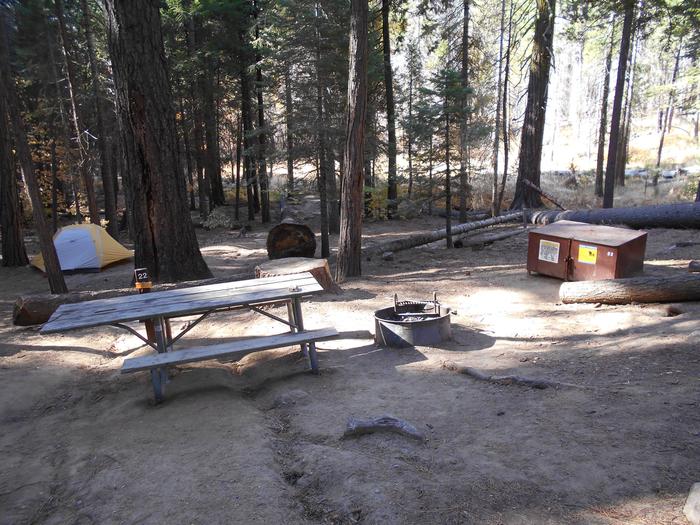
Eagle Creek Campground - Custer Gallatin National Forest Campground
List of CampsitesOverview
Eagle Creek Campground is located 2 miles northeast of the town of Gardiner on Jardine Road and approximately 55 miles south of the city of Livingston along scenic HWY 89 S. At an elevation of 6100 feet, the campground overlooks Yellowstone National Park's majestic peaks. This 16-site campground has gravel roads with unpaved sites that accommodate a maximum of 48’ RVs. The Yellowstone River Trailhead is also located within this campground. Vault toilets, fire rings, picnic tables, and horse corrals are provided to the public. There are no hook-ups available. Food storage order is in effect from March 1st through December 1st.
Recreation
The Yellowstone River Trailhead is located within the camground. There are horse corrals for use by campers and day users. Many other hiking opportunities are locted within a 15 minute drive. The Yellowstone River is close by with access to rafting and fishing activites.
Facilities
Eagle Creek campground offers 16 sites for use by RV or tents. 14 sites are single sites, two sites are double sites. Two sites are first come first serve and are located adjacent to horse corrals. Not all sites are level. There are no hook-ups available. There is no water or sewer dump located close to the campground. Food storage restrictions are in effect from March 1st through December 1st. Bear boxes are located at each site to store food and other bear attractants.
Natural Features
The campground is located at about 6100 feet overlooking the Gallatin Mountains. There is a small creek that runs along the west side of the campground filled with small Aspen trees. It is not uncommon to have Elk roaming through and bedding in the grass.
Nearby Attractions
The Northwest entrance to Yellowstone National Park is located about a 10 minute drive away and offers unparalleled wildlife viewing opportunities, breathtaking scenery and unique geological features. Soak and relax at Yellowstone Hotsprings resort situated in the nearby town of Corwin Springs.
Eldridge Guard Station Campground
List of CampsitesOverview
Eldridge Guard Station is a primitive, rustic, log structure open year-round for recreational enjoyment. It provides access to several trails for summer hiking and biking, and winter skiing and snowmobiling. The cabin can be accessed by vehicle in warmer weather, but snow conditions may require a two mile trek on skis, snowshoes, or by snowmobile.
Guests are responsible for their own travel arrangements and safety, and they must bring several of their own amenities.
Recreation
The area surrounding Eldridge Guard Station offers many recreational opportunities, both motorized and non-motorized. In the summer, visitors can enjoy hiking and mountain biking on the nearby trails, riding 50” (or narrower) motorized vehicles on the motorized trails, stream fishing, or bird/wildlife watching. In the winter, visitors can enjoy snowmobiling, cross-country or back-country skiing, and snowshoeing.
Please note: Fall hunting season brings big game hunters to this area (September 1-December 1).
Facilities
Eldridge Guard Station sleeps 6, with a maximum group size of 8 people for overnight use. 7-night maximum stay per group.
This is a primitive cabin with limited seasonal access - There is no electricity or potable water available (water from nearby creek or snow in winter can be filtered for use). An outhouse is located outside, behind the cabin. A corral is available for stock. A wood stove is available for heat, and a propane gas stove for cooking. There is also a small propane powered refrigerator in the cabin. (Please carefully read the instructions for the propane stove and refrigerator!) The cabin is stocked with basic amenities: axe, shovel, bucket, 2 cots, 2 full-size futons with mattresses, table and chairs, and minimal cookware. A large stock pot is available for boiling water. It is strongly advised that renters bring their own backcountry cookware and dishes for use. Renters should also bring their own firewood, drinking water, flashlight/lantern, bedding, matches, extra toilet paper, garbage bags, dish soap, and other necessities.
Please note: This rustic, uninsulated, high ceiling cabin can be very cold in winter, even with the wood stove burning. Firewood is not provided until Oct 1 (Oct 1 - May 31) – please bring or gather your own firewood from June 1 - Sep 30.
Please be sure to clean the cabin and remove all trash prior to your departure!
Natural Features
Eldridge Guard Station is situated between the Madison Mountain Range and the Gallatin Mountain Range at an elevation of 7,030 feet. The cabin is at the edge of a meadow with Taylor Creek running across from the cabin. Eldridge Guard Station is located in high-population grizzly bear habitat. The area is also home to deer, elk, moose, and other wildlife. Please respect the wildlife and always keep a safe distance. Carry bear spray, and always securely store food and other attractants (March 1-December 1).
contact_info
This location is unstaffed. To speak with our main office for general information, please call: (406) 823-6961.Nearby Attractions
Eldridge Guard Station is within an hour’s drive south to West Yellowstone, Montana, home of the West Gate to Yellowstone National Park. It is also close to Hebgen and Earthquake lakes, as well as the Earthquake Lake Visitor Center.
Eldridge Guard Station is also within an hour’s drive north to Big Sky, Montana.
BASIN MONTANA CAMPGROUND Campground
List of CampsitesOverview
Basin Campground is located 7 miles west of Red Lodge, Montana, along Forest Road 2071, which is paved all the way to the campground. The area is a popular location for hiking, backpacking and fishing.
Recreation
Fishing is a popular activity along the West Fork of Rock Creek and at nearby Wild Bill Lake. The small lake is open to kayaking and canoeing, and an accessible fishing dock is located on the shore.The Basin Lakes Trailhead is just across the road. Silver Run Plateau, West Fork and Timberline Lakes Trails offer access to the Absaroka-Beartooth Wilderness.
Mountain bikers enjoy the Ingles Creek Trail and a variety of loop trails at Silver Run. Biking is also allowed on the Basin Lakes Trail.
Facilities
The campground offers several single-family sites, three of which are accessible. Each site is equipped with a picnic table and campfire ring with grill. Accessible vault toilets and drinking water are provided. Back-in spurs are medium length.Natural Features
The campground is situated on the banks of the West Fork of Rock Creek. The campground and the area surrounding the campground were burned by the Cascade Fire in 2008, leaving an open landscape abounding with wildflowers.contact_info
For facility specific information, please call (928) 537-8888.Nearby Attractions
The charming town of Red Lodge, Montana offers a variety of dining and lodging options, galleries, shops and summer events. The Home of Champions Rodeo is held on Fourth of July weekend, Beartooth Bike Rally and Iron Horse Rodeo in mid-July, Mountain Man Rendezvous in late July and the Festival of Nations in early August.The Beartooth Highway was deemed "the most beautiful drive in America" by the late Charles Kuralt. It snakes across the rugged Beartooth Mountains from Red Lodge to Cooke City, Montana, and is the highest elevation highway in the Northern Rockies. Along the way, visitors are treated to sweeping views and plentiful outdoor recreation opportunities.
Charges & Cancellations
Refunds: Refund requests made through www.recreation.gov will be charged a $10 processing fee. This cancellation processing fee is retained by the reservation service contractor along with the non-refundable reservation fee. All requests for the return of the non-refundable reservation fee and the cancellation processing fee will be declined by the campground concessionaire as they did not receive these fees (these are the fees retained by the reservation contractor, a different entity).
GREENOUGH LAKE Campground
List of CampsitesOverview
Greenough Lake Campground is within walking distance of its namesake, 12 miles south of Red Lodge, in southern Montana. It is located just off the scenic Beartooth Highway. The area is a popular location for fishing, hiking and scenic driving. Glacier Lake, Hellroaring and Lake Fork trailheads are nearby.
Recreation
Greenough Lake offers canoeing, kayaking and rainbow trout fishing. The Main Fork of Rock Creek is also a popular fishing stream.The Beartooth Wilderness can be accessed via the Hellroaring and Lake Fork trailheads, both of which are not far from the campground. Visitors also enjoy mountain biking and hiking on the Parkside National Recreation Trail. Hellroaring Road is open to off-road vehicles.
Facilities
The campground offers single-family campsites, two of which are accessible. Each site is equipped with a picnic table and campfire ring. Accessible vault toilets and hand-pumped drinking water are provided.Natural Features
The campground sits in the shadow of the Beartooth Range, on the banks of Rock Creek, less than a quarter-mile from beautiful Greenough Lake. A forest of aspen and pine trees covers the area. A variety of wildlife, including grizzly bears, deer and elk, makes its home in the surrounding area.Nearby Attractions
The charming town of Red Lodge, Mont., offers a variety of dining and lodging options, galleries, shops and annual summer events. The Home of Champions Rodeo is held on the Fourth of July weekend, the Beartooth Bike Rally and Iron Horse Rodeo take place in mid-July, the Mountain Man Rendezvous is in late July, and the Festival of Nations happens in early August.The Beartooth Highway was deemed "the most beautiful drive in America," by the late Charles Kuralt. It snakes across the rugged Beartooth Mountains from Red Lodge to Cooke City. It is the highest elevation highway in the Northern Rockies. Along the way, visitors are treated to sweeping views and plentiful opportunities for outdoor recreation.
Yellowstone National Park's northeast entrance is 55 miles from the campground, via the Beartooth Highway. The park offers unparalleled wildlife viewing opportunities, as well as breathtaking scenery and unique geological features.
contact_info
For facility specific information, please call (928) 537-8888.Charges & Cancellations
Refunds: Refund requests made through www.recreation.gov will be charged a $10 processing fee. This cancellation processing fee is retained by the reservation service contractor along with the non-refundable reservation fee. All requests for the return of the non-refundable reservation fee and the cancellation processing fee will be declined by the campground concessionaire as they did not receive these fees (these are the fees retained by the reservation contractor, a different entity).
LIMBER PINE Campground
List of CampsitesOverview
Limber Pine Campground is located 12 miles south of Red Lodge, in southern Montana. It is just off the scenic Beartooth Highway. The area is a popular location for fishing, hiking and scenic driving. Greenough Lake is a half-mile away. Glacier Lake, Hellroaring and Lake Fork trailheads are nearby.
Recreation
The Main Fork of Rock Creek and nearby 5-acre Greenough Lake offer rainbow trout fishing. The lake is also open to canoeing and kayaking.The Beartooth Wilderness can be accessed nearby, via the Hellroaring and Lake Fork trailheads. Visitors also enjoy mountain biking and hiking on the Parkside National Recreation Trail. Hellroaring Road is open to off-road vehicles.
Facilities
The campground offers single-family campsites. Each site is equipped with a picnic table and campfire ring. Accessible vault toilets and hand-pumped drinking water are provided. Trash can be deposited in receptacles at the Greenough Lake Campground.Natural Features
The campground sits in the shadow of the Beartooth Range on the banks of Rock Creek. A forest of aspen and pine covers the area. A variety of wildlife, including grizzly bears, deer and elk, makes its home in the surrounding area.Nearby Attractions
The charming town of Red Lodge, Mont., offers a variety of dining and lodging options, galleries, shops and annual summer events. The Home of Champions Rodeo is held on Fourth of July weekend, Beartooth Bike Rally and Iron Horse Rodeo take place in mid-July, the Mountain Man Rendezvous is in late July and the Festival of Nations happens in early August.The Beartooth Highway was deemed "the most beautiful drive in America," by the late Charles Kuralt. It snakes across the rugged Beartooth Mountains from Red Lodge to Cooke City. It is the highest elevation highway in the Northern Rockies. Along the way, visitors are treated to sweeping views and plentiful opportunities for outdoor recreation.
Yellowstone National Park's northeast entrance is 55 miles from the campground, via the Beartooth Highway. The park offers unparalleled wildlife viewing opportunities, as well as breathtaking scenery and unique geological features.
contact_info
For facility specific information, please call (928) 537-8888.Charges & Cancellations
Refunds: Refund requests made through www.recreation.gov will be charged a $10 processing fee. This cancellation processing fee is retained by the reservation service contractor along with the non-refundable reservation fee. All requests for the return of the non-refundable reservation fee and the cancellation processing fee will be declined by the campground concessionaire as they did not receive these fees (these are the fees retained by the reservation contractor, a different entity).
PARKSIDE Campground
List of CampsitesOverview
Parkside Campground is located 12 miles south of Red Lodge, Montana, just off the scenic Beartooth Highway.
The area is a popular location for fishing, hiking and scenic driving. Greenough Lake less than a mile away. Glacier Lake, Hellroaring and Lake Fork Trailheads are nearby.
Recreation
The Main Fork of Rock Creek and nearby 5-acre Greenough Lake offer rainbow trout fishing. The lake is also open to canoeing and kayaking.The Beartooth Wilderness can be accessed via the Hellroaring and Lake Fork Trailheads, both nearby. Visitors also enjoy mountain biking and hiking on the Parkside National Recreation Trail. Hellroaring Road is open to off-road vehicles.
Facilities
The campground offers two group sites and several single-family sites, three of which are accessible. Picnic tables and campfire rings are provided, as are accessible vault toilets and drinking water. Trash can be deposited at the Greenough Lake Campground.Natural Features
The campground sits in the shadow of the Beartooth Range on the banks of Rock Creek. A forest of aspen and pine covers the area. A variety of wildlife, including grizzly bear, deer and elk, make their home in the surrounding area.contact_info
For facility specific information, please call (928) 537-8888.Nearby Attractions
The charming town of Red Lodge, Montana offers a variety of dining and lodging options, galleries, shops and summer events. The Home of Champions Rodeo is held on the Fourth of July weekend, Beartooth Bike Rally and Iron Horse Rodeo in mid-July, Mountain Man Rendezvous in late July and the Festival of Nations in early August.The Beartooth Highway was deemed "the most beautiful drive in America" by the late Charles Kuralt. It snakes across the rugged Beartooth Mountains from Red Lodge to Cooke City, Montana, and is the highest elevation highway in the Northern Rockies. Along the way, visitors are treated to sweeping views and plentiful outdoor recreation opportunities.
Yellowstone National Park's Northeast Entrance is 55 miles from the campground via the Beartooth Highway. The park offers unparalleled wildlife viewing opportunities, as well as breathtaking scenery and unique geological features.
Charges & Cancellations
Refunds: Refund requests made through www.recreation.gov will be charged a $10 processing fee. This cancellation processing fee is retained by the reservation service contractor along with the non-refundable reservation fee. All requests for the return of the non-refundable reservation fee and the cancellation processing fee will be declined by the campground concessionaire as they did not receive these fees (these are the fees retained by the reservation contractor, a different entity).
RATTIN CAMPGROUND Campground
List of CampsitesOverview
Rattin Campground is located 7 miles south of Red Lodge, Montana, just off the scenic Beartooth Highway. The area is a popular location for fishing, hiking and scenic driving.
Recreation
The Main Fork of Rock Creek offers rainbow trout fishing. Greenough Lake is 8 miles away and is a popular area for canoeing, kayaking and fishing.The Beartooth Wilderness can be accessed via the Hellroaring and Lake Fork Trailheads, both of which are nearby. Beartrack and Corral Creek Trailheads are close by as well.
Visitors also enjoy mountain biking and hiking on the Parkside National Recreation Trail. Hellroaring Road is open to off-road vehicles.
Facilities
This small campground offers single-family sites. Picnic tables and campfire rings with grills are provided, as are accessible vault toilets and drinking water.Natural Features
The campground sits in the shadow of the Beartooth Range on the banks of Rock Creek. A forest of aspen and pine covers the area. A variety of wildlife, including grizzly bear, deer and elk, make their home in the surrounding area.Nearby Attractions
The charming town of Red Lodge, Montana offers a variety of dining and lodging options, galleries, shops and summer events. The Home of Champions Rodeo is held on the Fourth of July weekend, Beartooth Bike Rally and Iron Horse Rodeo in mid-July, Mountain Man Rendezvous in late July and the Festival of Nations in early August.The Beartooth Highway was deemed "the most beautiful drive in America" by the late Charles Kuralt. It snakes across the rugged Beartooth Mountains from Red Lodge to Cooke City, Montana, and is the highest elevation highway in the Northern Rockies. Along the way, visitors are treated to sweeping views and plentiful outdoor recreation opportunities.
Yellowstone National Park's Northeast Entrance is 60 miles from the campground via the Beartooth Highway. The park offers unparalleled wildlife viewing opportunities, as well as breathtaking scenery and unique geological features.
contact_info
For facility specific information, please call (928) 537-8888.Charges & Cancellations
Refunds: Refund requests made through www.recreation.gov will be charged a $10 processing fee. This cancellation processing fee is retained by the reservation service contractor along with the non-refundable reservation fee. All requests for the return of the non-refundable reservation fee and the cancellation processing fee will be declined by the campground concessionaire as they did not receive these fees (these are the fees retained by the reservation contractor, a different entity).
SHERIDAN Campground
List of CampsitesOverview
Sheridan Campground is located seven miles south of Red Lodge, in southern Montana. It is just off the scenic Beartooth Highway. The area is a popular location for fishing, hiking and scenic driving.
Recreation
The Main Fork of Rock Creek offers rainbow trout fishing. Greenough Lake is eight miles away, and is a popular area for canoeing, kayaking and fishing.The Beartooth Wilderness can be accessed via the Hellroaring and Lake Fork trailheads, both nearby. Beartrack and Corral Creek trailheads are not far from the campground as well. Visitors also enjoy mountain biking and hiking on the Parkside National Recreation Trail. Hellroaring Road is open to off-road vehicles.
Facilities
This small campground offers single-family sites. Picnic tables and campfire rings with grills are provided, as are accessible vault toilets and drinking water.Sites 5 through 8 are 30 feet in length or less; the turnaround is tight for trailers and RVs. Campsites 1 and 2 are level and suitable for those with limited mobility but do no fully meet accessibility standards, while site 9 supports established accessibility standards.
Natural Features
The campground sits in the shadow of the Beartooth Range, on the banks of Rock Creek. A forest of aspen and pine covers the area. A variety of wildlife, including grizzly bear, deer and elk, makes its home in the surrounding area.contact_info
For facility specific information, please call (928) 537-8888.Nearby Attractions
The charming town of Red Lodge, Mont., offers a variety of dining and lodging options, galleries, shops and annual summer events. The Home of Champions Rodeo is held on the Fourth of July weekend, Beartooth Bike Rally and the Iron Horse Rodeo take place in mid-July, the Mountain Man Rendezvous occurs in late July, and the Festival of Nations is in early August.The Beartooth Highway was deemed "the most beautiful drive in America," by the late Charles Kuralt. It snakes across the rugged Beartooth Mountains from Red Lodge to Cooke City. It is the highest elevation highway in the Northern Rockies. Along the way, visitors are treated to sweeping views and plentiful opportunities for outdoor recreation.
Yellowstone National Park's northeast entrance is 60 miles from the campground, via the Beartooth Highway. The park offers unparalleled wildlife viewing opportunities, as well as breathtaking scenery and unique geological features.
Charges & Cancellations
Refunds: Refund requests made through www.recreation.gov will be charged a $10 processing fee. This cancellation processing fee is retained by the reservation service contractor along with the non-refundable reservation fee. All requests for the return of the non-refundable reservation fee and the cancellation processing fee will be declined by the campground concessionaire as they did not receive these fees (these are the fees retained by the reservation contractor, a different entity).
RAINBOW POINT CAMPGROUND Campground
List of CampsitesOverview
Rainbow Point Campground is located on the banks of scenic Hebgen Lake, in southwestern Montana. It is approximately 10 miles north of West Yellowstone and the West Entrance of Yellowstone National Park. Visitors enjoy the area for its boating, fishing and hiking opportunities, as well as its close proximity to Yellowstone.Recreation
Hebgen Lake is considered Montana's premier still-water fishing lake. Anglers will find a healthy population of brown, cutthroat and rainbow trout. Boating and swimming are popular activities on the lake. A boat ramp is located within the campground.Hiking, biking and off-road vehicle trails crisscross the surrounding area.
Facilities
The campground offers several single-family campsites, many of which have electric hookups. Sites are equipped with a picnic table and campfire ring. Vault toilets and drinking water are provided. Firewood is available for purchase within the campground.Natural Features
Hebgen Lake sits on the Madison River, at an elevation of 6,240 feet. The lake covers 21 square miles and has 65 miles of shoreline. Rainbow Point is situated on Rainbow Bay, among a dense forest of lodgepole pine.A variety of waterfowl is often spotted in the area, including sandhill cranes, herons, Western grebes, white pelicans, osprey, Canada geese, mallards, wood ducks, loons and bald and golden eagles. Bison, deer and moose are frequently seen as well.
contact_info
This location has limited staffing. Please call (661) 702-1420 for general information.Nearby Attractions
West Yellowstone offers dining, shopping and lodging options. The Grizzly and Wolf Discovery Center is a popular attraction with live grizzlies, gray wolves and birds of prey, and a variety of educational exhibits and programs.Yellowstone National Park offers unparalleled wildlife viewing opportunities, breathtaking scenery and unique geological features.
BEAVER CREEK CAMPGROUND Campground
List of CampsitesOverview
Beaver Creek Campground is located near the Madison River and Earthquake Lake, less than 30 minutes from West Yellowstone and Yellowstone National Park. Visitors enjoy the area for its fishing, boating and hiking opportunities, as well as its close proximity to Yellowstone.Recreation
Earthquake Lake offers fishing and canoeing and can be accessed via trails from within the campground, or less than a mile away on the highway. A visitor center is nearby, with interpretive displays, as well as information on the 1959 earthquake and subsequent landslide that formed the lake.Hebgen Lake is considered Montana's premier still-water fishing lake. Anglers will find a healthy population of brown, cutthroat and rainbow trout. Boating and swimming are popular activities on the lake.
The Cabin Creek Trail begins at nearby Cabin Creek Campground. This 6-mile trail is open to hikers and horseback riders.
Facilities
The campground offers several single-family sites, each equipped with a picnic table and campfire ring. Vault toilets, drinking water, food storage lockers and trash collection are provided.Natural Features
The campground is situated on a hillside above the Madison River and Earthquake Lake. Hebgen Lake is also nearby. A forest of pine, Douglas fir and aspen forest the campground. Plentiful grasses and summer wildflowers cover the forest floor.contact_info
This location has limited staffing. Please call (661) 702-1420 for general information.Nearby Attractions
West Yellowstone offers dining, shopping and lodging options. The Grizzly and Wolf Discovery Center is a popular attraction, with live grizzlies, gray wolves and birds of prey, and a variety of educational exhibits and programs.Yellowstone National Park offers unparalleled wildlife viewing opportunities, breathtaking scenery and unique geological features.
WOODBINE CAMPGROUND Campground
List of CampsitesOverview
Woodbine Campground is remotely located adjacent to the Absaroka-Beartooth Wilderness in southwestern Montana, about three hours from Yellowstone National Park via the scenic Beartooth Highway. Red Lodge, Montana is 57 miles east; Nye is 7 miles north.
Recreation
The Stillwater River and nearby streams and lakes offer great fishing opportunities for rainbow, brown and cutthroat trout.Hiking the Woodbine Falls Trail is a popular activity among campers. The 1.5-mile round-trip trail begins in the campground and follows Woodbine Creek before ending at an impressive cascade.
The Stillwater Trail provides access to the Absaroka-Beartooth Wilderness and is open to hiking and horseback riding. The trail reaches beautiful Sioux Charley Lake after 3 miles and continues on another 20+ miles into the wilderness.
Facilities
The campground offers single and group sites, some of which are accessible. Picnic tables and campfire rings with grills are provided, as are accessible vault toilets and drinking water.Natural Features
Woodbine Campground is situated on the banks of the Stillwater River at an elevation of 5,300 feet. The campground is wooded and shady, with views of the surrounding snow-covered, 10,000 foot peaks.A variety of wildlife, including deer, elk and bear, can be found in the surrounding area, creating prime opportunities for wildlife viewing.
contact_info
For facility specific information, please call (928) 537-8888.Nearby Attractions
The Absarokee-Beartooth Wilderness Area is adjacent, boasting 700 miles of trails and hundreds of alpine lakes. The wilderness borders Yellowstone National Park and is a part of the 20-million-acre Greater Yellowstone Ecosystem.The nearby town of Nye hosts Nye Goes Nuts annually in July. The popular event includes food, drinks, children's games and the chicken chase, a crowd favorite.
The small community of Fishtail holds its annual Fishtail Family Fun Day at the end of June, with a pancake breakfast, vendor booths, a parade and live music.
LONESOMEHURST CAMPGROUND Campground
List of CampsitesOverview
Lonesomehurst Campground is located on the banks of scenic Hebgen Lake, just 20 minutes from West Yellowstone, in southwestern Montana. Visitors enjoy the area for its boating, fishing and hiking opportunities, as well as its close proximity to Yellowstone National Park.Recreation
Hebgen Lake is considered Montana's premier stillwater fishing lake. Anglers will find a healthy population of brown, cutthroat and rainbow trout. Boating and swimming are popular activities on the lake. A boat ramp is located within the campground.Hiking, biking and off-road vehicle trails crisscross the surrounding area.
Facilities
The campground offers several single-family sites. Four RV-compatible sites have electric hookups. Picnic tables and campfire rings are provided,as well as vault toilets and drinking water. Firewood is available for purchase from the campground host.Natural Features
Hebgen Lake sits on the Madison River, at an elevation of 6,240 feet. The lake covers 21 square miles and has 65 miles of shoreline. Lonesomehurst is situated on the South Fork Arm of the lake, among lodgepole pines.A variety of waterfowl is often spotted in the area, including Sandhill cranes, herons, Western grebes, white pelicans, osprey, Canada geese, mallards, wood ducks, loons and bald and golden eagles. Bison, deer and moose are frequently seen as well.
Nearby Attractions
West Yellowstone offers dining, shopping and lodging options. The Grizzly and Wolf Discovery Center is a popular attraction with live grizzlies, gray wolves and birds of prey, and a variety of exhibits and educational programs.Yellowstone National Park offers unparalleled wildlife viewing opportunities, breathtaking scenery and unique geological features.
contact_info
This location has limited staffing. Please call (661) 702-1420 for general information.CABIN CREEK CAMPGROUND Campground
List of CampsitesOverview
Cabin Creek Campground is located near the Madison River, in southwestern Montana. It is just 25 minutes from West Yellowstone and Yellowstone National Park's west entrance. Visitors enjoy the area for its fishing, boating and hiking opportunities, as well as its close proximity to Yellowstone.Recreation
The Cabin Creek Trail begins at the campground. The 6-mile trail is open to hikers and horseback riders.Earthquake Lake can be accessed less than three miles from the campground. Fishing and canoeing are popular activities there. A visitor center is nearby, with interpretive displays and information on the 1959 earthquake and subsequent landslide that formed the lake on the Madison River.
Hebgen Lake is considered Montana's premier still-water fishing lake. Anglers will find a healthy population of brown, cutthroat and rainbow trout. Boating and swimming are popular activities on the lake.
Facilities
The campground offers several single-family sites. Each site is equipped with a picnic table and campfire ring. Vault toilets and drinking water are provided.Natural Features
The campground is situated across the road from the Madison River, between Hebgen and Earthquake Lakes. A mature pine and Douglas fir forest covers the campground, where plentiful grasses and summer wildflowers cover the forest floor.Nearby Attractions
West Yellowstone offers dining, shopping and lodging options. The Grizzly and Wolf Discovery Center is a popular attraction with live grizzlies, gray wolves and birds of prey, and a variety of educational exhibits and programs.Yellowstone National Park offers unparalleled wildlife viewing opportunities, breathtaking scenery and unique geological features.
RED CLIFF CAMPGROUND Campground
List of CampsitesOverview
Red Cliff Campground is located in the scenic Gallatin Canyon, on the Bozeman Ranger District of the Gallatin National Forest, in Montana. Bozeman is 46 miles north of the campground and West Yellowstone is 45 miles south. The campground is adjacent to the Gallatin River and Highway 191.The surrounding area offers many outdoor recreational opportunities, including fishing, rafting, hiking and viewing local wildlife.
Recreation
Great opportunities for hiking, fishing, scenic driving and wildlife viewing are available around the campground. Anglers cast for rainbow, brown, brook and cutthroat trout, whitefish and Arctic grayling on the Gallatin River. Rafting and kayaking are popular activities as well.The Elkhorn Creek Trail, for hiking and horseback riding, begins at the south end of the campground.
Facilities
The campground offers single-family campsites, with and without electric hookups. Several sites are also accessible. A day-use group picnic area is available on-site as well, and can accommodate up to 60 people. Vault toilets and drinking water are provided. Roads and parking spurs within the campground are gravel.Natural Features
The campground sits next to the Gallatin River, at an elevation of 6,200 feet. Most campsites are situated among scattered pine and fir trees. Some sites are located in open meadows further from the river.A variety of wildlife makes its home in this scenic canyon. Visitors can often glimpse bald eagles, bighorn sheep, moose, elk, mountain goats, deer and coyotes. Black and grizzly bears also live in the canyon.
contact_info
This location has limited staffing. Please call (661) 702-1420 for general information.Nearby Attractions
The west entrance to Yellowstone National Park is located 45 miles south of the campground, in the town of West Yellowstone. Visitors enjoy day trips to the park for unparalleled wildlife viewing, beautiful scenery and unique geologic features.The Grizzly and Wolf Discovery Center in the town of West Yellowstone is a popular attraction. It showcases live grizzly bears, gray wolves and various birds of prey, and has a variety of exhibits and educational programs.
MOOSE CREEK GROUP SITE Campground
List of CampsitesOverview
Moose Creek Group Site is located in the scenic Gallatin Canyon on the Bozeman Ranger District of the Gallatin National Forest of Montana. It is 32 miles south of Bozeman.The surrounding area offers many outdoor recreational opportunities, including fishing, rafting, hiking and viewing local wildlife.
Recreation
Great opportunities for hiking, fishing, scenic driving and wildlife viewing are available around the campground. Anglers cast for rainbow, brown, brook and cutthroat trout, whitefish and Arctic grayling on the Gallatin River. Rafting and kayaking are popular activities as well.Many trails can be found in Gallatin Canyon. The Swan Creek Trail begins at nearby Swan Creek Campground. Golden Trout Lakes Trail begins about 15 minutes away up Portal Creek Road, three miles south of the campground.
Facilities
Moose Creek is available for group picnicking or camping and can accommodate up to 90 people. Picnic tables and campfire rings are provided, as are vault toilets. Drinking water and trash collection are not available at the campground.Natural Features
The group site sits next to the Gallatin River and Moose Creek, just off Highway 191, at an elevation of 5,700 feet. The site is partly surrounded by pine and fir trees.A variety of wildlife makes its home in this scenic canyon. Visitors can often glimpse bald eagles, bighorn sheep, moose, elk, mountain goats, deer and coyotes. Black and grizzly bears also live in the canyon.
MOOSE CREEK FLAT CAMPGROUND Campground
List of CampsitesOverview
Moose Creek Flat Campground is located in scenic Gallatin Canyon on the Bozeman Ranger District of the Gallatin National Forest, in Montana. It is 32 miles south of Bozeman.The surrounding area offers many outdoor recreational opportunities, including fishing, rafting, hiking and viewing local wildlife.
Recreation
The surrounding area provides great opportunities for hiking, fishing, scenic driving and wildlife viewing. Anglers cast for rainbow, brown, brook and cutthroat trout, whitefish and Arctic grayling on the Gallatin River. An accessible fishing dock is located at the river's edge. Rafting and kayaking are popular activities as well.Many trails can be found in Gallatin Canyon. The Swan Creek Trail begins at nearby Swan Creek Campground. Golden Trout Lakes Trail begins about 15 minutes away up Portal Creek Road, three miles south of the campground.
Facilities
This fully accessible campground offers several single-family campsites, each equipped with a picnic table and campfire ring. A GROUP PICNIC AREA (SITE 14) for DAY USE ONLY equipped with 3 standard size picnic tables is also available and can accommodate up to 50 people.
Vault toilets, drinking water and trash collection are provided. Roads within the campground are paved, but the parking spurs are gravel.
Natural Features
The campground sits next to the Gallatin River near Moose Creek, just off Highway 191, at an elevation of 5,700 feet. A forest of pine and fir trees covers the surrounding mountainsides, but the campground itself lies in an open meadow.A variety of wildlife makes its home in this scenic canyon. Visitors can often catch a glimpse of bald eagles, bighorn sheep, moose, elk, mountain goats, deer and coyotes. Black and grizzly bears also live in the canyon.
contact_info
This location has limited staffing. Please call (661) 702-1420 for general information.SWAN CREEK CAMPGROUND Campground
List of CampsitesOverview
Swan Creek Campground is located in the scenic Gallatin Canyon, on the Bozeman Ranger District of the Gallatin National Forest, in southwestern Montana. It is 31 miles south of Bozeman.The surrounding area offers many outdoor recreational opportunities, including fishing, rafting, hiking and viewing local wildlife.
Recreation
Great opportunities for hiking, fishing, scenic driving and wildlife viewing are available in the area surrounding the campground. Anglers cast for rainbow, brown, brook and cutthroat trout, whitefish and Arctic grayling on the Gallatin River. Rafting and kayaking are popular activities as well.Many trails can be found in Gallatin Canyon. The Swan Creek Trail begins within the campground. Golden Trout Lakes Trail begins up nearby Portal Creek Road, five miles south of the campground.
Facilities
The campground offers single-family campsites. Vault toilets, drinking water and trash collection are provided. Roads within the campground are paved, but parking spurs are gravel. Firewood is available at Greek Creek Campground for $6.00 per bundle.Natural Features
The campground sits next to scenic Swan Creek, a tributary of the Gallatin River. It is just off Highway 191, at an elevation of 5,800 feet. A beautiful, dense forest of spruce and fir trees covers the campground.A variety of wildlife makes its home in this scenic canyon. Visitors can often glimpse bald eagles, bighorn sheep, moose, elk, mountain goats, deer and coyotes. Black bears and grizzly bears also live in the canyon.
contact_info
This location has limited staffing. Please call (661) 702-1420 for general information.CHISHOLM CAMPGROUND Campground
List of CampsitesOverview
Chisholm Campground is located next to scenic Hyalite Reservoir in the Bozeman Ranger District of the Gallatin National Forest, 18 miles south of Bozeman, Montana.The surrounding area offers many outdoor recreational opportunities, including boating, canoeing, fishing, hiking and climbing.
Recreation
Hyalite Reservoir offers many recreational activities, including boating, canoeing and fishing opportunities. Anglers fish for Yellowstone cutthroat, Arctic grayling and brook trout. Hyalite Creek and the East Fork offer fishing as well.Many hiking trails are found in Hyalite Canyon, including the popular Hyalite Peak Trail. This 7.5-mile one-way trail gains 3,450 feet in elevation as it climbs past numerous waterfalls, to beautiful Hyalite Lake and Peak.
Facilities
Natural Features
The campground is situated in a forest of pine and fir trees, next to Hyalite Reservoir, at an elevation of 6,700 feet. The East Fork Hyalite Creek runs alongside the north side of the campground.contact_info
This location has limited staffing. Please call (661) 702-1420 for general information.GREEK CREEK CAMPGROUND Campground
List of CampsitesOverview
Greek Creek Campground is located in scenic Gallatin Canyon, in the Bozeman Ranger District of the Gallatin National Forest. It is 30 miles south of the city of Bozeman, Montana.The surrounding area offers many outdoor recreational opportunities, including fishing, rafting, hiking and viewing local wildlife.
Recreation
Great opportunities for hiking, fishing, scenic driving and wildlife viewing are available around the campground. Anglers cast for rainbow, brown, brook and cutthroat trout, whitefish and Arctic grayling on the Gallatin River. Rafting and kayaking are popular activities as well.Many trails can be found in Gallatin Canyon. The Swan Creek Trail begins at nearby Swan Creek Campground. Golden Trout Lakes Trail begins near the Portal Creek Road, about six miles south of the campground.
Facilities
The campground offers single-family campsites, each equipped with a picnic table and campfire ring. Vault toilets, drinking water and trash collection are provided. Roads within the campground are paved, while parking spurs are gravel.
Natural Features
The campground sits just off Highway 191 at an elevation of 5,600 feet. A beautiful forest of spruce, fir and cottonwood trees covers most of the campground.A variety of wildlife makes its home in this scenic canyon. Visitors can often glimpse bald eagles, bighorn sheep, moose, elk, mountain goats, deer and coyote. Black and grizzly bears also live in the canyon.
contact_info
This location has limited staffing. Please call (661) 702-1420 for general information.HOOD CREEK CAMPGROUND Campground
List of CampsitesOverview
Hood Creek Campground is located next to scenic Hyalite Reservoir, on the Bozeman Ranger District of the Gallatin National Forest. It is 17 miles south of the city of Bozeman, Mont. The surrounding area offers many outdoor recreational opportunities, including boating, canoeing, fishing, hiking and climbing.Recreation
Hyalite Reservoir offers many recreational activities, including boating, canoeing and fishing. Anglers fish for Yellowstone cutthroat, Arctic grayling and brook trout. Hyalite Creek offers fishing as well.Many hiking trails are found in Hyalite Canyon, including the popular Hyalite Peak Trail. This 7.5-mile one-way trail gains 3,450 feet in elevation as is climbs past numerous waterfalls to the beautiful Hyalite Lake and Hyalite Peak.
Facilities
The campground offers sites for both overnight camping and day-use picnicking. A GROUP AREA (SITE 28) for overnight camping is also available for reservation, and can accommodate up to 80 people.
Picnic tables and campfire rings are provided, as are vault toilets, drinking water and trash collection. A boat ramp is located on-site. Roads and parking spurs within the campground are gravel.
Natural Features
The campground is situated on the banks of scenic Hyalite Reservoir, at an elevation of 6,700 feet. Some campsites lie in open meadows along the shoreline, while others are located among scattered pine and fir trees.contact_info
This location has limited staffing. Please call (661) 702-1420 for general information.LANGOHR CAMPGROUND Campground
List of CampsitesOverview
Langohr Campground is located in scenic Hyalite Canyon on the Bozeman Ranger District of the Gallatin National Forest. It is located just 12 miles south of Bozeman, Mont.The surrounding area offers many outdoor recreational opportunities, including fishing, hiking and climbing.
Recreation
Hyalite Creek provides great fishing for Yellowstone cutthroat, Arctic grayling and brook trout. Many hiking trails can be found in Hyalite Canyon.Facilities
The campground offers several single-family campsites. A GROUP PICNIC AREA (SITE 20) for DAY USE ONLY is also available and can accommodate up to 50 people. Tables and campfire rings are provided, as are vault toilets, drinking water and trash collection.
Natural Features
The campground sits next to Hyalite Creek, at an elevation of 6,200 feet. Most campsites are situated in open meadows along the creek. Some are located among scattered pine and fir trees.contact_info
This location has limited staffing. Please call (661) 702-1420 for general information.Nearby Attractions
Hyalite Reservoir is just 3.5 miles from the campground. The scenic 206-acre lake offers many recreational activities, including boating, canoeing, fishing, hiking, climbing and picnicking.The popular Hyalite Peak Trail begins near the reservoir. The 7.5-mile one-way trail gains 3,450 feet in elevation as is climbs past numerous waterfalls to beautiful Hyalite Lake and Peak.
SPIRE ROCK CAMPGROUND Campground
List of CampsitesOverview
Spire Rock Campground is located in scenic Gallatin Canyon on the Bozeman Ranger District of the Gallatin National Forest, in southwestern Montana. It is 26 miles south of Bozeman.The surrounding area offers many outdoor recreational opportunities, including fishing, rafting, hiking and viewing local wildlife.
Recreation
Great opportunities for hiking, fishing, scenic driving and wildlife viewing are available around the campground. Anglers cast for rainbow, brown, brook and cutthroat trout, whitefish and Arctic grayling on the Gallatin River. Rafting and kayaking are popular activities as well.The popular Storm Castle Trail begins nearby. This steep, 3-mile one-way trail climbs to Storm Castle Rock, with excellent views of the canyon below. Garnet Mountain Lookout Trail also begins near the campground. The 3.5-mile trail climbs 2,800 feet in elevation, to the lookout.
Facilities
The campground offers single-family campsites, an overnight, GROUP CAMPING AREA (SITE 2), and another GROUP AREA (SITE 12), that can be used for overnight camping or day-use picnicking. Picnic tables and campfire rings are provided, as are vault toilets.
No drinking water is available in the campground. Campers must bring their own water. Roads and parking spurs within the campground are gravel.
Natural Features
The campground sits next to Storm Castle Creek, a tributary of the Gallatin River, at an elevation of 5,600 feet. Most campsites are located along the creek and are surrounded by spruce and fir trees.A variety of wildlife makes its home in the area. Visitors can often glimpse bald eagles, bighorn sheep, moose, elk, mountain goats, deer and coyotes. Black bears and grizzly bears also live in the canyon.
contact_info
This location has limited staffing. Please call (661) 702-1420 for general information.CASCADE Campground
List of CampsitesOverview
Cascade Campground is located 11 miles west of Red Lodge, in southern Montana. It conveniently sits along Forest Road 2071, which is paved for most of the route. The area is a popular location for hiking, backpacking and fishing.
Recreation
Fishing is a popular activity along the West Fork of Rock Creek and at nearby Wild Bill Lake. The small lake is open to kayaking and canoeing, and an accessible fishing dock is located on the shore.The Basin Lakes Trailhead is three miles away, across the road from Basin Campground. Silver Run Plateau, West Fork and Timberline Lakes trails offer access to the Absaroka-Beartooth Wilderness.
Mountain bikers enjoy the Ingles Creek Trail and a variety of loop trails at Silver Run. Biking is also allowed on the Basin Lakes Trail.
Facilities
The campground offers several single-family sites, two of which are accessible. Each site is equipped with a picnic table and campfire ring with grill. Accessible vault toilets and drinking water are provided. Trash may be deposited in receptacles at nearby Basin Campground.Sites 1 and 2 support established accessibility standards.
Natural Features
The campground is situated on the banks of the West Fork of Rock Creek. The area surrounding the campground was burned by the Cascade Fire in 2008, which left many open glades with abundant wildflowers.contact_info
For facility specific information, please call (928) 537-8888.Nearby Attractions
The charming town of Red Lodge, Mont., offers a variety of dining and lodging options, galleries, shops and annual summer events. The Home of Champions Rodeo is held on the Fourth of July weekend, Beartooth Bike Rally and Iron Horse Rodeo take place in mid-July, the Mountain Man Rendezvous is in late July and the Festival of Nations happens in early August.The Beartooth Highway was deemed "the most beautiful drive in America," by the late Charles Kuralt. It snakes across the rugged Beartooth Mountains from Red Lodge to Cooke City. It is the highest elevation highway in the Northern Rockies. Along the way, visitors are treated to sweeping views and plentiful opportunities for outdoor recreation.
Charges & Cancellations
Refunds: Refund requests made through www.recreation.gov will be charged a $10 processing fee. This cancellation processing fee is retained by the reservation service contractor along with the non-refundable reservation fee. All requests for the return of the non-refundable reservation fee and the cancellation processing fee will be declined by the campground concessionaire as they did not receive these fees (these are the fees retained by the reservation contractor, a different entity).
PINE CREEK CAMPGROUND Campground
List of CampsitesOverview
Pine Creek Campground is located approximately 13 miles south of Livingston, and a few miles east of the Yellowstone River and Highway 89, in Montana. Visitors enjoy the area for its hiking and fishing opportunities in a beautiful natural setting.Recreation
Pine Creek offers anglers the opportunity to fish for whitefish, rainbow and brown trout. An accessible fishing dock is located within the campground.Creekside Trail is an accessible nature trail that meanders along Pine Creek for a half-mile in the campground.
The Pine Creek Trailhead offers hiking and horseback riding. Pine Creek Trail climbs five miles up to Pine Creek Lake, a beautiful 32-acre alpine lake. A mile up the trail from the campground, hikers are awarded beautiful views of Pine Creek Falls.
Facilities
The campground offers several single-family campsites, as well as an OVERNIGHT GROUP CAMPING AREA (SITE 26) and GROUP PICNIC AREA (SITE 28) is available for DAY-USE ONLY. Tables and campfire rings are provided, as are vault toilets, drinking water and trash collection.
Natural Features
Pine Creek is situated in the foothills of the Absaroka Mountains in the heart of beautiful Paradise Valley. A forest of mature Douglas fir and spruce trees covers the campground.contact_info
This location has limited staffing. Please call (661) 702-1420 for general information.SNOWBANK CAMPGROUND Campground
List of CampsitesOverview
Snowbank Campground is located on the banks of Mill Creek, approximately 29 miles south of Livingston, in southwestern Montana. Visitors enjoy the area for its scenic natural beauty, and fishing and trail opportunities. This campground is not recommended for RV's over 30' in length.
Recreation
Mill Creek offers anglers the opportunity to fish for whitefish, rainbow, brown and cutthroat trout.A number of hiking trailheads near the campground offer wilderness access, climbing into the Absaroka Range. The 6.3-mile Wicked Ridge Trail begins just outside the campground entrance. Off-road vehicle and bike trails also crisscross the area around Snowbank.
Facilities
The campground offers one GROUP CAMPING AREA (SITE 12) that can accommodate up to 25 people. Single-family sites are also available. Picnic tables and campfire rings are provided, as are vault toilets, drinking water and trash collection. Firewood is available for $6.00 per bundle.
Natural Features
The campground is situated along Mill Creek near the western edge of the Absaroka-Beartooth Wilderness, where a scenic forest of mature spruce and fir trees covers the area. Thimbleberry and raspberry bushes dot the forest floor.contact_info
This location has limited staffing. Please call (661) 702-1420 for general information.IBEX CABIN Campground
List of CampsitesOverview
Ibex Cabin was constructed in 1939 as a shelter for Forest Service rangers working within the Shields Ranger District of the Gallatin National Forest of south-central Montana. It is available for summer and winter recreational use, and provides a peaceful, remote mountain retreat.
Guests can drive to the cabin from June until the snow flies. The cabin is closed April and May due to road and wildlife protection. High clearance, four-wheel drive vehicles are strongly recommended. The access road to the cabin may get muddy in the rain, so guests may want to call ahead for road conditions. In the winter, the cabin is only accessible by a 5.5-mile ski, snowshoe or snowmobile trip. Guests are responsible for their own travel arrangements and safety.
This cabin offers very rustic accommodations with limited amenities, so guests should be
prepared to bring most of their own supplies and gear to make their stay an enjoyable experience.
Recreation
There are a number of trails in the area for hikers, equestrians and snowmobilers. Tresspass Trail and Cottonwood Lake Trail are good trails in the area to explore. Trails in the area may cross private property,so guests MUST stay on the trail.
Winter recreation includes snowshoeing and cross-country skiing. Big game hunting is also a popular activity in this area.
Facilities
The cabin has bunk beds with mattresses to accommodate up to four people. Other amenities include a wood stove for heat, a propane lantern , a propane cookstove, ( bring propane cannisters), table, chairs, axe, splitting maul, bucket, broom, mop and shovel.
An outhouse with vault toilet is located outside.
FIREWOOD IS NOT AVAILABLE FROM JUNE 1ST THROUGH SEPTEMBER 30TH. PLEASE BRING FIREWOOD OR GATHER FROM FOREST DURING SUMMER.
DO NOT BURN PROVIDED FIREWOOD FOR OUTDOOR FIRES, EVER, AS IT IS EXTREMELY DIFFICULT TO REPLACE. Firewood is available during winter months as long as supplies last. A campfire ring is located outside, (collect wood in forest nearby or bring firewood for outside fires).
Electricity and water are not available. Guests must bring their own water supply, as well as cooking gear, propane canisters for the lantern and stove, bedding, matches, newspaper, first aid kit, dishes and utensils, toilet paper and other necessities. The cabin will need to be cleaned and all trash carried out, prior to leaving.
Natural Features
The rustic cabin is nestled at the edge of a meadow in the foothills of the Crazy Mountains, at an elevation of 6,600 feet. A forest of Lodgepole pine grows behind the cabin, and views from the front reveal the 7,354-foot peak of Ibex Mountain. The surrounding meadow bursts with color from wildflowers in the summer. Mule deer, porcupine and elk may be spotted around the cabin. Several bird species that inhabit this area include bald eagles, owls, jays, western meadowlarks and mountain bluebirds.BIG CREEK CABIN Campground
List of CampsitesOverview
The original Big Creek Cabin was built in 1907 and it still stands on this site. The current cabin, a former guard station, was completed in 1925 and sits right next to the original.Big Creek Cabin is the largest cabin in the Yellowstone District, a 28-by-40 log structure with five rooms and two porches. It offers rustic accommodations with limited amenities. Guests will need to bring much of their own gear and supplies.
The cabin is accessible by vehicle when there's no snow, however, four-wheel drive is strongly recommended. In the winter, skis or snowshoes are required to cover the half-mile to the cabin from the plowed road. Guests are responsible for their own travel arrangements and safety.
Recreation
A trailhead is located near the cabin that leads to three different trails for hikers and equestrians. One of these trails heads into the Gallatin Range.Good trout fishing is available in Big Creek. Cross-country skiing and snowshoeing are popular winter pastimes.
Facilities
The cabin is furnished with tables, chairs and enough beds with mattresses to accommodate 11 people (most are bunk beds). A propane lantern, propane two-burner cookstove, wood cook stove and wood
heat stove are also provided. FIREWOOD IS NOT AVAILABLE FROM JUNE 1ST TO SEPTEMBER 30TH. PLEASE BRING FIREWOOD OR GATHER FROM FOREST DURING SUMMER.
DO NOT BURN PROVIDED FIREWOOD FOR OUTDOOR FIRES, EVER, AS IT IS EXTREMELY DIFFICULT TO REPLACE. Firewood is available during winter months as long as supplies last. An axe and a splitting maul should be available. A mop and bucket are provided for cleaning the cabin.
A corral is located across from the cabin, with room for six stock animals. A campfire ring and outhouse with vault toilet are just outside.
Water and electricity are not available. Guests will need to bring their own water supply. Propane fuel for the lantern and cookstove is not provided, so it may be necessary to
bring extra propane or battery-operated lanterns or flashlights. Garbage bags are needed to pack out trash.
For a comfortable stay, guests should bring a propane canister for the lantern and stove, flashlight, bedding, cookware, dishes, utensils, newspaper, garbage bags, matches, toilet paper and first aid kit. Guests are expected to pack out all trash and clean the
cabin and the stock corral (if used) before leaving.
Natural Features
Big Creek Cabin is located in an area known as Paradise Valley, where the peaks of the Gallatin Range fracture the western sky and the Absarokas rise to the east.The cabin sits in a flat clearing surrounded by spruce and fir trees at an elevation of 5,800 feet. Big Creek flows about 50 feet from the back porch. Bears, elk, deer and moose are frequently seen in the vicinity.
PORCUPINE CABIN Campground
List of CampsitesOverview
Porcupine Cabin sits in the foothills of the Crazy Mountains at an elevation of 6,400 feet. It was built in 1914 after a previous structure burned down, and was remodeled by the Civilian Conservation Corps in 1934. Since its construction, the cabin has been used as temporary housing by Forest Service rangers while they were patrolling for timber poachers, watching for fires and monitoring livestock. Today, it is available year-round to outdoor enthusiasts, offering access to a variety of activities.Guests can drive to the cabin in the summer, but a high-clearance, four-wheel drive vehicle is recommended due to road conditions. Winter access requires snowshoeing, skiing or snowmobiling up to 2 miles from the end of the maintained gravel road.
Guests are responsible for their own travel arrangements and safety, and must bring several of their own amenities.
Recreation
Guests can access the nearby trailhead for hiking, mountain biking and equestrian use, heading east into the Crazy Mountains. The trails are used by snowshoers and cross-country skiers in the winter.Facilities
The 26 x 44 frame house has three rooms and a screened front porch. It has bunk beds with mattresses to accommodate up to eight people. It has a table and chairs, some cleaning equipment and a propane lantern available for use. A wood stove is available to heat the cabin.
FIREWOOD IS NOT AVAILABLE FROM JUNE 1ST THROUGH SEPTEMBER 30TH. PLEASE BRING FIREWOOD OR GATHER FROM FOREST DURING SUMMER.
DO NOT BURN PROVIDED FIREWOOD FOR OUTDOOR FIRES, EVER, AS IT IS EXTREMELY DIFFICULT TO REPLACE. Firewood is available for indoor use during winter as long as supplies last. An axe and splitting maul should be available.
An outhouse with vault toilet is located behind the cabin. A campfire ring is out front. (Please bring wood to burn outside).
Water, electricity and propane canisters for the lantern are not provided. Guests need to bring their own drinking water, cooking gear and food, bedding, fire starters (matches and newspaper), extra toilet paper, flashlights, first aid kit, cookware, dishes and utensils, among other necessities. The cabin will need to be cleaned and all trash carried out.
Equestrian trails are located nearby, and a small pasture near the barn is available for cabin renter's stock. Please be aware that the pasture fence may not be secure. Stock is not allowed near the cabin or inside the cabin fence.
Natural Features
The cabin sits on a hillside overlooking the grasslands of Shields Valley. This vantage point provides a majestic view of the Bridger Mountains and spectacular star gazing on a clear night. Guests can look out at the northern peaks of the Crazies from the front porch. Porcupine Cabin offers a quiet and fairly isolated retreat, however, there may be some passing traffic from recreational users accessing the nearby trailhead. Deer, moose, bears and elk may be spotted nearby. Several bird species that inhabit this area include bald eagles, owls, jays, western meadowlarks and mountain bluebirds.MILL CREEK CABIN Campground
List of CampsitesOverview
Mill Creek Cabin was built in 1927 as a temporary lodging for traveling Forest Service personnel.The cabin can be accessed by vehicle year-round, though a four-wheel drive vehicle is recommended. Guests are responsible for their own travel arrangements and safety. This cabin offers rustic accommodations with limited amenities, so guests need to bring most of their own supplies and gear for a comfortable stay.
Recreation
Hikers and equestrians can access trailheads that lead into the Absaroka-Beartooth Wilderness. Anglers can fish for Yellowstone cutthroat trout in Mill Creek. Huckleberry-picking is a popular pastime when in season. Winter recreation includes cross-country skiing, snowshoeing and snowmobiling on the Mill Creek Snowmobile Trail. The cabin also offers easy access to the Snowbank and and Passage Creek Falls ski trails.Facilities
This 20-by-14 log structure has a front and back porch. It has bunk beds with mattresses to accommodate up to four people. Other amenities include a table with chairs, wood-burning stove for heat. It also has an electric range and electric lights. Water is available in the cabin from mid-June to mid-September. FIREWOOD IS NOT AVAILABLE FROM JUNE 1ST THROUGH SEPTEMBER 30TH. PLEASE BRING FIREWOOD OR GATHER FROM FOREST DURING SUMMER. DO NOT BURN PROVIDED FIREWOOD FOR OUTDOOR FIRES, EVER, AS IT IS EXTREMELY DIFFICULT TO REPLACE. Firewood is available for indoor use during winter as long as supplies last. The front porch has a picnic table and benches. A campfire ring( bring your own wood) and outdoor vault toilet are located near the cabin. A corral for up to four horses is located across from the parking area and has running water and a trough during the summer months. Water is not available at the cabin from mid-September through mid-June, so guests need to provide their own drinking water. Guests also need to bring cookware, utensils, bedding, fire starting materials (newspaper and matches), flashlights, first aid supplies and extra toilet paper. The cabin and corrals (if used) should be cleaned and all trash removed prior to leaving.Natural Features
Mill Creek Cabin is tucked into the Absaroka Mountains, at an elevation of 5,750 feet. The cabin sits at the edge of a meadow in front of a stand of evergreens. The back porch overlooks bubbling Mill Creek, a tributary of the Yellowstone River.Deer, elk and black bears are sometimes visitors to this area. Bird species that inhabit this area include bald eagles, owls, jays, western meadowlarks and mountain bluebirds.
TRAIL CREEK CABIN Campground
List of CampsitesOverview
Trail Creek Cabin, built in 1924, was the original ranger station for the Bozeman Ranger District. It is available year round, offering guests the chance to enjoy summer or winter recreation. The cabin is located in a remote area that is not accessible by car or truck. Guests must travel on foot, horseback, motorized vehicle (under 50”) or mountain bike. In winter, skis, snowshoes or snowmobiles may be used to reach the cabin. The best route for arriving on foot or horseback is about 2 miles, while motorized vehicles (under 50”), and snowmobiles have a 5-mile route. Call the district office M-F, 8 to 4:30, for latest road/trail conditions. Check Travel Plan for restrictions and authorized dates. To get to the cabin on motorcycle or ATV via Goose Cr Trail No. 439, the dates allowed are from 6/16 to 12/1 annually. Guests are responsible for their own travel arrangements and safety, and should be prepared to bring supplies and gear they need for a comfortable stay.
Recreation
The cabin is located along a trail system that connects the Yellowstone and Bozeman Districts. A hiking and equestrian trail at the end of Goose Creek Road leads to several alpine lakes. Snowy conditions in winter provide ample opportunities to snowshoers, cross-country skiers and snowmobilers.
As an addition to non-mortorized use, the Trail Creek Cabin provides wonderful opportunites for the motorized use community. In additon to accessing the cabin by atv, motorcyle or utvs under 50", the area has several opportunities for looped riding trials as well as scenic overlooks. This cabin can also be accessed via the Bear Canyon Trail by motorized (under 50") use. Please see Travel Plan for the latest seasonal trail restrictions.
Facilities
The cabin has bunk beds with mattresses to accommodate up to four people. A wood stove is available to heat the cabin. Other amenities include a table with chairs, propane lantern, propane two-burner cookstove, (bring propane canisters), shovel, bucket, mop and broom. The cabin is stocked with firewood from OCTOBER THROUGH MAY for indoor fires only. An axe and splitting maul are provided. Please be conservative of the firewood as it is extremely difficult to replace. Gather firewood for outdoor fires from the forest nearby. Do not use the provided firewood for outdoor fires.
A campfire ring and an outhouse with vault toilet are located outside. A horse corral is provided for four animals, and guests who use it must clean it before leaving. Feed must be weed seed free, and out of state horses must have a current Coggins test. WATER SOURCES ARE UNRELIABLE DUE TO STREAM FLOWS. THERE MAY BE NO NEARBY WATER SOURCE.
The cabin does not offer electricity or water. Guests must bring their own drinking WATER, food, cooking gear and propane canisters for the lantern and cookstove, as well as their own bedding, dishes, utensils, matches, newspaper, flashlights, garbage bags, extra toilet paper, a first aid kit and dish soap, among other necessities. The cabin will need to be cleaned and all trash removed prior to leaving.
Natural Features
The cabin is located in the foothills of the Gallatin Mountains at an elevation of 6,200 feet. It is situated on the edge of a meadow in front of a stand of lodgepole pine. The front porch of the cabin offers views of the meadow with the mountain peaks beyond. A small intermittent creek flows behind the cabin. Guests may catch a glimpse of a bear, moose, elk or deer. Several bird species can also be spotted.MEYERS CREEK CABIN Campground
List of CampsitesOverview
Meyers Creek Cabin is located within the Meyers Creek Work Center in Custer National Forest at an altitude of 5,646 feet. The cabin offers opportunities to enjoy relaxation and recreation in beautiful surroundings. It is reservable from May through November. The cabin is accessible by vehicle. 4-wheel drive is recommended during wet weather.Recreation
Trails crisscross the area, including the Meyers Creek and Lodgepole Creek Trails. This area offers recreation for hikers, mountain bikers and equestrians. Horse facilities are available at the cabin.Anglers can fish for rainbow and brown trout in nearby creeks.
Facilities
This cabin sleeps 6 people and comes equipped with 5 single mattresses, an electric refrigerator, cook stove, heat, indoor toilet and shower, cookware, dishes and utensils. A campfire ring is located outside.There are 2 corrals, a watering tank and hitching rails for horses. Potable water is available, but guests may wish to bring a water filter or provide their own water if they are concerned about quality or taste.
Items such as bedding, towels, washcloths and dish soap are not provided.
Natural Features
The cabin is situated in the western end of the Beartooth Mountains and surrounded by pastures, which are used for grazing cattle. Roses, irises, rhubarb and lilacs grow around the dwelling. The surrounding slopes are covered in pine, aspen and sagebrush, with wildflowers blooming in the summer. This area supports a large bear population ( bear safety ). Bighorn sheep, elk, deer and a variety of bird species also inhabit the mountainous terrain in the Beartooth Ranger District.Nearby Attractions
The Stillwater River Trailhead, with access to the Absaroka/Beartooth Wilderness, is 16 miles south of the cabin.YELLOW MULE CABIN Campground
List of CampsitesOverview
Yellow Mule Cabin was built in 1920 and was once used as a ranger station. This cabin is unique because it was constructed according to the builder's preference instead of being built with a standard Forest Service design. It is eligible for nomination to the National Register of Historic Places. The cabin provides a rustic, backcountry retreat year-round. A few basic amenities are provided, so guests should be prepared to bring most of the supplies and gear they need for an enjoyable experience. This remote cabin is not accessible by car. Summer access is via off-road vehicle, motorcycle or hiking for 8 miles. Winter access is by snowmobile for 14 miles.Recreation
This cabin is popular with snowmobilers because of its proximity to the Buck Creek Ridge Trail, which offers a 1,000 foot elevation gain. Hikers, mountain bikers and off-road vehicle riders enjoy this trail in the summer. Snowmobilers and cross-country skiers can also access McAtee Basin. Hunting in designated areas is another popular pastime.Facilities
This 12 x 14 single-room cabin can sleep up to three people and comes with three cots. A wood stove is provided for heat. Basic cookware, utensils, a propane lantern and a dining table with chairs are available. An outhouse with a vault toilet is located just outside. Water, electricity, cooking facilities and firewood are not provided. Guests must bring their own water supply and trash bags to pack out trash, as well as bedding, matches, first aid supplies, extra toilet paper and battery-operated lanterns or flashlights.Natural Features
The cabin sits between a meadow and a stand of mixed evergreens at an elevation of approximately 8,650 feet. Wildflowers bloom across the meadow in the summer and a thick layer of pristine snow blankets the area in winter. The jagged, glaciated peaks of the Madison Mountain Range stretch out into the distance. Wildlife in this area includes grizzly bear, gray wolf, mountain lion, deer, elk, moose, bighorn sheep and the Canada lynx. Birders may see a wide variety of bird species.WINDY PASS CABIN Campground
List of CampsitesOverview
Windy Pass Cabin was built in 1934. It provides a rustic mountain retreat with few amenities, so guests need to bring most of their own supplies and gear to make their experience comfortable and enjoyable. The cabin is available from June 16th through October 14th each year. It is accessible via a 2.5-mile hike or horseback ride up the Windy Pass Trail with an elevation gain of 1,300 feet.Recreation
The Windy Pass Trail passes by the cabin and takes hikers and equestrians along the ridge and down through the Gallatin Range. Several other trails crisscross the area, including the Gallatin Crest Trail. Hunting in designated areas is also a popular activity.Facilities
The cabin sleeps four people with a set of bunk beds with mattresses downstairs and two beds in the loft. A wood-burning stove provides heat. A table with chairs, cookware and utensils are available. A horse corral and outhouse with vault toilet are located outside. Drinking water, electricity and firewood are not provided. Guests needs to bring their own water supply. Trash bags are needed for packing out garbage, and guests are expected to clean the cabin before leaving. A cook stove is not provided. Visitors should bring items such as bedding, flashlights or lanterns, matches and extra toilet paper.Natural Features
Windy Pass Cabin is located near the Gallatin Crest at approximately 8,900 feet in the Gallatin Mountains. A small stream flows just below it. High alpine meadows dotted with evergreens surround the cabin and fill with colorful wildflowers in July. A short walk to the top of the Gallatin Crest offers views of the distant snow-dusted peaks of the Absarokas and the Yellowstone River to the east and the Madison Range to the west. Grizzly bear, gray wolf, mountain lion, deer, elk, moose, bighorn sheep and the Canada lynx are some of the wildlife that inhabit this area. Birders may see a wide variety of bird species.WINDOW ROCK CABIN Campground
List of CampsitesOverview
Window Rock Cabin was built in 1940 and now offers a year-round retreat for outdoor enthusiasts. It is ideally located in one of Gallatin National Forest's most popular recreation areas.
The cabin is accessible by car in the summer. During the spring (from March 31st through May 15th) the road to the cabin is closed to motorized vehicle traffic every year. Guest should be prepared to hike or bike 12 miles to the cabin during this period.
During winter months the access road is infrequently plowed, so guests should be prepared with a four wheel drive, high clearance vehicle or to ski up to 12 miles to the cabin.
Guests are responsible for their own travel arrangements and safety, and must bring several of their own amenities.
Recreation
Hikers and equestrians have access to the Hyalite Peak trailhead that leads into an area of the Gallatin Range known for its waterfalls. Two accessible trails in Hyalite Canyon lead to the waterfalls. Bicyclists can use Hyalite Canyon Road. Hyalite Canyon is a popular destination for backcountry skiers and ice climbers. Hyalite Reservoir is a mile away, offering opportunities for non-motorized boating and trout fishing. Elk hunting is excellent in Hyalite Canyon in the fall.Facilities
The cabin sleeps four people on twin beds with mattresses. The wood-burning stove can be used for cooking and heating.A table with chairs, broom and dustpan are provided. A campfire ring is located outside. The outhouse has an accessible vault toilet. A horse corral is available with space for six horses. No water or electricity is provided. Guests must bring their own water supply, garbage bags for packing out trash, as well as bedding, lighting, extra toilet paper and matches.Natural Features
Window Rock Cabin is nestled in Hyalite Canyon, an area with beautiful wildflower meadows during the summer and thick blankets of pristine snow in winter. Evergreen forest and the steep ridges of the Gallatin Mountains surround the cabin.Hyalite creek flows nearby. This area is important habitat for grizzly bears, bison, elk, mule deer, mountain lions, bighorn, wolves and mountain goats.SPANISH CREEK CABIN Campground
List of CampsitesOverview
Spanish Creek Cabin was constructed in 1934 and retains much of its rustic character from that time. The cabin is available year-round and offers an excellent base camp for a variety of summer and winter recreation opportunities. It is adjacent to a popular trailhead and a campground. Guests may drive to the cabin during summer months. During the winter (December 2nd through May 15th) the access road is gated 3.5 miles from the cabin and guest should be prepared to hike, bike, ski or snowshoe to the cabin. Guests are responsible for their own travel arrangements and safety, and must bring several of their own amenities.Recreation
A nearby trailhead provides access to a network of trails that head south into the Lee Metcalf Wilderness and west into non-wilderness areas.The trails can be used by hikers, equestrians, snowshoers and cross-country skiers. Trails also lead to Little Hell Roaring Creek, the north end of the Madison Range and the South Fork of Spanish Creek. This area also offers opportunities for fishing and hunting.Facilities
The two-story cabin has bunk beds and beds with mattresses to sleep up to four people. A wood cook stove is provided. In a kitchen area cleaning equipment is available. A campfire ring is located in front of the cabin. An outhouse is equipped with a vault toilet. Electricity and water are not provided. Guests need to bring their own drinking water, bedding, food, lanterns or flashlights, extra toilet paper, dish soap, garbage bags and first aid supplies, among other necessities. The cabin will need to be cleaned and all trash removed before leaving.Natural Features
The cabin sits at the base of the Lee Metcalf Wilderness, in a large meadow, at an elevation of 6,200 feet. Wildflowers add bursts of color around the cabin each summer. South Fork Spanish Creek flows nearby. The densely-forested peaks of the Madison Range surround the cabin. This area is home to grizzly bears, moose, elk, deer and bighorn sheep, as well as a variety of bird species.MYSTIC LAKE CABIN Campground
List of CampsitesOverview
Mystic Lake Cabin was built in 1930 and is currently open year-round. It provides access to a variety of recreational activities, including fishing, hunting and exploration of numerous trails. The cabin is located in a non-motorized area. Guests must be prepared to hike, horseback ride or mountain bike to get there in the summer, and winter access is by cross-country skis or snowshoes. Guests are responsible for their own travel arrangements and safety, and must bring several of their own amenities.Recreation
New World Gulch Trail and Bozeman Creek Trail are just a couple of the multi-use trails in the area for hikers, equestrians, mountain bikers, skiers and snowshoers. The Mystic Lake Loop is popular with mountain bikers. Anglers can fish for brook, rainbow and cutthroat trout in Mystic Lake. Hunting opportunities are good in the fall.Facilities
The cabin has bunk beds with mattresses to sleep up to four people. A wood-burning cook stove also heats the cabin. Other amenities include a table with chairs, basic cookware, dishes and tableware. Firewood is supplied for the stove. Outside is a campfire ring and a corral for up to two horses. An outhouse is equipped with a vault toilet. No electricity or water is available at the cabin. Guests need to bring their own supply of drinking water, as well as items such as fire starters (matches and newspaper), flashlights or lanterns, bedding, extra toilet paper, first aid supplies and dish soap, which are also not provided The cabin will need to be cleaned and all trash removed prior to leaving.Natural Features
The cabin is tucked into a stand of pines near the southeastern shore of Mystic Lake, at an elevation of about 6,400 feet. The landscape surrounding Mystic Lake includes meadows that fill with wildflowers in the summer, as well as evergreen forest and the peaks of the Gallatin Range. Visitors may spot one of the resident black or grizzly bears, moose, elk or mule deer. Several bird species also inhabit the area.LITTLE BEAR CABIN Campground
List of CampsitesOverview
Little Bear Cabin was built in 1938 and still looks much the same as it did back then. It is available year-round for recreationists, as well as for those who seek a quiet mountain retreat. The cabin can be accessed by vehicle during the summer and fall (June 16th - December 31st) weather and snow conditions permitting, but winter access requires snowmobiling or skiing 10 miles from the paved road. Guests are responsible for their own travel arrangements and safety, and must bring several of their own amenities.Recreation
Several multi-use trails and roads crisscross the area, ideal for motorcycle and off-road vehicle riding, mountain biking and hiking. Winter activities include snowshoeing,snowmobiling and cross-country skiing. The area surrounding the cabin is popular with hunters in the fall.Facilities
The cabin has a bunk bed downstairs and two beds in the loft, each with mattresses, to sleep up to four people. There is a wood cook stove which provides some heat, but it may not be sufficient in extremely cold temperatures. A table with chairs, broom,dustpan and snow shovel are provided. A campfire ring and outhouse with vault toilet are located outside the cabin.Water and electricity are not available. Guests must bring their own drinking water, as well as fire starters (matches and newspaper), bedding, dish soap, flashlights or lanterns and extra toilet paper, among other necessities. The cabin must be cleaned and all trash removed prior to leaving.Natural Features
The cabin sits atop a grassy knoll on a small ridge near the north end of the Gallatin Range, offering views of Gallatin Valley and the Bridger Range. Stands of mixed conifer surround the cabin. Wildlife in the surrounding area includes grizzly and black bears, gray wolves, mountain lions, deer, elk, moose, bighorn sheep and Canada lynx. Birders may see a wide variety of bird species.GARNET MOUNTAIN FIRE LOOKOUT Campground
List of CampsitesOverview
Garnet Mountain Fire Lookout sits on the apex of Garnet Mountain, at an elevation of 8,245 feet. The lookout provides a panoramic view of the surrounding peaks and valleys. Highlights include the Spanish Peaks to the west, the Gallatin Range to the south, the Hyalite Ridge to the east and the Gallatin River Valley to the north.
The structure can be accessed by hiking, horseback or mountain bike on the Garnet Mountain Lookout Trail in the summer. The 4.5-mile trail gains 2,800 feet along its path. Motorcycles and ATVs can access the lookout via the Rat Lake Trail from June 16 through December 1. During winter months, guests must plan on skiing, snowmobiling or snowshoeing up to 10 miles.
Guests are responsible for their own travel arrangements and safety, and must bring several of their own amenities.
Recreation
Hikers, mountain bikers and off-road vehicle riders can access the same trail used to get to the lookout. Snowy conditions offer abundant opportunities for cross-country skiing and snowshoeing. Big game hunting for bear, elk or moose is a popular autumn pastime around Garnet Mountain.Facilities
The lookout can sleep up to four people on provided bunk beds with mattresses. There is a wood stove for heat and propane stove for cooking. Other amenities include a table with chairs, basic cookware, dishes and utensils. A vault toilet is located outside the facility. Firewood is provided for the wood stove, and there is a campfire ring outside as well. Water and electricity are not available. Guests must bring their own water supply, as well as garbage bags for packing out trash. Items such as bedding, flashlights or lanterns, dish soap, extra toilet paper and first aid supplies are also not provided.Natural Features
A fire lookout has existed on Garnet Mountain since 1930. The current structure was built in 1962. The lookout is available for reservation year-round. It is an excellent vantage point for watching sunrises and sunsets, or for gazing at the stars on a clear night. Grizzly bears are extremely common in this area, and gray wolves, mountain lions, deer, elk, moose, bighorn sheep and the Canada lynx also make their home here. A wide variety of bird species can also be seen.FOX CREEK CABIN (MT) Campground
List of CampsitesOverview
Fox Creek Cabin is a former ranger station located in a remote area. It is very small and offers only basic amenities. Guests will need to bring most of the gear and supplies they need to have a comfortable and enjoyable stay. The cabin is located in a non-motorized area and can only be accessed by a 2.5-mile hike during the summer months, from the end of Langohr Road. A four-wheel drive vehicle is recommended for driving on Langohr Road. Winter access to the cabin requires hiking, skiing or snowshoeing about six miles from the South Cottonwood Trailhead.Recreation
The South Cottonwood and History Rock Trails are used to access the cabin and are available for hiking, mountain biking, snowshoeing and cross-country skiing, depending on the conditions. Both trails connect to the Mount Blackmore Loop Trail, which offers views of the Hyalite Canyon at the summit of Mount Blackmore before descending to Blackmore Lake. Fishing is possible in the area, as well as hunting in the fall.Facilities
The cabin has bunk beds with mattresses to accommodate up to two people. A small wood stove can be used for heating and cooking. A table with chairs, basic cookware, dishes, utensils and cleaning equipment are provided. An outhouse is equipped with a vault toilet. Electricity and water are not provided. Guests must bring their own water supply and flashlights or lanterns. Guests should also bring their own bedding, dish soap, toilet paper, garbage bags and other supplies. The cabin will need to be cleaned and all trash carried out prior to departure.Natural Features
The cabin sits at an elevation of approximately 6,700 feet, next to South Cottonwood Creek in the midst of the Gallatin Mountain Range. It is situated in a small clearing surrounded by thick evergreen forest, so it is well hidden from the trails used to reach the cabin. The access trails offer scenic views of wildflower meadows and 10,154-foot Mount Blackmore. Wildlife in this area includes grizzly and black bears, gray wolves, mountain lions, deer, elk, moose, bighorn sheep and Canada lynx. Birders may see a wide variety of bird species.Nearby Attractions
BATTLE RIDGE CABIN Campground
List of CampsitesOverview
Battle Ridge Cabin is a rustic dwelling located north of Bozeman, in southwestern Montana. The cabin was built in 1938 and is open year-round. It can be reached by vehicle in the summer, but guests visiting during winter must hike or ski a quarter-mile from the highway to reach the cabin. Guests are responsible for their own travel arrangements and safety, and must bring several of their own amenities.Recreation
This is a popular destination in winter for cross-country skiers and snowshoers. Hikers can find nearby trails. Hunting is a popular activity in the area. This is also an ideal spot for birding and watching other wildlife species.Facilities
Battle Ridge Cabin is wheelchair accessible and has a capacity of up to four to five people. Two sets of bunk beds with mattresses and one cot are provided. A wood cook stove, propane lantern, table and chairs are also provided. A vault toilet is located in an outhouse nearby. A campfire ring is just outside the cabin. No electricity or running water is provided. A spring is located about 500 yards away, but the water should be treated or boiled prior to consumption. Guests need to bring garbage bags to pack out their trash, and they are expected to clean the cabin before leaving. Items such as bedding, dishes, dish soap, dish towels, lanterns or flashlights, extra toilet paper, extra propane and first aid supplies are not available.Natural Features
The cabin sits in a meadow surrounded by the evergreen-forested slopes of the Bridger Mountains, including the 9,004-foot Ross Peak, one of the better-known mountains in the range. The Custer Gallatin National Forest provides habitat for species such as grizzly and black bear, gray wolf, mountain lion, deer, elk, moose, bighorn sheep and the Canada lynx. Birders may see a wide variety of bird species.Nearby Attractions
Bozeman is approximately 20 miles away, offering various dining, shopping or opportunities to get necessary supplies.DIAMOND BUTTE LOOKOUT Campground
List of CampsitesOverview
Diamond Butte Lookout is perched atop a 30-foot masonry tower on Diamond Butte at an altitude of 4,245 feet in the Custer National Forest approximately 40 miles from Ashland, Montana. The lookout was moved from its original location of Yeager Butte in 1958 and was an active fire lookout until 2001. Guests can enjoy panoramic views of the surrounding mountains. This vantage point offers the chance to enjoy sunrises, sunsets and star gazing on clear nights. The lookout is accessible by car, but it is a 200-foot walk up a steep hill to the lookout from the parking area. Guests should be prepared to bring most of their own supplies and gear.Recreation
You can enjoy hiking, horseback riding and mountain biking near the lookout. Opportunities are available to enjoy off-road vehicle riding and hunting.Facilities
The lookout can accommodate 4 people and is furnished with a table, chairs and1 twin bed with mattress, a double futon with mattress and a cot. Propane appliances include a cook stove with an oven, lights and a heater. A few cooking and eating utensils are provided, along with a broom, mop and bucket. Parking and an outhouse with a pit toilet are located at the gate 200 feet below the lookout. A wagon is stored in the lookout's basement to help haul gear. Water and electricity are not available. Guests must bring their own water for drinking, cooking and washing. Items such as bedding, lanterns or flashlights, matches, extra toilet paper, first aid supplies, trash bags, dish soap, towels and an ice chest are not available. Guests are expected to pack out their trash and clean the cabin before leaving.Natural Features
The lookout offers expansive views of the nearby hills and the distant Bighorn Mountains, which are about 100 miles away. Vegetation is sparse, but sagebrush and lupin thrive on the surrounding landscape. Wildlife in the area includes fox, black bear, antelope and a variety of bird species ( bear safety ).WHITETAIL CABIN Campground
List of CampsitesOverview
Whitetail Cabin sits at an altitude of 4,048 feet in the north end of the Custer National Forest approximately 20 miles from Ashland, Montana. The cabin was built in the 1930s by the Civilian Conservation Corps. Formerly a ranger station, it is now a registered historic site.The cabin is available year-round and is accessible by car, but guests should be prepared to hike about 100 yards to the cabin in winter, depending on road conditions. Some creature comforts are provided, but guests will need to bring several of their own amenities.
Recreation
Hiking, mountain biking and horseback riding are popular options in the area. Horse facilities are provided at the cabin. In winter, the landscape is ideal for cross-country skiing and snowshoeing. The cabin is popular with hunters during elk, deer and turkey hunting seasons.Facilities
The 2-room cabin sleeps 4 and comes furnished with 2 sets of bunkbeds with mattresses, a table with 4 chairs, electric range, electric refrigerator, cleaning equipment and some basic cooking and eating utensils. A wood burning stove is provided, along with a limited supply of firewood. A picnic table and campfire ring are located in front of the cabin. An outhouse with pit toilet is located nearby. Horse facilities include a corral, 1 hitching rails and approximately 5 acres of fenced area to contain livestock. Seasonal spring water can be used for livestock consumption only, but guests should call the Ranger District to check water availability in advance. No water is available at the cabin. Guests must bring their own supply of water for drinking, cooking and washing. Items such as bedding, lanterns or flashlights, matches, extra toilet paper, first aid supplies, trash bags, dish soap, and towels are not available. Guests are expected to pack out their trash and clean the cabin before leaving.Natural Features
The cabin sits in an open area backed by a stand of ponderosa pine. It is located in the Ashland Ranger District, which features a landscape of ponderosa pines and steep rocky outcroppings. Custer National Forest supports populations of bear, mule and whitetail deer, antelope, elk, cougar and bobcat ( bear precautions ). A variety of birds also inhabit the area.BASIN STATION CABIN Campground
List of CampsitesOverview
Basin Station Cabin is a primitive, rustic, two-room structure located in the Hebgen Lake Ranger District of the Custer Gallatin National Forest. The cabin is open year-round. The adjacent road is heavily traveled. Winter guests can snowshoe, ski, or snowmobile to the cabin up to three miles from the nearest available parking. This cabin is parking accessible during warmer months.
Guests are responsible for their own travel arrangements and safety, and they must bring several of their own amenities.
Recreation
Basin Station is surrounded by hiking, horseback riding, and mountain biking trails as well as ATV/UTV and motorcyles routes subject to seasonal restrictions and delayed open dates. Please contact the Hebgen Lake Ranger District to obtain open dates. Horses are not allowed at the cabin. The horse corral is used administratively by the USDA Forest Service.
Winter activities in the area include cross-country skiing, snowmobiling, and snowshoeing.
Nearby Hebgen Lake offers opportunities for fishing, boating, and hunting. A public boat launch with two docks is located about two miles from the cabin at Lonesomehurst Campground and additional access to the lake is available through surrounding day use areas.
Facilities
This is a primitive cabin. It sleeps four people and has a six persons maximum per group at cabin site. There is a seven day maximum stay per group. A wood stove is available for heat, and an old-fashioned wood cook stove is also available with firewood provided October 1st - May 31st for indoor use only. Basic amenities are provided such as an axe, shovel, and a table with chairs. The cabin is equipped with a double-bed platform and one set of bunk bed platforms, all equipped with mattresses.
No water or electricity is available at the cabin. Guests must either bring drinking water or treat water they retrieve from natural sources. It is also recommended that guests bring their own cooking stoves. Garbage bags are needed to pack out trash. A stock pot is provided for boiling water. It is strongly recommended that campers bring their own back country cookware and dishes for use.
Items such as bedding, flashlights or lanterns, first aid supplies, and extra toilet paper are also not available at the cabin.
Natural Features
The cabin sits in an open meadow in the Upper Madison River Valley with views of distant evergreen forests and mountain peaks on all sides. It is situated within a couple miles of the South Fork Arm of the Madison River; just down the road from Hebgen Lake.
The area around Basin Station Cabin is grizzly bear habitat, it's also home to bison, elk, pronghorn, and other wildlife.
Nearby Attractions
The cabin is approximately nine miles from West Yellowstone, MT, home of the West Gate to Yellowstone National Park.
Other attractions include; Hebgen Lake, Earthquake lake and the Earthquake Lake Visitor Center, and Henry's Lake State Park across the Idaho Border.
WAPITI CABIN Campground
List of CampsitesOverview
Wapiti Cabin is a primitive, rustic, log structure open year-round for recreational enjoyment. It provides access to several trails for summer hiking and biking, and winter skiing and snowmobiling. The cabin can be accessed by vehicle in warmer weather, but snow conditions may require a six mile trek on skis, snowshoes, or by snowmobile.
Guests are responsible for their own travel arrangements and safety, and they must bring several of their own amenities.
Recreation
The junction of Taylor Fork Road and Wapiti Creek offers several trailheads leading into the Cabin Creek Wildlife Management Area.
Mountain bikers will find several route options in the Wapiti Loops in Taylor Fork, including a 14-mile route that begins at the cabin.
For winter sports enthusiasts, the Big Sky Snowmobile Trail is within 2 miles of the cabin, and it offers some of Montana's best backcountry snowmobiling. The area around Wapiti Creek also offers good terrain for cross-country skiing and snowshoeing.
The cabin is open to stock, and there is a corral available for horses. A hitching rail surrounds the cabin for stock use.
Please keep in mind that fall hunting season brings big game hunters to this area.
Facilities
This is a primitive cabin. It can sleep up to four people, with a maximum group size of six people for overnight use. There is a seven night maximum stay per group. A wood stove is available for heat, and an old-fashioned wood cook stove is also available. Basic ammeneties such as an axe, shovel, bucket and table with chairs are also provided. Four cots are available.
An outhouse is located outside and adjacent to the cabin. Firewood is supplied for indoor use only. Renters must gather their own wood for outdoor campfires. A corral is available for stock. A stock pot is provided for boiling water. It is strongly recommended that campers bring their own back country cookware and dishes for use.
No electricity or water is available. Guests must bring their own drinking water, flashlights and lanterns, bedding, matches, extra toilet paper, garbage bags, dish soap, and other necessities. The cabin will need to be cleaned and all trash removed prior to departure.
Natural Features
Wapiti Cabin is situated inbetween the Madison Mountain Range and the Gallatin Mountain Range at an elevation of 7,000 feet. Beyond the meadow, guests at the cabin can see dense stands of evergreens and rugged mountain ridges. Wapiti Creek flows nearby.
The area around Wapiti Cabin is grizzly bear habitat, but it's also home to deer, elk, moose, and other wildlife.
Nearby Attractions
Wapitit Cabin is within the vacinity of West Yellowstone, MT, home of the West Gate to Yellowstone National Park.
It is also close to Hebgen and Earthquake lakes as well as the Earthquake Lake Visitor Center.
BEAVER CREEK CABIN (MT) Campground
List of CampsitesOverview
Beaver Creek Cabin is a primitive, rustic cabin located within the Custer Gallatin National Forest, in an area that offers a variety of recreational activities. The cabin is situated 3.5 miles down Forest Service Road 985. It is accessible by vehicle when there is no snow, but winter access is only by snowmobile, skis, or snowshoes.
Guests are responsible for their own travel arrangements and safety, and they must bring several of their own amenities.
Recreation
Several trailheads near the cabin lead into the Lee Metcalf Wilderness. These trails take hikers and equestrians to high mountain lakes within the Madison Range. There is a hitching rail provided for stock use. Other trails on the forest offer access to ATV/UTV and motorcycles.
Winter activities include snowmobiling, showshoeing, and cross-country skiing. Hunting and fishing are available nearby.
Hebgen Lake is within 10 miles, offering many other recreational opportunities.
Facilities
This is a primitive cabin. It accommodates a maximum of 5 people, with a seven night stay maximum per group. 3 basic sleeping pads are provided. A wood stove heats the cabin, and firewood is provided for the interior wood stove through certain dates. Firewood is limited and provided October 1st - May 31st for indoor use only. Other amenities include an axe, shovel, bucket, and table with chairs. There is a sleeping loft and two bunk beds.
No water or electricity is available at the cabin. Guests must either bring drinking water or treat water they retrieve from natural sources. It is also recommended that guests bring their own cooking stoves. Garbage bags are needed to pack out trash. A stock pot is provided for boiling water. It is strongly recommended that campers bring their own back country cookware and dishes for use.
Items such as bedding, flashlights or lanterns, first aid supplies, and extra toilet paper are also not available at the cabin.
Natural Features
The cabin sits at an elevation of around 7,000 feet in a wooded canyon near Beaver Creek and the Lee Metcalf Wilderness. It is nestled within the Madison Range and tucked beneath 11,316-foot Hilgard Peak, the highest in the range.
Visitors to this area may see an abundance of wildlife, such as deer, elk, grizzly bears, moose, and bighorn sheep. A variety of bird species also inhabit the area.
Nearby Attractions
Yellowstone National Park is within 30 miles, making it an ideal day trip from Beaver Creek Cabin.
Other attractions include; Hebgen Lake, Earthquake lake and the Earthquake Lake Visitor Center, and Henry's Lake State Park Accross the Idaho Border.
CABIN CREEK CABIN Campground
List of CampsitesOverview
Cabin Creek Cabin is a primitive, rustic, single-room structure that was built by the Civilian Conservation Corps in the 1930s. It offers a few basic amenities, so guests will need to bring most of their own supplies and gear to ensure an enjoyable experience.
Cabin Creek Cabin is closed during the spring season due to weather and trail conditions. The cabin is open during the summer, fall, and winter months; June to March.
Guests are responsible for their own travel arrangements and safety, and they must bring several of their own amenities.
Please be aware that the U.S. Department of Agriculture, Forest Service is not cleaning this rental cabin between user visits. To protect health and safety for all cabin visitors, we recommend you clean all "high touch surfaces" when you arrive and before you leave. Cleaning supplies are not provided; you are expected to bring your own. Leave nothing behind - pack it in, pack it out. Please take any garbage, food, books, and personal items with you. Immediately report any unsanitary conditions to the local Ranger Station.
Recreation
Cabin Creek is surrounded by hiking, horseback riding, and mountain biking trails as well as ATV/UTV and motorcyles routes subject to seasonal restrictions and delayed open dates. Please contact the Hebgen Lake Ranger District to obtain open dates.
Hikers and equestrians have trailhead access to the Monument Mountain Unit of the Lee Metcalf Wilderness, which climbs 10,995 feet in elevation to the Monument Peak. There is a hitching rail provided for stock use. The Big Sky Snowmobile Trail used to access the cabin in winter provides challenging backcountry snowmobiling.
The area offers excellent big game hunting opportunities in the fall.
Facilities
The cabin can sleep up to three persons, with a maximum group size of four persons for overnight use. The cabin has a seven night maximum stay per group. The cabin has one bunk bed platform and three cots. A wood stove is available to heat the cabin, but firewood is not provided. Do not cut green trees for firewood. Basic cookware, dishes, an axe, shovel, broom, mop, and a table with chairs are provided.
An outhouse with a vault toilet is located outside and adjacent to the cabin. A hitching rail for stock is available.
Drinking water, electricity, and firewood are not provided. Guests need to bring their own water supply and firewood, since wood is scarce around the cabin. Garbage bags are also necessary for guests to pack out all trash. A stock pot is provided for boiling water. It is strongly recommended that campers bring their own back country cookware and dishes for use.
Lanterns or flashlights are not provided. Items like bedding, dish soap, matches, first aid supplies, and extra toilet paper are not available. Guests are expected to clean the cabin prior to leaving.
Please be aware that the U.S. Department of Agriculture, Forest Service is not cleaning this rental cabin between user visits. To protect health and safety for all cabin visitors, we recommend you clean all "high touch surfaces" when you arrive and before you leave. Cleaning supplies are not provided; you are expected to bring your own. Leave nothing behind - pack it in, pack it out. Please take any garbage, food, books, and personal items with you. Immediately report any unsanitary conditions to the local Ranger Station.
Natural Features
The cabin sits at an elevation of approximately 8,700 feet, among a stand of mixed conifers. Middle Fork Cabin Creek flows nearby. The surrounding meadow and forests give way to the peaks of the Madison Range. The Lee Metcalf Wilderness and Cabin Creek Wildlife Management Area are nearby. Wildlife species in this area include grizzly bears, elk, gray wolves, bighorn sheep, deer, and moose.Nearby Attractions
Yellowstone National Park is approximately 20 miles from Cabin Creek Cabin, which makes it an ideal destination for a day trip.
The surrounding area also holds Hegben and Earthquake lakes as well as the Earthquake Lake Visitor Center
WEST BOULDER CABIN Campground
List of CampsitesOverview
West Boulder Cabin is open year-round, offering a variety of recreational opportunities as well as relaxation. Guests can drive to the cabin in warmer weather but should be prepared to snowshoe, ski or snowmobile up to a mile on county roads in the winter.
The cabin has electric lights and an electric cook stove. A refrigerator is also provided. Rental camping equipment, such as ice chests, bear spray, campstoves, etc., are available locally in Bozeman. Guests will need to bring many of their own supplies to ensure a comfortable stay.
Recreation
Hikers and equestrians can find trails leading west into the Absaroka Mountains which connect to a network of trails in the Absaroka-Beartooth Wilderness. The winter landscape is ideal for cross-country skiing and snowshoeing.Anglers can fish for Yellowstone cutthroat and rainbow trout in the West Boulder River.
Facilities
This three-room cabin has electric lights, an electric cook stove, and a refrigerator. Amenities include five single beds with mattresses, a table with chairs, basic cookware and utensils, some cleaning gear, an axe, maul, bucket and shovel. A wood-burning stove is provided for heat.
FIREWOOD IS NOT AVAILABLE FROM JUNE 1ST THROUGH SEPTEMBER 30TH. PLEASE BRING FIREWOOD OR GATHER FROM FOREST DURING SUMMER. Firewood is available for INDOOR use only during winter as long as supplies last.
There is a campfire ring, picnic table, and a vault toilet outside. Firewood is provided for use in the wood heating stove only. DO NOT BURN PROVIDED WOOD OUTSIDE AS IT IS EXTREMELY DIFFICULT TO REPLACE AND IS NEEDED FOR WINTER USERS INDOORS. Guests must bring their own wood or collect wood from the nearby forest for campfires.
Water is not available at the cabin, but potable water is available FROM APPROXIMATELY MEMORIAL DAY THROUGH LABOR DAY at the adjacent West Boulder Campground. Guests must bring their own drinking water the remainder of the year or treat water from the river to use for drinking and cooking.
Guests are expected to clean the cabin and pack out their trash before leaving. Garbage bags are not provided. Visitors should plan to bring items like a flashlight, bedding, cookware, dishes, utensils, newspaper, matches, toilet paper and first aid kit.
Natural Features
West Boulder Cabin sits at an elevation of 5,538 feet on the edge of a meadow near the mouth of the West Boulder River Canyon. The cabin is just steps away from the river and adjacent to the Absaroka-Beartooth Wilderness. Aspen and lodgepole pine forest and the snow-speckled peaks of the Absarokas mark the surrounding landscape.This area is home to moose, mule deer, elk and grizzly bear. Birders may spot bald eagles, owls, Stellar's jays, western meadowlarks and mountain bluebirds.
WEST BRIDGER CABIN Campground
List of CampsitesOverview
West Bridger Cabin is open-year round for the enjoyment of outdoor enthusiasts. Guests have access to a variety of recreational activities in a beautiful, peaceful mountain setting. The cabin in generally accessible by car, but spring and winter road conditions may limit access. Snow conditions can preclude wheeled vehicles for up to the last mile to the cabin in the winter. The cabin features an electric cooking stove and lights, but other amenities are limited. Guests will need to bring MOST of their own gear and supplies.Recreation
Hiking, mountain biking and equestrian trails and roads heading west from the cabin ascend into the foothills of the Beartooth Mountains and dip into the Deer Creek valley. The 8-mile Derby Mountain Trail starts at the cabin and takes hikers around the east side of Derby Mountain, ending at Arch Rock.Casual anglers may catch a fish in West Bridger Creek. In-season, big game hunting in designated areas is also a popular pastime.
Facilities
This two-room cabin accommodates four people on single beds with mattresses. It has an electric stove and lights, a table with chairs, some cookware, dinnerware, utensils, and
cleaning gear, along with an axe, maul, bucket and shovel. A wood-burning stove is provided for heat.
PLEASE DO NOT BURN THE PROVIDED FIREWOOD FOR OUTDOOR FIRES AS IT IS EXTREMELY DIFFICULT TO REPLACE. USE ONLY FOR INDOOR WOODSTOVE DURING WINTER MONTHS.
There is a campfire ring and a vault toilet outside. Firewood is provided for use in the wood heating stove only. Guests must bring their own wood or collect wood from the nearby forest for campfires. Livestock may be kept at the small corral and fenced pasture, and hitching rails are also available.
The cabin does not have water. Guests must either bring their own drinking water or treat water from the nearby creek.
Garbage bags are needed to pack out trash, and guests are expected to clean the cabin and corral (if used) before leaving. Other items to pack include a flashlight, bedding, cookware, dishes, utensils, newspaper, matches, toilet paper and a first aid kit.
Natural Features
West Bridger Cabin is nestled in a valley along West Bridger Creek. It sits at an altitude of 4,847 feet in a clearing surrounded by the Beartooth Mountains, some of which are densely forested with evergreens, while others have sparse vegetation.This area is home to moose, mule deer, elk and grizzly bear. Birders may spot bald eagles, owls, Stellar's jays, western meadowlarks and mountain bluebirds.
FOURMILE CABIN Campground
List of CampsitesOverview
Fourmile Cabin is open year-round and offers guests a rustic mountain retreat surrounded by majestic scenery. The cabin offers an electric cooking stove, lights, and a refrigerator. Guests will need to bring most of their own gear and supplies to ensure a comfortable stay.
The cabin is accessible by vehicle during warmer months, along a gravel county road. Late-season ice may require guests to snowshoe, hike or snowmobile up to 3.5 miles to the cabin. Guests arriving in winter should be prepared to snowmobile, ski or snowshoe up to 11 miles along the access road to the cabin. Guests are responsible for their own travel arrangements and safety.
Recreation
Equestian and hiking trails are accessible from the cabin and head west into the Absaroka Mountains, branching out through the Absaroka-Beartooth Wilderness. The winter landscape is ideal for cross-country skiing and snowshoeing.Anglers can fish for Yellowstone cutthroat or rainbow trout in Fourmile Creek or the Boulder River. Hunting is a popular fall activity.
Facilities
The two-room cabin has an electric stove, lights and refrigerator. A wood-burning stove is provided for heat. Firewood is not available from June 1st through September 30th. Please bring firewood or gather from the forest during the summer season. Do no burn provided firewood for outdoor fires ever, as it is extremely difficult to replace. Firewood is available during winter months as long as supplies last.
The cabin can sleep up to four people on provided twin beds with mattresses. Other amenities include basic cookware and utensils, some cleaning supplies, a table with chairs, axe, maul, bucket and shovel.
There is a campfire ring and a vault toilet outside.
Water is not available at the cabin. Guests need to bring their own water supply or be prepared to treat water taken from an outside source. Garbage bags are needed to pack out trash, and guests are expected to clean the cabin before leaving.
Guests should also bring their own flashlight, bedding, cookware, dishes, utensils, newspaper, matches, toilet paper and first aid kit, among other necessities.
Natural Features
The cabin sits at an elevation of 6,186 feet on the Boulder River, near Fourmile Creek. The Boulder River carves out a canyon between the peaks of The Needles, Carbonate Mountain and Hawley Mountain in the Absaroka Range. The cabin is nestled in the canyon in an open, grassy area surrounded by mixed forest.The location provides habitat for a variety of wildlife, including bear, moose, antelope, elk and deer. Many species of birds also inhabit the area.
Nearby Attractions
The Boulder River is just to the east of the cabin and Fourmile Creek is to the south. The Absaroka-Beartooth Wilderness is on either side of the road and begins right behind the cabin. Trails into the Wilderness begin adjacent to the cabin.
DEER CREEK CABIN (MT) Campground
List of CampsitesOverview
The Todd Family began building Deer Creek Cabin in 1953 and finished it in 1960. They used it as a retreat while they grazed cattle on federal lands in the summer and hunted in the fall. The cabin has survived two forest fires. Gallatin National Forest assumed ownership of the cabin in 1993.
The cabin is open year-round, but access is challenging. There are three routes to the cabin that can be used by equestrians, hikers and ATVs in the summer. During the winter, by snowshoes, skis and snowmobiles. Snowmobilers will need to park their trailers down low on the Iron Mountain Road, keeping the road passable for others. These trails will be marked as to uses. These 4- to 5-mile routes may ford creeks, with creek depths varying from 6 inches to several feet, in the spring.
Some basic conveniences are provided, but guests will need to bring most of their own amenities to ensure a comfortable stay.
Recreation
There are numerous trails around the cabin that provide opportunities for exploration. Experienced cross-country skiers and snowshoers will find a challenging winter landscape.Anglers can fish for trout in the nearby creek. The area offers good big game and bird hunting opportunities in the fall.
Facilities
The single-room cabin has a wood cook stove and a wood heating stove. It can sleep up to four people on a provided double bed and set of bunk beds. There are no mattresses. Please bring your own sleeping pads. Other amenities include basic cooking supplies, a table with chairs, some cleaning gear, propane-fueled lantern,propane-fueled cookstove, axe, maul, bucket and shovel. Bring propane canisters for the lantern and stove.
A campfire ring and outhouse with pit toilet are located outside the cabin. Livestock may be kept at the available adjacent corral and in partially fenced pasture.
No water or electricity is provided. Guests must bring their own drinking water or treat water taken from the creek.
Items such as battery-powered flashlights or lanterns, bedding, matches, extra toilet paper and dish soap are not provided.
Natural Features
This remote location provides habitat for a variety of wildlife, including bear, moose, antelope, elk and deer. Many species of birds also inhabit the area.Blackened trees from a 2006 forest fire still line the nearby hillsides.
LOWER HYALITE GROUP Campground
List of CampsitesOverview
Lower Hyalite Group Site is located in scenic Hyalite Canyon on the Bozeman Ranger District of the Gallatin National Forest. It is just nine miles south of Bozeman, MT.
The surrounding area offers many outdoor recreational opportunities, including fishing, hiking and climbing.
Recreation
Hyalite Creek provides great fishing for Yellowstone cutthroat, Arctic grayling and brook trout. Many hiking trails can be found in Hyalite Canyon.Facilities
The campground offers group site that can accommodate up to 100 people. It can be used for overnight camping or day-use picnicking. A large shelter is on-site, with picnic tables and a campfire ring. Vault toilet provided. Drinking water and trash collection are not available at the campground. Campers must bring their own water and pack out all garbage. Firewood available at Langohr campground for $6.00 per bundle.
Gate will be unlocked but closed on day of arrival. If assistance is needed please call 661-702-1420
Natural Features
The group site sits next to Hyalite Creek, at an elevation of 5,000 feet. A forest of fir, pine and spruce trees covers the surrounding mountains.contact_info
This location has limited staffing. Please call (661) 702-1420 for general information.Nearby Attractions
Hyalite Reservoir is just 6.5 miles from the campground. The scenic 206-acre lake offers many recreational activities, including boating, canoeing, fishing, hiking, climbing and picnicking.The popular Hyalite Peak Trail begins near the reservoir. The 7.5-mile one-way trail gains 3,450 feet in elevation as is climbs past numerous waterfalls to beautiful Hyalite Lake and Hyalite Peak.
MAXEY CABIN Campground
List of CampsitesOverview
Maxey Cabin offers a quaint mountain retreat that is ideally located in one of Gallatin National Forest's most popular recreation areas. Guests can expect a few creature comforts at the cabin, but they will need to bring some of their own supplies and gear.
The cabin is accessible by car in the summer. During the spring (from March 31st through May 16th) the road to the cabin is closed to motorized vehicle traffic every year. Guest should be prepared to hike or bike 12 miles to the cabin during this period.
During winter months the access road is infrequently plowed, so guests should be prepared with a four wheel drive, high clearance vehicle or to ski up to 12 miles to the cabin. The final mile on the Maxey Cabin Road are not plowed during the winter and guests should come prepared to ski or snowshoe the final distance to the cabin. Guests are responsible for their own travel arrangements and safety, and must bring several of their own amenities.
Recreation
Hikers and equestrians have access to the Hyalite Peak trailhead that leads into an area of the Gallatin Range known for its waterfalls. Two accessible trails in Hyalite Canyon lead to the waterfalls. Bicyclists can use Hyalite Canyon Road. Hyalite Canyon is a popular destination for backcountry skiers and ice climbers. Hyalite Reservoir is a mile away, offering opportunities for non-motorized boating and trout fishing. Elk hunting is excellent in Hyalite Canyon in the fall.Facilities
The main cabin has bunk beds with mattresses to sleep up to four people. There is also a wood stove for heat, a table and chairs, a propane lantern, broom and dust pan. A smaller cabin is unheated and is only available in the summer. It provides bunk beds with mattresses to sleep up to two people. The two cabins together can accommodate up to 15 people. A vault toilet and campfire ring are located outside. The cabin does not have water or electricity. Guests need to supply their own drinking water, as well as cooking gear, lanterns or flashlights, bedding, matches, toilet paper, dish soap, towels and other necessities. The cabin will need to be cleaned and all trash removed prior to leaving.Natural Features
The cabin is nestled in Hyalite Canyon, an area with beautiful wildflower meadows during the summer and thick blankets of pristine snow in winter. Evergreen forest and the steep ridges of the Gallatin Mountains surround the cabin. Hyalite Reservoir is nearby. This area is important habitat for grizzly bears, elk, mule deer, mountain lions, bighorn sheep, wolves and mountain goats.CRANDALL CREEK CABIN Campground
List of CampsitesOverview
A historic cabin known as Bennett Creek Cabin was located over a mile from this site, but it was recently replaced with the current Crandall Creek Cabin, a traditional log structure. This cabin offers rustic accommodations with limited amenities, so guests should be prepared to bring most of the supplies and gear they need for a comfortable stay. Access to the cabin is via a semi-primitive dirt road. Four-wheel drive is suggested on this road from June 16 to Dec. 1. Guests who arrive after Dec. 1 must get to the cabin by hiking, snowshoeing, skiing or snowmobiling seven miles from the end of the plowed road to the cabin. No off-road vehicles or motorcycles are allowed beyond the Shields River Loop gate from Dec. 2 to June 15. Guests are responsible for their own travel arrangements and safety.Recreation
Activities in the area include hiking, mountain biking, birding, hunting, horseback riding and during the summer months, ATV's and motorcycles may be used on the main roads if street legal. Winter activities include snowshoeing, snowmobiling and cross-country skiing. Excellent fishing is available in the nearby creeks. Hunting is also a popular pastime in this area each fall.Facilities
The cabin can sleep up to six people, in three available bunk beds with mattresses. A table with benches, a wood stove for heat , a propane lantern and propane cookstove are provided. There is a mop and bucket for cleaning the cabin.
FIREWOOD IS NOT AVAILABLE FROM JUNE 1ST THROUGH SEPTEMBER 30TH. PLEASE BRING FIREWOOD OR GATHER FROM FOREST DURING SUMMER.
DO NOT BURN PROVIDED FIREWOOD FOR OUTDOOR FIRES,EVER, AS IT IS EXTREMELY DIFFICULT TO REPLACE. Firewood is available during winter months as long as supplies last. An axe and splitting maul are also supplied.
Both the cabin and adjacent vault toilet are wheelchair accessible. There is a campfire ring and picnic table outside.
No water, electricity or propane canisters for the lantern or stove are provided. Guests need to provide their own water supply as well as bring propane canisters or battery-operated lanterns or flashlights.
A propane two-burner cookstove is provided for cooking. A table is available to set up the propane camp stove. Guests need to bring bedding, matches, toilet paper, first aid kit, cookware, dishes, utensils and newspaper for starting woodstove and propane canisters for lantern and Coleman stove for a comfortable stay.
A stock corral is provided for four animals. If the corral is used for stock, it must be cleaned before leaving. Feed must be Certified Weed Seed Free and out-of-state horses must have a current Coggins test. Water for the horses can be obtained from a creek nearby.
Natural Features
Crandall Creek Cabin is tucked beneath the foothills of the Crazy Mountains. The front porch of the cabin offers a majestic view of Target Rock and spectacular star gazing on a clear night.The cabin is situated at an elevation of approximately 6,400 feet, near several creeks and the Shields River. This area is home to bears, elk, deer and moose, among other wildlife species. Birders may spot a variety of birds.
Bozeman District Facility
The Bozeman district covers the northwestern section of the Custer Gallatin National Forest. It encompasses much of the recreation area near the city of Bozeman, MT including Hyalite.
Sections surrounding Big Sky, MT and much of the Bridger Range is also on the Bozeman district.
Yellowstone District Facility
The Yellowstone district includes a portion of the Crazy Mountains and covers the northeast section of the Custer Gallatin National Forest south of Big Timber and east of the Yellowstone river. It also includes an area of land to the west of the Yellowstone river adjacent to the east side of the Bozeman district.
Gardiner District Facility
The Gardiner district covers the southeast part of Custer Gallatin National Forest, bordering Yellowstone National Park. Both Gardiner, MT and Cooke City, MT are within the Gardiner district.
Blackmore Picnic Area Facility
A picnic area in the Hyalite Canyon on the Bozeman District.
Picnic sites: 6
Accessible Facilities:
Toilet
3 Sites
Trash Pickup: No
Firewood: No
Information:
Bozeman Office
3710 fallon Street
Bozeman, MT 59718
(406) 522-2520
Halfmoon Campground Campground
List of CampsitesA campground in the east crazy mountains on the Yellowstone District.
Camp sites: 12
Maps: Halfmoon Campground Map (527 KB)
Accessible Facilities:
Toilet
6 Sites
Trash Pickup: No
Firewood: No
No Reservations:
This campground does not use a reservation system, it is managed on a first-come, first-served basis. Be aware the campground may fill up on weekends & holidays during the summer months and you should arrive in the early afternoon to ensure there is a space available for the night.
Information:
Livingston Office
5242 Hwy 89.
Livingston, MT 59047
(406) 222-1892
Halfmoon Picnic Area Facility
A picnic area in the east crazy mountains on the Yellowstone District.
Picnic sites: 3
Accessible Facilities:
Fire grates
Tables
Toilets
Trash Pickup: No
Firewood: No
Information:
Livingston Office
5242 Hwy 89.
Livingston, MT 59047
(406) 222-1892
La Duke Picnic Area Facility
A picnic area along the Yellowstone River on Gardiner District.
Picnic sites:3
Accessible Facilities:
Toilet
Trash Pickup: No
Firewood:No
Information:
Gardiner Office
P.O. Box 5; 805 Scott St.
Gardiner, MT 59030
(406) 848-7375
Pine Creek Picnic Area Facility
A picnic area in the West Absaroka Mountains on the Yellowstone District.
Picnic sites: 7
+1 Group
+1 Picnic Shelter
Accessible Facilities:
Tables
Toilet
Water
Trash Pickup: Yes
Firewood: $4.50 / bundle
Reservations:
Recreation.gov
1-877-444-6777
Information:
Livingston Office
5242 Hwy 89.
Livingston, MT 59047
(406) 222-1892
Shipping Corrals Picnic Area Facility
A picnic area in the main boulder area on Yellowstone District.
Picnic sites: 2
Accessible Facilities:
Toilet
Trash Pickup: No
Firewood: No
Information:
Big Timber Office
P.O. Box 1130; 225 Big Timber Loop Rd.
Big Timber, MT 59011-1130
(406) 932-5155
Soda Butte Campground Campground
List of CampsitesTHIS CAMPGROUND IS HARD SIDED CAMPING ONLY
Open late June - Labor Day, weather dependent.
A campground in Beartooth Country on the Gardiner District.
Maps: Soda Butte Campground Map
Camp sites: 27
Accessible Facilities:
Fire Grates
Food Boxes
Tables
Tent Pads
Toilets
Trash Cans
Water
Trash Pickup: No
Firewood: No
No Reservations: This campground does not use a reservation system, it is managed on a first-come, first-served basis. Be aware the campground may fill up on weekends & holidays during the summer months and you should arrive in the early afternoon to ensure there is a space available for the night.
Information:
Gardiner Office
P.O. Box 5; 805 Scott St.
Gardiner, MT 59030
(406) 848-7375
Suce Creek Picnic Area Facility
A picnic area in the West Absaroka Mountains on the Yellowstone District.
Picnic sites:3
Trash Pickup: No
Firewood:No
Information:
Livingston Office
5242 Hwy 89.
Livingston, MT 59047
(406) 222-1892
Tom Miner Campground Campground
List of CampsitesA campground in the Gallatin Mountains on the Gardiner District.
Camp sites: 16
+ 2 Group
Accessible Facilities:
Food Boxes
Toilet
Trash Pickup: No
Firewood: No
Stock Facilities:
Corral adjacent to the trailhead
No Reservations: This campground does not use a reservation system, it is managed on a first-come, first-served basis. Be aware the campground may fill up on weekends & holidays during the summer months and you should arrive in the early afternoon to ensure there is a space available for the night.
Information:
Gardiner Office
P.O. Box 5; 805 Scott St.
Gardiner, MT 59030
(406) 848-7375
Hebgen Lake District Facility
The Hebgen Lake district encompasses the soutwest portion of Custer Gallatin National Forest stretching down the west boundary of Yellowstone National Park. West Yellowstone, MT is included. Hebgen Lake covers the central part of the district.
Beartooth RD Facility
The Beartooth Ranger District is located in south central Montana and encompasses the Beartooth and Pryor Mountain Ranges. The district office is located in Red Lodge, MT, 65 miles southwest of Montana’s largest city, Billings. The district is known for its rugged mountains and sub-alpine tundra plateaus. The highest 41 peaks in Montana are located in the Beartooth Ranger District, including Granite Peak, which is the highest and stands at 12,799ft.
The district serves as the northeastern gateway to Yellowstone National Park and is home to the Beartooth Scenic Highway. The Beartooth Highway is consistently rated one of the most scenic mountain drives in America. The highway, open from Memorial Day to mid-October (weather permitting), climbs to 10,947ft and offers stunning vistas and many recreation opportunities on the Custer Gallatin National Forest and the Shoshone National Forest.
The Absaroka-Beartooth Wilderness makes up 65% of the Beartooth Unit and offers a wide range of scenic landscapes and hidden treasures. There are many trails that provide access to the Absaroka-Beartooth Wilderness, but be aware that travelling in the wilderness area comes with additional regulations.
For more information on the Beartooth Mountains, click here.
__________________________
The Pryor Mountain Unit of the district is located about 60 miles east of Red Lodge, MT adjacent to both the Crow Indian Reservation, BLM lands, and the Bighorn Canyon National Recreation Area. The dry limestone uplifts and formations create a stark contrast to the Beartooth Mountains. The views from the Pryor Mountains offer long, beautiful vistas of the surrounding countryside. The peak time for wildflowers is the month of July.
Some of the highlights of the Pryor Mountain Unit are Big Ice Cave, Dry Head Vista, and the Pryor Mountain Wild Horse Range. The Pryor Mountain Wild Horse Range is found on the eastern edge of the Pryor Mountains and is managed by the BLM.
For more information on the Pryor Mountains, click here.
___________________________
Recreation Opportunities on the Beartooth Ranger District are divided into four geographic locations:
- Beartooth Front (Red Lodge Creek, East Rosebud, West Rosebud, Benbow, Stillwater River area)
- Meyers Creek Area
- Pryor Mountains
- Red Lodge Area (US Hwy 212, West Fork of Rock Creek, Line Creek Area)
Maps:
Click here to see trail and area maps.
Important links:
- Know before you go (helpful travel information, weather, road conditions, forest fire information).
Sioux RD Facility
The 163,000 acre Sioux Ranger District is located in the southeast corner of Montana and the northwest corner of South Dakota. The District is composed of eight separate Land Units and has often been described as "islands of green in a sea of rolling prairie." This is an appropriate description as the Federal Lands are hills or mesas of ponderosa pine rising above rolling grasslands. The area offers excellent antelope, mule deer, white-tail deer, and turkey hunting. The area is also rich in archeologicaland paleontological resources, produces some oil, and supports a sizable domestic livestock population.
The Sioux Ranger District is home to one of the largest population of merlin falcons in North America. There are numerous opportunities for dispersed recreation such as hiking, horseback riding, mountain biking, snowmobile riding, and cross country skiing throughout the District. There are no designated hiking trails, but most of the ridges are open and provide spectacular panoramic views. Two stocked fishing ponds with populations of crappie, bass, and rainbow trout can be found on the District.
Wickham Gulch Campground Campground
List of CampsitesA small campground with only two sites, and day use picnic area, located on the Long Pines Unit, Sioux Ranger District.
Camp sites: 2
Accessible Facilities:
Toilet
Trash Pickup: No
Firewood: No
No Reservations: This campground does not use a reservation system, it is managed on a first-come, first-served basis. There is a 14 day stay limit.
Information:
Sioux District Office
Box 37, Main & First
Camp Crook, SD 57724
(605) 797-4432
Lantis Spring Campground Campground
List of CampsitesA campground with five camp sites, and three day use picnic sites, located in the Long Pines Unit, Sioux Ranger District
Camp sites: 5
Accessible Facilities:
Toilet
Trash Pickup: No
Firewood: No
No Reservations: This campground does not use a reservation system, it is managed on a first-come, first-served basis. There is a 14 day stay limit.
Information:
Sioux District Office
Box 37, Main & First
Camp Crook, SD 57724
(605) 797-4432
Reva Gap Campground Campground
List of CampsitesA campground with 8 sites located in the Slim Buttes Unit near the Castles National Natural Landmark, one of two on the Sioux Ranger District. The campground is within commuting distance to Buffalo, SD.
Camp sites: 8
Accessible Facilities:
Toilet
Trash Pickup: No
Firewood: No
No Reservations: This campground does not use a reservation system, it is managed on a first-come, first-served basis. There is a 14 day stay limit.
Information:
Sioux District Office
Box 37, Main & First
Camp Crook, SD 57724
(605) 797-4432
Ekalaka Park Campground Campground
List of CampsitesCampground with 7 sites and two day use picnic sites near Ekalaka on the Ekalaka Hills Unit, Sioux Ranger District.
Accessible Facilities:
Toilet
Trash Pickup: No
Firewood: No
No Reservations: This campground does not use a reservation system, it is managed on a first-come, first-served basis. There is a 14 day stay limit.
Information:
Sioux District Office
Box 37, Main & First
Camp Crook, SD 57724
(605) 797-4432
Picnic Spring Campground Campground
List of CampsitesA campground with 8 sites located in the North Cave Hills Unit, Sioux Ranger District near Ludlow, SD.
Camp sites: 8
Accessible Facilities:
Toilet
Trash Pickup: No
Firewood: No
No Reservations: This campground does not use a reservation system, it is managed on a first-come, first-served basis. There is a 14 day stay limit.
Information:
Sioux District Office
Box 37, Main & First
Camp Crook, SD 57724
(605) 797-4432
Holiday Spring Campground Campground
List of CampsitesA campground on the Ashland Ranger District.
Camp sites: 3
Trash Pickup: No
Firewood: No
No Reservations: This campground does not use a reservation system, it is managed on a first-come, first-served basis. Be aware the campground may fill up on weekends & holidays during the summer months and you should arrive in the early afternoon to ensure there is a space available for the night. There is a 10 day stay limit.
Information:
Ashland District Office
Box 168, Hwy 212
Ashland, MT 59003
(406) 784-2344
Red Shale Campground Campground
List of CampsitesA campground on the Ashland Ranger District.
Camp sites: 14
Trash Pickup: No
Firewood: No
No Reservations: This campground does not use a reservation system, it is managed on a first-come, first-served basis. Be aware the campground may fill up on weekends & holidays during the summer months and you should arrive in the early afternoon to ensure there is a space available for the night. There is a 10 day stay limit.
Information:
Ashland District Office
Box 168, Hwy 212
Ashland, MT 59003
(406) 784-2344
Cow Creek Campground And Picnic Area Campground
List of CampsitesA campground on the Ashland Ranger District.
Camp sites: 4
Picnic Site: 1
Accessible Facilities:
Toilet
Trash Pickup: No
Firewood: No
No Reservations: This campground does not use a reservation system, it is managed on a first-come, first-served basis. Be aware the campground may fill up on weekends & holidays during the summer months and you should arrive in the early afternoon to ensure there is a space available for the night. There is a 10 day stay limit.
Information:
Ashland District Office
Box 168, Hwy 212
Ashland, MT 59003
(406) 784-2344
M-K Campground Campground
List of CampsitesM-K is a free campground located 2.6 miles up the Main Fork Rock Creek Road #2421, not far from the Beartooth Highway. Mount Maurice Trail (#6) Corral Creek Trail (#9), Beartrack Trail (#8), Lake Fork Trail (#2), Parkside National Recreation Trail (#103), Hellroaring Plateau Trail (#11), Glacier Lake Trail (#3), Sheridan Campground, Rattin Campground, Parkside Campground, Limber Pine Campground and Greenough Lake Campground are also located in the Man Fork Rock Creek drainage.
- Camp sites: 10
- Max Trailer Length: 20ft
- Host: No
- Accessible Facilities: Vault Toilets
- Trash Pickup: No
- Firewood: No. Don't move firewood to other areas or bring in outside firewood. Prevent the spread of tree-killing insects by obtaining firewood near your destination and burning it there.
Reservations:
No Reservations: This campground does not use a reservation system, it is managed on a first-come, first-served basis. Be aware the campground may fill up on weekends & holidays during the summer months and you should arrive in the early afternoon to ensure there is a space available for the night. There is a 16 day stay limit. Some sites have bear resistant food storage lockers.
M-K Campground remains open year-round. In the off-season there are no services, the campground is not maintained, and roads are not plowed. If you visit outside the peak fee season, please bring your own water, toilet paper (outhouse will remain open), and please pack out your trash.
Directions from district office:
Drive south on US Hwy 212 towards Cooke City for 10.9 miles. Turn right onto the Main Fork Rock Creek Rd (FR #2421). Drive 0.9 miles past Parkside, Greenough and Limberpine Campgrounds. Turn left
just have to Limberpine Campground to continue on the Main Fork Rock Creek Rd. Drive 2.6 miles to the campground.
*Please be advised the Main Fork Rd. is bumpy and rocky, especially beyond M-K campground. High clearance vehicles are recommended.
Information:
Beartooth Ranger District
6811 Hwy 212
Red Lodge, MT 59068
(406) 446-2103
Palisades Campground Campground
List of CampsitesPalisades Campground is a free campground, located at the end of Palisades Road #2010 near Red Lodge, just below Red Lodge Mountain Ski Resort and the palisades geological formation. The Willow Creek Trail (# 105) and the Palisades Trail (# 109) both leave from the western end of the campground.
- Camp sites: 6
- Max Trailer Length: 16ft
- Host: No
- Accessible Facilities:Vault toilets
- Trash Pickup: No
- Firewood: No. Don't move firewood to other areas or bring in outside firewood.Prevent the spread of tree-killing insects by obtaining firewood near your destination and burning it there.
Reservations:
No Reservations: This campground does not use a reservation system, it is managed on a first-come, first-served basis. Be aware the campground may fill up on weekends & holidays during the summer months and you should arrive in the early afternoon to ensure there is a space available for the night. There is a 16 day stay limit. Some sites equipped with bar resistant food storage lockers.
Directions from Beartooth Ranger District office:
Drive north on US Hwy 212 towards Red Lodge for 0.3 miles. Turn left (west) onto the West Fork Rd and drive 1.1 miles. Turn right onto Palisades Campground Rd (unpaved). Drive 1.5 miles to Palisades Campground.
*Please be advised that dogs are allowed on Willow Creek year-round, but the Palisades Trail (#109), which intersects with the Willow Creek Trail a short distance up the trail, has restrictions on dogs. Due to wintering moose habitat, dogs are not allowed on the Palisades Trail between Dec. 1- July 1, except for dogs used for legal hunting purposes.
Information:
Beartooth Ranger District
6811 US Hwy 212
Red Lodge, MT 59068
(406) 446-2103
Emerald Lake Campground Campground
List of CampsitesEmerald Lake is in the West Rosebud drainage and is nestled in the trees between Emerald Lake and West Rosebud Lake. West Rosebud Trail (#19), Pine Grove Campground, Emerald Lake Fishing Access and West Rosebud Lake Fishing Access are also located in the West Rosebud drainage.
There is a 16 day maximum stay in all Beartooth Ranger District campgrounds. For a road map of the area, with locations of campgrounds, please see our Motor Vehicle Use Map (MVUM).
- Camp sites: 32
- Host: No
- Max trailer length: 30ft
- Accessible Facilities: Toilet
- Trash Pickup: Centrally located Bear resistant dumpster
- Firewood: No. Don't move firewood to other areas or bring in outside firewood. Prevent the spread of tree-killing insects by obtaining firewood near your destination and burning it there.
Reservations:
No Reservations: This campground does not use a reservation system; it is managed on a first-come, first-served basis. Be aware that the campground is very popular and may fill up on weekends & holidays during the summer months. You should arrive early to ensure there is a space available for the night. There is a 16 day stay limit. Some sites are equipped with bear resistant food storage lockers.
This campground is maintained from approximately Memorial Day to Labor Day (call district office for exact season dates). During these dates there is a fee to stay in the campground (listed below).
Outside of the peak summer dates (Memorial Day- Labor Day), the campground remains ungated, free, and available for use (no services, not maintained, roads are not plowed). If you visit outside the peak fee season, please bring your own water, toilet paper (outhouse will remain open), and please pack out your trash.
Directions from district office:
Drive north on US Hwy 212 for 2.1 miles and turn left (west) onto MT-78. Drive 30.0 miles and turn left (west) onto MT-419 towards Fishtail. Drive 4.4 miles (through Fishtail) and turn left (south) onto West Rosebud Rd. Drive 6.5 miles and turn left (south) to continue on West Rosebud Rd. Drive 12.4 miles to the campground, on the left.
Information:
Beartooth Ranger District
6811 US Hwy 212
Red Lodge, MT 59068
(406) 446-2103
Pine Grove Campground Campground
List of CampsitesPine Grove Campground is located in the West Rosebud drainage. It is in the trees, along the banks of West Rosebud Creek. Emerald Lake Campground, West Rosebud Trail (#19), Emerald Lake Fishing Access and West Rosebud Lake Fishing Access are also located in the West Rosebud drainage.
There is a 16 day maximum stay in all Beartooth Ranger District campgrounds. For a road map of the area, with locations of campgrounds, please see our Motor Vehicle Use Map (MVUM).
- Camp sites: 46
- Host: No
- Max Trailer Length: 30ft
- Accessible Facilities: Toilet
- Trash Pickup: Bear resistant dumpster on site
- Firewood: No. Don't move firewood to other areas or bring in outside firewood. Prevent the spread of tree-killing insects by obtaining firewood near your destination and burning it there.
Reservations:
No Reservations. This campground does not use a reservation system; it is managed on a first-come, first-served basis. Be aware that the campground is very popular and may fill up on weekends & holidays during the summer months. You should arrive early to ensure there is a space available for the night. There is a 16 day stay limit. Some sites equipped with bear resistant food storage lockers.
Directions from Beartooth Ranger District office:
Drive north on US Hwy 212 for 2.1 miles and turn left (west) onto MT-78. Drive 30 miles and turn left (west) onto MT-419 towards Fishtail. Drive 4.4 miles (through Fishtail) and turn left (south) onto West Rosebud Rd. Drive 6.5 miles and turn left (south) to continue on West Rosebud Rd. Drive 9.1 miles to the campground, on the left. There are two entrances to the campground.
Information:
Beartooth Ranger District
6811 US Hwy 212
Red Lodge, MT 59068
(406) 446-2103
East Rosebud Campground Campground
List of CampsitesEast Rosebud Campground is nestled in the trees, not far from East Rosebud Lake. East Rosebud is considered one of the more scenic drainages in the Beartooths and the campground is a short distance from the East Rosebud Trail (#15), Spread Creek Trail (#13), and Phantom Creek Trail (#17). Jimmy Joe Campground and Sand Dunes Picnic Ground also located in the East Rosebud drainage.
*Please be advised that much of the area directly around East Rosebud Lake is private property. Fishing or boat access to the lake is limited. Please call the district office for more information.
- Camp sites: 14
- Host: No
- Max Trailer Length: 20ft
- Accessible Facilities: None
- Trash Pickup: Bear resistant trash container centrally located on site during peak season only.
- Firewood: No
Reservations:
There are no reservations for this campground. This campground does not use a reservation system; it is managed on a first-come, first-served basis. Be aware that the campground is very popular and may fill up on weekends & holidays during the summer months. You should arrive early to ensure there is a space available for the night. There is a 16 day stay limit. Some sites in campground have bear resistant food storage lockers. Individual camp sites vary in size, but the max trailer length is 20ft.
This campground is maintained from approximately Memorial Day to Labor Day (call district office for exact season dates). During these dates there is a fee to stay in the campground (listed below).
Outside of the peak summer dates (Memorial Day- Labor Day), the campground is ungated, free, and available for use (no services, not maintained, roads are not plowed). If you visit outside the peak fee season, please bring your own water, toilet paper (outhouse will remain open), and please pack out your trash.
Directions from district office to East Rosebud Campground:
Drive north on US Hwy 212 for 2.1 miles. Turn left (west) onto MT-78 and drive 19.7 miles. Turn left (south) onto Roscoe Rd. Drive 2.3 miles, cross the bridge and turn right (south) onto East Rosebud Rd. Drive 10.5 miles to the campground, on your left.
Jimmy Joe Campground Campground
List of CampsitesJimmy Joe Campground is a free campground on the banks of East Rosebud Creek in the East Rosebud drainage. East Rosebud is considered one of the more scenic drainages in the Beartooths . East Rosebud Trail (#15), Spread Creek Trail (#13), and Phantom Creek Trail (#17). East Rosebud Lake Campground and Sand Dunes Picnic Ground also located in the East Rosebud drainage.
- Camp sites: 12
- Host: No
- Max Trailer Length: 30ft
- Accessible Facilities: Vault toilets
- Trash Pickup: No
- Firewood: No
For a road map of the area, including campground locations, please see our Motor Vehicle Use Map (MVUM).
Reservations:
No Reservations. This campground does not use a reservation system; it is managed on a first-come, first-served basis. Be aware the campground may fill up on weekends & holidays during the summer months and you should arrive in the early afternoon to ensure there is a space available for the night. There is a 16 day stay limit. Some sites in campground have bear resistant food storage lockers. Individual camp sites vary in size, but the max trailer length is 30ft.
Directions from district office:
Drive north on US Hwy 212 for 2.1 miles. Turn left (west) onto MT-78 and drive 19.7 miles. Turn left (south) onto Roscoe Rd. Drive 2.3 miles, cross the bridge and turn right (south) onto East Rosebud Rd. Drive 6.5 miles and until the campground, on your right.
Information:
Beartooth Ranger District
6811 US Hwy 212
Red Lodge, MT 59068
(406) 446-2103
Sage Creek Campground Campground
List of CampsitesSage Creek Campground is the only campground in the Pryor Mountains. It is located along the banks of Sage Creek. Big Ice Cave Picnic Ground, and the Bureau of Land Management Pryor Mountain Wild Horse Range are also located in the Pryor Mountains. Numerous motorized trails are located in the Pryor Mountains. See the current year's edition of motor vehicle use map (and legend) for the area and road closures.
There is a 16 day maximum stay in all Beartooth Ranger District campgrounds
- Camp sites: 12
- Host: No
- Max Trailer Length: 30ft
- Accessible Facilities: Vault toilets
- Trash Pickup: No
- Firewood: No. Don't move firewood to other areas or bring in outside firewood.Prevent the spread of tree-killing insects by obtaining firewood near your destination and burning it there.
Reservations:
No Reservations. This campground does not use a reservation system, it is managed on a first-come, first-served basis.
* Please be advised that there is not consistent potable water here. Call the district office to learn if there is water, or plan ahead and bring your own.
Directions from the town of Bridger:
[This route is not advised for campers or horse trailers. High clearance vehicles are recommended] Drive south of Bridger for 2.8 miles and turn left on Pryor Mountain Road. Drive 12.2 miles until the road dead ends. Turn right to continue on Pryor Mountain Road/ Railroad Grade Rd. Drive 2.8 miles and turn left onto Pryor Mountain Road/ Railroad Grade Rd. In 2.2 miles, turn right onto Railroad Grade Rd. This becomes Forest Road 2500 (Powerline Road). We recommend high clearance vehicles for this section of road. It is rocky and a single track. Drive 6.9 miles and turn right onto Pryor Mountain Road/ Forest Road 2308. Drive 0.3 miles and turn left onto Sage Creek Rd. Drive 0.3 miles to Sage Creek Campground. Roads in the Pryor Mountains become impassable when wet.
For access with campers or trailers, it is recommended to access the Pryor Mountains from the south, via the Crooked Creek Road. From Bridger, drive 21.5 miles south on Hwy-310 to Warren (a conveyeor belt for a quarry goes over the road). Turn left onto Quarry Rd and drive 6.9 miles (at 4.3 miles, the road name changes to Helt Rd). Veer to the right onto Gyp Springs Rd and drive for 7.1 miles. Turn left onto Helt Rd and drive for 0.2 miles, then veer to the right onto Crooked Creek Rd. Drive 6 miles to the Forest Service boundary. Continue another 3.4 miles to Tie Flats. Turn left onto Pryor Mountain Rd (Forest Road 2308) and drive 7.6 miles. Turn right onto Sage Creek Road and drive 0.3 miles to Sage Creek Campground, on your right. [approximate driving time from Bridger, MT: 2.5 hours].
Information:
Beartooth Ranger District
6811 Hwy 212
Red Lodge, MT 59068
(406) 446-2103
Initial Creek Campground Campground
List of CampsitesThis free campground is located on the West Fork Stillwater Road and is near the West Fork Stillwater Trail (#90). The campground is maintained from Memorial Day to Labor Day, but is opened the rest of the year without services. There is a 16 day stay limit for all Beartooth Ranger District campgrounds.
For a road map of the area, which shows campground locations, please see our Motor Vehicle Use Map (MVUM)
- Camp sites: 6
- Host: No
- Max Trailer Length: 20 ft
- Accessible Facilities: none
- Trash Pickup:No
- Firewood:No
Reservations
No Reservations. This campground does not use a reservation system, it is managed on a first-come, first-served basis. Be aware the campground may fill up on weekends & holidays during the summer months and you should arrive in the early afternoon to ensure there is a space available for the night. There is a 16 day stay limit. Some sites in campground have bear resistant food storage lockers. Individual camp sites vary in size, but the max trailer length is 20ft.
Initial Creek Campground remains open year-round. However, in the off-season, the roads to the campground are not plowed and the campground is not maintained. There is no water and no services. Please pack out all of your trash.
Directions from district office:
Drive north on US Hwy 212 for 2.1 miles. Turn left (west) onto MT-78 and drive 30 miles. Turn left (west) onto MT-419 towards Fishtail. Drive through Nye and for a total of 25.9 miles. Immediately after the Stillwater Mine, turn right (west) onto the West Fork Stillwater Rd (FR 2846). Drive 7.8 miles to the trailhead.
*The West Fork Stillwater Rd is a rough road. High clearance vehicles are advised.
Information:
Beartooth Ranger District Office
6811 US Hwy 212
Red Lodge, MT 59068
(406) 446-2103
West Rosebud Lake Fishing Access Facility
The West Rosebud Lake Fishing Access is one of several fishing access parking sites in the West Rosebud drainage. There is a fully accessible fishing pier and pathway. West Rosebud lake is stocked regularly by the State of Montana and offers wonderful opportunities for trout fishing. Pine Grove Campground, Emerald Lake Campground, Emerald Lake Fishing Access and Mystic Lake Trail (#19) are also located in the West Rosebud drainage.
For a road map of the area, which shows locations of recreation sites and campgrounds, see our Motor Vehicle Use Map (MVUM).
Directions from Beartooth Ranger District office:
Drive north on US Hwy 212 for 2.1 miles and turn left (west) onto MT-78. Drive 30 miles and turn left (west) onto MT-419 towards Fishtail. Drive 4.4 miles (through Fishtail) and turn left (south) onto West
Rosebud Rd. Drive 6.5 miles and turn left (south) to continue on West Rosebud Rd. Drive 12.9 miles to West Rosebud Lake, on your left.
Fish Your National Forests: This site can be accessed by Passenger Car; Fish available include: Trout; Types of fishing available include: Wade, Shore, Motorized boat, Float tube, Fly, Spin, Bait; ADA Accessible fishing access with fishing pier and boat launch
Big Ice Cave Picnic Area and Interpretive Site Facility
Located about 50 miles south of Red Lodge and Billings, MT, in the Pryor Mountains, this remote interpretive site has a short walk (0.2 miles) down a steep path to a wooden platform. You can view the always present ice floor in the first room of the cave.
- Interested on how the cave was formed and why there is ice? Click here.
The Big Ice Cave Picnic Ground has 5 picnic sites for day-use only.
- For a detailed road map, which shows recreation sites and campgrounds, please see our Motor Vehicle Use Map (MVUM and legend).
Vista Point Observation Site Facility
Vista Point is a popular stopping point along the Beartooth Scenic Highway. From Red Lodge, MT drive south on US Hwy 212 (Beartooth Scenic Highway) for 18.9 miles to the Vista Point parking area. A short hard surface trail leads to a platform overlooking Rock Creek Valley, where you can enjoy spectacular views and various interpretive displays. There is a large parking lot and restroom facilities available.
Sand Dunes Picnic Site Facility
Sand Dunes Picnic Area is day-use only site, located in the East Rosebud drainage. This picnic area is open year-round, but is maintained from Memorial Day to Labor Day.
- Number of sites: 10
- Group sites: No
- Garbage service: No. Please pack out all trash.
- Toilet: Yes. Vault toilet.
- Water: No
For a road map of the area showing the location of recreation sites, please see our Motor Vehicle Use Map (MVUM).
Directions from Beartooth Ranger District office:
Drive north on US Hwy 212 for 2.1 miles. Turn left (west) onto MT-78 and drive 19.7 miles. Turn left (south) onto Roscoe Rd. Drive 2.3 miles, cross the bridge and turn right (south) onto East Rosebud Rd. Drive 5.6 miles to the picnic area, on your right.
Old Nye Picnic Area and Fishing Access Facility
The Old Nye Picnic Area and Fishing Access is located in the Stillwater drainage. The picnic area and fishing access sites have separate entrances but are next to each other. These areas are for day use only. The picnic area has 6 sites (no group sites). The fishing access site has a boat ramp and parking area, two vault toilets, no water, and no garbage service. Please pack out all trash. Woodbine Campground, the Stillwater Trail (#24), and the Woodbine Falls Trail (# 93) are also located in the Stillwater River drainage.
For a road map that shows locations of campgrounds and recreation sites, please see our Motor Vehicle Use Map (MVUM).
The vault toilets are maintained from Memorial Day to Labor Day. Outside these dates, please bring your own toilet paper.
Blacks Pond Campground Campground
List of CampsitesA campground on the Ashland Ranger District.
Camp sites: 2
Accessible Facilities:
Toilet
Trash Pickup: No
Firewood: No
No Reservations: This campground does not use a reservation system, it is managed on a first-come, first-served basis.
Information:
Ashland District Office
Box 168, Hwy 212
Ashland, MT 59003
(406) 784-2344
Ashland RD Facility
The Ashland Ranger District is located in south-central Montana. The present day Ashland Ranger District was originally known as the Otter Forest Reserve, and later became the original site of the Custer National Forest Supervisor's Office.
The 436,000 acre Ashland Ranger District contains the largest contiguous block of land in Federal ownership in eastern Montana and has one of the largest grazing programs in the nation.
This area is also rich in coal and wildlife. Some oil and gas activity has occurred, but no producing wells have been found to date.
The District offers a variety of topography, varying from rolling grasslands to steep rock outcrops. Vegetation varies from prairie to dense stands of ponderosa pine.
There are three riding and hiking areas on the District totaling 40,000 acres (Cook Mountain, King Mountain, and Tongue River Breaks). These areas are closed to motorized travel but provide excellent opportunities for hunting, solitude, and nature study. There are no developed trails within the hiking and riding areas. There are 4 campgrounds and 2 picnic sites on the District.
Storm Castle Creek Trailhead Facility
Trailhead starting at the end of Storm Castle Creek Road. Trail leads to Hyalite Peak and provides access to the Gallatin Crest.
Last two miles of road are not recommended for low clearance vehicles, unreachable by vehicle in winter.
Windy Pass Facility
Trailhead providing access to Windy Pass Trail (#82) and Golden Trout Lakes Trail (#83). Several good day hike or backpacking loop options are available.
Hidden Lake Trailhead connecting with other trail systems is also nearby.
Windy Pass Cabin, along Windy Pass Trail is a historic cabin for rental on recreation.gov.
Unreachable by vehicle during winter months.
Gallatin Canyon, Hwy 191 & Big Sky Facility
Recreation sites in Gallatin Canyon and further south along the Gallatin River and Highway 191. Big Sky recreational areas are also included in this travel corridor.
Bridger/Bangtails Facility
Recreational Opportunities along the east side of the Bridger Mountain Range and Bangtails.
East Fork Hyalite Creek Trailhead Facility
Trail provides access past Horseshoe Falls to Heather and Emerald Lakes.
Developed parking area at the end of East Fork Hyalite Creek Road.
Buffalo Horn Trailhead Facility
Trail provides access to many other trail in the drainage, good opportunities exist for a looped day hike.
Trailhead has horse ramp and toilet.
Porcupine Creek Trailhead Facility
Large parking area with trailhead providing access to the Porcupine Creek drainage. Trail intersects several other trails and has potential for several good loop dayhikes or backpacking trips.
Teepee Creek Trailhead Facility
Trailhead with ample parking for a trailer. Provides access between Buffalo Horn Creek drainage and Yellowstone National Park. No other facilities are available.
Palisade Falls Trailhead Facility
Popular 1/2 mile nature trail, fully accessible and paved, providing views to Palisade Falls. Picnic area and accessible vault toilet at trailhead. No drinking water available.
Middle Cottonwood Trailhead Facility
Popular hiking trail providing access to the southwestern portion of the Bridger Foothills National Recreation Trail.
Parking area at end of access road.
Buck Ridge Facility
Trailhead at the end of Doe Creek Road, small parking area. Trail follows ridgeline between Buck Creek to the south and the Big Sky area to the north. Connects to numerous side trails.
Hyalite Day Use area and Hyalite Pavilion Facility
Large, developed parking area and pavillion adjacent to Hyalite Reservoir. Parking, accessible vault toilets and drinking water available.
Several fishing, hiking, picnic and family opportunities available.
Blackmore Creek Trailhead Facility
Large, developed trailhead and picnic area adjacent to Hyalite Reservoir
Parking, accessible vault toilets available and drinking water available. The main trail leads to Blackmore Lake and continues onto Mt. Blackmore.
From the same parking area you may also take the trail along the west shore of the reservoir and return via the Crescent Lake Trail.
Twin Cabin Trailhead Facility
Developed trailhead with horse ramp, picnic table, and toilet. Twin Cabin trail ties into the Porcupine Trail after about two miles.
Trail is closed to all motorized use.
Spanish Creek Trailhead Facility
Northern access trailhead to the Spanish Peaks this access point is a large, popular trailhead with a developed parkng area, picnic sites, toilets and drinking water.
Trails provide access to Little Hellroaring Creek, South Fork Spanish Creek and into the north end of the Madison Range. Mulitple opportunites for dayhiking or backpacking.
Elkhorn Creek Trailhead Facility
Trailhead at the south end of Red Cliff Campground providing access to Elkhorn Creek.
Drinking water and toilet facilities are available from the campground.
Red Lodge Area Facility
The Red Lodge area is one of the most heavily visited parts of the Beartooth Ranger District. It is home to the Beartooth Scenic Highway and offers many recreation opportunities. The Red Lodge area is broken up into three sections: sites along or near US Hwy 212 (Beartooth Highway), the West Fork of Rock Creek and the Line Creek area (the southeastern boundary of the forest). For more information about recreation opportunities and to see maps, search each area below.
Beartooth Front Facility
This page covers camping and recreation options between Red Lodge Creek, westward to the West Fork of the Stillwater. This area is referred to as the Beartooth Front. Within this area, there are 5 locations that offer most of the options for recreation: Red Lodge Creek area, East Rosebud area, West Rosebud area, Benbow area, and the Stillwater River area.
This area is west of Red Lodge and is accessed by MT-Hwy 78 and MT-419. Some of these areas are used for access into the Absaroka-Beartooth Wildnerss. Be aware that travelling in the wilderness area comes with additional regulations. For specific information and directions, including area trail maps, please access each of the locations:
Pryor Mountains Facility
The Pryor Mountains are located 50 miles east of Red Lodge and approximately 50 miles south of Billings. Visitors will find primitive trails and old mining roads that are ideal for ATV and UTV riding.
- For a detailed road map within the Pryor Mtns, please see our Motor Vehicle Use Map (MVUM and legend).
- Maps: Pryor Mountains Road Access Map or Pryor Mountains Area Map
The following are recreation sites in the Pryor Mountains:
Campgrounds:
Picnic Areas:
Motorized Trails:
- Motorized Trail 2011 (Inferno Canyon Trail)
- Motorized Trail 2013 (Graham Trail)
- Motorized Trail 2018 (Water Canyon Trail)
- Motorized Trail 20182
- Motorized Trail 2088 (Big Pryor Trail)
- Motorized Trail 2091 (Red Pryor Divide Trail)
- Motorized Trail 20918 (Gypsum Creek Trail)
- Motorized Trail 2091F (Red Pryor Ice Trail)
- Motorized Trail 2095A
- Motorized Trail 2096 (Switchback Trail)
- Motorized Trail 2492 (Bear Canyon Trail)
- Motorized Trail 2496 (Miller Trail)
- Motorized Trail 2814 (Bear Canyon Ridge Trail)
- Motorized Trail 2850 (Stockman Trail)
Meyers Creek Area Facility
Meyers Creek is located in the northwest corner of the Beartooth Ranger District and borders the Yellowstone Ranger District. To see a road map of the area, please see our Motor Vehicle Use Map (MVUM). To see a trail map, click on the individual trails.
To see a road map of the Meyers Creek area, please see our Motor Vehicle Use Map (MVUM).
To see a hiking map of the Meyers Creek area, please click here.
The following are recreation sites in the Meyers Creek area:
Cabins:
Trails:
- Bad Canyon Trail (# 94)
- Beartrap Trail (# 95)
- Castle Creek Trail (# 72)
- Dead Indian Trail (# 83)
- Lodgepole Trail (# 22)
- Meyers Creek Trail (# 27)
- Pass Creek Trail (# 88)
- Trout Creek Trail (# 29)
Browns Pond Facility
Fishing Pond on the Sioux Ranger District, North Cave Hills Land Unit.
Chalk Buttes Land Unit Facility
One of eight land units on the Sioux Ranger District in far south-eastern Montana. Remote and undeveloped this land unit offers many opportunities for dispersed camping and hiking.
No designated recreation facilities are available, recreationists need to bring water and all hiking supplies to be self-sufficient.
Ekalaka Hills Land Unit Facility
One of eight land units on the Sioux Ranger District outside of Ekalaka, MT
Dispersed camping and hiking opportunities available. Designated recreation sites include: Ekalaka Park Campground and MacNab Pond
North & South Cave Hills Facility
Two of eight land units on the Sioux Ranger District. Dispersed camping, day hiking are available.
Designated recreation sties include: Browns Fishing Pond and Picnic Springs Campground
Long Pines Land Unit Facility
One of the largest of eight land units on the Sioux Ranger District, located in the far south-eastern stretches of Montana.
Opportunities for dispersed camping and day hiking are available. Designated recreation sites include: Lantis Spring Campground, Wickham Gulch Campground, Capitol Rock (one of two National Natural Landmark on the Sioux Ranger District) and a historic CCC camp point of interest.
Summit Pass Facility
Point of Interest on the Slim Buttes Land Unit. Provides viewpoint of the surrounding landscape. Close to Buffalo, SD
Area dispersed hiking and camping available.
Rabbit Creek Dam Facility
Fishing Pond on the Sioux Ranger District, Slim Buttes Unit (located near Buffalo, SD)
Civilian Conservation Corps Camp Facility
Historical Point of Interest on Long Pines Unit, Sioux Ranger District.
East Short Pines Land Unit Facility
One of eight land units on the Sioux Ranger District, remotely located south east of Camp Crook South Dakota this small land unit has no designated recreation areas, but offers opportunities for dispersed OHV riding and hiking.
Refer to the Sioux Motor Vehicle Use Map for primitive trails.
East Rosebud Area Facility
The East Rosebud drainage is one of the more scenic locations in the Beartooths and offers many opportunities for hiking, fishing, and camping.
For a map of East Rosebud Rd, including campground locations, click here.
For individual trail maps, click on the trail below or see our list of Beartooth RD maps.
Follow these links for a weather forecast at East Rosebud TH and Fossil Lake.
The following are recreation sites in the East Rosebud drainage:
Campgrounds:
Picnic Areas:
Trails:
- Crow Lake Trail (#13B)
- East Rosebud Trail (#15)
- Phantom Creek Trail (#17)
- Spread Creek Trail (#13)
- Sylvan Trail (#13A)
*Please be advised that much of the area directly around East Rosebud Lake is private property. Fishing or boat access to the lake is limited. Please call the district office for more information: 406-446-2103.
Stillwater Area Facility
The Stillwater area is a very popular area of the Beartooth Ranger District. The Stillwater River cuts its way through the Beartooths and provides one of the two trans-Beartooths routes, as well as many other recreation opportunities. The other major part of the Stillwater area is the Lake Plateau. This area is a popular fishing location for those wanting a remote fishing destination.
To see the roads in the area, and campground locations, please see our Motor Vehicle Use Map (MVUM).
To see individual trail maps, click on the appropriate trail below.
The following are recreation sites in the Stillwater area:
Campgrounds:
Picnic Areas:
Trails:
- Columbine Pass Trail (#97)
- Fish Lake Trail (# 43)
- Horseshoe Trail (# 34)
- Pinchot Lake Trail (# 91)
- Rabbit Gulch Trail (# 20)
- Rainbow Lakes Trail (# 44)
- Stillwater Trail (# 24)
- West Fork Stillwater Trail (# 90)
- Woodbine Falls Trail (# 93)
Red Lodge Creek Area Facility
Red Lodge Creek only has one hiking opportunity, but that trail connects to several others on the Red Lodge Creek Plateau.
To see a map of the road system in Red Lodge Creek, please click here and look for Forest Road 2141.
For individual trail maps, click on the trail below:
West Rosebud Area Facility
West Rosebud is one of the more scenic and popular places in the Beartooth Ranger District to visit. There are many options for hiking, camping, and fishing. West Rosebud Road is one of the few roads in the forest that is plowed in the winter. Therefore, this drainage is also a popular location for ice fishing and winter recreation.
To see a road map of the drainage, including campground locations, please see our Motor Vehicle Use Map (MVUM).
To see individual trail maps, please click on the trails below.
The following are recreation sites in the West Rosebud drainage:
Campgrounds:
Fishing Access Sites:
Trails:
Benbow Area Facility
The Benbow area is between the Stillwater River and West Rosebud. It is a popular place to ride OHV's. Please consult the motor vehicle use map (MVUM) to know which roads are legal to drive on. The roads in Benbow are in poor condition and high clearance vehicles are needed.
To see a map of the Benbow area hiking trails, click here. Or to see a list of all the Beartooth RD maps, click here.
The Benbow weather Forecast can be seen here.
The following non-motorized trails can be found in the Benbow area:
West Fork of Rock Creek Facility
The West Fork of Rock Creek drainage is one of the more popular locations in the Beartooth Ranger District, due to its beauty and proximity to Red Lodge. This area offers many opportunities for recreation, including hiking, camping, and fishing.
To see a road map of the area, including campground locations, see our Motor Vehicle Use Map (MVUM).
To see trail maps, please click on the individual trails below.
The following are sites in the West Fork of Rock Creek drainage:
Campgrounds:
Picnic Areas:
Trails:
- Willow Creek Trail (# 105)
- Basin Lakes Trail (# 61)
- Camp Senia Trail (# 16)
- Ingles Creek Trail (# 35)
- Lake Mary Trail (# 1B)
- Palisades Trail (# 109)
- Silver Run Plateau Trail (# 64)
- Silver Run Trail (# 102)
- Timberline Trail (# 12)
- West Fork Trail (# 1)
Line Creek Area Facility
The Line Creek area covers the section of forest south of Red Lodge, MT, along the eastern part of the Beartooth Ranger District. This area offers a few opportunities for recreation, including hiking and horseback riding.
To see a road map of this area, please see our Motor Vehicle Use Map (MVUM).
To see trail maps, please click on the appropriate trail below.
US Hwy 212 Corridor - Beartooth Highway Facility
Highway 212 is a very popular road and offers many opportunities for recreation, including hiking, camping and fishing. This road is also called the Beartooth Scenic Highway and many people consider this one of the prettiest roads in America.
To see a road map of this area, please see our Motor Vehicle Use Map (MVUM).
For trail maps, please click on the individual trails below or go here.
The following sites are located along or near US Hwy 212:
Campgrounds:
- Greenough Lake Campground
- Limber Pine Campground
- M-K Campground
- Parkside Campground
- Rattin Campground
- Sheridan Campground
Picnic Areas & Scenic Overlooks:
Trails:
- Bear Track Trail (# 8)
- Corral Creek Trail (# 9)
- Face-of-the-Mountain Trail (# 7)
- Glacier Lake Trail (# 3)
- Hellroaring Plateau Trail (# 11)
- Keyser Brown Trail (# 2D)
- Lake Fork Trail (# 2)
- Lower Lake Fork Trail (# 2A)
- Lost Lake Trail (# 2B)
- Lower Parkside Trail (# 106)
- Mount Maurice Trail (# 6)
- Parkside Trail (# 103)
Cache Creek Area Facility
An access point into the Lee Metcalf Wilderness - Taylor Hilgard Unit most trails lead into the Beaverhead-Deerlodge National Forest.
Hunting, fishing, horse camping and backcountry hiking are popular in the area.
Lightning Creek Trailhead Facility
A popular backing and horse camping trail accessing the Lee Metcalf Wilderness - Taylor Hilgard Unit into Sedge Meadows, Taylor Falls, and the Taylor Hilgard Mountain Range.
Trail can be connected for possible shuttle loop to Beaver Creek Trailhead.
Trail #17 known as Lightning Creek Trail takes off from the trailhead and multiple connector trails are possible.
Cinnamon Mountain Trailhead Facility
A drainage to the north of the Taylor Fork Area, Cinnamon Mountain is popular for day hiking and accessing Cinnamon Mountain Lookout and vantage point. Trails #6 and #73 offer multiple opportunities for hiking.
Continuing on Trail #6 Cinnamon - Buck Trail will connect to #63 and multiple motorized and non-motorized opportunities. Refer to the Forest Map and Motor Vehicle Use map for seasonal riding restrictions.
Eldridge Trailhead Facility
Smaller trailhead with multiple trail options to the north and south connecting other trails. Trails include #172 and #223 to Albino Lake which is a popular horse route to the Lake.
Henry's Lake Mountain Range Facility
Smaller section of the district the encompasses the border landscape along the Montana/Idaho border providing access to the Continental Divide Trail, some hiking opportunities and access to Lionhead OHV Riding Area also found in Hebgen Lake Basin Area.
Upper Wapiti Trailhead Facility
Multiple Trail opportunties that take off from this trailhead in the Taylor Fork drainage.
Trail #68 - Oil Well Trail follows an old road and is an ATV trail.
Trail #35 known as Little Wapiti is a horse, mountain bike and hiking and motorcycle friendly trail that leads into the backcountry with multiple trail junctions and provides access to Sunlight, Carrot, and Cabin Creek Areas.
Refer to Forest Map, district designated area trail map and Motor Vehicle Use Maps for seasonal motorized use
Earthquake Lake Geologic Area Facility
A fascinating landscape shaped by the 1959, 7.3 magnitude earthquake that ultimately formed Earthquake Lake. Multiple hiking, camping and interpretive facilities are available to learn about the landscape.
Taylor Fork Area Facility
A large drainage and adjacent landscape northwest of Yellowstone National Park that provides excellent recreation opportunties and access to a couple Lee Metcalf Units: Taylor-Hilgard Unit and Monument Mountain Unit.
Designated Camping along Taylor Fork
Lower Wapaiti Trailhead/Meadow Creek Trail Facility
Winter Access sno-park and trailhead for Lower Wapiti also trail access for Meadow Creek Trail #33 accessing Albino Lake.
Hebgen Lake Basin Area Facility
A large basin surrounding the town of West Yellowstone with a multitude of recreational activities on both the north and southwest side of Hebgen Lake.
In general the north side of the lake is well suited for day use with a couple designated campsites while the south side of Hebgen Lake has various fishing access sites and dispersed camping sites that are first come, first serve, along with designated campgrounds.
Rainbow Point Boat Launch Facility
Boat Launch on the north side of Hebgen Lake
Fisherman's Point Facility
Designated Fishing Pier popular along Hebgen Lake
Red Canyon Creek Facility
Trail #205 Red Canyon Creek is a distance of 9 miles roundtrip with elevation gain of 1900 feet. The trail connects to Cabin Creek Divide and multiple connector trails both motorized and non-motorized.
Refer to Forest Map and Motor Vehicle Use Map for motorized trail seasons dates
The Red Cub Motorcycle Trail is accessible from this route and it is one of the main access points to Cabin Creek Cabin - the only backcountry cabin on the Hebgen Lake Ranger District.
Trail provides great views of Skyline Ridge and connects to Trail #206 and #151.
Two Top - South Plateau Facility
An designated OHV trail riding area providing multiple motorized trails along the Montana/Idaho border, looped trail system.
Refer to Forest Map and Motor Vehicle Use Map along with district designated trail map for seasonal riding dates..
Watkins Creek Trailhead Facility
Watkins Creek Trailhead starts off with Trail #215, it is a trailhead that connects to three trail opportunites including:
- Trail #215 to #209 - Coffin Lake - A rountrip 10 mile out and back hike - Coffin Lake gains 1800 feet elevation beginning in an open meadow and gain elevation to the alpine lake.
- Trail #215 continues on and connects to the Continental Divide Trail
- A third choice is #215 to trail #209 which then connects to trail #216, West Fork of Watkins Creek leading to Sheep Lake. Sheep Lake can also be accessed through Trail #218 off Hwy 87.
Refer to Forest Map and Motor Vehicle Use Map for foot and bicycle use in the area.
Lonesomehurst Boat Launch Facility
Boat Launch on the south side of Hebgen Lake
Ghost Village Point of Interest Facility
Fishing Access Site and Lakeside Picnic area with approximately 1/2 mile trail.
Earthquake Lake Interpretive Sites Facility
Several Interpretive sites in the Earthquake Lake Geologic Corridor that offer area history and outdoor learning expereince.
Take the Earthshaking Auto Tour - stopping from point to point to learn fascinating facts and read the landscape.
From the Interpretive Sites travel to the Earthquake Lake Visitor Center and explore the interpretive trails and enjoy a family picnic
Sage Creek Trailhead Facility
Sage Creek Trail #11 provides access into Sage, Carrot and Sunlight basins and the Cabin Creek Wildlife Managment Area. This trail referred to as the Skyline Trail is a unique horse and backcountry experience nestled between two Lee Metcalf Wilderness, the Taylor Hilgard and the Monument Mountain Units. A distinct and remote portion of the Hebgen Lake Ranger District.
This is prime bear country, always carry bear spray, have it readily accessible and know how to use it.
Quake Lake Boat Launch Facility
Boat launch accessing Earthquake Lake between Earthquake Lake Visitor Center and Refuge Point Interpretive Site.
Beaver Creek Trailhead Facility
Beaver Creek Trailhead is the jumping off point for several backcountry options.
Designated Camping areas in Beaver Creek
The West Fork of Beaver Creek and Trail #222 leading to Avalanche Lake take off about a half mile from the end of the road.
Three additional trails including:
- Sentinel Creek, Trail #202
- Beaver Creek Trail connecting to Lightning Creek, Trail #200
- Red Cub, Trail #205 Motorcycle Trail
all take off from the Beaver Creek Trailhead at the end of the road. Beaver Creek Cabin is also nearby.
Sentinel Creek, Trail #202 is a longer trail leading into the Lee Metcalf Wilderness - Taylor Hilgard Unit and several backcountry alpine lakes.
Beaver Creek Trail #200 connecting to Lightning Creek - can be a thru connector to the Taylor Fork drainage.
The Red Cub Trail #205 is a seasonally motorized and non-motorized trail that can connect to mulitple other trails.
Refer to Forest map and Motor Vehicle Use Map for motorized designation and seasonal dates.
Bacon Rind Trailhead Facility
The Bacon Rind trail takes off from Yellowstone National Park off Hwy 191 and heads into the Forest in the Lee Metcalf Wilderness - Monument Mountain Wilderness.
Hikers should be aware of park regulations prior to starting on the trail.
The trail access Monument Mountain and Snowslide Mountain with access to other trail connectors.
Targhee Pass Trailhead Facility
A trailhead along the MT/ID border that provides access to both motorized and non-motorized recreation.
Stay low to access the Lionhead OHV designated riding area and refer to Forest Map, Motor Vehicle Use Map and district designated riding map for trail information.
Stay high to connect with the Continental Divide Trail for hiking. The Continental Divide trail travels both north and south of Hwy 20.
Learn more about the Continental Divide Trail:
Brackett Creek Trailhead Facility
Trailhead and jumping off point to multiple trail options and recreational opportunties on the east side of the Bridgers and in the Bangtails.
Upper and Lower South Fork Brackett Creek Trailheads can be accessed seasonally.
Refer to Forest Map and Motor Vehicle Use Map for seasonal designations.
HYALITE PAVILION Campground
List of CampsitesOverview
The Hyalite Pavilion is a day use picnicking area located next to scenic Hyalite Reservoir in the Gallatin National Forest. It is 15 miles south of the city of Bozeman, MT.Recreation
Hyalite Reservoir offers many recreational activities, including boating, canoeing and fishing. The Hyalite day use area has several picnic tables, a boat launch and ample parking. Many hiking trails are found in Hyalite Canyon, including the West Shore Trail, which can be accessed from the day use area.Facilities
The Hyalite Pavilion is a 20 feet by 50 feet structure with existing seating for about 30 people at three non-movable tables. There is additional space within the Pavilion for users to set up their own small portable tables and chairs. A maximum capacity at the Pavilion is 80 people. Inside the Pavilion are two barbeque grills and a fireplace. Outside the Pavilion is a fire ring surrounded by sitting boulders. An accessible toilet is located approximately 250 feet away along a trail that meets accessibility guidelines (asphalt, 5% grade). Overnight use or camping is prohibited at the Pavilion; however, Hood Creek Campground is located on the opposite side of the reservoir. A hand pump for water is approximately 100 yards from the Pavilion. No garbage service is available at this facility. The Pavilion and its surrounding site were constructed through a partnership between the Gallatin National Forest, the Montana State University School of Architecture and local partners. It was designed to provide a sheltered group picnic facility that fits into its natural setting while taking advantage of the beautiful views to the surrounding hills, mountains and forest.Natural Features
The Pavilion sets next to Hyalite Reservoir. The Reservoir, constructed in the late 1940s, contains cutthroat trout and arctic graying.contact_info
This location has limited staffing. Please call (661) 702-1420 for general information.Nearby Attractions
Hood Creek Campground is approximately 1.5 miles from the Pavilion. Access to the West Shore Trail is located at the site.Slim Buttes Land Unit Facility
One of the larger eight land units on the Sioux Ranger District, near Buffalo, SD
Designated recreational sites include: Reva Gap Campground, The Castles, Rabbit Creek Dam Fishing Pond and Summit Pass which provides an area viewpoint of the surrounding landscape.
Hyalite Recreation Area Facility
Recreation Corridor south of Bozeman that offers an abundance of recreational opportunities and adventure.
Volunteer Opportunites through Friends of Hyalite
