
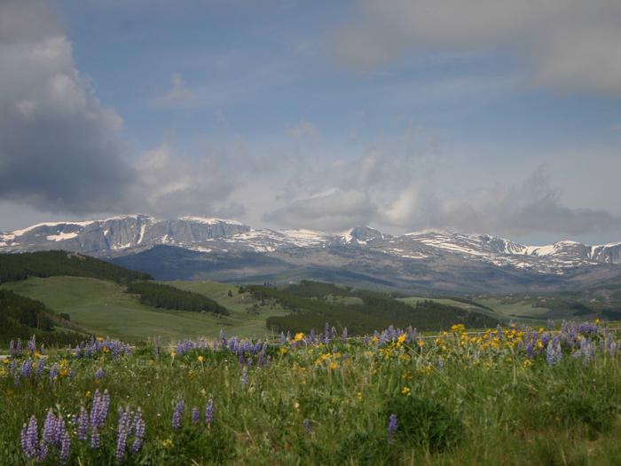
Bighorn National Forest
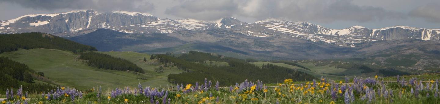
Rising between the Powder River and Big Horn Basins, this scenic country offers year round recreation connecting visitors to a land rich in history and solitude. For centuries, the mountain landscape has provided renewal for Native Americans, homesteaders and modern day explorers creating a human connection with this spectacular place. Today there is a bond with "the mountain" for local residents, which contributes to the quality of life in local communities. Viewing scenery and wildlife, while incorporating a rich history, connects locals and travelers to this accessible landscape.
To view recreation features on the map below . . .
Click on the Forest Service shield for the area you want to visit: Buffalo, Greybull, or Sheridan. Then click on "Go to the Buffalo, WY page," for example, to see a map showing the locations of campgrounds, trailheads, and other sites in that ranger district.
RecAreaDirections
Open with Google Map
Misc
| Stay Limit | |
| Reservable | false |
| Keywords | |
| Map Link | |
| Contact Phone | |
| Contact Email |
Permits info
Facilities
SHEEP MOUNTAIN FIRE LOOKOUT Campground
List of CampsitesOverview
Perched atop a forested mountain, the historic Sheep Mountain Fire Lookout offers a unique recreation experience -- one of few fire lookouts in the region available for overnight rental. Constructed in 1950 by the Civilian Conservation Corps (CCC) atop Sheep Mountain at an elevation of 9,600 feet, the lookout was historically occupied as a fire lookout until the early 1970s. The lookout is available for rental from June 15 through October 20; however, access to the facility may be limited depending on snow accumulation. Guests are advised to call ahead to confirm access to the facility. Limited amenities are provided; please be prepared to pack in supplies and gear for a comfortable stay. Visitors are advised that this facility has always been a popular destination for recreational visitors to come and enjoy the views and historical nature of the area, therefore, solitude from other forest users may not be an option at this facility.Recreation
The area surrounding the lookout offers endless opportunities for ATV riding, mountain biking, hiking, fishing or hunting. The lookout is also ideal for visitors who simply want to relax and enjoy stargazing, wildlife viewing, mountain streams and abundant wildflowers.Facilities
This facility is primitive in nature. While a single vault toilet and one set of bunk beds are available, there is no running water, indoor plumbing or electricity. Basically, what is available are four sturdy walls, sound roof, no neighbors and commanding views from the lower quadrant of the Bighorn Mountains all the way out to South Dakota's forests. It is recommended that guests bring all their water and accommodations needed for overnight camping. This is a "pack-it-in, pack-it-out" facility; guests will need to carry out all trash and clean the facility prior to leaving.Natural Features
Besides offering the unique experience of staying in a historical fire lookout, Sheep Mountain Lookout will provide visitors with panoramic views from the mountain peaks in the Cloud Peak Wilderness all the way out through the Powder River Basin. On a clear day, visitors can see to Devils Tower National Monument. Due to the high elevation, guests should be prepared for high altitude conditions including high winds. Summertime temperatures average 70 degrees, but can drop as low as 30 degrees at night or during thunderstorms.Nearby Attractions
The town of Buffalo, Wyoming, is located within a 45 minute drive for amenities such as grocery stores, swimming pool, historic downtown and a museum.CIRCLE PARK CAMPGROUND Campground
List of CampsitesOverview
Circle Park Campground is located about 15 miles west of Buffalo, Wyoming, on the east side of scenic Cloud Peak Skyway, near the Cloud Peak Wilderness Area. Part of the Bighorn National Forest, the area offers a wide variety of activities, including hiking, fishing, scenic driving and a number of historic sites. The administering organization is Gallatin Canyon Campgrounds; e-mail: [email protected]Recreation
Scenic off-road driving is available on nearby Elgin Park, Pole Creek and Crazy Woman Canyon Roads. Hiking and mountain biking are allowed on these roads as well. High Park Lookout, a short hike east of Meadowlark Lake, is an old fire lookout offering panoramic views of the area. There is fishing at nearby streams and lakes including Tie Hack Reservoir, a non-motorized lake, and Meadowlark Lake for rainbow, cutthroat, brown, and brook trout. Many additional hiking trails are available in the Cloud Peak Wilderness.Facilities
The campground offers several single-family sites each equipped with a picnic table and campfire ring with grill. Vault toilets, drinking water from a hand pump, fire wood sales, and trash collection are provided.The nearest dump station is 27 miles away on Powder River Pass.
Natural Features
The campground sits at the edge of a meadow tucked in a dense forest of lodgepole pine and aspen with widely spaced sites. Circle Park Trailhead leading into the Cloud Peak Wilderness is nearby.Nearby Attractions
The adjacent Cloud Peak Skyway provides for scenic driving. Many additional hiking trails are available in the Cloud Peak Wilderness. Fishing is popular in the campground and nearby streams and Tie Hack Reservoir.Charges & Cancellations
Refunds: Refund requests made through www.recreation.gov will be charged a $10 processing fee. This cancellation processing fee is retained by the reservation service contractor along with the non-refundable reservation fee. All requests for the return of the non-refundable reservation fee and the cancellation processing fee will be declined by the campground concessionaire as they did not receive these fees (these are the fees retained by the reservation contractor, a different entity).
BURGESS JUNCTION VISITOR CENTER Campground
List of CampsitesOverview
This site is not currently accepting reservations.Recreation
Facilities
Natural Features
Nearby Attractions
MIDDLE FORK Campground
List of CampsitesOverview
Middle Fork Campground is located 14 miles west of Buffalo, Wyoming, adjacent to the Cloud Peak Skyway (scenic byway), near the Cloud Peak Wilderness Area. The Bighorn National Forest offers a wide variety of activities, including hiking, fishing, scenic driving and a number of historic sites. The administering organization is Gallatin Canyon Campgrounds; e-mail: [email protected]Recreation
Nearby Tie Hack Reservoir is a non-motorized lake offering a great location for canoeing and fishing. Anglers cast for rainbow, cutthroat, brown and brook trout.The Circle Park Trailhead is 3.5 miles from the campground. This beautiful trail accesses numerous alpine lakes and two 12,000' peaks within the Cloud Peak Wilderness. Many additional hiking trails are available in the area.
Scenic off-road driving is available on nearby Elgin Park, Pole Creek and Crazy Woman Canyon Roads. Hiking and mountain biking are allowed on these roads as well. Mountain bikes are allowed on the trails up to the Cloud Peak Wilderness boundary.
Facilities
The campground offers single-family sites, each equipped with a picnic table and campfire ring with grill. Vault toilets, drinking water and trash collection are provided.Natural Features
The campground sits on the banks of the Middle Fork of Clear Creek, within pine and aspen forests. Tie Hack Reservoir and numerous additional creeks are found nearby.Nearby Attractions
South Fork Lodge is located within 10 miles and offers dining option, lodging, guided horseback riding, a fishing pond, and a small store with fishing and camping supplies.A dump station is available 18 miles away at Powder River Pass.
Charges & Cancellations
Refunds: Refund requests made through www.recreation.gov will be charged a $10 processing fee. This cancellation processing fee is retained by the reservation service contractor along with the non-refundable reservation fee. All requests for the return of the non-refundable reservation fee and the cancellation processing fee will be declined by the campground concessionaire as they did not receive these fees (these are the fees retained by the reservation contractor, a different entity).
SOUTH FORK (WYOMING) Campground
List of CampsitesOverview
South Fork Campground is located 15 miles west of Buffalo, Wyoming on the east side of scenic Cloud Peak Skyway, near the Cloud Peak Wilderness Area. The surrounding Bighorn National Forest offers a wide variety of activities, including hiking, fishing, scenic driving and a number of historic sites. The administering organization is Gallatin Canyon Campgrounds; e-mail: [email protected]Recreation
Tie Hack Reservoir is nearby, offering a great location for canoeing and fishing. Anglers will find rainbow, cutthroat, brown and brook trout in the lake.The Circle Park Trailhead is 3 miles from the campground. This beautiful trail accesses numerous alpine lakes and two 12,000' peaks within the Cloud Peak Wilderness. Many additional hiking trails are available in the area.
Scenic off-road driving is available at nearby Elgin Park, Pole Creek and Crazy Woman Canyon Roads. Hiking and mountain biking are allowed on these roads as well.
Facilities
This fully accessible campground offers single-family sites each equipped with a picnic table and campfire ring with grill. Vault toilets, drinking water and trash collection are provided.Natural Features
The campground is situated on the banks of South Fork Clear Creek at an elevation of 7,800 feet. A dense forest of lodgepole pine covers the campground.Nearby Attractions
South Fork Lodge is located across the highway from the campground, offering dining options, lodging, guided horseback riding, a fishing pond and a small store with fishing and camping supplies.Charges & Cancellations
Refunds: Refund requests made through www.recreation.gov will be charged a $10 processing fee. This cancellation processing fee is retained by the reservation service contractor along with the non-refundable reservation fee. All requests for the return of the non-refundable reservation fee and the cancellation processing fee will be declined by the campground concessionaire as they did not receive these fees (these are the fees retained by the reservation contractor, a different entity).
Ranger Creek Recreation Area Campground
List of CampsitesOverview
Ranger Creek Group Campground is located just off the Bighorn Scenic Byway (U.S. Highway 14) at an elevation of 7,500 feet. The Bighorn National Forest offers a wide variety of activities, including hiking, fishing, scenic driving and a number of historic sites. The administering organization is Gallatin Canyon Campgrounds; e-mail: [email protected]Recreation
Scenic off-road driving is available on Battle Creek Road to Medicine Lodge Lake, Ranger Creek Road to Shell Reservoir, Hunt Mountain Road and the Burgess Overlook Jeep trail.Diverse hiking opportunities vary from loop trails to treks along creeks and over mountain peaks including access to the Cloud Peak Wilderness. The Adelaide Trail, for hiking and horseback riding is nearby, providing access to Shell Creek and the Shell Creek Trail.
Many creeks, lakes and ponds dot the region, offering some of the best trout fly-fishing in the state.
Facilities
The campground offers one large group site that can accommodate up to 150 people for overnight camping or day-use picnicking.A shelter covers several picnic and serving tables, and a campfire ring and grill are on-site. Accessible vault toilets, drinking water and trash collection are provided.
The nearest dump station is 20 miles away at Burgess Junction.
Natural Features
The campground is situated on the banks of Ranger Creek in the Bighorn Mountains, where craggy granite peaks rise over 13,000 feet above sea level. The area is forested with a mix of pine and aspen trees. An abundance of wildlife lives in the area.Nearby Attractions
The Shell Falls Visitor Center, at the overlook of Shell Falls, is about 8 miles west. Burgess Junction Visitor Center is 20 miles north. Both centers offer interpretive trails, scenic views and educational displays about natural features like flora and fauna, and area history.Elk View Inn and other nearby lodges provide guided horseback riding and fishing adventures, off-road vehicle rentals and fishing supplies, as well as dining options, showers and general stores.
The Red Gulch Dinosaur Tracksite, near the town of Shell, is the largest of its kind in the state and one of only a few in the world from the Middle Jurassic Period. The tracks found here are approximately 167 million years old.
Charges & Cancellations
Refunds: Refund requests made through www.recreation.gov will be charged a $10 processing fee. This cancellation processing fee is retained by the reservation service contractor along with the non-refundable reservation fee. All requests for the return of the non-refundable reservation fee and the cancellation processing fee will be declined by the campground concessionaire as they did not receive these fees (these are the fees retained by the reservation contractor, a different entity).
LAKEVIEW BIGHORN Campground
List of CampsitesOverview
Lakeview Campground is located on Meadowlark Lake about 50 miles east of Worland, Wyoming on the west side of scenic Cloud Peak Skyway, near the Cloud Peak Wilderness Area. The Bighorn National Forest offers a wide variety of activities, including hiking, fishing, scenic driving and a number of historic sites. The administering organization is Gallatin Canyon Campgrounds; e-mail: [email protected]Recreation
Meadowlark Lake covers 325 acres and is open to boating at a wake-less speed, making it a perfect location for canoeing and fishing. Anglers will find rainbow, cutthroat, brown and brook trout in the cool waters of the lake.Off-road vehicle trails, scenic jeep roads, hiking and additional fishing streams are available in the surrounding area. Diverse hikes vary from loop trails to treks along creeks and over mountain peaks; many trails access the Cloud Peak Wilderness.
Facilities
The campground offers single-family sites each equipped with a picnic table and campfire ring with grill. Accessible vault toilets, drinking water and trash collection are provided.The nearest dump station is 12 miles away on Powder River Pass.
Natural Features
The campground overlooks scenic Meadowlark Lake, which can be viewed from several sites. A forest of lodgepole pine and Douglas fir trees covers the campground. Many additional lakes and streams are found in the surrounding area.Nearby Attractions
The High Park Lookout is located just east of Meadowlark Lake. This old fire lookout was built by the CCC decades ago and is no longer active. A short hike leads to the lookout, where hikers are awarded panoramic views of the surrounding area.West Tensleep Lake is about 10 miles north of Meadowlark Lake and is open to non-motorized craft only. The popular West Tensleep Lake Trail begins here and leads into the Cloud Peak Wilderness.
Deer Haven Lodge and Meadowlark Lodge are nearby, offering dining options, lodging, guided horseback riding and fishing and camping supplies.
Charges & Cancellations
Refunds: Refund requests made through www.recreation.gov will be charged a $10 processing fee. This cancellation processing fee is retained by the reservation service contractor along with the non-refundable reservation fee. All requests for the return of the non-refundable reservation fee and the cancellation processing fee will be declined by the campground concessionaire as they did not receive these fees (these are the fees retained by the reservation contractor, a different entity).
SITTING BULL Campground
List of CampsitesOverview
Sitting Bull Campground is located 51 miles east of Worland, Wyoming on the west side of scenic Cloud Peak Skyway, near the Cloud Peak Wilderness Area. The Bighorn National Forest offers a wide variety of activities, including hiking, fishing, scenic driving and a number of historic sites. The administering organization is Gallatin Canyon Campgrounds; e-mail: [email protected]Recreation
Nearby Meadowlark Lake covers 325 acres and is open to boating at a wake-less speed, making it a perfect location for canoeing and fishing. Anglers will find rainbow, cutthroat, brown and brook trout in the cool waters of the lake.Off-road vehicle trails, scenic jeep roads, hiking and additional fishing streams are available in the surrounding area. Diverse hikes vary from loop trails to treks along creeks and over mountain peaks; many trails access the Cloud Peak Wilderness.
Facilities
The campground offers several single-family sites each equipped with a picnic table and campfire ring with grill. Site 006 meets established accessibility standards. Accessible vault toilets, drinking water and trash collection are also provided.Natural Features
Sitting Bull is situated on the edge of a forest of lodgepole pine, adjacent to a beautiful mountain meadow, a prime location for wildlife viewing. Most sites afford expansive views of the surrounding Bighorn Mountains.Nearby Attractions
The High Park Lookout is located just east of Meadowlark Lake. This old fire lookout was built by the CCC decades ago and is no longer active. A short hike leads to the lookout, where hikers are awarded panoramic views of the surrounding area.West Tensleep Lake is about 10 miles north of the campground and is open to non-motorized craft only. The popular West Tensleep Lake Trail begins here and leads into the Cloud Peak Wilderness.
Deer Haven Lodge and Meadowlark Lodge are nearby, offering dining options, lodging, guided horseback riding and fishing and camping supplies.
Charges & Cancellations
Refunds: Refund requests made through www.recreation.gov will be charged a $10 processing fee. This cancellation processing fee is retained by the reservation service contractor along with the non-refundable reservation fee. All requests for the return of the non-refundable reservation fee and the cancellation processing fee will be declined by the campground concessionaire as they did not receive these fees (these are the fees retained by the reservation contractor, a different entity).
WEST TENSLEEP LAKE Campground
List of CampsitesOverview
West Tensleep Lake Campground is located on West Tensleep Lake on the west side of scenic Cloud Peak Skyway, near the Cloud Peak Wilderness Area. The Bighorn National Forest offers a wide variety of activities, including hiking, fishing, scenic driving and a number of historic sites. The administering organization is Gallatin Canyon Campgrounds; e-mail: [email protected]Recreation
West Tensleep Lake covers 125 acres and is open to non-motorized watercraft only, making it a perfect location for canoeing and fishing. Anglers will find rainbow, brown and brook trout in the cool waters of the lake.The popular West Tensleep Lake Trail begins just outside the campground. The trail leads into the Cloud Peak Wilderness, passing Lake Helen, Lake Marion and Misty Moon Lake before climbing to the summit of the 13,167 foot Cloud Peak, the highest peak in the Bighorn Range.
Off-road vehicle trails, scenic jeep roads, hiking and horseback riding trails and many fishing streams are available in the surrounding area.
Facilities
The campground offers single-family sites each equipped with a picnic table and campfire ring with grill. Accessible vault toilets, drinking water and trash collection are provided.The nearest dump station is 17 miles away on Powder River Pass
Natural Features
The campground is situated on the southern shore of scenic West Tensleep Lake, in an area full of alpine lakes and creeks. A forest of lodgepole pine, Douglas fir and spruce trees covers the area.Nearby Attractions
Meadowlark Lake is within a few miles of the campground. This small lake allows motorized craft at a no-wake speed.The High Park Lookout is located just east of Meadowlark Lake. This old fire lookout was built by the CCC decades ago and is no longer active. A short hike leads to the lookout, where hikers are awarded panoramic views of the surrounding area.
Deer Haven Lodge and Meadowlark Lodge are nearby, offering dining, lodging, guided horseback riding and fishing and camping supplies.
Charges & Cancellations
Refunds: Refund requests made through www.recreation.gov will be charged a $10 processing fee. This cancellation processing fee is retained by the reservation service contractor along with the non-refundable reservation fee. All requests for the return of the non-refundable reservation fee and the cancellation processing fee will be declined by the campground concessionaire as they did not receive these fees (these are the fees retained by the reservation contractor, a different entity).
WILLOW PARK Campground
List of CampsitesOverview
Willow Park is located about 50 miles east of Worland, Wyoming on the west side of scenic Cloud Peak Skyway, near the Cloud Peak Wilderness Area. The Bighorn National Forest offers a wide variety of activities, including hiking, fishing, scenic driving and a number of historic sites. The administering organization is Gallatin Canyon Campgrounds; e-mail: [email protected]Recreation
Off-road vehicle trails, scenic jeep roads, hiking and additional fishing streams are available in the surrounding area. Diverse hikes vary from loop trails to treks along creeks and over mountain peaks; many trails access the Cloud Peak Wilderness.Meadowlark Lake is within a couple miles of the campground. This small lake allows motorized craft at a no-wake speed. West Tensleep Lake, a few miles north of the campground, is open to non-motorized craft only.
Facilities
The campground offers one group site that can accommodate up to 150 people for day-use picnicking and up to 60 people for overnight camping. The site is equipped with several picnic and serving tables, grills and a campfire circle with benches. Accessible vault toilets, drinking water and trash collection are provided.Natural Features
The campground is situated in an open meadow surrounded by a forest of lodgepole pine. Many lakes and streams are found throughout the Bighorn Mountains.Nearby Attractions
The James T. Saban Lookout is located just east of Meadowlark Lake. This old fire lookout was built by the CCC decades ago and is no longer active. A short hike leads to the lookout, where hikers are awarded panoramic views of the surrounding area.Deer Haven Lodge and Meadowlark Lodge are nearby, offering dining options, lodging, guided horseback riding and fishing and camping supplies.
Charges & Cancellations
Refunds: Refund requests made through www.recreation.gov will be charged a $10 processing fee. This cancellation processing fee is retained by the reservation service contractor along with the non-refundable reservation fee. All requests for the return of the non-refundable reservation fee and the cancellation processing fee will be declined by the campground concessionaire as they did not receive these fees (these are the fees retained by the reservation contractor, a different entity).
Hunter Campground Campground
List of CampsitesOverview
Hunter Trailhead is a campground constructed with the equestrian camper in mind, but available for all users. The campground is located in Johnson Country, Wyoming, just two miles off the Cloud Peak Scenic Byway on Highway 16. The winding drive to the campground travels two miles west of U.S. Highway 16 on Forest Road 19 and is an easily accessible gravel road offering views of wildlife, mountain streams, and abundant wildflowers.Recreation
Rising between the Powder River and Big Horn Basins, this scenic country offers year round recreation connecting visitors to a land rich in history and solitude. For centuries, the mountain landscape has provided renewal for Native Americans, homesteaders and modern day explorers creating a human connection with this spectacular place.The Hunter Trailhead provides numerous hiking and horse friendly trails to access front-country, the Cloud Peak Wilderness as well as the Rock Creek Recommended Wilderness Area. The surrounding Bighorn National Forest offers a wide variety of activities, including hiking, fishing, scenic driving, wildlife and a number of historic sites.
Facilities
The non-fee portion of the site provides access to the trailhead and includes parking for 15 single vehicles and 18 vehicles with trailers, and a separate area for Outfitter/Guide parking. Of the 11 sites, nine are reservable, one is used by the host during July/August and the remaining two are available on a first-come, first-serve basis.Each campsite has a 20 by 20 foot hardened use pad with a picnic table, utility table, fire ring and an individual livestock corral. The spur for each campsite is 65 feet long by 20 feet wide. Potable water is available at the facility through a pressurized solar water system. The entire facility is ADA (Americans with Disabilities) accessible including the ramp for horse mounting.
Natural Features
No region in Wyoming is provided with a more diverse landscape - from lush grasslands to alpine meadows, from crystal-clear lakes to glacially-carved valleys, from rolling hills to sheer mountain walls. The campground is situated high in the Bighorn Mountains in northern Wyoming, at an elevation of 7,800 feet, so be prepared for all types of weather. A dense forest of lodgepole pine is the dominant vegetative cover.Nearby Attractions
Tie Hack Reservoir is a 15-minute drive southeast of the campground. The scenic lake offers a great location for canoeing and fishing. Anglers there cast for rainbow, cutthroat, brown and brook trout.PRUNE CREEK Campground
List of CampsitesOverview
Prune Creek Campground is located along the Bighorn Scenic Byway (U.S. Highway 14) near the Burgess Junction at an elevation of 7,700 feet. The Bighorn National Forest offers a wide variety of activities, including hiking, fishing, scenic driving and a number of historic sites. The administering organization is Gallatin Canyon Campgrounds; e-mail: [email protected]Recreation
Off-road vehicle trails, scenic jeep roads, hiking, fishing and canoeing are available in the surrounding area. Diverse hikes vary from loop trails to treks along creeks and over mountain peaks; many trails access the Cloud Peak Wilderness.Nearby Sibley Lake is open to non-motorized craft and offers an accessible fishing dock on the shoreline. Anglers fish for rainbow, brown and brook trout.
Facilities
The campground offers several single-family sites each equipped with a picnic table and campfire ring with grill. Accessible vault toilets, drinking water and trash collection are provided.Natural Features
The campground is situated on the banks of the South Fork Tongue River in the Bighorn Mountains, where craggy granite peaks rise over 13,000 feet above sea level. A forest of lodgepole pines covers the area, creating excellent wildlife habitat.Nearby Attractions
Shell Falls Visitor Center, at the overlook of Shell Falls, is about 23 miles southwest. This center offers interpretive trails, scenic views, and educational displays about natural features such as flora and fauna and area history.The Medicine Wheel National Historic Landmark is about 28 miles from the campground. This unique geoglyph signifies all creation, all races of people, birds, fish, animals, trees and stones. According to tribal beliefs, the circular shape of the wheel represents the earth, sun, moon, the cycles of life, seasons and day to night.
Arrowhead Lodge, Bear Lodge and Elk View Inn are nearby, offering off-road vehicle rentals and fishing supplies, as well as dining options and general stores.
Charges & Cancellations
Refunds: Refund requests made through www.recreation.gov will be charged a $10 processing fee. This cancellation processing fee is retained by the reservation service contractor along with the non-refundable reservation fee. All requests for the return of the non-refundable reservation fee and the cancellation processing fee will be declined by the campground concessionaire as they did not receive these fees (these are the fees retained by the reservation contractor, a different entity).
BALD MOUNTAIN CAMPGROUND Campground
List of CampsitesOverview
Bald Mountain Campground is located along the Medicine Wheel Passage Scenic Byway (U.S. Highway 14A), 33 miles east of Lovell, Wyoming. The Medicine Wheel National Historic Landmark is nearby. Visitors enjoy the area for its scenic natural beauty and recreational opportunities. The administering organization is Gallatin Canyon Campgrounds; e-mail: [email protected]Recreation
From the area's historic mining sites to the ancient Native American Medicine Wheel, to hiking through open meadows and along the cliffs on the west rim of the mountains, the Bighorn National Forest offers many recreational opportunities.Jaws Trailhead is near the campground, offering access to Bucking Mule Falls Trail and Porcupine Creek. Scenic off-road driving is available on Hunt Mountain Road or Burgess Overlook jeep trail.
Facilities
The campground offers single-family sites, each with a picnic table and campfire ring with grill. Accessible vault toilets, drinking water and trash collection are provided.The nearest dump station is 25 miles east at Burgess Junction
Natural Features
Bald Mountain is part of the Bighorn Range in northern Wyoming. A forest of pine and aspen covers the campground, which sits near top of the mountain at an elevation of 9,200 feet. Small creeks wind through the campground and temperatures can drop significantly once the sun goes down.Nearby Attractions
The Medicine Wheel National Historic Landmark is 4 miles from the campground. This unique geoglyph signifies all creation, all races of people, birds, fish, animals, trees and stones. According to tribal beliefs, the circular shape of the wheel represents the earth, sun, moon, cycles of life, seasons and day to night.High Country Lodge is nearby, offering guided horseback riding and backcountry pack trips, off-road vehicle rentals and guided fishing trips.
Charges & Cancellations
Refunds: Refund requests made through www.recreation.gov will be charged a $10 processing fee. This cancellation processing fee is retained by the reservation service contractor along with the non-refundable reservation fee. All requests for the return of the non-refundable reservation fee and the cancellation processing fee will be declined by the campground concessionaire as they did not receive these fees (these are the fees retained by the reservation contractor, a different entity).
BOULDER PARK CAMPGROUND Campground
List of CampsitesOverview
Boulder Park Campground is located about 50 miles east of Worland, Wyoming on the west side of scenic Cloud Peak Skyway, near the Cloud Peak Wilderness area. The Bighorn National Forest offers a wide variety of activities, including hiking, fishing, scenic driving and a number of historic sites. The administering organization is Gallatin Canyon Campgrounds; e-mail: [email protected]Recreation
Off-road vehicle trails, scenic jeep roads, hiking and additional fishing streams are available in the surrounding area. Diverse hikes vary from loop trails to treks along creeks and over mountain peaks; many trails access the Cloud Peak Wilderness.Meadowlark Lake is within a couple miles of the campground. This small lake allows motorized craft at a wake-less speed. West Tensleep Lake, a few miles north of the campground, is open to non-motorized craft only. Both lakes are great locations for canoeing and fishing.
Facilities
The campground offers several single-family sites each equipped with a picnic table and campfire ring with grill. Accessible vault toilets, drinking water and trash collection are provided.The nearest dump station is 15 miles away at Powder River Pass.
Natural Features
The campground sits on the banks of West Tensleep Creek in an open meadow surrounded by a forest of lodgepole pine. Many lakes and streams are found in the surrounding Bighorn Mountains.Nearby Attractions
The High Park Lookout is located just east of Meadowlark Lake. This old fire lookout was built by the CCC decades ago and is no longer active. A short hike leads to the lookout, where hikers are awarded panoramic views of the surrounding area.Deer Haven Lodge and Meadowlark Lodge are nearby, offering dining options, lodging, guided horseback riding and fishing and camping supplies.
Charges & Cancellations
Refunds: Refund requests made through www.recreation.gov will be charged a $10 processing fee. This cancellation processing fee is retained by the reservation service contractor along with the non-refundable reservation fee. All requests for the return of the non-refundable reservation fee and the cancellation processing fee will be declined by the campground concessionaire as they did not receive these fees (these are the fees retained by the reservation contractor, a different entity).
HETTINGER GROUP AREA Campground
List of CampsitesOverview
Hettinger Group Campground is located 14 miles west of Buffalo, Wyoming on the east side of scenic Cloud Peak Skyway, near the Cloud Peak Wilderness Area. The surrounding Bighorn National Forest offers a wide variety of activities, including hiking, fishing, scenic driving and a number of historic sites. The administering organization is Gallatin Canyon Campgrounds; e-mail: [email protected]Recreation
Tie Hack Reservoir is a short drive away, offering a great location for canoeing and fishing. Anglers cast for rainbow, cutthroat, brown and brook trout. A short trail leads from the campground to the lake.The Circle Park Trailhead is 3 miles from the campground. This beautiful trail accesses numerous alpine lakes and two 12,000' peaks within the Cloud Peak Wilderness. Many additional hiking trails are available in the area.
Scenic off-road driving is available on nearby Elgin Park, Pole Creek and Crazy Woman Canyon Roads. Hiking and mountain biking are allowed on these roads as well.
Facilities
The campground offers one group site that can accommodate up to 150 people, and can be used for overnight camping or day-use picnicking. The site is equipped with picnic tables, grills and a campfire circle. Vault toilets, drinking water and trash collection are also provided.The nearest dump station is 18 miles away on Powder River Pass.
Natural Features
The campground is situated in a small meadow within a dense forest of lodgepole pine. Tie Hack Reservoir and several creeks are nearby.Nearby Attractions
South Fork Lodge is nearby, offering dining options, lodging, guided horseback riding, a fishing pond and a small store with fishing and camping supplies.Charges & Cancellations
Refunds: Refund requests made through www.recreation.gov will be charged a $10 processing fee. This cancellation processing fee is retained by the reservation service contractor along with the non-refundable reservation fee. All requests for the return of the non-refundable reservation fee and the cancellation processing fee will be declined by the campground concessionaire as they did not receive these fees (these are the fees retained by the reservation contractor, a different entity).
PINE ISLAND GROUP AREA Campground
List of CampsitesOverview
Pine Island Group Area is located along the Bighorn Scenic Byway (U.S. Highway 14) near the Burgess Junction at an elevation of 8,400 feet. The Bighorn National Forest offers a wide variety of activities, including hiking, fishing, scenic driving and a number of historic sites. The administering organization is Gallatin Canyon Campgrounds; e-mail: [email protected]Recreation
Off-road vehicle trails, scenic jeep roads, hiking, fishing and canoeing are available in the surrounding area. Diverse hikes vary from loop trails to treks along creeks and over mountain peaks; many trails access the Cloud Peak Wilderness.Nearby Sibley Lake is open to non-motorized craft and offers an accessible fishing dock on the shoreline. Anglers fish for rainbow, brown and brook trout.
Facilities
The campground offers one group site for overnight camping or day-use picnicking. It can accommodate up to 150 people. A three-sided picnic shelter with 30-amp electric plugs is on-site.Picnic and serving tables, a campfire circle and grill are provided, as are accessible vault toilets, drinking water and trash collection.
Natural Features
The campground is situated on the banks of the South Fork Tongue River in the Bighorn Mountains, where craggy granite peaks rise over 13,000 feet above sea level. A forest of lodgepole pine covers the area, creating excellent wildlife habitat. Englemann spruce and Douglas fir dot the landscape.Nearby Attractions
Shell Falls Visitor Center, at the overlook of Shell Falls, is about 22 miles southwest. This center offers interpretive trails, scenic views, and educational displays about natural features such as flora and fauna and area history.The Medicine Wheel National Historic Landmark is about 27 miles from the campground. This unique geoglyph signifies all creation and according to tribal beliefs, the circular shape of the wheel represents the earth, sun, moon, the cycles of life, seasons and day to night.
Arrowhead Lodge, Bear Lodge and Elk View Inn are nearby, offering off-road vehicle rentals and fishing supplies, as well as dining options and general stores.
Charges & Cancellations
Refunds: Refund requests made through www.recreation.gov will be charged a $10 processing fee. This cancellation processing fee is retained by the reservation service contractor along with the non-refundable reservation fee. All requests for the return of the non-refundable reservation fee and the cancellation processing fee will be declined by the campground concessionaire as they did not receive these fees (these are the fees retained by the reservation contractor, a different entity).
TIE HACK Campground
List of CampsitesOverview
Tie Hack Campground is located close to Tie Hack Reservoir, just 15 miles west of Buffalo, Wyoming on the east side of scenic Cloud Peak Skyway, near the Cloud Peak Wilderness Area. The Bighorn National Forest offers a wide variety of activities, including hiking, fishing, scenic driving and a number of historic sites. The administering organization is Gallatin Canyon Campgrounds; e-mail: [email protected]Recreation
Tie Hack Reservoir offers a great location for canoeing and fishing. Anglers cast for rainbow, cutthroat, brown and brook trout. A short trail leads from the campground to the lake.The Circle Park Trailhead is 3 miles from the campground. This beautiful trail accesses numerous alpine lakes and two 12,000' peaks within the Cloud Peak Wilderness. Many additional hiking trails are available in the area.
Scenic off-road driving is available on nearby Elgin Park, Pole Creek and Crazy Woman Canyon Roads. Hiking and mountain biking are allowed on these roads as well.
Facilities
The campground offers single-family sites, which can accommodate a maximum of 8 people at one time. If your party includes more guests, there is group camping available at nearby Willow Park, Hettinger, Ranger Creek Recreation Area and Pine Island.Two sites at the campground meet accessibility standards and all sites are equipped with a picnic table and campfire ring with grill. Accessible vault toilets, drinking water and trash collection are also provided.
Natural Features
The campground is situated near the shore of scenic Tie Hack Reservoir at an elevation of 7,900 feet. A dense forest of lodgepole pine covers the campground. Rock outcroppings are found inside the campground and along the shoreline.Nearby Attractions
South Fork Lodge is nearby, offering dining options, lodging, guided horseback riding, a fishing pond and a small store with fishing and camping supplies.Charges & Cancellations
Refunds: Refund requests made through www.recreation.gov will be charged a $10 processing fee. This cancellation processing fee is retained by the reservation service contractor along with the non-refundable reservation fee. All requests for the return of the non-refundable reservation fee and the cancellation processing fee will be declined by the campground concessionaire as they did not receive these fees (these are the fees retained by the reservation contractor, a different entity).
LOST CABIN CAMPGROUND Campground
List of CampsitesOverview
Lost Cabin Campground is located 29 miles west of Buffalo, Wyoming on the east side of scenic Cloud Peak Skyway, near the Cloud Peak Wilderness Area. The Bighorn National Forest offers a wide variety of activities, including hiking, fishing, scenic driving and a number of historic sites. The administering organization is Gallatin Canyon Campgrounds; e-mail: [email protected]Recreation
Scenic off-road driving is available on nearby Elgin Park, Pole Creek and Crazy Woman Canyon Roads. Hiking and mountain biking are allowed on these roads as well.Many additional hiking trails are available in the Cloud Peak Wilderness. A short trail leads from the campground to a scenic creek below.
Facilities
The campground offers several single-family sites each equipped with a picnic table and campfire ring with grill. Accessible vault toilets, drinking water and trash collection are provided.The nearest dump station is 12 miles away on Powder River Pass.
Natural Features
The campground is situated on a hillside above Highway 16. A dense forest of lodgepole pine covers the area and North Fork Creek flows nearby.Nearby Attractions
Meadowlark Lake is 20 minutes west of the campground, and Tie Hack Reservoir is 20 minutes north. Both lakes are great locations for canoeing and fishing.The High Park Lookout is located just east of Meadowlark Lake. This old fire lookout was built by the CCC decades ago and is no longer active. A short hike leads to the lookout, where hikers are awarded panoramic views of the surrounding area.
South Fork Lodge is nearby, offering dining options, lodging, guided horseback riding and fishing and camping supplies.
Charges & Cancellations
Refunds: Refund requests made through www.recreation.gov will be charged a $10 processing fee. This cancellation processing fee is retained by the reservation service contractor along with the non-refundable reservation fee. All requests for the return of the non-refundable reservation fee and the cancellation processing fee will be declined by the campground concessionaire as they did not receive these fees (these are the fees retained by the reservation contractor, a different entity).
SIBLEY LAKE Campground
List of CampsitesOverview
Sibley Lake Campground is located at Sibley Lake along the Bighorn Scenic Byway (U.S. Highway 14) near the Burgess Junction at an elevation of 7,900 feet. The Bighorn National Forest offers a wide variety of activities, including hiking, fishing, scenic driving and a number of historic sites. The administering organization is Gallatin Canyon Campgrounds; e-mail: [email protected]Recreation
Sibley Lake is open to non-motorized craft and offers an accessible fishing dock on the shoreline. Anglers fish for rainbow, brown and brook trout.Off-road vehicle trails, scenic jeep roads, hiking and additional fishing streams are available in the surrounding area. Diverse hikes vary from loop trails to treks along creeks and over mountain peaks; many trails access the Cloud Peak Wilderness.
Facilities
The campground offers several single-family sites each equipped with a picnic table and campfire ring with grill. Accessible vault toilets, drinking water and trash collection are provided.Natural Features
The campground is situated near Sibley Lake and Prune Creek in the Bighorn Mountains, where craggy granite peaks rise over 13,000 feet above sea level. A forest of lodgepole pine covers the area, creating excellent wildlife habitat.Nearby Attractions
Shell Falls Visitor Center, at the overlook of Shell Falls, is about 25 miles southwest. This center offers interpretive trails, scenic views, and educational displays about natural features such as flora and fauna and area history.Charges & Cancellations
Refunds: Refund requests made through www.recreation.gov will be charged a $10 processing fee. This cancellation processing fee is retained by the reservation service contractor along with the non-refundable reservation fee. All requests for the return of the non-refundable reservation fee and the cancellation processing fee will be declined by the campground concessionaire as they did not receive these fees (these are the fees retained by the reservation contractor, a different entity).
TIE FLUME Campground
List of CampsitesOverview
Tie Flume Campground is located just off the Bighorn Scenic Byway (U.S. Highway 14) near the Burgess Overlook and Woodrock areas at an elevation of 8,400 feet. The Bighorn National Forest, where the campground is located, offers a wide variety of activities, including hiking, fishing, scenic driving and a number of historic sites. The administering organization is Gallatin Canyon Campgrounds; e-mail: [email protected]Recreation
Off-road vehicle trails, scenic jeep roads, hiking, fishing and canoeing are available in the surrounding area. Diverse hikes vary from loop trails to treks along creeks and over mountain peaks; many trails access the Cloud Peak Wilderness.Nearby Sibley Lake is open to non-motorized craft and offers an accessible fishing dock on the shoreline. Anglers fish for rainbow, brown and brook trout.
Facilities
The campground offers several single-family sites each equipped with a picnic table and campfire ring with grill. Accessible vault toilets, drinking water and trash collection are provided.Natural Features
The campground is situated on the banks of the South Tongue River in the Bighorn Mountains, where craggy granite peaks rise over 13,000 feet above sea level. A forest of lodgepole pine covers the area, creating excellent wildlife habitat.Nearby Attractions
Decades ago, many trees in the Tie Flume area were cut for railroad ties. Remnants of the old splash dams and tie flumes are found on the river around the campground.Shell Falls Visitor Center, at the overlook of Shell Falls, is about 18 miles southwest. This center offers interpretive trails, scenic views, and educational displays about natural features such as flora and fauna and area history.
Bear Lodge, Elk View Inn and other nearby lodges provide guided horseback riding and fishing adventures, off-road vehicle rentals and fishing supplies, as well as dining options, showers and general stores.
The Red Gulch Dinosaur Tracksite, near the town of Shell, is the largest of its kind in the state and one of only a few in the world from the Middle Jurassic Period. The tracks found here are approximately 167 million years old.
Charges & Cancellations
Refunds: Refund requests made through www.recreation.gov will be charged a $10 processing fee. This cancellation processing fee is retained by the reservation service contractor along with the non-refundable reservation fee. All requests for the return of the non-refundable reservation fee and the cancellation processing fee will be declined by the campground concessionaire as they did not receive these fees (these are the fees retained by the reservation contractor, a different entity).
SHELL CREEK Campground
List of CampsitesOverview
Shell Creek Campground is located just off the Bighorn Scenic Byway (U.S. Highway 14) at an elevation of 7,500 feet. The Bighorn National Forest offers a wide variety of activities, including hiking, fishing, scenic driving and a number of historic sites. The administering organization is Gallatin Canyon Campgrounds; e-mail: [email protected]Recreation
Scenic off-road driving is available on Battle Creek Road to Medicine Lodge Lake, Ranger Creek Road to Shell Reservoir, Hunt Mountain Road and the Burgess Overlook jeep trail.Diverse hiking opportunities vary from loop trails to treks along creeks and over mountain peaks including access to the Cloud Peak Wilderness. The Adelaide Trail, for hiking and horseback riding is nearby, providing access to Shell Creek and the Shell Creek Trail.
Many creeks, lakes and ponds dot the region, offering some of the best trout fly-fishing in the state.
Facilities
The campground offers single-family sites, most of which are accessible, each equipped with a picnic table and campfire ring with grill. Accessible vault toilets, drinking water and trash collection are provided.The nearest dump station is 19 miles away at Burgess Junction.
Natural Features
The campground is situated on the banks of Shell Creek in the Bighorn Mountains, where craggy granite peaks rise over 13,000 feet above sea level. The area is forested with a mix of fir, aspen and cottonwood trees. An abundance of wildlife lives in the area.Nearby Attractions
Shell Falls Visitor Center, at the overlook of Shell Falls, is about 6 miles west. This center offers interpretive trails, scenic views, and educational displays about natural features such as flora and fauna and area history.Elk View Inn and other nearby lodges offer guided horseback riding and fishing adventures, off-road vehicle rentals and fishing supplies, as well as dining options, showers and general stores.
The Red Gulch Dinosaur Tracksite, near the town of Shell, is the largest of its kind in the state and one of only a few in the world from the Middle Jurassic Period. The tracks found here are approximately 167 million years old.
Charges & Cancellations
Refunds: Refund requests made through www.recreation.gov will be charged a $10 processing fee. This cancellation processing fee is retained by the reservation service contractor along with the non-refundable reservation fee. All requests for the return of the non-refundable reservation fee and the cancellation processing fee will be declined by the campground concessionaire as they did not receive these fees (these are the fees retained by the reservation contractor, a different entity).
NORTH TONGUE Campground
List of CampsitesOverview
North Tongue Campground is located just off the Bighorn Scenic Byway (U.S. Highway 14) near the Burgess Junction at an elevation of 8,400 feet. The Bighorn National Forest offers a wide variety of activities, including hiking, fishing, scenic driving and a number of historic sites. The administering organization is Gallatin Canyon Campgrounds; e-mail: [email protected]Recreation
Off-road vehicle trails, scenic jeep roads, hiking, fishing and canoeing are available in the surrounding area. Diverse hikes vary from loop trails to treks along creeks and over mountain peaks; many trails access the Cloud Peak Wilderness.Nearby Sibley Lake is open to non-motorized craft and offers an accessible fishing dock on the shoreline. Anglers fish for rainbow, brown and brook trout.
Facilities
The campground offers single-family sites each equipped with a picnic table and campfire ring with grill. Accessible vault toilets, drinking water and trash collection are provided.Natural Features
The campground is situated on the banks of the North Fork Tongue River and Big Willow Creek in the Bighorn Mountains, where craggy granite peaks rise over 13,000 feet above sea level.A forest of lodgepole pine covers the area, creating excellent wildlife habitat. Englemann spruce and Douglas fir dot the landscape.
Nearby Attractions
Shell Falls Visitor Center, at the overlook of Shell Falls, is about 22 miles southwest. This center offers interpretive trails, scenic views, and educational displays about natural features such as flora and fauna and area history. The Medicine Wheel National Historic Landmark is 25 miles from the campground. This unique geoglyph signifies all creation, and according to tribal beliefs, the circular shape of the wheel represents the earth, sun, moon, cycles of life, seasons and day to night. Bear Lodge and Elk View Inn are nearby, offering off-road vehicle rentals and fishing supplies, as well as dining options and general stores.Charges & Cancellations
Refunds: Refund requests made through www.recreation.gov will be charged a $10 processing fee. This cancellation processing fee is retained by the reservation service contractor along with the non-refundable reservation fee. All requests for the return of the non-refundable reservation fee and the cancellation processing fee will be declined by the campground concessionaire as they did not receive these fees (these are the fees retained by the reservation contractor, a different entity).
OWEN CREEK Campground
List of CampsitesOverview
Owen Creek Campground is located along the Bighorn Scenic Byway (U.S. Highway 14) near the Burgess Overlook and Woodrock areas at an elevation of 8,400 feet. The Bighorn National Forest offers a wide variety of activities, including hiking, fishing, scenic driving and a number of historic sites. The administering organization is Gallatin Canyon Campgrounds; e-mail: [email protected]Recreation
Off-road vehicle trails, scenic jeep roads, hiking, fishing and canoeing are available in the surrounding area. Diverse hikes vary from loop trails to treks along creeks and over mountain peaks; many trails access the Cloud Peak Wilderness.Nearby Sibley Lake is open to non-motorized craft and offers an accessible fishing dock on the shoreline. Anglers fish for rainbow, brown and brook trout.
Facilities
The campground offers single-family sites each equipped with a picnic table and campfire ring with grill. Accessible vault toilets, drinking water and trash collection are provided.Natural Features
The campground is situated on the banks of Owen Creek in the Bighorn Mountains, where craggy granite peaks rise over 13,000 feet above sea level. The area is forested with a mix of pine and aspen trees. An abundance of wildlife lives in the area.Nearby Attractions
Shell Falls Visitor Center, at the overlook of Shell Falls, is about 22 miles southwest. This center offers interpretive trails, scenic views, and educational displays about natural features such as flora and fauna and area history.Bear Lodge, Elk View Inn and other nearby lodges provide guided horseback riding and fishing adventures, off-road vehicle rentals and fishing supplies, as well as dining options, showers and general stores.
The Red Gulch Dinosaur Tracksite, near the town of Shell, is the largest of its kind in the state and one of only a few in the world from the Middle Jurassic Period. The tracks found here are approximately 167 million years old.
Charges & Cancellations
Refunds: Refund requests made through www.recreation.gov will be charged a $10 processing fee. This cancellation processing fee is retained by the reservation service contractor along with the non-refundable reservation fee. All requests for the return of the non-refundable reservation fee and the cancellation processing fee will be declined by the campground concessionaire as they did not receive these fees (these are the fees retained by the reservation contractor, a different entity).
DEAD SWEDE Campground
List of CampsitesOverview
Dead Swede Campground is located just off the Bighorn Scenic Byway (U.S. Highway 14) near the Burgess Overlook and Woodrock areas at an elevation of 8,400 feet. The Bighorn National Forest offers a wide variety of activities, including hiking, fishing, scenic driving and a number of historic sites. The administering organization is Gallatin Canyon Campgrounds; e-mail: [email protected]Recreation
Off-road vehicle trails, scenic jeep roads, hiking, fishing and canoeing are available in the surrounding area. Diverse hikes vary from loop trails to treks along creeks and over mountain peaks; many trails access the Cloud Peak Wilderness.Nearby Sibley Lake is open to non-motorized craft and offers an accessible fishing dock on the shoreline. Anglers fish for rainbow, brown and brook trout.
Facilities
The campground offers several single-family sites, two of which are accessible, each equipped with a picnic table and campfire ring with grill. Accessible vault toilets, drinking water and trash collection are provided.Natural Features
The campground is situated on the banks of the South Tongue River in the Bighorn Mountains, where craggy granite peaks rise over 13,000 feet above sea level. A forest of lodgepole pines covers the area, creating great wildlife habitat.Nearby Attractions
Decades ago, many trees in the Tie Flume area were cut for railroad ties. Remnants of the old splash dams and tie flumes are found on the nearby river.Shell Falls Visitor Center, at the overlook of Shell Falls, is about 21 miles southwest. This center offers interpretive trails, scenic views, and educational displays about natural features such as flora and fauna and area history.
Bear Lodge, Elk View Inn and other nearby lodges provide guided horseback riding and fishing adventures, off-road vehicle rentals and fishing supplies, as well as dining options, showers and general stores.
The Red Gulch Dinosaur Tracksite, near the town of Shell, is the largest of its kind in the state and one of only a few in the world from the Middle Jurassic Period. The tracks found here are approximately 167 million years old.
Charges & Cancellations
Refunds: Refund requests made through www.recreation.gov will be charged a $10 processing fee. This cancellation processing fee is retained by the reservation service contractor along with the non-refundable reservation fee. All requests for the return of the non-refundable reservation fee and the cancellation processing fee will be declined by the campground concessionaire as they did not receive these fees (these are the fees retained by the reservation contractor, a different entity).
MUDDY GUARD CABIN Campground
List of CampsitesOverview
Muddy Guard Cabin dates back to the late 1930s and offers views of wildflower-topped meadows and snow-capped mountains. Originally used as a Forest Service guard station, the quaint cabin appeals to those looking for a peaceful getaway with hiking, horseback riding and fishing.Winter access is possible, but only by cross country skis, snowmobiles or snowshoes along a 200-yard stretch of road.
Recreation
Fishing in Muddy Creek is enjoyable and various trails for hiking and mountain biking can be found in the area. Horseback riders appreciate the convenience of keeping horses at the cabin and heading out on surrounding trails.Facilities
Built by the Civilian Conservation Corps, the cabin is made of peeled logs with saddle corner notching. Outside, a horse corral and hitching post are available. Inside is a kitchen and two bedrooms. One bedroom is furnished with two bunkbeds and the other has a double bed. The kitchen comes with an electric cooking stove, a wood stove for heat, a small refrigerator and a grey water sink. Furniture includes a sofa, dining table and chairs and a dresser. Cleaning supplies, a snow shovel, fire extinguisher, carbon monoxide alarm and fire alarms are also included.No drinking water is available. Guests should bring water, bedding, cooking and eating utensils, trash bags, matches, a first aid kit and firewood.
Natural Features
The cabin is situated in a large open meadow near Muddy Creek at about 7,800 feet elevation. A dense forest of lodgepole pine surrounds the meadow. A short distance northeast lies Crazy Woman Canyon.Moose, deer and elk may be spotted in the area. Summer climates are typically warm days in the 70s and 80s and cool nights.
Nearby Attractions
The town of Buffalo offers conveniences like grocery stores, just a half-hour drive from the cabin.Hogback Interpretive Site Facility
Hogback Interpretive Site sits along the Bighorn Scenic Byway.
Hogback
About 500 million years ago the air and land were warmer, and the seas covered all of Wyoming including the area you see. You would not recognize any animal life at that time. None of it lived on land. Then around 75 million years ago, the earth’s crust began to grind together. The earth buckled, heaved, and the Bighorn Mountains formed.
The long sharp red ridges in front of you are called “Hogbacks.” Other geological formations to look for are steep escarpments, sheer almost vertical sides caused by the fault that runs along this ides of the Bighorn Mountains, synclines, downfolds in the earth’s crust that cause valleys, and Cuestas, long gentle upslopes of alternating hard and soft rocks.
Owen Creek Information Site Facility
An information site along the Bighorn Scenic Byway.
Shutts Flats Trailhead Facility
Shutts Flats Trailhead has no facilities and parking is limited.
Tongue River Fishing East Facility
Fishing access to the Tongue River.
Woodrock Sawmill Interpretive Site Facility
Woodrock Sawmill Interpretive Site is one of many interpretive sites on the forest.
Woodrock Sawmill – 1905
Three logging firms: Starbird & Hall, J.H. McShane, and the Big Horn Timber Company supplies ties and bridge timber for the Burlington Railroad from 1894 to 1909. They built at least five major sawmills in the mountains with additional camps for their loggers and tiehackers. In addition to railroad contracts they supplies props and timbers for the mines of the first Sheridan Coal Boom.
Here we see tiehackers stripping logs for railroad ties. These men received from 3 to 5 cents per finished tie, averaging around $2.50 to $3.00 per day. In their time, only coal miners and skilled construction men earned better wages.
After 1900, increasing quantities of these ties were machine cut, for the mills could turn out superior ties for only 3/8th of the cent each.
Buffalo, WY Facility
Powder River Ranger District
Edelman Trailhead Facility
Edelman Trailhead provides access to Edelman Trail - #025 which enters Cloud Peak Wilderness within about a half a mile.
Parking is suitable for horse trailers.
Medicine Lodge Lake Campground Campground
List of CampsitesMedicine Lodge Lake Campground is located in a remote setting on the shores of Upper Medicine Lodge Lake. Nearby trailheads offer access to the Cloud Peak Wilderness.
Wild Fire Interpretive Site Facility
Wild Fire Interpretive Site sits along the Bighorn Scenic Byway. Stop and see the spectacular valley views.
Wildfire
Fire has a number of beneficial effects. It eliminated diseased and dying trees, recycles nutrients back into the soil, and starts the cycle of growth again by allowing sunlight to reach the ground, stimulating the growth of grass. The Forest Service uses prescribed fires to enhance wildlife habitat, increase forage for grazing, improve the health and vigor of the forest, and reduce the chance of wildfires.
The burned area on the hillside behind you is the result of a wildfire caused by the careless use of fireworks in the summer of 1984. The Forest Service has chosen not to replant trees as the open area crated by the fires is excellent wildlife habitat. While wildfires can have some of the same beneficial effects as prescribed fires, wildfires cause by people or by lightning sometimes can rage out of control, destroying valuable timber, threatening nearby communities or developments, and eventually accelerating erosion.
Sheridan, WY Facility
Tongue Ranger District
Coney Creek Trailhead Facility
Coney Creek Trailhead provides access to Coney Creek Trail - #021 which enters Cloud Peak Wilderness and travels to Coney Lake.
This trailhead also accesses Rock Chuck Pass Trail #418 (non-motorized trail) that accesses Rock Chuck Pass to the west and Twin Lakes to the east.
Fallen City Interpretive Site Facility
Fallen City Interpretive Site sits along the Bighorn Scenic Byway.
Fallen City
In the process of uplift which created the Bighorn Mountains, faults and fractures formed in the rocks. The thick layers of limestone in this area were fractured parallel to the valley. When a section of the Earth’s crust sank, huge chunks broke loose from a layer of rock, resulting in the massive boulder field before you. Because of the geometric shapes of the rocks, the boulders can be imagined as the toppled buildings of a “fallen city.”
Flash Dam-West Fork Interpretive Site Facility
Flash Dam-West Fork Interpretive Site is one of many interpretive sites on the forest.
Floods and Flumes
Transportation was a major cost in the production of railroad ties on the Bighorns. To reduce cost, companies had their ties stacked along nearby creeks. They built “splash dams” such as this upstream. When sufficient ties were stock piled, they opened the gates and flushed them downstream. Creeks carried the ties to small ponds where they could be fed into a system of flumes and loaded into trucks. The flumes, raised wooded B shaped structures, mainly used in the early 1900’s, then carried the ties with the help of water, down the mountain to mills and sorting yards for processing. Truck transportation replaces the majority of flumes by the 1930’s. In some cases, the sawmills were located on the Forest.
Tensleep Canyon Interpretive Site Facility
Tensleep Canyon Interpretive Site sits along the Cloud Peak Skyway. Stop and read the interpretive signs and view the beautiful scenery.
Tensleep Canyon
Ages ago, these mountains were deep within the Earth’s crust, and the area that is known today as the Bighorn Mountains was a basin. Beginning about 75 million years ago the land began to slowly rise above the sea bed reaching an elevation of nearly 20,000 feet. Since that time, the eroding forces of wind, water, and ice have removed thousands of feet of rock resulting in what you see today.
The cliffs of Tensleep Canyon are composed predominately of massive layers of limestone. This limestone layer underlies the towns of Tensleep and Worland and serves as their major source of water. The water is removed from the layer by deep wells.
Glaciers carved out the valley of Tensleep Canyon within the last 250,000 years. Evidence of these ancient glaciers can be seen in the U-shape of the valley bottom, and the piles of boulders, or glacial moraine, left along West Tensleep Creek. The “West Moraine” stretches for 10 miles, making it the longest moraine in the Bighorn Mountains. Weathering forces and the flow of the creek continue to wear away the rock in Tensleep Canyon. In the winter, ice flows can be seen on the canyon walls.
Crystal Creek Snowplay Area Facility
Crystal Creek Snowplay Area sits along the Medicine Wheel Passage and is a rest area in the summer and a snowmobile trailhead in the winter.
Duncom Mountain Burn Observation Site Facility
The Duncom Mountain Burn occurred September 3, 1969. The size ended up being approximately 120 acres.
This fire was the result of human carelessness.
Reforestation of the burned area has been made possible through the efforts of the Wyoming Federation of Business and Professional Women’s Clubs.
Intermission Fire Observation Site Facility
The Intermission Fire occurred July 29, 1988. The size ended up being approximately 1800 acres.
Little Bighorn West Trailhead Facility
Little Bighorn West Trailhead is located in an open meadow. This trailhead accesses the Little Horn Trail.
Greybull, WY Facility
Medicine Wheel Ranger District
Cloud Peak Wilderness Facility
In 1984, Congress passed the Wyoming Wilderness Act, which designated the Cloud Peak Wilderness in the Bighorn National Forest. Long recognized as having some of the most majestic alpine scenery in America, this region was managed as the Cloud Peak Primitive Area as far back as 1932. For 27 miles along the spine of the Bighorn Mountain Range, the 189,039 acre Cloud Peak Wilderness preserves many sharp summits and towering sheer rock faces standing above glacier-carved, U-shaped valleys.
Named for the tallest mountain in the Bighorn National Forest - Cloud Peak at 13,167 feet - the area is blanketed in snow for a large part of the year. Most of the higher ground doesn't show bare ground until July. On the east side of Cloud Peak itself, a deeply inset cirque holds the last remaining glacier in this range.
Several hundred beautiful lakes cover the landscape and drain into miles of streams. The area is characterized by an attractive mix of pine and spruce opened by meadows and wetlands.
Although rugged in appearance, the Bighorns are actually more gentle than other mountains in Wyoming. The area is visited each year by thousands of backpackers who hike along more than 100 miles of trails.

 In Wilderness natural processes are the primary influences and human activities are limited. Here we experience wild places without disturbing or destroying the action of these natural processes. These two identical photos (to the left) were taken near Diamond Lake one in 1923 and one in 2013. Please follow the special regulations and always use Leave No Trace techniques to help keep this area wild, clean, and pristine.
PORCUPINE CAMPGROUND (WY) Campground
List of CampsitesOverview
Porcupine Campground is located along the Medicine Wheel Passage Scenic Byway (U.S. Highway 14A), 33 miles east of Lovell, Wyoming. The Medicine Wheel National Historic Landmark is nearby. Visitors enjoy the area for its scenic natural beauty, recreational opportunities and excellent habitat for a variety of wildlife species. Fishing is popular on nearby streams and lakes. The administering organization is Gallatin Canyon Campgrounds; e-mail: [email protected]Recreation
From the area's historic mining sites to the ancient Native American Medicine Wheel, to hiking through open meadows and along the cliffs on the west rim of the mountains, the Bighorn National Forest offers many recreational opportunities. Jaws Trailhead is near the campground, offering access to Bucking Mule Falls Trail and Porcupine Creek. Scenic off-road driving is available on Hunt Mountain Road or Burgess Overlook jeep trail.Facilities
The campground offers single-family sites, each with a picnic table and campfire ring with grill. Accessible vault toilets, drinking water from a hand pump and trash collection are provided. The nearest dump station is 25 miles east at Burgess Junction.Natural Features
Nearby Bald Mountain is part of the Bighorn Range in northern Wyoming. A forest of pine and aspen covers the campground at an elevation of 8,900 feet. Temperatures can drop significantly once the sun goes down. Summer daytime temperatures range from 60s-90s with nighttime temperatures down to the 50s. June is sometimes rainy while the rest of the summer offers fair, clear, sunny days. Thunderstorms and snowstorms can arise at any time. Autumn temperatures are cool with frosts by mid-September.
contact_info
For facility specific information, please call (406) 587-9054.Nearby Attractions
The Medicine Wheel National Historic Landmark is four miles from the campground. This unique geoglyph signifies all creation, all races of people, birds, fish, animals, trees and stones. According to tribal beliefs, the circular shape of the wheel represents the earth, sun, moon, cycles of life, seasons and day to night. High Country Lodge is nearby, offering guided horseback riding and backcountry pack trips, off-road vehicle rentals and guided fishing trips.Charges & Cancellations
Refunds: Refund requests made through www.recreation.gov will be charged a $10 processing fee. This cancellation processing fee is retained by the reservation service contractor along with the non-refundable reservation fee. All requests for the return of the non-refundable reservation fee and the cancellation processing fee will be declined by the campground concessionaire as they did not receive these fees (these are the fees retained by the reservation contractor, a different entity).
DOYLE CREEK CAMPGROUND Campground
List of CampsitesOverview
Doyle Creek Campground is located 30 miles west of Buffalo, Wyoming, on the east side of scenic Cloud Peak Skyway, near the Cloud Peak Wilderness area. Located in the Bighorn National Forest, visitors to the area enjoy a wide variety of activities, including hiking, fishing, scenic driving and a number of historic sites. The area offers excellent habitat for a wide variety of wildlife species. The administering organization is Gallatin Canyon Campgrounds; e-mail: [email protected]Recreation
Scenic off-highway driving is available on nearby Elgin Park, Pole Creek and Crazy Woman Canyon Roads. Hiking and mountain biking are allowed on these roads as well. ATV trails are adjacent to camp. Many additional hiking trails are available in the Cloud Peak Wilderness. Fishing is popular in the campground and nearby streams and lakes.Facilities
The campground offers several single-family sites each equipped with a picnic table and campfire ring with grill. Vault toilets, drinking water from a hand pump and trash collection are provided. The nearest dump station is 20 miles away on Powder River Pass.Natural Features
Located at 8,100 feet in elevation, the campground is situated in a densely forested area of lodgepole pine. Campsites are located on a creek and meadow in a peaceful and remote setting. Temperatures can drop significantly once the sun goes down. Summer daytime temperatures range from the 60s-90s, with nighttime temperatures down to the 50s. June is sometimes rainy while the rest of the summer has fair, clear, sunny days. Thunderstorms and snowstorms can arise at any time. Autumn temperatures are cool with frosts by mid-September.Nearby Attractions
Scenic driving on Cloud Peak Skyway.Charges & Cancellations
Refunds: Refund requests made through www.recreation.gov will be charged a $10 processing fee. This cancellation processing fee is retained by the reservation service contractor along with the non-refundable reservation fee. All requests for the return of the non-refundable reservation fee and the cancellation processing fee will be declined by the campground concessionaire as they did not receive these fees (these are the fees retained by the reservation contractor, a different entity).
POLE CREEK CABIN Campground
List of CampsitesOverview
Pole Creek Cabin is unique in not only its quiet end-of-the-road location, but that it is also located along both a winter snowmobile trail and within the Pole Creek Cross Country Ski Area trail system. In the spring the area is full of wildflowers and wildlife to view and in the fall it would make an ideal hunting camp.The cabin was built in the mid-1950s by the E-La-Ka-Wee boy scouts for a summer camp retreat. In the early 1990s the cabin was refurbished and used as a winter snowmobile and ski warming hut.
Winter access is possible from the Nordic Ski area parking lot at Forest Developed Road (FDR) 473 and Highway 16, but only by cross country skis or snowmobiles.
Recreation
The cabin is conveniently located for access to a wide variety of year-round activities. Because this cabin is located on both ski and snowmobile trails, it is a great winter activity destination. Some of the summer activities that take place in and around the area include fishing, mountain biking, ATV riding, hiking and hunting.Facilities
Pole Creek Cabin is a two room cabin that can sleep 4-6 people in the two sets of bunk beds with room on the floor for additional cots or sleeping bags. The main room contains a wood stove for heat, kitchen cabinets and counter, table, chairs and benches. Basic utensils are available in the cabinets. A fire ring and picnic table are just outside the door and a vault toilet is located nearby. Firewood is provided at the site. No drinking water, electricity, trash service or cook stove are provided. Guests should consider packing a cook stove and most other gear they would bring on a regular camping trip.Natural Features
The Pole Creek Cabin is located at 8,200 feet elevation on the Powder River Ranger District nearest Buffalo, Wyoming. The cabin is surrounded by a lodgepole pine forest and is nestled along the edge of a meadow frequented by moose and a variety of other wildlife species. A short drive from the cabin, one can tour the scenic Crazy Woman Canyon or fish in nearby Tie Hack Reservoir.Nearby Attractions
The town of Buffalo, Wyoming, is located within a half hour drive for amenities such as grocery stores, swimming pool, historic downtown and a museum.ISLAND PARK CAMPGROUND Campground
List of CampsitesOverview
Island Park Campground is located in pine and spruce forest on West Tensleep Creek near West Tensleep Lake and the Cloud Peak Wilderness. Located 21 miles northeast of Ten Sleep, Wyoming, and 55 east of Worland, Wyoming, on US Hwy 16 this campground is nestled in the Bighorn National Forest offering a wide variety of activities including, hiking, fishing, scenic driving and a number of historic sites. The administering organization is Gallatin Canyon Campgrounds; e-mail: [email protected]Recreation
Meadowlark Lake is seven miles distant and allows motorized craft with a no-wake rule. West Tensleep Lake is a scenic, 125-acre lake open to non-motorized craft only, making it a perfect location for canoeing and fishing. Anglers will find rainbow, brown and brook trout in the cool waters of the lake. Off-road vehicle trails, scenic jeep roads, hiking and horseback riding trails and many fishing streams are available in the surrounding area.Facilities
The campground offers single-family sites each equipped with a picnic table and campfire ring with grill. Vault toilets, drinking water from a hand pump and trash collection are provided. The nearest dump station is 17 miles away on Powder River Pass.Natural Features
West Tensleep Creek is adjacent to the campground and West Tensleep Lake is four miles away, along with other lakes and creeks. Hiking trails into the Cloud Peak Wilderness start about five miles from the campground. A forest of lodgepole pine, Douglas fir and spruce trees covers the area.Nearby Attractions
The High Park Lookout is located just east of Meadowlark Lake. This old fire lookout was built by the CCC decades ago and is no longer active. A short hike leads to the lookout, where hikers are awarded panoramic views of the Cloud Peak Wilderness and the surrounding area. Deer Haven Lodge and Meadowlark Lodge are nearby, offering dining, lodging, guided horseback riding and fishing and camping supplies.Charges & Cancellations
Refunds: Refund requests made through www.recreation.gov will be charged a $10 processing fee. This cancellation processing fee is retained by the reservation service contractor along with the non-refundable reservation fee. All requests for the return of the non-refundable reservation fee and the cancellation processing fee will be declined by the campground concessionaire as they did not receive these fees (these are the fees retained by the reservation contractor, a different entity).
LEIGH CREEK CAMPGROUND Campground
List of CampsitesOverview
Leigh Creek Campground is located about 35 miles east of Worland, Wyoming, on the west side of scenic Cloud Peak Skyway, near the Cloud Peak Wilderness area. Located in the Bighorn National Forest, visitors to the area enjoy a wide variety of activities including hiking, fishing, scenic driving, and a number of historic sites. The administering organization is Gallatin Canyon Campgrounds; e-mail: [email protected]Recreation
Off-highway vehicle trails, scenic jeep roads, hiking and additional fishing streams are available in the surrounding area. Diverse hikes vary from loop trails to treks along creeks and over mountain peaks; many trails access the Cloud Peak Wilderness, which is 14 miles northeast of the campground. Meadowlark Lake is about 11 miles from the campground. This small lake allows motorized craft at a wake-less speed. West Tensleep Lake is 14 miles northeast of the campground and is open to non-motorized craft only. Both lakes are great locations for canoeing and fishing.Facilities
The campground offers several single-family sites, each equipped with a picnic table and campfire ring with grill. Vault toilets, drinking water from a hand pump, and trash collection are provided. The nearest dump station is 22 miles away at Powder River Pass.Natural Features
The campground sits on the banks of Tensleep Creek surrounded by a forest of lodgepole pine. Many lakes and streams are found in the surrounding Bighorn Mountains.Nearby Attractions
The High Park Lookout is located just east of Meadowlark Lake. This old fire lookout was built by the CCC decades ago and is no longer active. A short hike leads to the lookout, where hikers are awarded panoramic views of the surrounding area. Deer Haven Lodge and Meadowlark Lodge are nearby, offering dining options, lodging, guided horseback riding and fishing and camping supplies.Charges & Cancellations
Refunds: Refund requests made through www.recreation.gov will be charged a $10 processing fee. This cancellation processing fee is retained by the reservation service contractor along with the non-refundable reservation fee. All requests for the return of the non-refundable reservation fee and the cancellation processing fee will be declined by the campground concessionaire as they did not receive these fees (these are the fees retained by the reservation contractor, a different entity).
