
Mt. Baker-Snoqualmie National Forest


Explore the Mt. Baker-Snoqualmie National Forest and discover nature on a personal level. We have a little of everything to accommodate the most experienced outdoor enthusiast to the beginning hiker. The forest offers year-round recreational possibilities as well as educational opportunities. Tour the forest, visit one our lakes or rivers, go fishing, river rafting, bird watching, or for a change of pace try snowshoeing or skiing. Whatever your interests may be, the forest will amaze you. Your pet is welcome to join you on your adventure. Before you go, check weather, road and trail conditions by visiting or calling your closest ranger station.
Forest Overview Printable Map - 2.5 MB PDF
Click here for a larger map.
RecAreaDirections
Open with Google Map
Misc
| Stay Limit | |
| Reservable | false |
| Keywords | |
| Map Link | |
| Contact Phone | |
| Contact Email |
Permits info
Facilities
Beckler River Campground Campground
List of CampsitesOverview
Situated along at the banks of the tranquil Beckler River in Mt. Baker-Snoqualmie National Forest, this campground offers some of the most stunning scenery in the Northern Cascade Range of Washington.The spacious campsites are nestled in a dense old-growth forest of Douglas fir, cedar and western hemlock, and are within walking distance to the river.
Campers will find a wide variety of recreational activities in the North Fork Skykomish, Beckler River and West Fork Foss River areas.
Recreation
In addition to being a prime location for hiking, biking and fishing in the summer and early fall, Beckler River offers excellent skiing and snowshoeing in the winter months.The Mt. Baker-Snoqualmie National Forest boasts 1,500 miles of trails. From smooth paths meandering through deep quiet forests to challenging ascents up boulder-studded mountains, opportunities abound for every skill level.
Starting at the Jennifer Dunn Trailhead, the Beckler Peak Trail offers hikers the opportunity to view the diverse landscapes of the area from a variety of perspectives. Starting out on a decommissioned logging road, the trail climbs through young alder and vine maple to an expansive vista of the Skykomish Valley. The trail continues to switchback through massive trees and by the remains of a trapper's cabin. The final ridge affords hikers panoramic views of near and distant peaks.
Facilities
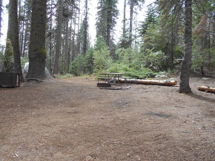
Beckler River campground offers standard sites, accommodating both tent and RV camping. Picnic tables, vault toilets and drinking water are provided.Access to the Skykomish River is available from the campground, and several sites are near the river's edge.
Natural Features
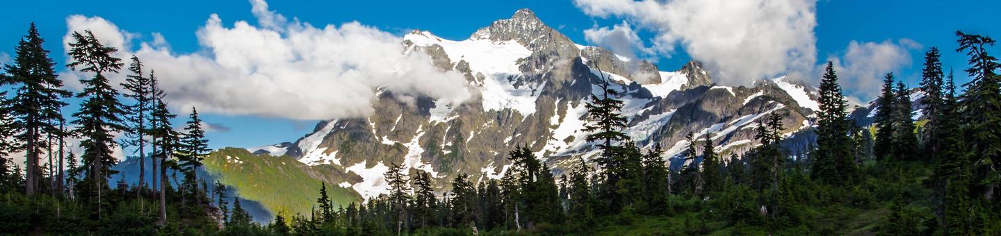
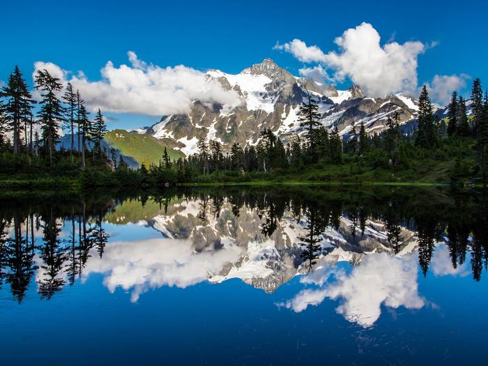
Hemmed in by several designated wilderness areas, the Mt. Baker-Snoqualmie National Forest showcases rugged peaks, sparkling alpine lakes and old-growth forests.Mt. Baker, the most prominent feature of the Mt. Baker Wilderness Area, dominates the landscape on a clear day. Rising to an elevation of 10,781 feet, this active volcano is perpetually snow-capped and mantled with an extensive network of creeping glaciers. Mt. Baker's summit, Grant Peak, is actually a 1,300-foot-deep mound of ice, which hides a massive volcanic crater.
The undeveloped wilderness, clean streams and diverse forests support a variety of wildlife, including mountain goats, coyotes, pine marten, a variety of migratory birds and native fish.
Nearby Attractions
Visitors enjoy the North Cascades and Mt. Rainer National Parks, where interpretive programs and exhibits offer education about the diverse landscape and history of the area.The spectacular Pacific Crest Trail (PCT), one of the world's premier National Scenic Trails, showcases some of North America's most fantastic scenery, winding its way its way from Mexico to Canada through California, Oregon and Washington, and is accessible near the campground.
contact_info
For facility specific information, please call (360) 386-8214.Charges & Cancellations
Once your reservation start date has begun, neither the Recreation.gov Contact Center nor the campground manager will be able to modify your reservation.
Boulder Creek Campground Campground
List of CampsitesOverview
Boulder Creek Campground sits along the banks of Boulder Creek in the stunning Mt. Baker-Snoqualmie National Forest. The unique setting offers many recreational activities and scenic views. Baker Lake is close by, and several hiking trails and climbing routes are within a short driving distance.Recreation
The surrounding area is a prime location for hiking, climbing, boating, fishing, picnicking and horseback riding in summer and early fall, and snowmobiling in the winter months. Baker Lake is a popular destination for boating, water skiing, canoeing, fishing and swimming. Anglers cast for a variety of fish species. Boat ramps are available at Horseshoe Cove, Swift Creek and Shannon Creek Campgrounds. The nearby Baker Lake Trail is an easy family hike that begins in a majestic stand of Douglas fir. In 1843, a small eruption of Mt. Baker caused a forest fire, and visitors can still see the burned snags of virgin cedar trees that once dominated the area. The trail contours above the eastern shoreline of Baker Lake. The Shadow of the Sentinels Trail begins just south of the campground. This accessible interpretive trail winds through a 500-year old ancient forest. Displays along the path explain the dynamics of the forest. The trail is constructed of asphalt and boardwalks with grades no greater than 8%.Facilities
Boulder Creek Campground accommodates both tent and RV campers, and contains a group site. Picnic tables, campfire rings and vault toilets are provided, but drinking water and hookups are not available. Visitors must bring their own supply of water.Natural Features
The Mt. Baker-Snoqualmie National Forest showcases rugged peaks, sparkling alpine lakes and old-growth forests, providing visitors with unique and surprising landscapes. Mt. Baker, the most prominent feature of the Mt. Baker Wilderness, dominates the landscape on a clear day. Rising to an elevation of 10,781 feet, the active volcano is perpetually snow-capped and mantled with an extensive network of creeping glaciers. Mt. Baker's summit, Grant Peak, is a 1,300-foot-deep mound of ice, which hides a massive volcanic crater. Wildlife in the area includes mountain goats traversing the higher elevations to squirrels and black bears in the forests. Migratory birds and native fish find ample habitat in the varied ecosystems as well.Nearby Attractions
Hike in the mountains above the lake in the Mt. Baker National Recreation Area or Mt. Baker Wilderness or take some time to visit North Cascades National Park. This unique park features a deep blue lake surrounded by sheer, 2,000' cliffs, two picturesque islands and a violent volcanic past. Hiking trails, a visitor center and educational programs are available.contact_info
For facility specific information, please call (360) 386-8214.Charges & Cancellations
Once your reservation start date has begun, neither the Recreation.gov Contact Center nor the campground manager will be able to modify your reservation.
The Dalles Campground Campground
List of CampsitesOverview
Situated on the banks of the White River in Mt. Baker-Snoqualmie National Forest, Dalles Campground offers visitors stunning scenery and access to a multitude of recreational activities within the Cascade region.Scattered beneath a towering canopy of diverse forest, the sites in this campground are widely-spaced and many are at the water's edge.
Recreation
Hiking and fishing top the list of recreational activities in the area.For visitors wanting a glimpse at the wonders of the area, hikes for all levels and abilities abound. For a shorter hike, the John Muir Nature Trail is a half-mile, barrier-free nature trail that begins at the historic picnic shelter near the entrance of the campground.
Marking the beginning of the Dalles River View trail at the west end of the campground loop is the "Big Tree," a 700 year-old Douglas fir that measures 9.5 feet in diameter.
Anglers will enjoy fly fishing on the White River and its tributaries, as it sustains several species of salmon and trout.
Facilities
Dalles campground offers standard sites and is able to accommodate tents or RVs.Picnic tables and campfire rings with grills are available at each site, and vault toilets and drinking water are accessible throughout the campground.
A covered historic picnic shelter, constructed by the Civilian Conservation Corps, may be reserved, otherwise it is available on a first-come first-serve basis.
Natural Features
Hemmed in by several designated wilderness areas, the Mt. Baker-Snoqualmie National Forest showcases rugged peaks, sparkling alpine lakes and old-growth forests, providing visitors with a variety of scenic landscapes.Mt. Rainer, the highest mountain in Washington and the Cascades range, dominates the landscape on a clear day. Rising to an elevation of 14,411 feet, the stratovolcano is perpetually snow-capped, boasting a total of 36-square miles of snowfields and glaciers. Two volcanic craters top the summit of this magnificent peak.
Flowing water from ice caves at the base of Emmons Glacier in Mt. Rainer National Park is the source of the White River, which enters the forest and joins up with Huckleberry Creek just below the Dalles Campground.
Wildlife in the area include mountain goats, coyotes, pine marten and a variety of migratory birds and native fish.
contact_info
For facility specific information, please call (360) 386-8214.Nearby Attractions
Visitors enjoy the North Cascades and Mt. Rainer National Parks, where interpretive programs and exhibits offer education about the diverse landscape and history of the area.Charges & Cancellations
Once your reservation start date has begun, neither the Recreation.gov Contact Center nor the campground manager will be able to modify your reservation.
Denny Creek Campground Campground
List of CampsitesOverview
Situated near the south fork of the Snoqualmie River in Mt. Baker-Snoqualmie National Forest, Denny Creek Campground offers visitors stunning scenery and easy access to an abundance of recreational activities in the Northern Cascade Range.Campsites sit beneath a canopy of forest, and a few are sprinkled at the banks of Lodge Creek, which flows into the Snoqualmie.
Recreation
In addition to being a prime location for hiking, fishing, picnicking and horseback riding in summer and early fall, Denny Creek offers excellent skiing and snowshoeing in the winter months.The Asahel Curtis Nature Trail, named for one of Washington's most renowned nature photographers, is located nearby. This trail is a short, easy walk through one of the last remaining stands of old growth forest in the Snoqualmie Valley. The trail crosses Humpback Creek several times before rising gently into a grove of mature Douglas-fir, western hemlock and western red cedar. Mosses, ferns, orchids and a large variety of other wildflowers abound on the forest floor.
Facilities
Denny Creek Campground offers 24 reservable campsites, including one group site. Picnic tables, flush toilets and drinking water are also available, as well as electrical hook-ups at a handful of sites.Natural Features
Hemmed in by several designated wilderness areas, this national forest showcases rugged peaks, sparkling alpine lakes and old-growth forests, providing visitors with a variety of scenic landscapes.On a clear day visitors can spot Mt. Baker, the most prominent feature of the Mt. Baker Wilderness Area. Rising to an elevation of 10,781 feet, this active volcano is perpetually snow-capped and mantled with an extensive network of creeping glaciers. Mt. Baker's summit, Grant Peak, is actually a 1,300-foot-deep mound of ice, which hides a massive volcanic crater.
Wildlife in the area include mountain goats, coyotes, pine marten and a variety of migratory birds and native fish.
contact_info
For facility specific information, please call (360) 386-8214.Nearby Attractions
Denny Creek Road, a historic wagon route used by early settlers to cross Snoqualmie Pass, can be accessed from milepost 47.The Verlot Public Service Center, near the South Fork Stillaguamish River, was built by the Civilian Conservation Corps from 1933 to 1942. Verlot`s handsome buildings reflect the architectural style and fine craftsmanship of the era and are listed on the National Register of Historic Places.
Charges & Cancellations
Once your reservation start date has begun, neither the Recreation.gov Contact Center nor the campground manager will be able to modify your reservation.
Douglas Fir Campground Campground
List of CampsitesOverview
Situated on the banks of North Fork Nooksack River in Mt. Baker-Snoqualmie National Forest, Douglas Fir Campground offers stunning scenery and access to numerous recreational activities popular in the north Cascades Mountains in Washington.Recreation
The campground provides a prime location for hiking and picnicking in summer and early fall. Horseshoe Bend Trail is an easy forest hike along the Mt. Baker Scenic Byway, highlighting old-growth forests, gushing whitewater and forest wildflowers. Whitewater rafting enthusiasts put in at the trailhead, and experienced kaykers can be seen on rapids as the trail follows the North Fork of the Nooksack River upstream past a stunning view of Church Mountain. Hikers and backpackers are especially fortunate to have access to a variety of trails near the campground and in the surrounding Mt. Baker Wilderness area. One of the most popular hikes in the Mt. Baker Ranger District is the Skyline Divide Trail. This trail climbs steadily for two miles through forest into lush, open meadows with sweeping views of glacier-draped Mt. Baker. The trail then wanders along Skyline Divide for another 2 miles, offering views of rivers, forests and countless peaks.Facilities
Douglas Fir Campground offers standard sites, accomodating tents and RVs. Several campsites are located at the river's edge, while others are shaded by a mature, mixed conifer forest. A historic sheltered picnic area, constructed by the Civilian Conservation Crew, is also available for reservation. Vault toilets and drinking water are available Individual sites are equipped with picnic tables, campfire rings and tent pads.Natural Features
Hemmed in by several designated wilderness areas, the Mt. Baker-Snoqualmie National Forest showcases rugged peaks, sparkling alpine lakes and old-growth forests, providing visitors with a variety of scenic landscapes. On a clear day visitors can spot Mt. Baker, the most prominent feature of the Mt. Baker Wilderness Area. Rising to an elevation of 10,781 feet, this active volcano is perpetually snow-capped and mantled with an extensive network of creeping glaciers. Mt. Baker's summit, Grant Peak, is actually a 1,300-foot-deep mound of ice, which hides a massive volcanic crater. Wildlife in the area include a variety of salmon species, elk, bald eagle and black tail deer. Migratory birds and black bears find ample habitat in the surrounding ecosystems.Nearby Attractions
Visitors enjoy hiking, picnicking and photography in the Heather Meadows area located along the upper reaches of the Mt. Baker Scenic Byway, SR 542. Many popular hikes and climbing routes are located in the surrounding Mt. Baker Wilderness and backpackers enjoy visiting the northern reaches of North Cascades National Park.contact_info
For facility specific information, please call (360) 386-8214.Charges & Cancellations
Once your reservation start date has begun, neither the Recreation.gov Contact Center nor the campground manager will be able to modify your reservation.
Excelsior Group Camp Campground
List of CampsitesOverview
Located near the rushing Nooksack River in Mt. Baker-Snoqualmie National Forest, Excelsior Group Camp offers access to numerous recreational activities popular in the north Cascades Mountains in Washington state.Recreation
The area surrounding the campground is prime location for hiking, fishing and picnicking in summer and early fall.Hikers and backpackers are especially fortunate to have access to a variety of trails near the campground and in the surrounding areas.
Horseshoe Bend Trail is an easy forest hike along the Mt. Baker Scenic Byway, highlighting old-growth forests, gushing whitewater rapids and forest wildflowers. The trail follows the North Fork of the Nooksack River upstream to a stunning view of East Church Mountain. The trailhead can be accessed from the nearby Douglas Fir campground.
Another popular hike in the Mt. Baker Ranger District is the Skyline Divide Trail. This trail climbs steadily for two miles through forest into lush, open, flower-filled meadows with stellar views of glacier-draped Mt. Baker. The trail then wanders along Skyline Divide for another 1.5 miles, offering views of rivers, forests and countless peaks.
Facilities
There are two large group sites in the campground. Site A will sleep 50 people and has a group fire ring along with picnic tables ant fire pits at the tent sites. Site B accommodates 50 people and has picnic tables and fire pits. Vault toilets are also provided.
Natural Features
The Mt. Baker-Snoqualmie National Forest showcases rugged peaks, sparkling alpine lakes and old-growth forests. Mt. Baker, the most prominent feature of the nearby Mt. Baker Wilderness, rises to an elevation of 10,781 feet. This active volcano is perpetually snow-capped and mantled with an extensive network of creeping glaciers. Mt. Baker's summit, Grant Peak, is actually a 1,300-foot-deep mound of ice, which hides a massive volcanic crater. Fed by the high snowfields and glaciers of Mt. Baker, Mt.Shuksan and the Twin Sisters range, the Nooksack River system provides habitat for many species. Wildlife in the area includes five native salmon species, elk, bald eagles and black tailed deer. Migratory birds and black bears find ample habitat in the surrounding ecosystems.Nearby Attractions
Visitors enjoy hiking, picnicking and photography in the Heather Meadows area located along the upper reaches of the Mt. Baker Scenic Byway, SR 542. Many popular hikes and climbing routes are located in the surrounding Mt. Baker Wilderness and backpackers enjoy visiting the northern reaches of North Cascades National Park.contact_info
For facility specific information, please call (360) 386-8214.Gold Basin Campground Campground
List of CampsitesOverview
Gold Basin Group Campground sits near the banks of the tranquil South Fork of the Stillaguamish River, close to several wilderness areas and hiking trails, offering visitors opportunities to experience both the serene and wild aspects of the Cascade region.Gold Basin is the largest campground on the Mountain Loop Highway and offers the most developed and accessible camping experience.
Recreation
In addition to being a prime location for hiking, biking, fishing, picnicking and horseback riding in summer and early fall, Gold Basin offers excellent skiing and snowshoeing in the winter months.A large, open field offers opportunities for sports and group activities.
For visitors wanting to learn more about the natural and cultural history of the area, the Gold Basin Mill Pond interpretive trail is located across the street from the campground. This interpretive site includes a short, barrier-free trail that passes by mill relics and ends on a floating viewpoint. Interpretive signs discuss the history of the mill and the wildlife in the area.
Facilities
This is a large campground with 99 reservable sites, including one large group site that can accommodate up to 75 guests.Picnic areas, trails and open spaces, along with the conveniences of firewood, drinking water, showers and flush toilets, give visitors the opportunity to enjoy the outdoors while still having many of the conveniences of home.
Natural Features
Old-growth forests of cedar, fir and hemlock line the wide, gently-flowing Stillaguamish River and tower over trails winding through moss-covered rocks.On a clear day visitors can spot Mt. Baker, the most prominent feature of the Mt. Baker Wilderness Area. Rising to an elevation of 10,781 feet, this active volcano is perpetually snow-capped and mantled with an extensive network of creeping glaciers. Mt. Baker's summit, Grant Peak, is actually a 1,300-foot-deep mound of ice, which hides a massive volcanic crater.
The surrounding undeveloped wilderness, clean streams and diverse forests support an abundance of wildlife. A multitude of mammals, birds, amphibians and reptiles make their homes here, and the area sustains more rare species like lynx, moose, wolves and wolverine.
contact_info
For facility specific information, please call (360) 386-8214.Nearby Attractions
Visitors enjoy the North Cascades and Mt. Rainer National Parks, where interpretive programs and exhibits offer education about the diverse landscape and history of the area.The spectacular Pacific Crest Trail (PCT), one of the world's premier National Scenic Trails, showcases some of North America's most fantastic scenery, winding its way its way from Mexico to Canada through California, Oregon and Washington, and is accessible near the campground.
Charges & Cancellations
Once your reservation start date has begun, neither the Recreation.gov Contact Center nor the campground manager will be able to modify your reservation.
Horseshoe Cove Campground Campground
List of CampsitesOverview
Horseshoe Cove Campground is nestled under a canopy of forest along the banks of Baker Lake. Located in the Mt. Baker-Snoqualmie National Forest which stretches along the west side of the Cascade Mountains between the Canadian border and Mt. Rainier National Park, this area is one of the most spectacular in the country, showcasing glacier-covered peaks, wide mountain meadows and old-growth forests.Recreation
In addition to being a prime location for boating, fishing, swimming, and picnicking , hikers and backpackers are especially fortunate to have access to a variety of spectacular trails along the lake and in the nearby Mt. Baker National Recreation Area.. The Baker Lake and Baker River Trails are family friendly hikes that are a short drive from the campground. The Baker Lake trail starts on the south end of the lake in a stand of Douglas fir and travels 13 miles above the eastern shoreline of Baker Lake. Anderson Point with views of Mt. Baker and Mt. Shuksan is 2.5 miles from the trailheadand is a popular boat in camp, backpacking destination and lunch spot. The Baker River Trail starts at the north end of the lake and follows the river 2.25 miles upstream, through large old-growth into North Cascades National Park.Facilities
There are 39 campsites at Horseshoe Cove Campground, including three large group sites.
With several sites located at the lake's edge, and others in close vicinity, this campground offers visitors the ideal opportunity to camp near the shoreline or under a canopy of trees.
A boat ramp, large sandy swim beach, trail, firewood are available at the campground.
Natural Features
From the lake on a clear day visitors will see Mt. Baker, the most prominent feature of the Mt. Baker Wilderness. Rising to an elevation of 10,781 feet, the active volcano from which the forest takes its name is perpetually snow-capped and mantled with an extensive network of creeping glaciers. Mt. Baker's summit, Grant Peak, is actually a 1,300-foot-deep mound of ice, which hides a massive volcanic crater.contact_info
For facility specific information, please call (360) 386-8214.Nearby Attractions
Hike in the mountains above the lake in the Mt. Baker National Recreation Area, or take some time to visit North Cascades National Park. This unique park is like no other place on earth. It features a deep blue lake surrounded by sheer, 2,000' cliffs, two picturesque islands and a violent volcanic past. Hiking trails, a visitor center and educational programs are available.Charges & Cancellations
Once your reservation start date has begun, neither the Recreation.gov Contact Center nor the campground manager will be able to modify your reservation.
Miller River Group Camp Campground
List of CampsitesOverview
Situated along the banks of the tranquil Miller River in Mt. Baker-Snoqualmie National Forest, the Miller River Group Campground offers some of the most stunning scenery in the northern Cascade Range in Washington.Nestled in a mixed conifer forest, the sites in this campground are widely spaced and within walking distance to the river, ideal for visitors wanting to enjoy the serenity of an isolated setting.
The campground also a great jumpoff point for a multitude of recreational activities along either the Skykomish River, in the Alpine Lakes Wilderness or near Stevens Pass.
Recreation
In addition to being a prime location for hiking and fishing in summer and early fall, Miller River offers excellent skiing and snowshoeing in the winter months.The Mt. Baker-Snoqualmie National Forest's 1,500 miles of trails can entice any hiker to get outdoors. From smooth paths meandering through deep quiet forests to challenging ascents up boulder-studded mountains, opportunities abound for every skill level.
The nearby Dorothy Lake Trail begins in a densely shaded forest for approximately 1.5 miles to the outlet of Dorothy Lake, then continues along the lake's eastern edge for another 2 miles to its inlet. From here the trail climbs steeply over a ridge and enters the Snoqualmie Ranger District. Permits are needed for both day-use hiking and overnight backpacking and camping in Wilderness Areas.
Facilities
Miller River Group Campground offers one reservable group site and 18 standard sites available on a first-come, first-served basis.Picnic tables, vault toilets, campfire rings and drinking water are available.
Natural Features
Hemmed in by several designated wilderness areas, the Mt. Baker-Snoqualmie National Forest showcases rugged peaks, sparkling alpine lakes and old-growth forests.Mt. Baker, the most prominent feature of the Mt. Baker Wilderness Area, dominates the landscape on a clear day. Rising to an elevation of 10,781 feet, the active volcano from which the forest takes its name is perpetually snow-capped and mantled with an extensive network of creeping glaciers. Mt. Baker's summit, Grant Peak, is actually a 1,300-foot-deep mound of ice, which hides a massive volcanic crater.
More than 700 lakes and mountain ponds dot the glacier-carved terrain of nearby Alpine Lake Wilderness. Tree-covered valleys give way to rocky ridges and rugged peaks along the crest of the Cascades. Many peaks and slopes are permanently cloaked in snowfields.
Congress designated the Alpine Lakes Wilderness in 1976 with a total of 362,789 acres, 117,862 of which lie in the Mt. Baker-Snoqualmie National Forest.
contact_info
For facility specific information, please call (360) 386-8214.Nearby Attractions
Visitors enjoy the North Cascades and Mt. Rainer National Parks, where interpretive programs and exhibits offer education about the diverse landscape and history of the area.The Pacific Crest Trail (PCT), one of the world's premier National Scenic Trails, showcases some of North America's most fantastic scenery, winding its way its way from Mexico to Canada through California, Oregon and Washington, and is accessible near the campground.
Charges & Cancellations
Once your reservation start date has begun, neither the Recreation.gov Contact Center nor the campground manager will be able to modify your reservation.
Money Creek Campground Campground
List of CampsitesOverview
Situated on the banks of the South Fork Skykomish River in Mt. Baker-Snoqualmie National Forest, Money Creek campground offers some of the most stunning scenery in the northern Cascade Range in Washington.Scattered beneath a towering canopy of old-growth forest, the sites in this campground are widely spaced and several are at the river's edge, making it an ideal setting for visitors wanting to camp in a private, rustic setting.
Recreation
In addition to being a prime location for hiking, and fishing in summer and early fall, Money Creek offers excellent skiing and snowshoeing in the winter months.The Mt. Baker-Snoqualmie National Forest's 1,500 miles of trails can entice any hiker to get outdoors. From smooth paths meandering through deep quiet forests to challenging ascents up boulder-studded mountains, opportunities abound for every skill level.
Nearby Barclay Creek Trail is an easier hike that follows Barclay Creek through diverse forest until reaching Barclay Lake at an elevation of 2,422 feet. Along the trail, hikers will encounter old growth trees, deer ferns, trillium, wood violets, bleeding hearts and salmon berries in season. Cedar boardwalks lead to a log bridge that crosses Barclay Creek. Once over the bridge, visitors will arrive at the lake and can take in an outstanding view of the north wall of Baring Mountain, dramatically rising 3,700 feet above the lake.
Facilities
Money Creek campground offers standard sites, accommodating both tent and RV camping. Picnic tables, vault toilets and drinking water are also available.The nearby Miller River/Money Creek Winter Sports Area is popular base for winter activities.
Natural Features
Hemmed in by several designated wilderness areas, the Mt. Baker-Snoqualmie National Forest showcases rugged peaks, sparkling alpine lakes and old-growth forests.Mt. Baker, the most prominent feature of the Mt. Baker Wilderness Area, dominates the landscape on a clear day. Rising to an elevation of 10,781 feet, the active volcano from which the forest takes its name is perpetually snow-capped and mantled with an extensive network of creeping glaciers. Mt. Baker's summit, Grant Peak, is actually a 1,300-foot-deep mound of ice, which hides a massive volcanic crater.
Wildlife in the area include mountain goats, coyotes, pine marten and a variety of migratory birds and native fish.
contact_info
For facility specific information, please call (360) 386-8214.Nearby Attractions
The nearby Stevens Pass Historic District offers education on the area's colorful railroad and mining history. The slopes at Steven's Pass Ski Area are only a two hour drive from Money Creek campground.Visitors enjoy the North Cascades and Mt. Rainer National Parks, where interpretive programs and exhibits offer education about the diverse landscape and history of the area.
Charges & Cancellations
Once your reservation start date has begun, neither the Recreation.gov Contact Center nor the campground manager will be able to modify your reservation.
Panorama Point Campground Campground
List of CampsitesOverview
Panorama Point campground is located on the western shore of Baker Lake in the stunning Mt. Baker-Snoqualmie National Forest. Situated on the west side of the Cascades in Washington, the surrounding area is one of the most spectacular in the country, showcasing glacier-covered peaks, wide mountain meadows and old-growth forests, rich in history and outdoor opportunities.Recreation
In addition to being a prime location for boating, fishing, swimming, and picnicking , hikers and backpackers are especially fortunate to have access to a variety of spectacular trails along the lake and in the nearby Mt. Baker National Recreation Area. The Baker Lake and Baker River Trails are family friendly hikes that are a short drive from the campground. The Baker Lake trail starts on the south end of the lake in a stand of Douglas fir and travels 13 miles above the eastern shoreline of Baker Lake. Anderson Point with views of Mt. Baker and Mt. Shuksan is 2.5 miles from the trailheadand is a popular boat in camp, backpacking destination and lunch spot. The Baker River Trail starts at the north end of the lake and follows the river 2.25 miles upstream, through large old-growth into North Cascades National Park.Facilities
With several sites located at the lake's edge and others in close vicinity, Panorama Point Campground offers visitors the ideal opportunity to camp near shoreline or under a canopy of trees.Panorama Point offers nine standard sites, accommodating both tent and RV camping. Picnic tables, vault toilets and drinking water are also available.
Natural Features
On a clear day, while driving to the campground, visitors will see Mt. Baker, the most prominent feature of the Mt. Baker Wilderness. Rising to an elevation of 10,781 feet, the active volcano from which the forest takes its name is perpetually snow-capped and mantled with an extensive network of creeping glaciers. Mt. Baker's summit, Grant Peak, is actually a 1,300-foot-deep mound of ice, which hides a massive volcanic crater.contact_info
For facility specific information, please call (360) 386-8214.Nearby Attractions
Hike in the mountains above the lake in the Mt. Baker National Recreation Area or Mt. Baker Wilderness, or take some time to visit North Cascades National Park. This unique park is like no other place on earth. It features a deep blue lake surrounded by sheer, 2,000' cliffs, two picturesque islands and a violent volcanic past. Hiking trails, a visitor center and educational programs are available.Charges & Cancellations
Once your reservation start date has begun, neither the Recreation.gov Contact Center nor the campground manager will be able to modify your reservation.
Park Creek Campground Campground
List of CampsitesOverview
Park Creek Campground sits along the banks of Park Creek in the stunning Mt. Baker-Snoqualmie National Forest. The unique setting offers many recreational activities and scenic views. Baker Lake is close by, and many hiking trails and climbing routes are within a short driving distance.Recreation
In addition to being a great basecamp for hiking, boating and fishing in summer and early fall, Park Creek can be a starting point for snowshoeing in the winter months. Trails in the area can entice any hiker to get outdoors. From smooth paths meandering through deep quiet forests to challenging ascents up boulder-studded mountains, opportunities abound for every skill level. Shadow of the Sentinels Trail, a barrier-free interpretive trail winding through dense forest growth, is a short drive away. Huge Douglas fir and cedar trees tower above a forest floor of ferns, moss and berry bushes, and interpretive signs along the route explain the dynamics of this 500-year-old ancient forest. The trail is constructed of asphalt and boardwalks with grades no greater than 8 percent. The nearby Baker Lake Trail is an easy family hike that begins in a majestic stand of Douglas fir. In 1843, a small eruption of Mt. Baker caused a forest fire, and visitors can still see the burned snags of virgin cedar trees that once dominated the area. The trail contours above the eastern shoreline of Baker Lake.Facilities
Park Creek campground offers standard sites, accommodating both tent and RV camping. The campground is equipped with tables, vault toilets and campfire rings with grills.Natural Features
The Mt. Baker-Snoqualmie National Forest showcases rugged peaks, sparkling alpine lakes and old-growth forests, providing visitors with unique and surprising landscapes. Mt. Baker, the most prominent feature of the Mt. Baker Wilderness, dominates the landscape on a clear day. Rising to an elevation of 10,781 feet, the active volcano is perpetually snow-capped and mantled with an extensive network of creeping glaciers. Mt. Baker's summit, Grant Peak, is a 1,300-foot-deep mound of ice, which hides a massive volcanic crater. Wildlife in the area includes mountain goats traversing the higher elevations to squirrels and black bears in the forests. Migratory birds and native fish find ample habitat in the surrounding ecosystems.Nearby Attractions
Hike in the mountains above the lake in the Mt. Baker National Recreation Area or Mt. Baker Wilderness, or take some time to visit North Cascades National Park. This unique park is like no other place on earth. It features a deep blue lake surrounded by sheer, 2,000' cliffs, two picturesque islands and a violent volcanic past. Hiking trails, a visitor center and educational programs are available.contact_info
For facility specific information, please call (360) 386-8214.Charges & Cancellations
Once your reservation start date has begun, neither the Recreation.gov Contact Center nor the campground manager will be able to modify your reservation.
Shannon Creek Campground Campground
List of CampsitesOverview
Shannon Creek Campground is nestled along the western shore of Baker Lake in the Mt. Baker-Snoqualmie National Forest on the west side of the Cascades. The area is one of the most spectacular in the country, showcasing glacier-covered peaks, broad mountain meadows and old-growth forests.Recreation
The surrounding area is a prime location for hiking, climbing, boating, fishing, picnicking and horseback riding in summer and early fall, and snowmobiling in the winter months. Baker Lake is a popular destination for boating, water skiing, canoeing, fishing and swimming. Anglers cast for a number of fish species. The nearby Baker Lake and Baker River Trails are family friendly hikes that wind through majestic old growth Douglas Fir and western red cedar trees. The Baker Lake trail contours above the eastern shoreline of Baker Lake. The Baker River Trail leads to North Cascades National Park.Facilities
Shannon Creek Campground offers single and double-family sites for both tent and RV camping. Picnic tables, campfire rings, vault toilets and drinking water are provided. No electrical hookups are available.Natural Features
Rugged peaks, scenic rivers and abundant wildlife define the Mt. Baker-Snoqualmie National Forest and surrounding designated wilderness areas. On a clear day visitors can see Mt. Baker, which rises to an elevation of 10,781 feet. The active volcano is perpetually snow-capped. Mt. Baker's summit, Grant Peak, is actually a 1,300-foot-deep mound of ice, which hides a massive volcanic crater.Wildlife in the area ranges from mountain goats in the higher elevations to pine marten and porcupine on the forest floor. Migratory birds and native fish find ample habitat in the varied ecosystems as well.
Nearby Attractions
Hike in the mountains above the lake in the Mt. Baker National Recreation Area or Mt. Baker Wilderness, or take some time to visit North Cascades National Park. This unique park is like no other place on earth. It features a deep blue lake surrounded by sheer, 2,000' cliffs, two picturesque islands and a violent volcanic past. Hiking trails, a visitor center and educational programs are available.contact_info
For facility specific information, please call (360) 386-8214.Charges & Cancellations
Once your reservation start date has begun, neither the Recreation.gov Contact Center nor the campground manager will be able to modify your reservation.
Silver Fir Campground Campground
List of CampsitesOverview
Silver Fir Campground is situated along the North Fork Nooksack River in Mt. Baker-Snoqualmie National Forest. The area offers stunning scenery and access to numerous recreational activities within the North Cascades in Washington.Recreation
The campground provides a prime location for hiking and picnicking in summer and early fall and is a non-motorized Sno-Park in the winter. Hikers and backpackers are especially fortunate to have access to a variety of trails near the campground and in the surrounding Mt. Baker Wilderness area. Trails accessed from Hannegan Pass Road, less than a mile from the campground, lead into stunning scenery in the Mt. Baker Wilderness and North Cascades National Park.Facilities
Silver Fir Campground is a smaller campground, offering sites to accommodate tents and RVs. A group picnic shelter for up to 25 people is also available. Picnic tables and campfire rings with grills are provided, as are vault toilets and drinking water. No electrical hookups are available. Groceries, firewood and other conveniences are available 20 minutes away in the nearby community of Glacier.Natural Features
The Mt. Baker-Snoqualmie National Forest showcases rugged peaks, sparkling alpine lakes and old-growth forests, providing visitors with unique and surprising landscapes. Mt. Baker, the most prominent feature of the Mt. Baker Wilderness, dominates the landscape on a clear day. Rising to an elevation of 10,781 feet, the active volcano is perpetually snow-capped and mantled with an extensive network of creeping glaciers. Mt. Baker's summit, Grant Peak, is a 1,300-foot-deep mound of ice, which hides a massive volcanic crater. Wildlife in the area includes mountain goats traversing the higher elevations to squirrels and black bears in the forests. Migratory birds and native fish find ample habitat in the varied ecosystems as well.Nearby Attractions
Visitors enjoy hiking, picnicking and photography in the Heather Meadows area located along the upper reaches of the Mt. Baker Scenic Byway, SR 542. Many popular hikes and climbing routes are located in the surrounding Mt. Baker Wilderness and backpackers enjoy visiting the northern reaches of North Cascades National Park.contact_info
For facility specific information, please call (360) 386-8214.Charges & Cancellations
Once your reservation start date has begun, neither the Recreation.gov Contact Center nor the campground manager will be able to modify your reservation.
Tinkham Campground Campground
List of CampsitesOverview
Tinkham Campground is located along the South Fork Snoqualmie River in Mt. Baker-Snoqualmie National Forest. It offers some of the most stunning scenery in Washington's North Cascades, as well as easy access to an abundance of recreational activities.Recreation
The surrounding area is a prime location for hiking, fishing, picnicking and horseback riding in summer and early fall. In winter, visitors can take advantage of skiing and snowshoeing opportunities.A handful of hiking trails lie within a short driving distance, making Tinkham an ideal setting for both individual and family camping excursions. The 0.5-mile Tinkham Discovery Trail is an easy, family-friendly nature path. It weaves through fallen, moss-covered trees to a small pond. Children love investigating the insects, wildflowers and fungi along the trail.
Facilities
Tinkham Campground offers single-family sites, a few of which are accessible. Picnic tables and campfire rings with grills are provided, as are vault toilets and drinking water. No electrical hookups are available.Natural Features
The campground sits alongside the river, in a towering canopy of Douglas fir, cedar and western hemlock, providing abundant shade.Rugged peaks, scenic rivers and abundant wildlife define the Mt. Baker-Snoqualmie National Forest and surrounding designated wilderness areas. On a clear day visitors can see Mt. Baker, which rises to an elevation of 10,781 feet. The active volcano is perpetually snow-capped. Mt. Baker's summit, Grant Peak, is actually a 1,300-foot-deep mound of ice, which hides a massive volcanic crater.
Wildlife in the area ranges from mountain goats in the higher elevations to coyotes and pine martens in the forests. Migratory birds and native fish find ample habitat in the varied ecosystems as well.
Nearby Attractions
Mount Rainier National Park is about an hour away. This beautiful park offers fantastic glimpses of glaciers, subalpine ecology and volcanic landscapes. Hiking and scenic driving are the area's most popular activities.contact_info
For facility specific information, please call (360) 386-8214.Charges & Cancellations
Once your reservation start date has begun, neither the Recreation.gov Contact Center nor the campground manager will be able to modify your reservation.
Turlo Campground Campground
List of CampsitesOverview
Turlo Campground is located just off the Mountain Loop Highway in the Mt.Baker-Snoqualmie National Forest. The campground is nestled in tall firs, cedars and hemlocks, adjacent to the south fork of the Stillaguamish River.The location offers individuals and families a tranquil camping experience with plenty of opportunities to fish, enjoy the river or relax at their campsite.
Recreation
The Mt. Baker-Snoqualmie National Forest has 1,500 miles of trails, ranging from smooth paths through deep, quiet forests to challenging ascents up boulder-studded mountains. Hiking opportunities abound for every skill level.The Mt. Dickerman Trail, close to the campground, switchbacks steeply for 3 miles through a dark forest to an alpine meadow, which was replanted in 1915 after a major forest fire. From this point, the trail rises above the timberline to an alpine meadow alive with masses of wildflowers in July and August.
The trail is generally in good condition, and spectacular views can be seen from all directions as the trail climbs to the 5,723 foot summit.
Facilities
Turlo Campground offers standard sites, accommodating both tent and RV camping. Picnic tables, flush toilets and drinking water are also available, however there are no electrical hook-ups.Access to the Stillaguamish River is available from the campground.
Natural Features
Situated on the west side of the Cascades between the Canadian border and Mt. Rainier National Park, Mt. Baker-Snoqualmie National Forest is one of the most spectacular in the the country, showcasing glacier-covered peaks, wide mountain meadows and old-growth forests, rich in history and outdoor opportunities.On a clear day, visitors will see Mt. Baker, the most prominent feature of the Mt. Baker Wilderness Area. Rising to an elevation of 10,781 feet, the active volcano from which the forest takes its name, is perpetually snow-capped and mantled with an extensive network of creeping glaciers. Mt. Baker's summit, Grant Peak, is actually a 1,300-foot-deep mound of ice, which hides a massive volcanic crater.
Old-growth forests line the wide, gently-flowing river, known for its salmon run. Salmon and other species including, chinook, coho, chum, pink, and sockeye salmon, steelhead trout, sea-run cutthroat, and bull trout, use the Stillaguamish and its tributaries for spawning.
contact_info
For facility specific information, please call (360) 386-8214.Nearby Attractions
Visit or stay in one of the historic lookouts in the area. Lookouts are tangible symbols of Forest Service heritage, perched on high peaks with unobstructed views where they have been used throughout the years to detect and control fires in remote wildlands.Take some time to visit nearby Mount Rainer National Park. Considered a wonderland, the park offers a fantasic glimpse into glaciers, subalpine ecology, and volcanic landscapes typical in the region.
Discover the Verlot Public Service Center, near the South Fork Stillaguamish River. Built by the Civilian Conservation Corps from 1933 to 1942, Verlot`s handsome buildings reflect the architectural style and fine craftsmanship of that era and are listed on the National Register of Historic Places.
Charges & Cancellations
Once your reservation start date has begun, neither the Recreation.gov Contact Center nor the campground manager will be able to modify your reservation.
Verlot Campground Campground
List of CampsitesOverview
Verlot Campground is located just off the Mountain Loop Highway in the stunning Mt. Baker-Snoqualmie National Forest.Situated on the west side of the Cascades between the Canadian border and Mt. Rainier National Park, this area is one of the most spectacular in the the country, showcasing glacier-covered peaks, wide mountain meadows and old-growth forests, rich in history and outdoor opportunities.
Verlot is a relatively quiet camp, and its close proximity to the South Fork Stillaguamish River offers an ideal setting for visitors wanting to enjoy the serenity of the flowing water or the easy access to fishing.
Recreation
The Mt. Baker-Snoqualmie National Forest has 1,500 miles of trails, ranging from smooth paths through deep, quiet forests to challenging ascents up boulder-studded mountains. Hiking opportunities abound for every skill level.The Mt. Dickerman Trail, located near the campground, switchbacks steeply for 3 miles through a dark forest to an alpine meadow, replanted in 1915 after a major forest fire. From this point, the trail rises above the timberline to an alpine meadow alive with wildflowers in July and August.
The trail is in generally good condition, and spectacular views can be seen from all directions as the trail climbs to the 5723 foot summit.
Facilities
Verlot Campground offers standard sites, accommodating both tent and RV camping. Picnic tables, flush toilets and drinking water are also available, however there are no electrical hook-ups.Access to the Stillaguamish River and Benson Creek is available from the campground.
Natural Features
The Mt. Baker-Snoqualmie National Forest offers visitors the chance to discover, or rediscover nature on a personal level. Rugged peaks, scenic rivers, and interesting wildlife define the forest and surrounding designated wilderness areas.On a clear day visitors will see Mt. Baker, the most prominent feature of the Mt. Baker Wilderness Area. Rising to an elevation of 10,781 feet, the active volcano from which the forest takes its name is perpetually snow-capped and mantled with an extensive network of creeping glaciers. Mt. Baker's summit, Grant Peak, is actually a 1,300-foot-deep mound of ice, which hides a massive volcanic crater.
On the banks of the Stillaguamish River, visitors can explore a unique ecosystem typical of the area. Old-growth forests line the wide, gently-flowing river, known for its salmon run. Populations of chinook, coho, chum, pink, and sockeye spawn in the river and its tributaries.
contact_info
For facility specific information, please call (360) 386-8214.Nearby Attractions
Visit or stay in one of the historic lookouts in the area. Lookouts are tangible symbols of Forest Service heritage, perched on high peaks with unobstructed views, where they have been used throughout the years to detect and control fires in remote wildlands.Take some time to visit nearby Mount Rainer National Park. Considered a wonderland, the park offers a fantastic glimpse into glaciers, subalpine ecology, and volcanic landscapes typical in the region.
Discover the Verlot Public Service Center, near the South Fork Stillaguamish River. Built by the Civilian Conservation Corps from 1933 to 1942, Verlot`s handsome buildings reflect the architectural style and fine craftsmanship of that era and are listed on the National Register of Historic Places.
Charges & Cancellations
Once your reservation start date has begun, neither the Recreation.gov Contact Center nor the campground manager will be able to modify your reservation.
Silver Springs Campground Campground
List of CampsitesOverview
Silver Springs Campground is situated on the banks of the scenic White River in Mt. Baker-Snoqualmie National Forest, just outside Mt. Rainier National Park's North Arch entrance. Silver Springs offers visitors stunning scenery and access to a multitude of recreational activities.Recreation
The White River sustains populations of salmon and trout, making it a great spot for fishing. A natural spring flows through the campground as well.Hiking and climbing top the list of recreational activities in the surrounding area. The 0.5-mile, accessible John Muir Nature Trail begins at nearby Dalles Campground. Visitors enjoy gazing up the "Big Tree," at an old-growth Douglas fir tree inside Dalles. This giant measures 9.5 feet in diameter and is over 700 years old. The tree stands at the beginning of the Dalles River View Trail, originating at the west end of the campground loop.
Local Crystal Mountain Trail begins about five miles southwest of the campground. It climbs 1,600 feet in elevation through clear-cut areas and second-growth forest before breaking out to expansive views of the White River Valley and Mt. Rainier. The trail continues to climb along the ridge, showcasing wildflowers in early June and huckleberries in early August.
Facilities
Silver Springs Campground offers both standard and accessible sites and accommodates tents or RVs. A group picnic shelter is also available. Picnic tables and campfire rings with grills are provided, as are flush and vault toilets and drinking water. No electrical hookups are available.Natural Features
The campground's widely-spaced sites are scattered in a beautiful section of old-growth forest, where many sit on the banks of the White River, which is sourced by flowing water from ice caves at the base of Emmons Glacier on Mt. Rainier.The Mt. Baker-Snoqualmie National Forest showcases rugged peaks, sparkling alpine lakes and old-growth forests. Several designated wilderness areas surround the forest.
Mt. Rainier, the highest peak in Washington and the Cascades Range, dominates the landscape on clear days. The volcano rises to an elevation of 14,411 feet and is perpetually snow-capped, boasting a total of 36-square miles of snowfields and glaciers.
Wildlife in the area ranges from mountain goats in the higher elevations to porcupines and pine martens in the forests. Migratory birds and native fish find ample habitat in the varied ecosystems.
contact_info
For facility specific information, please call (360) 386-8214.Nearby Attractions
Mount Rainier National Park offers fantastic glimpses of glaciers, subalpine ecology and volcanic landscapes. Hiking trails and scenic drives crisscross the park.Visit or stay in one of the historic lookouts in the area. Lookouts are tangible symbols of Forest Service heritage, perched on high peaks with unobstructed views where they have been used throughout the years to detect fires in remote forest lands.
Charges & Cancellations
Once your reservation start date has begun, neither the Recreation.gov Contact Center nor the campground manager will be able to modify your reservation.
Troublesome Creek Campground Campground
List of CampsitesOverview
This campground is located approximately 20 miles east of Index, Washington in the Mt. Baker-Snoqualmie National Forest. It offers guests a wonderful spot to take in the scenery and enjoy a multitude of recreational activities in the Northern Cascade Range.Sites are nestled in a mixed conifer forest on the banks of the scenic North Fork Skykomish River and its tributary, Troublesome Creek. Water is abundant in this area, offering visitors easy access to fishing, kayaking, and swimming. Guests will be lulled to sleep by its subtle, but ever-present gurgle.
This campground is ideal for escaping the hustle of everyday life to enjoy time with friends and family.
Recreation
At the campground, Troublesome Creek is a delight for exploring. A footbridge crosses the bubbling creek beneath towering pine and fir trees. For guests wanting to relax at the water's edge, or children searching for newness in nature, this is an ideal spot without even leaving the campground.The adjacent North Fork Skykomish River offers fishing for steelhead and salmon.
For those wanting to venture further, the Beckler Peak Trail may be included on the agenda. Located 10 miles from the town of Skykomish, this trail is challenging, but worth the effort, offering hikers the opportunity to view the diverse landscapes of the area from a variety of perspectives.
At the Jennifer Dunn Trailhead, the trail starts out on a decommissioned logging road, and climbs through young alder and vine maple to an expansive vista of the Skykomish Valley. The trail continues to switchback through huge trees and by the remains of a trapper's cabin. Climbing higher, and upon reaching the final ridge top through steep alpine forest, hikers will be in awe of the panoramic view of near and distant peaks.
Facilities
Troublesome Creek Campground offers standard sites, accommodating both tent and RV camping. Tent-only sites are available as well.The campground is equipped with picnic tables, vault toilets and drinking water. No electrical hook-ups are available. Firewood may be available for purchase.
Access to the Skykomish River is available from the campground, and several sites are near the river's edge.
Natural Features
The Mt. Baker-Snoqualmie National Forest showcases rugged peaks, sparkling alpine lakes, and old-growth forests, providing visitors with unique and surprising landscapes.Mt. Baker, the most prominent feature of the Mt. Baker Wilderness Area, dominates the landscape on a clear day. Rising to an elevation of 10,781 feet, the active volcano from which the forest takes its name is perpetually snow-capped and mantled with an extensive network of creeping glaciers. Mt. Baker's summit, Grant Peak, is actually a mound of ice 1,300 feet deep, which hides a massive volcanic crater.
Wildlife in the area includes mountain goats traversing the higher elevations, to coyotes and pine marten in the forests. Migratory birds and native fish find ample habitat in the varied ecosystems as well. These species, along with many others, depend on surrounding undeveloped wilderness, clean streams, and diverse forests to live.
contact_info
For facility specific information, please call (360) 386-8214.Charges & Cancellations
Once your reservation start date has begun, neither the Recreation.gov Contact Center nor the campground manager will be able to modify your reservation.
Beaver Creek Group Camp (Mt. Baker-Snoqualmie National Forest, WA) Campground
List of CampsitesOverview
Beaver Creek campground is a popular group camp situated along the Stillaguamish River, with a spectacular view of Big Four Mountain.Visitors traversing the scenic Mountain Loop Road through Mt. Baker-Snoqualmie National Forest will find the campground about 12 miles east of the Verlot Public Service Center, just past the small town of Silverton, Washington.
Fairly flat, surrounded by stands of old-growth forest and located near the bubbling Beaver Creek, this site is ideal for small group or family camping excursions.
Recreation
In addition to being a prime location for hiking, fishing, picnicking and horseback riding in summer and early fall, Beaver Creek offers excellent skiing and snowshoeing in the winter months.Hikers may want to explore the nearby Big Four Ice Caves Trail off of the Mountain Loop Highway. The trail ends with a view of the ice fields and the immense north face of the 6,153 foot Big Four Mountain. The caves are exposed during August and remain visible through October.
The nearby Gold Basin Mill Pond interpretive trail is also accessible from the campground. This interpretive site includes a short, barrier-free trail that passes by mill relics and ends on a floating viewpoint looking across the old millpond. Interpretive signs discuss the history of the mill and the wildlife in the area. The trail is located directly across from the Gold Basin Campground.
Facilities
The campground offers one large group campsite, making it a perfect setting for families or groups. The site can accommodate about 15 campers and is ideal for a mix of tents and RVs.The site is equipped with tables, tent pads and campfire rings with grills. Vault toilets are available, but there is no drinking water provided.
Natural Features
Located in the majestic Cascade region of Washington, the Mt. Baker-Snoqualmie National Forest offers visitors the chance to explore the region's rugged peaks, scenic rivers and dense forest and wilderness areas.Old-growth forests of cedar, fir and hemlock line the wide, gently-flowing Stillaguamish River and tower over trails of moss-covered boulders.
On a clear day visitors can spot Mt. Baker, the most prominent feature of the Wilderness Area. Rising to 10,781 feet, the active volcano is perpetually snow-capped and mantled with an extensive network of creeping glaciers. Mt. Baker's summit, Grant Peak, is actually a 1,300-foot-deep mound of ice, which hides a massive volcanic crater.
The diverse forest provides an excellent habitat for a variety of wildlife. In addition to being home for a multitude of mammals, birds, amphibians and reptiles, the area sustains more rare species such as lynx, moose, wolves, and wolverine. Grizzly bear sightings have been confirmed in the Cascade region, though black bears are more common.
Nearby Attractions
Visitors enjoy the North Cascades and Mt. Rainer National Parks, where interpretive programs and exhibits offer opportunities to learn about the diverse landscape and history of the area.The Pacific Crest Trail (PCT), one of the world's premier National Scenic Trails, showcases some of North America's most fantastic scenery, winding its way its way from Mexico to Canada through California, Oregon and Washington. The trail is accessible a short drive from the campground.
contact_info
For facility specific information, please call (360) 386-8214.Charges & Cancellations
Once your reservation start date has begun, neither the Recreation.gov Contact Center nor the campground manager will be able to modify your reservation.
Esswine Group Camp Campground
List of CampsitesOverview
Esswine Group Campground is located on the banks of the tranquil Stillaguamish River in The Mt. Baker-Snoqualmie National Forest. The camp is close to several wilderness areas and offers visitors opportunities to experience both the serene and wild aspects of the Cascade region.Recreation
In addition to being a prime location for hiking, fishing, picnicking and horseback riding in summer and early fall, Esswine offers excellent skiing and snowshoeing in the winter months.Anglers will enjoy fishing from the gently-flowing Stillaguamish River, which is known for its salmon run. Chinook, coho, chum, pink and sockeye salmon, steelhead trout, sea-run cutthroat and bull trout use the river and its tributaries for spawning.
Facilities
Esswine offers one large group campsite, making it a perfect setting for families or groups wanting privacy. The site can accommodate about 25 campers, and is ideal for a mix of tent and RV camping.The site is equipped with tables, tent pads and campfire rings with grills. Vault toilets are also available.
Natural Features
Old-growth forests of cedar, fir and hemlock line the wide, gently-flowing Stillaguamish River and tower over trails winding through moss-covered rocks.On a clear day visitors can spot Mt. Baker, the most prominent feature of the Mt. Baker Wilderness Area. Rising to an elevation of 10,781 feet, this active volcano is perpetually snow-capped and mantled with an extensive network of creeping glaciers. Mt. Baker's summit, Grant Peak, is actually a 1,300-foot-deep mound of ice, which hides a massive volcanic crater.
The surrounding undeveloped wilderness, clean streams and diverse forests support an abundance of wildlife. In addition to being home for a multitude of mammals, birds, amphibians and reptiles, the area sustains more rare species such as lynx, moose, wolves and wolverine. Grizzly bear sightings have been confirmed in the Cascade region, though black bear sightings are more common.
Nearby Attractions
Visitors enjoy the North Cascades and Mt. Rainer National Parks, where interpretive programs and exhibits offer education about the diverse landscape and history of the area.The spectacular Pacific Crest Trail (PCT), one of the world's premier National Scenic Trails, showcases some of North America's most fantastic scenery, winding its way its way from Mexico to Canada through California, Oregon and Washington, and is accessible near the campground.
contact_info
For facility specific information, please call (360) 386-8214.Charges & Cancellations
Once your reservation start date has begun, neither the Recreation.gov Contact Center nor the campground manager will be able to modify your reservation.
Coal Creek Group Camp Campground
List of CampsitesOverview
Coal Creek Group Campground sits along the scenic Mountain Loop Road in the Mt. Baker-Snoqualmie National Forest.Surrounded by stands of old-growth forest and located near the confluence the of the tranquil Stillaguamish River and bubbling Coal Creek, this site is ideal for small group or family camping excursions.
Recreation
Coal Creek is a prime location for hiking, fishing, picnicking and horseback riding in summer and early fall, and offers excellent skiing and snowshoeing in the winter months.Hikers may want to explore the nearby Big Four Ice Caves Trail off of the Mountain Loop Highway. The trail ends with a view of the ice fields and the immense north face of the 6,153 foot Big Four Mountain. The caves are exposed during August and remain visible through October.
The nearby Gold Basin Mill Pond interpretive trail is also accessible from the campground. This interpretive site includes a short, barrier-free trail that passes by mill relics and ends on a floating viewpoint looking across the old millpond. Interpretive signs discuss the history of the mill and the wildlife in the area. The trail is located directly across from the Gold Basin Campground.
Facilities
The campground offers one large group campsite, making it a perfect setting for families or groups wanting privacy. The site can accommodate about 25 guests and is ideal for tent mixed with RVs.The site is equipped with tables, tent pads, campfire rings with grills and vault toilets.
Natural Features
Located in the majestic Cascade region of Washington, the Mt. Baker-Snoqualmie National Forest showcases rugged peaks, scenic rivers and lush forests.The banks of the Stillaguamish River are lined with old-growth forests of cedar, fir and hemlock.
On a clear day visitors can spot Mt. Baker, the most prominent feature of the Mt. Baker Wilderness Area. Rising to an elevation of 10,781 feet, this active volcano is perpetually snow-capped and mantled with an extensive network of creeping glaciers. Mt. Baker's summit, Grant Peak, is actually a 1,300-foot-deep mound of ice, which hides a massive volcanic crater.
The surrounding undeveloped wilderness, clean streams and diverse forests support an abundance of wildlife. In addition to being home for a multitude of mammals, birds, amphibians and reptiles, the area sustains more rare species such as lynx, moose, wolves and wolverine. Grizzly bear sightings have been confirmed in the Cascade region, though black bear sightings are more common.
contact_info
For facility specific information, please call (360) 386-8214.Nearby Attractions
Visitors enjoy the North Cascades and Mt. Rainer National Parks, where interpretive programs and exhibits offer education about the diverse landscape and history of the area.The spectacular Pacific Crest Trail (PCT), one of the world's premier National Scenic Trails, showcases some of North America's most fantastic scenery, winding its way its way from Mexico to Canada through California, Oregon and Washington, and is accessible near the campground.
Charges & Cancellations
Once your reservation start date has begun, neither the Recreation.gov Contact Center nor the campground manager will be able to modify your reservation.
Wiley Creek Group Camp Campground
List of CampsitesOverview
Wiley Creek, a popular campground for youth groups and organizations, is situated in an old-growth Douglas fir forest with lovely shaded trails. It is the first group site located on the north side of Mountain Loop Road, about 5 miles east of the Verlot Public Service Center in the Mt. Baker-Snoqualmie National Forest.Whether visitors choose to hike on trails leading into towering forests or enjoy a moment of solitude on the banks of the nearby Stillaguamish River, this campround offers opportunities to experience both the serene and wild aspects of the Cascade region.
Recreation
In addition to being a prime location for hiking, fishing, picnicking, and horseback riding in summer and early fall, visitors can take advantage of skiing and snowshoeing in the winter months.Anglers enjoy fishing from the gently-flowing Stillaguamish River. The Stillaguamish sustains a large salmon and trout population including chinook, coho, chum, pink and sockeye salmon, steelhead trout, sea-run cutthroat and bull trout.
Gold Basin Mill Pond Interpretive Trail invites visitors to learn more about the natural and cultural history of the area. The short, accessible trail passes by mill relics and ends on a floating viewpoint, looking across the millpond. The trailhead is located directly across from Gold Basin Campground.
Facilities
Wiley Creek Campground has two group sites that can accomodate up to 20 people each, with Adirondack shelters, tables and rock barbeque pits. Vault toilets are provided but there is no drinking water. Visitors must bring their own supply.Group A has two Adirondacks. One shelter can accomodate 8 people on bunk beds and the second can sleep 12 on the attic floor. About 250 square feet are available on each floor.
Group B has a two-level shelter with about 400 square feet of space on each level.
Natural Features
The Mt. Baker-Snoqualmie National Forest offers visitors the chance to explore the region's rugged peaks, scenic rivers and interesting wildlife that comprise the forest and surrounding designated wilderness areas.Exploring the banks of the Stillaguamish River, one will find unique ecosystems typical for the area. Old-growth forests of cedar, fir, and hemlock line the wide, gently-flowing river, and tower over trails winding through moss-covered rocks.
On a clear day visitors will see Mt. Baker, the most prominent feature of the Mt. Baker Wilderness Area. The active volcano rises to an elevation of 10,781 feet, and is perpetually snow-capped and mantled with an extensive network of creeping glaciers. Mt. Baker's summit, Grant Peak, is actually a 1,300-foot-deep mound of ice, which hides a massive volcanic crater.
Undeveloped wilderness, clean streams, and diverse forests provide important habitat for wildlife, including birds, amphibians, reptiles and more rare species such as lynx, moose, wolves and wolverine.
Nearby Attractions
Traverse a portion of the spectacular Pacific Crest Trail (PCT), one of the world's premier National Scenic Trails. This trail showcases some of North America's most fantastic scenery as it winds its way from Mexico to Canada through California, Oregon and Washington.contact_info
For facility specific information, please call (360) 386-8214.Charges & Cancellations
Once your reservation start date has begun, neither the Recreation.gov Contact Center nor the campground manager will be able to modify your reservation.
Tulalip Group Camp Campground
List of CampsitesOverview
Situated a short distance from the banks of the Stillaguamish River and in close proximity to several wilderness areas, Tulalip Group Campground offers visitors the opportunity to experience both the serene and wild aspects of the Cascade region in Mt. Baker-Snoqualmie National Forest.Surrounded by stands of diverse forest and located in an open, flat area along the scenic Mountain Loop Road, this site is ideal for small group camping excursions.
Recreation
In addition to being a prime location for hiking, fishing, picnicking, and horseback riding in summer and early fall, visitors can take advantage of skiing and snowshoeing in the winter months.Anglers will enjoy fishing from the gently-flowing Stillaguamish River or neighboring Old Mill Pond. The Stillaguamish sustains a large salmon and trout population including chinook, coho, chum, pink, and sockeye salmon, steelhead trout, sea-run cutthroat and bull trout.
Fishing is best in the summer months, though crisp, autumn evenings provide a delightful backdrop for those looking to cast a line in greater solitude.
Facilities
There is only one site at the campground, making it a perfect setting for groups and family gatherings.The site is equipped with tables and campfire rings with grills. Vault toilets are available, but there is no drinking water. Visitors must bring their own water.
River access is available via a short trail from the campground.
Natural Features
The Mt. Baker-Snoqualmie National Forest offers visitors the chance to explore the region's rugged peaks, scenic rivers, and exciting wildlife in the forest and surrounding designated wilderness areas.On banks of the Stillaguamish River, visitors can explore portions of the unique ecosystems typical of the area. Old-growth forests of cedar, fir, and hemlock line the wide, gently-flowing river and tower over trails of underbrush and spring flowers.
On a clear day visitors will see Mt. Baker, the most prominent feature of the Mt. Baker Wilderness Area. Rising to an elevation of 10,781 feet, the active volcano from which the forest takes its name is perpetually snow-capped and mantled with an extensive network of creeping glaciers. Mt. Baker's summit, Grant Peak, is actually a 1,300-foot-deep mound of ice, which hides a massive volcanic crater.
Undeveloped wilderness, clean streams and diverse forests provide important habitat for wildlife to thrive in this region, including lynx, moose, wolves and wolverine.
contact_info
For facility specific information, please call (360) 386-8214.Nearby Attractions
Visit or stay in one of the historic lookouts in the area. Lookouts are tangible symbols of Forest Service heritage, perched on high peaks with unobstructed views, where they have been used throughout the years to detect and control fires in remote wildlands.Take some time to visit North Cascades National Park or Mt. Rainer National Park to learn about the diverse landscape and history of the area through interpretive programs and exhibits.
Traverse at least a portion of the spectacular Pacific Crest Trail (PCT), one of the world's premier National Scenic Trails. This trail showcases some of North America's most fantastic scenery, winding its way its way from Mexico to Canada through California, Oregon and Washington.
Charges & Cancellations
Once your reservation start date has begun, neither the Recreation.gov Contact Center nor the campground manager will be able to modify your reservation.
Boardman Group Camp Campground
List of CampsitesOverview
Boardman Group Campground is located about 8 miles east of the Verlot Public Service Center along scenic Mountain Loop Scenic Byway through Mt. Baker-Snoqualmie National Forest. The campground is located on the banks of the tranquil Stillaguamish River, in close proximity to several wilderness areas.Recreation
In addition to being a prime location for hiking, fishing, picnicking and horseback riding in summer and early fall, visitors can take advantage of skiing and snowshoeing in the winter months.Anglers enjoy fishing from the gently-flowing Stillaguamish River, which sustains populations chinook, coho, chum, pink and sockeye salmon, steelhead trout, sea-run cutthroat and bull trout.
Facilities
The campground offers just one site, making it a perfect setting for groups of up to 35 people. RVs are welcome. A small amount of traffic noise from the adjacent highway can be heard, but the river helps mask it.The site is equipped with tables and campfire rings with grills. Vault toilets are available, but there is no drinking water. Visitors must bring their own supply.
Natural Features
The Mt. Baker-Snoqualmie National Forest offers visitors the chance to explore the region's rugged peaks, scenic rivers, and interesting wildlife within the forest and surrounding designated wilderness areas.Visitors will find unique ecosystems along the banks of the Stillaguamish River. Old-growth forests of cedar, fir and hemlock line the wide, gently-flowing river and tower over trails winding through moss-covered rocks.
On a clear day visitors will see Mt. Baker, the most prominent feature of the Mt. Baker Wilderness Area. Rising to an elevation of 10,781 feet, the active volcano is perpetually snow-capped and mantled with an extensive network of creeping glaciers. Mt. Baker's summit, Grant Peak, is a 1,300-foot-deep mound of ice, which hides a massive volcanic crater.
Undeveloped wilderness, clean streams and diverse forests provide important habitat for wildlife, including birds, amphibians, reptiles and more rare species such as lynx, moose, wolves, and wolverine. Grizzly bear sightings have been confirmed in the Cascade region, though black bears are more common.
contact_info
For facility specific information, please call (360) 386-8214.Nearby Attractions
Traverse a portion of the spectacular Pacific Crest Trail (PCT), one of the world's premier National Scenic Trails. This trail showcases some of North America's most fantastic scenery as it winds its way from Mexico to Canada through California, Oregon and Washington.Charges & Cancellations
Once your reservation start date has begun, neither the Recreation.gov Contact Center nor the campground manager will be able to modify your reservation.
Swift Creek Campground Campground
List of CampsitesOverview
Swift Creek Campground is tucked into a mixed-conifer forest at the edge of Baker Lake in Mt. Baker-Snoqualmie National Forest.Recreation
In addition to being a prime location for hiking, boating, fishing, picnicking, and horseback riding in summer and early fall, Swift Creek offers opportunities for snowshoeing in the winter months. With a small beach on-site and access to Baker Lake, visitors will have plenty of opportunities to fish, kayak, canoe and swim. The nearby Baker Lake Trail is a family friendly hike that begins in a majestic stand of Douglas fir. In 1843, a small eruption of Mt. Baker caused a forest fire, and visitors can still see the burned snags of virgin cedar trees that once dominated the area. The trail contours above the eastern shoreline of Baker Lake.Facilities
Swift Creek offers campsites that accommodate either tents or RVs. There are two group sites that are reservable as well.Drinking water and vault toilets are available. The campground also has a day-use area at the lake's edge, equipped with picnic tables and grills.
There is a boat ramp and a marina on site.
Natural Features
The Mt. Baker-Snoqualmie National Forest showcases rugged peaks, sparkling alpine lakes and old-growth forests, providing visitors with unique and surprising landscapes. Mt. Baker, the most prominent feature of the Mt. Baker Wilderness, dominates the landscape on a clear day. Rising to an elevation of 10,781 feet, the active volcano is perpetually snow-capped and mantled with an extensive network of creeping glaciers. Mt. Baker's summit, Grant Peak, is a 1,300-foot-deep mound of ice, which hides a massive volcanic crater. Wildlife in the area includes mountain goats traversing the higher elevations to squirrels and black bears in the forests. Migratory birds and native fish find ample habitat in the varied ecosystems as well.contact_info
For facility specific information, please call (360) 386-8214.Nearby Attractions
Hike in the mountains above the lake in the Mt. Baker National Recreation Area or Mt. Baker Wilderness, or take some time to visit North Cascades National Park. This unique park is like no other place on earth. It features a deep blue lake surrounded by sheer, 2,000' cliffs, two picturesque islands and a violent volcanic past. Hiking trails, a visitor center and educational programs are available.Charges & Cancellations
Once your reservation start date has begun, neither the Recreation.gov Contact Center nor the campground manager will be able to modify your reservation.
BUCK CREEK CAMPGROUND Campground
List of CampsitesOverview
Situated on the banks of Buck Creek in Mt. Baker-Snoqualmie National Forest, Buck Creek campground offers stunning scenery and access to numerous recreational activities popular in the Northern Cascade Range in Washington.Scattered beneath a towering canopy of old-growth forest, the sites in this campground are secluded and within walking distance to the waterfront, making it an ideal setting for visitors wanting to camp in a private, rustic setting.
Recreation
The area surrounding this campground is prime location for hiking, fishing and picnicking in summer and early fall.Hikers and backpackers are especially fortunate to have access to a variety of spectacular trails near the campground and in the surrounding areas.
Several trailheads are located in the vicinity of Buck Creek campground, including Huckleberry Creek Trail. This lesser-known trail starts starts on an old spur road in second growth timber and follows Huckleberry Creek to the northeast boundary of Mt. Rainier National Park. For those looking for a more strenuous hike, the Lake James Trail continues into the park.
Facilities
Buck Creek campground offers 29 standard sites, including three that are for tents only. Sites are equipped with picnic tables and vault toilets.Natural Features
Hemmed in by several designated wilderness areas, the Mt. Baker-Snoqualmie National Forest showcases rugged peaks, sparkling alpine lakes and old-growth forests, providing visitors with a variety of scenic landscapes.Wildlife in the area includes mountain goats, porcupine, pine marten and a variety of migratory birds and native fish.
contact_info
For facility specific information, please call (360) 386-8214.Nearby Attractions
Charges & Cancellations
Once your reservation start date has begun, neither the Recreation.gov Contact Center nor the campground manager will be able to modify your reservation.
Marble Creek Campground Campground
List of CampsitesOverview
Situated on the banks of the scenic Cascade River in Mt. Baker-Snoqualmie National Forest, Marble Creek campground offers some of the most stunning scenery in the northern Cascade Range.Campsites are scattered beneath a towering canopy of diverse forest. They are widely spaced and within walking distance to the waterfront, making it an ideal setting for visitors wanting to camp in a private, rustic setting.
Recreation
In addition to being a prime location for hiking, fishing, picnicking and horseback riding in summer and early fall, Marble Creek offers excellent skiing and snowshoeing in the winter months.The area surrounding the campground can accommodate anyone from the novice hiker to the most experienced outdoor enthusiast.
Several trailheads for the overnight backpacker are located in the vicinity of the nearby town of Marblemount, including Hidden Lake Trail. Beginning in a forested setting, the trail climbs quickly to open meadows and grand views of the Cascade River. As it reaches higher elevations, it winds through angular slabs of granite and groupings of alpine fir. Hidden Lake and the Hidden Lake Lookout can be seen below from the pass.
Facilities
Marble Creek Campground can accommodate RV, trailer or tent-campers however water and electric hookups are not available. This is a NO WATER facility so campers will need to bring their own supply. All sites are equipped with a picnic table and campfire ring with grill and the campground has vault toilets available.Natural Features
Hemmed in by several designated wilderness areas, the Mt. Baker-Snoqualmie National Forest showcases rugged peaks, sparkling alpine lakes and old-growth forests.Mt. Baker, the most prominent feature of the area, dominates the landscape on a clear day. Rising to an elevation of 10,781 feet, the active volcano from which the forest takes its name is perpetually snow-capped and mantled with an extensive network of creeping glaciers. Mt. Baker's summit, Grant Peak, is actually a 1,300-foot-deep mound of ice, which hides a massive volcanic crater.
Flowing adjacent to this campground is the Cascade River, a tributary of the Skagit River, designated as a National Scenic River.
Wildlife in the area include mountain goats, coyotes, pine marten and a variety of migratory birds and native fish.
contact_info
For facility specific information, please call (360) 386-8214.Nearby Attractions
Visitors enjoy the North Cascades and Mt. Rainer National Parks, where interpretive programs and exhibits offer education about the diverse landscape and history of the area.The Verlot Public Service Center, near the South Fork Stillaguamish River, is a popular attraction. Built by the Civilian Conservation Corps from 1933 to 1942, Verlot`s handsome buildings reflect the architectural style and fine craftsmanship of that era and are listed on the National Register of Historic Places.
Charges & Cancellations
Once your reservation start date has begun, neither the Recreation.gov Contact Center nor the campground manager will be able to modify your reservation.
Sulphur Creek Campground Campground
List of CampsitesOverview
Sulphur Creek Campground is a primitive site in a beautiful forest along the banks of the scenic Suiattle River and Sulpher Creek. It is a remote haven set amongst towering old growth Douglas fir trees in the Mt. Baker-Snoquamie National Forest.Hikers frequently camp here to explore the many trails surrounding the facility. It has moderate, enjoyable summer temperatures throughout the camping season.
Recreation
The biggest draw to Sulphur Creek Campground is hiking. The well-known Suiattle Trail and numerous others begin within a few miles of the campground. The area is part of the North Cascades range.Facilities
This primitive site provides no drinking water, though there is a pit toilet. There are 20 individual campsites, each with a picnic table and fire ring. Campers may purchase supplies in the nearby town of Darrington.Natural Features
The Suiattle River is a federally designated National Wild and Scenic River. Though the glacier-fed water is too cold and the current too strong to swim in, the river creates a beautiful backdrop and soothing sounds for campers.Tall, old growth forest provide abundant shade for campers and habitat for black bears and other wildlife.
contact_info
For facility specific information, please call (360) 386-8214.Charges & Cancellations
Once your reservation start date has begun, neither the Recreation.gov Contact Center nor the campground manager will be able to modify your reservation.
Bedal Campground Campground
List of CampsitesOverview
Bedal Campground is located just off the Mountain Loop Highway in the stunning Mt. Baker-Snoqualmie National Forest.Nestled in canopy of forest along the rushing water of the Sauk River, this campground offers visitors a primitive camping experience and access to a wide range of recreational activities.
Mt. Baker-Snoqualmie National Forest sits on the west side of the Cascades in Washington, showcasing glacier-covered peaks, wide mountain meadows and old-growth forests, rich in history and outdoor opportunities.
Recreation
The Mt. Baker-Snoqualmie National Forest boasts 1,500 miles of trails. From smooth paths meandering through deep quiet forests to challenging ascents up a boulder-studded mountain, opportunities abound for every skill level. Access to biking, rafting and fishing is also readily available.Within five miles of Bedal Campground are the spectacular North Fork Sauk Falls. A short hike descending 200 feet rewards visitors with views of cascading 45-foot waterfalls that flow into a deep pool surrounded by low-lying ferns and towering forest.
For those interested in higher elevations, the popular Sauk Mountain Trail begins and ends in high mountain meadows, offering wildflowers and spectacular vistas the entire length. On a clear day, Mt. Rainier can be seen to the south, Puget Sound and the San Juan Islands to the west and the rugged Cascade peaks stretching to the east.
Facilities
Bedal Campground offers 21 standard sites. Picnic tables, tent pads, campfire rings and vault toilets are provided.A large Adirondack shelter built out of of old-growth timber is also available to visitors.
Visitors can access the Sauk River from the campground and a boat ramp is provided for non-motorized watercraft.
Natural Features
On a clear day visitors can spot Mt. Baker, the most prominent feature of the Mt. Baker Wilderness Area. Rising to an elevation of 10,781 feet, this active volcano is perpetually snow-capped and mantled with an extensive network of creeping glaciers. Mt. Baker's summit, Grant Peak, is actually a 1,300-foot-deep mound of ice, which hides a massive volcanic crater.Along the banks of the Sauk River an outstanding show of wildflowers in July and August includes paintbrush, phlox, tiger lilies, aster, columbine and lupine.
The surrounding undeveloped wilderness, clean streams and diverse forests support an abundance of wildlife. In addition to being home for a multitude of mammals, birds, amphibians and reptiles, the area sustains more rare species such as lynx, moose, wolves and wolverine.
contact_info
For facility specific information, please call (360) 386-8214.Nearby Attractions
Visitors enjoy the North Cascades and Mt. Rainer National Parks, where interpretive programs and exhibits offer education about the diverse landscape and history of the area.Charges & Cancellations
Once your reservation start date has begun, neither the Recreation.gov Contact Center nor the campground manager will be able to modify your reservation.
Clear Creek Campground Campground
List of CampsitesOverview
Clear Creek Campground is located just off the Mountain Loop Highway in the stunning Mt. Baker-Snoqualmie National Forest.Nestled in a towering canopy of fir trees, this campground offers plenty of open spaces, making it perfect for small groups and family excursions.
Mt. Baker-Snoqualmie National Forest sits on the west side of the Cascades in Washington, showcasing glacier-covered peaks, wide mountain meadows and old-growth forests, rich in history and outdoor opportunities.
Recreation
The Mt. Baker-Snoqualmie National Forest boasts 1,500 miles of trails. From smooth paths meandering through deep quiet forests to challenging ascents up boulder-studded mountains, opportunities abound for every skill level. Access to biking, rafting and fishing is also readily available.The nearby Frog Lake Trail is a short nature hike, climbing steadily up the side of the hill, with views of Clear Creek far below. The trail comes out at the road after nearly a mile, then makes a sharp turn back toward the lake, passing through dense forest, and eventually ending at the 1.5-acre Frog Lake.
Old Sauk Trail winds along the banks of the Sauk River, providing a pleasant hike amongst the wildlife and waterfowl that frequent the area.
Facilities
Clear Creek Campground offers 13 standard sites. Picnic tables, tent pads, campfire rings, and vault toilets are provided for guests.Visitors can access the Sauk River from the campground.
Natural Features
On a clear day visitors can spot Mt. Baker, the most prominent feature of the Mt. Baker Wilderness Area. Rising to an elevation of 10,781 feet, this active volcano is perpetually snow-capped and mantled with an extensive network of creeping glaciers. Mt. Baker's summit, Grant Peak, is actually a 1,300-foot-deep mound of ice, which hides a massive volcanic crater.Along the banks of the Sauk River an outstanding show of wildflowers in July and August includes paintbrush, phlox, tiger lilies, aster, columbine and lupine. During the summer salmon and steelhead appear in abundance as they head up the river to spawn.
The surrounding undeveloped wilderness, clean streams and diverse forests support an abundance of wildlife. In addition to being home to a multitude of mammals, birds, amphibians and reptiles, the area sustains more rare species such as lynx, moose, wolves and wolverine.
Nearby Attractions
Visitors enjoy the North Cascades and Mt. Rainer National Parks, where interpretive programs and exhibits offer education about the diverse landscape and history of the area.contact_info
For facility specific information, please call (360) 386-8214.Charges & Cancellations
Once your reservation start date has begun, neither the Recreation.gov Contact Center nor the campground manager will be able to modify your reservation.
Red Bridge Campground Campground
List of CampsitesOverview
Red Bridge Campground is located just off the Mountain Loop Highway along the pebble-strewn bank of the South Fork Stillaguamish River in the Mt. Baker-Snoqualmie National Forest. Red Bridge Campground is a beautiful camp, offering visitors access to fishing, kayaking and hiking opportunities.Recreation
The Mt. Baker-Snoqualmie National Forest has 1,500 miles of trails. From smooth paths meandering through deep quiet forests to challenging ascents up a boulder-studded mountain, opportunities abound for every skill level.The Mt. Dickerman Trail switchbacks steeply for 3.0 miles through a dark forest of timber to an alpine meadow that was replanted in 1915 after a major forest fire. From this point, the trail rises above timberline to an alpine meadow full of wildflowers in July and August.
The trail offers spectacular views in all directions as the trail climbs to the 5,723' summit.
Facilities
Red Bridge Campground offers single-family sites for both tent and RV camping. Picnic tables, campfire rings and vault toilets are available, however there are no electrical hookups or drinking water. Visitors must bring their own supply of water.Natural Features
Rugged peaks, scenic rivers and abundant wildlife define the Mt. Baker-Snoqualmie National Forest and surrounding designated wilderness areas. On a clear day visitors can see Mt. Baker, which rises to an elevation of 10,781 feet. The active volcano is perpetually snow-capped. Mt. Baker's summit, Grant Peak, is actually a 1,300-foot-deep mound of ice, which hides a massive volcanic crater.Old-growth forests line the wide, gently-flowing South Fork Stillaguamish River, known for its salmon run. Chinook, Coho, chum, pink and sockeye salmon, steelhead trout, sea-run cutthroat and bull trout use the river and its tributaries for spawning.
Undeveloped wilderness, clean streams and diverse forests provide important habitat for wildlife. Many species of mammals, birds, amphibians and reptiles make their homes in the area, which also sustains rare species such as lynx, moose, wolves and wolverine.
contact_info
For facility specific information, please call (360) 386-8214.Nearby Attractions
Visit or stay in one of the historic lookouts in the area. Lookouts are tangible symbols of Forest Service heritage, perched on high peaks with unobstructed views where they have been used to detect and control fires.Take some time to visit nearby North Cascades National Park or Mount Rainer National Park. Considered scenic wonderlands, the parks offer a fantasic glimpse of glaciers, subalpine ecology and volcanic landscapes.
Discover the Verlot Public Service Center near the South Fork Stillaguamish River. Built by the Civilian Conservation Corps from 1933 to 1942, Verlot`s handsome buildings reflect the architectural style and fine craftsmanship of that era and are listed on the National Register of Historic Places.
Charges & Cancellations
Once your reservation start date has begun, neither the Recreation.gov Contact Center nor the campground manager will be able to modify your reservation.
Mineral Park Campground Campground
List of CampsitesOverview
Mineral Park Campground is situated near the confluence of the North and South Forks of the scenic Cascade River in Mt. Baker-Snoqualmie National Forest.Scattered beneath a towering canopy of diverse forest, the sites in this campground are widely spaced and within walking distance to the waterfront, making it an ideal setting for visitors wanting to camp in a more private, rustic setting. The campground is divided into two sections, Mineral Park East and Mineral Park West.
Recreation
In addition to being a prime location for hiking, fishing, picnicking, and horseback riding in summer and early fall, Mineral Park Campground offers excelent skiing and snowshoeing in the winter months.Several trailheads for the overnight backpacker are located in the vicinity of the nearby town of Marblemount, including Hidden Lake Trail. Beginning in a forested setting, this trail climbs quickly to open meadows and grand views of the Cascade River. As it reaches higher elevations, it winds through angular slabs of granite and groupings of alpine fir. Spectacular views of high, jagged Cascade peaks can be seen from these higher meadows. Hidden Lake and the Hidden Lake Lookout can be seen from the pass, and reached by traversing down a talus slope.
Facilities
Mineral Park Campground can accommodate RV, trailer or tent-campers however water and electric hookups are not available. This is a no water facility so campers will need to bring their own supply. All sites are equipped with a picnic table and campfire ring with grill and the campground has vault toilets available.Natural Features
Hemmed in by several designated wilderness areas, the Mt. Baker-Snoqualmie National Forest showcases rugged peaks, sparkling alpine lakes and old-growth forests.Mt. Baker, the most prominent feature of the Mt. Baker Wilderness Area, dominates the landscape on a clear day. Rising to an elevation of 10,781 feet, the active volcano from which the forest takes its name is perpetually snow-capped and mantled with an extensive network of creeping glaciers. Mt. Baker's summit, Grant Peak, is actually a 1,300-foot-deep mound of ice, which hides a massive volcanic crater.
Flowing adjacent to this campground is the Cascade River, designated as a National Scenic River. Possessing remarkable values related to wildlife, culture, recreation and scenery, the Cascade River is preserved in its free-flowing condition and cannot not dammed or impeded.
Wildlife in the area include mountain goats, coyotes, pine marten and a variety of migratory birds and native fish.
contact_info
For facility specific information, please call (360) 386-8214.Nearby Attractions
Visitors enjoy the North Cascades and Mt. Rainer National Parks, where interpretive programs and exhibits offer education about the diverse landscape and history of the area.The Pacific Crest Trail (PCT), one of the world's premier National Scenic Trails, showcases some of North America's most fantastic scenery, winding its way its way from Mexico to Canada through California, Oregon and Washington, and is accessible near the campground.
Charges & Cancellations
Once your reservation start date has begun, neither the Recreation.gov Contact Center nor the campground manager will be able to modify your reservation.
EVERGREEN MOUNTAIN LOOKOUT Campground
List of CampsitesOverview
Perched atop its namesake mountain at an elevation of 5,587 feet, Evergreen Mountain Lookout was built in 1935 for detecting wildfires. During fire season, lookouts stayed in the cabin, watching for lightning strikes and forest fires in the Skykomish drainage. Once the lookout located a fire or smoke, he or she would radio to the Skykomish Ranger Station and give local landmarks to help firefighters locate the fire quickly. During World War II, Evergreen Mountain Lookout was used as an Aircraft Warning Station, and then remained an active fire tower until the early 1980s. During volunteer restoration efforts in the 1990s, the lookout was placed on the National Register of Historic Places. The lookout tower is located in the Wild Sky Wilderness and must be accessed via a steep, scenic hike on the Evergreen Lookout Trail . Some amenities are provided, but guests should be prepared to pack in many of their own supplies.Recreation
Hiking, birding and wildlife viewing are popular activities around the lookout.Guests access the lookout via the Evergreen Lookout Trail that climbs steeply through the old Evergreen Mountain Burn of 1967. Hikers enter dense forest, where the grade eases a bit upon reaching a small saddle below the lookout. At this point, the trail ascends again to reach the building. The trail is noted for wildflowers, scenery and wildlife.
Facilities
The 14x14-ft. lookout cabin sleeps four and is furnished with one twin-sized bed and mattress, three extra mattresses, a table and chairs, propane stove, two battery powered lanterns, a cooking pot, dishes and a coffee pot. A primitive vault toilet is located several hundred feet down the ridge from the lookout. There is no water or heat at the site. Guests must bring water for drinking, cooking and washing. Guests must also bring flashlights, sleeping bags, towels, dish soap, matches, a first aid kit, toilet paper and garbage bags. All trash and food must be packed out, and guests are expected to clean the cabin before leaving.Natural Features
On a clear day, guests at Evergreen Mountain Lookout see views of Glacier Peak, Mt. Daniels, Keyes Peak, Columbia Glacier, Mt. Rainier and parts of the Henry M. Jackson Wilderness. Remains of the last big fire spotted on Evergreen Mountain in 1967 are still evident on the rocky south face of the ridge to within several hundred feet of the lookout.Evergreen Mountain Lookout is situated within the Wild Sky Wilderness area. Wildlife is abundant, and guests may catch a glimpse of black bears, bobcat, elk or bald eagle. Wolves are making a comeback to the area, but they are usually heard and not seen.
SUIATTLE GUARD STATION Campground
List of CampsitesOverview
Set near the Suiattle River and surrounded by mountain peaks and old-growth forest, the Suiattle Guard Station (pronounced "Sue-attle") is a historic log cabin that was constructed in 1913 by Tommy Thompson, Assistant Ranger of the Suiattle-Finney District, to house a forest guard.Because of budget limitations at that time, the Forest Service often relied upon rangers to construct their own stations. It is a testament to Ranger Thompson`s skill that the cabin survives to this day as one of the oldest administrative buildings in the Mt. Baker-Snoqualmie National Forest. The Suiattle Guard Station was placed on the National Register of Historic Places in 1990.
The cabin is accessible by car. Many creature comforts are provided, but guests will need to bring a few of their own amenities to ensure a comfortable and enjoyable stay.
Recreation
Several hiking and equestrian trails crisscross the area, which are accessible from Suiattle River Road (Forest Service Road 26). Anglers can also find fishing spots nearby.Federally protected under the Wild and Scenic Rivers Act, the Suiattle River is popular among whitewater enthusiasts. River runners paddle Class 2 and 3 rapids through lush forested scenery, with views of nearby snow-capped peaks. Since the headwaters of the river originate at a glacier, the water has a milky appearance. July and August are the best times for rafting.
Facilities
The cabin can accommodate four people with one full size bed with mattress and one futon. Other amenities include a table, two benches, two chairs, a propane refrigerator, stove, lantern, cookware, dishes, utensils, water heater and a wood stove. A bathroom with a shower and flush toilet is located at the back of the guard station, and a primitive vault toilet is located 20 feet from the building. Firewood is available outside the cabin.There is room on-site for up to four tents and two RVs. No electrical hook-ups are available. The water source to the building consists of a spring that is run into a small collection box on the hillside behind the cabin and piped into the building. This water is not drinkable and is to be used only for the toilet.
Drinking water is not available. Guests must bring enough water for drinking, cooking, and washing.
Propane canisters are not provided for the lantern, so guests must bring their own propane canisters. Other items to bring include food, a backup light source, sleeping bags, towels, dish soap, matches, a first aid kit, toilet paper and garbage bags. All trash and food must be packed out, and guests are expected to clean the cabin before leaving.
Natural Features
Hemmed in by several designated wilderness areas, the Mt. Baker-Snoqualmie National Forest showcases rugged peaks, sparkling alpine lakes and old-growth forests. The charming log cabin sits on a gently sloping lawn at the edge of the forest.Nearby Mt. Baker, the most prominent feature of the Mt. Baker Wilderness Area, dominates the landscape on a clear day. Rising to an elevation of 10,781 feet, the active volcano from which the forest takes its name is perpetually snow-capped and mantled with an extensive network of creeping glaciers. Mt. Baker's summit, Grant Peak, is actually a mound of ice 1,300 feet deep, which hides a massive volcanic crater.
Wildlife is abundant, and guests may catch a glimpse of black bears, bobcats, elk or bald eagles. Wolves are making a comeback to the area, but they are usually heard and not seen.
Nearby Attractions
Darrington, located 26 miles from the cabin, has a grocery store, sporting goods store and gas station for last minute items.Middle Fork Campground Campground
List of CampsitesOverview
This campground is located along the Middle Fork of the scenic Snoqualmie River in Mt. Baker-Snoqualmie National Forest.Beneath a canopy of towering Douglas fir, cedar and Western hemlock, and located near several hiking trails within a short driving distance, this campground is a perfect site for both individual and small group camping excursions.
Recreation
In addition to being a prime location for hiking, fishing, horseback riding and picnicking in summer and early fall, Middle Fork offers excellent skiing and snowshoeing in the winter months.Approximately 1,500 miles of trails throughout the area can entice any hiker to get outdoors. From smooth paths meandering through deep quiet forests to challenging ascents up boulder-studded mountains, opportunities abound for every skill level.
The popular Middle Fork Trail is a 3 mile trail offering visitors a glimpse into the area's diversity. The trail begins by crossing the Middle Fork of the Snoqualmie River via the Gateway Bridge, then turns upstream and meanders between the river and overhanging cliffs, offering sweeping views of nearby peaks. After climbing away from the river and passing under Stegosaurus Butte, a granite ridge towering over the valley at over 1,000 feet, the trail follows an old logging railroad grade used by pioneers and finally descends back to river level.
The Middle Fork Snoqualmie Trail is also used by bicycles and horseback riders. Mountain bikes are allowed on the trail on odd- numbered days of the week.
A Recreation Pass is required for each vehicle parked at the trailhead.
Facilities
Middle Fork Campground offers 39 standard sites, including two group sites.Picnic tables, vault toilets and drinking water are also available.
Natural Features
Hemmed in by several designated wilderness areas, Mt. Baker-Snoqualmie National Forest showcases rugged peaks, sparkling alpine lakes and old-growth forests.On a clear day visitors will see Mt. Baker, the most prominent feature of the Mt. Baker Wilderness Area. Rising to an elevation of 10,781 feet, the active volcano from which the forest takes its name is perpetually snow-capped and mantled with an extensive network of creeping glaciers. Mt. Baker's summit, Grant Peak, is actually a 1,300-foot-deep mound of ice, which hides a massive volcanic crater.
Wildlife in the area include mountain goats, coyotes, pine marten and a variety of migratory birds and native fish.
Nearby Attractions
The Verlot Public Service Center, near the South Fork Stillaguamish River, was built by the Civilian Conservation Corps from 1933 to 1942. Verlot`s handsome buildings reflect the architectural style and fine craftsmanship of that era and are listed on the National Register of Historic Places.Visitors enjoy the North Cascades and Mt. Rainer National Parks, where interpretive programs and exhibits offer education about the diverse landscape and history of the area.
contact_info
For facility specific information, please call (360) 386-8214.Charges & Cancellations
Once your reservation start date has begun, neither the Recreation.gov Contact Center nor the campground manager will be able to modify your reservation.
Mt. Baker Summit - Climbing Facility
The most prominent feature of the Mt. Baker Wilderness is the 10,781 foot [3,286 meters] active volcano from which the wilderness takes its name. Mt. Baker is the northernmost volcano in the United States Cascade Range located 15 miles south of the Canadian border. The mountain is perpetually snow-capped and mantled with an extensive network of creeping glaciers. Baker's summit, called Grant Peak, is actually a 1,300-foot-deep mound of ice, which hides a massive volcanic crater. Directly to the south is a smaller and younger crater, which is currently a center of periodic steam eruptions. Sherman Crater is only partially ice-filled and the rim's pinnacle, known as Sherman Peak, reaches an elevation of approximately 10,160 feet [3,097 meters].
Mt. Baker lies in two separate congressionally designated areas: the Mt. Baker Wilderness and the Mt. Baker National Recreation Area. Most of Mt. Baker is in Wilderness, with the National Recreation Area encompassing the south slope.
Climbing Mt. Baker
- Mt. Baker offers a variety of approaches with varying degrees of technical difficulty for would-be climbers. Some of the more popular routes are via the Coleman Glacier and the Easton Glacier. All routes to the summit of Mt. Baker are technical climbs on glaciers. Glacier travel experience, knowledge of crevasse rescue techniques and safe climbing habits are a must.
- Guide services offer a variety of climbing courses and provide an opportunity to acquire and improve mountaineering skills.
Safety
- Review climbing safety information. Before climbing, leave your plans with someone you trust. Include your expected time of return, vehicle and license number, where you will park and your climbing route.
Voluntary Climbing Register
- The Forest Service does not require permits for climbing Mt. Baker. It is strongly advised that all climbing parties register for their own protection. Registration is optional. It will, however, provide valuable information in case of emergency. Download the form (pdf) (doc) or pick one up at the ranger station. Then submit your completed form at the ranger station before attempting the climb. When your party returns, sign out at the station or call and let them know of your safe return. Failure to sign out may result in a needless and costly search effort.
Regulations
- The Mt. Baker Wilderness and National Recreation Area maintain unique restrictions for hikers and climbers listed below.
- Review important sanitation information.
- Practice Leave No Trace methods.
Coleman Glacier Climbing Route Facility
The Coleman route is the most popular route on Mt. Baker. Begin three miles along the Heliotrope Ridge Trail, in old growth forest and climb through flower-filled avalanche chutes and over rocky moraines near the edge of the Coleman Glacier.
As the trail gains elevation the dense forest thins just before the trees peter out you arrive at the former site of Kulshan Cabin. Approximately 2.25 miles from the trailhead the path forks. The right fork leads to the Coleman Glacier climbing route.
From this point climb steeply along a moraine crest known as the Hogsback, leading to the toe of the Coleman Glacier. The climbing route traverses the Coleman Glacier to the summit at Grant's Peak. The best conditions are from late May to August. As the season progresses the route becomes increasingly more technical as open crevasses make route finding difficult.
This route, including the access along the Heliotrope Ridge Trail #677 and Coleman Glacier, is in the Mt. Baker Wilderness.
See also:
Mountain Loop Scenic Byway Facility
Linking Darrington with Granite Falls is the Mountain Loop National Scenic Byway, which was first pioneered in 1891 by miners` dreams. Later developed as a road by loggers and members of the CCC, this road was designated a Scenic Byway in 1991. Today`s roadway passes 55 miles through boom-and-bust town sites and abandoned claims, as well as rushing rivers and glacier-clad peaks. Although the tracks are gone and the daily whistle silenced, today`s traveler can still see remnants of times gone by.
Discover the Verlot Public Service Center, near the South Fork Stillaguamish River. Built by the Civilian Conservation Corps from 1933 to 1942, Verlot`s handsome buildings reflect the architectural style and fine craftsmanship of that era and are listed on the National Register of Historic Places. Operating seasonally, the center`s employees will help you plan an outing.
With snow lingering at Barlow Pass through late spring, driving the entire loop is usually limited to late spring through the fall. The road is paved from Verlot to Barlow Pass and from Darrington to the junction with the White Chuck River Road. The middle portion (14 miles) is a single-lane gravel road.
US Highway 2 - Skykomish Area east to Stevens Pass Facility
Traveling along Highway 2, enter the center of the forest along the Skykomish River, a rafting adventurers' dream.
Grab your skis! In just two hours you will be gliding down the slopes at Stevens Pass Ski Area. Check in at the Stevens Pass Historic District for an overview of the area's colorful railroad and mining past.
Old Stevens Pass Highway (FS Road #6099) Facility
Old Stevens Pass Highway is an infrequently-used, mostly paved road (rough in spots with gravel patches). Originally built to transport fire guards to into the National Forest at Stevens Pass, the road was eventually taken over by the state and improved as a cross-Cascade highway.
The route generally follows current Highway 2, but takes more twists and turns typical of an old mountain highway. A bicycle-only bridge prevents use of this road as a through-route to motor vehicles. The end point is at US Highway 2 milepost 64.4.
Distance is 6.5 miles one way with an elevation gain of 1800 feet.
An ideal family outing with a downhill-coast ride, starting from the highpoint of the road.
San Juan Campground Campground
List of CampsitesA nice combination of sun and shade, this campground offers exploration of the North Fork of the Skykomish river when you're not sitting by the campfire roasting marshmallows.
Stevens Pass Guard Station Facility
Beginner snowshoers interested in learning about winter ecology of the Stevens Pass area are invited to join Trek with a Ranger, a 90-minute guided nature discovery tour along the Pacific Crest Trail, or Junior Snow Ranger for children ages 6 to 12.
For information about accessible recreation opportunities in Pacific Northwest National Forests, visit http://www.fs.usda.gov/goto/r6/accessiblerecreation
Interstate 90 Mountains to Sound Greenway Facility
Travel east on Interstate 90 to Snoqualmie Pass, where a multitude of recreational possibilities await you. Don't miss downhill skiing at Snoqualmie Pass. Hike for endless miles in the awe-inspiring Alpine Lakes Wilderness.
Mountains to Sound Greenway
Drive Interstate 90 east from Seattle to Snoqualmie Pass, stopping along the way to fish for trout in the Snoqualmie River, or meander along the Asahel Curtis Nature Trail, a one-mile walk through stately old-growth fir and cedar. Leave the freeway at milepost 47 and drive the Denny Creek Road, following the historic wagon route used by early settlers to cross Snoqualmie Pass. Fourteen trailheads access more than a 100 miles of trails ranging in difficulty from "almost easy" to "punishing." Hike to scenic ridgetops or peaceful mountain lakes.
Nature Viewing
Allow time to walk along the Gold Creek Pond Interpretive Trail, where mountains are often reflected in the pond, providing great photo opportunities.
The Wilderness Experience
Snoqualmie Ranger District is responsible for the stewardship and preservation of the Clearwater Wilderness, portions of the Alpine Lakes Wilderness and the Norse Peak Wilderness. Visitors are encouraged to enjoy this wild landscape while preserving its integrity and beauty for future generations.
Sun Top Lookout Facility
On a clear day the view is superb, with Mt. Rainier only 10 miles to the south, the central Cascades, Olympic Mountains, and Mt. Baker 150 miles to the north. A breathtaking 3,000-foot drop leads down to the White River on the east with Huckleberry Creek on the west. The lookout was built in 1933. It is open to the public during the day.
Access from Suntop Trail 1183 or Suntop Picnic Site.
Mather Memorial Parkway (SR 410) Facility
The historic Mather Memorial Parkway (State Route 410) is the gateway to a recreational haven. On a clear day, enjoy spectacular views of Mt. Rainier. For more excitement, take a spin in the off-road vehicle area at Evans Creek, or zip down the slopes of Crystal Mountain Ski Area. Or if you prefer solitude, escape into the solace of the forest and leave the world behind.
Mather Memorial Parkway
Created in 1931, this paved two-lane classic Cascades drive along Highway 410 from Enumclaw to the eastern edge of Mount Rainier National Park presents majestic views of Mount Rainier and surrounding peaks. More than 200 miles of trails accommodate hikers, horses and mountain bikes. Drive, hike or ride to the Suntop Lookout Cabin at the top of Forest Road 7315. Choose a primitive campsite along forest roads east and west of the parkway. In November buy a permit at the Enumclaw office and take the family out to the woods to cut your own Christmas tree. Most forest roads are unpaved and minimally maintained. Cell phones have limited coverage in the mountains.
Mt. Baker Highway (SR 542) Facility
Starting at the northern boundaries of the forest, take a drive on the Mt. Baker Scenic Byway (State Route 542). This paved road starts at the Interstate 5 interchange in Bellingham, Wash., winds along the scenic North Fork Nooksack River, and climbs to an elevation of 5,140 feet to its well-named destination, Artist Point. This area is legendary for its spectacular views of Mt. Baker and Mt. Shuksan. Stop by the Glacier Public Service Center just east of Glacier at milepost 34 to learn about current forest road and trail conditions.
Mt. Baker - A State Scenic Highway and National Forest Scenic Byway
State Route 542 is a Washington State Scenic Highway and a National Forest Scenic Byway. The forest byway begins just east of the town of Glacier as the route enters the national forest, leading travelers to historic Heather Meadows, home of the Mt. Baker Ski Area. Forest roads lead off the main highway into the heart of the national forest with trails accessing the Mt. Baker Wilderness and North Cascades National Park backcountry..
Four Seasons of Recreation
During summer months, Mt. Baker's 10,781 foot snow-covered peak rises above the landscape. On a clear day, several vantage points offer spectacular views of neighboring Mt. Shuksan and surrounding slopes of the Cascade Mountain range. Hikers can head out on more than 200 miles of trails and campers can enjoy long evenings in rustic settings. The fall months bring cooler temperatures and lower snow levels, limiting hiking access to the high country. Several side roads are groomed, turning them into a winter playland for snowmobiles and cross-country skiers. During winter months the Mt. Baker Ski Area operates in Heather Meadows at the end of the byway. .
Heather Meadows
Heather and huckleberry meadows dotting the Heather Meadows landscape near the eastern end of the Mount Baker Scenic Byway, (State Route 542). Glistening lakes nestle between knolls. Ridges bristle with 900-year-old mountain hemlock. Lava flows from Mount Baker have resisted glacial carving and columns of basalt stand like black anvils against the sky. During the summer months enjoy a picnic, stroll the trails and stop by the Heather Meadows Visitor Center for a historical perspective of the area’s rich heritage..
Baker Lake Facility
The area around this nine-mile reservoir features camping, boating, fishing, picnicking, hiking and pack and saddle trips.
Fish Your National Forests: This site can be accessed by Passenger Car; Fish available include: Salmon, Native Trout; Types of fishing available include: Wade, Shore, Motorized boat, Float tube, Fly, Bait; ADA Accessible fishing access with boat launch
Winchester Mountain Lookout Facility
Enjoy views of the Northern Picket Range and Canadian Peaks from Winchester Mountain Lookout.
It was built in 1935 and is maintained by Mt. Baker Hiking Club volunteers.
Steep snowfields on the Winchester Mountain Trail usually require an ice axe well into July. Cross these steep snow slopes with caution.
The Twin Lakes Road may not be drivable to the Winchester Mountain Trailhead. In this case, parking is at the Tomyhoi Lake Trailhead, adding 2 miles to the hike.
NOTE: Starting November 2017, the lookout will be locked and not open to public use from November through May. Winter visitors will not be able to access the inside of the lookout or use it as a shelter. The lookout will reopen for visitation in June, or when conditions allow.
For more information about volunteering or maintaining this facility contact Mt. Baker Hiking Club, PO Box 73, Bellingham WA 98227.
Winchester Mountain Trail #685
Boardman Lake Facility
This easily accessible mid-elevation lake is nestled in a very picturesque alpine setting. The short easy trail hike into the lake (through an old-growth forest stand) allows for packing in a small inflatable raft. This is probably the best way to fish this lake.
Due to the easy access and closeness to the major metro areas located along the I-5 corridor, this lake can get a lot of visitors during the Summer months.
Baker Lake / Middle Fork Nooksack Facility
Drive east on State Route 20 to the Baker River Highway and beautiful Baker Lake. The area around this nine-mile reservoir features camping, boating, fishing, picnicking, hiking and pack and saddle trips.
Developed campgrounds are located on the western side of the lake.
The Baker Lake Trail is an easy family hike. It extends along the eastern shoreline, crossing Baker River at the north end of the lake.
Mt. Baker National Recreation Area (NRA)
This impressive mountain landscape on the southeast flanks of Mt. Baker’s slopes offers year-round recreational fun. During summer months, hikers and stock parties share trails leading off from the end of Forest Service road 13 or through the Middle Fork and South Fork Nooksack River drainages. Winter recreation includes cross-country skiing, snowmobiling and snowshoeing.
Explore the Skagit Wild and Scenic River System
Segments of the Skagit, Sauk, Suiattle and Cascade rivers make up the federally designated Skagit Wild & Scenic River system.
Baker Lake Sockeye Season
Sockeye season could open as early as July and fishing enthusiasts will be flocking to Baker Lake.
Baker Lake / Middle Fork Nooksack Recreation Area Map
North Cascades (SR 20) Facility
Follow State Route 20 east and view one of the largest populations of bald eagles in the United States along the Skagit River. Five native salmon species and sea-going trout attract the eagles to the Skagit River. State Route 20 eventually travels into the heart of the neighboring North Cascades National Park.
Explore the Skagit Wild and Scenic River System
Segments of the Skagit, Sauk, Suiattle and Cascade Rivers make up the federally designated Skagit Wild & Scenic River System.
Launch your boat or if you aren’t an experienced river traveler, join one of the river outfitters who specialize in guided trips.
Enjoy camping at Rasar, Howard Miller Steelhead Park and Forest Service campgrounds along the Cascade, Sauk and Suiattle Rivers. Hike lowland trails beside the rivers, or climb high above the valleys on mountain trails, which offer sweeping views.
You may view abundant wildlife along the Skagit, including the largest wintering population of bald eagles in Washington State. Eagles arrive in the late fall and stay in the area through January to feed on salmon carcasses. Observe eagles from roadside view points along State Route 20 between the towns of Concrete and Marblemount.
Segelson Creek Sno-Park Facility
Washington State Sno-Park Information
Park Glacier Climbing Route Facility
This is the longest climb of the northern approaches. Start five miles in from Artist Point Trailhead by taking Chain Lakes Trail #682 to Ptarmigan Ridge Trail #682.1. Three miles in from the Chain Lakes/Ptarmigan Ridge junction the Ptarmigan Ridge Trail reaches the base of Coleman Pinnacle. The trail continues another half mile to Camp Kiser. Beyond this point, a primitive boot path, recommended for experienced mountaineers, leads to advanced climbing routes on Mt. Baker.
The snow on this route does not melt until late in the season and the five-mile approach can be a long, difficult slog through heavy snow in steep chutes. The trek becomes less difficult but route finding becomes more so as the season progresses and the snow melts. Despite impeding snow, this route is best climbed early in the season before the glacier becomes broken up and extensively crevassed.
This route is within the Mt. Baker Wilderness.
See also:
The Summit at Snoqualmie Facility
Crystal Mountain Ski Resort Facility
Green Mountain Lookout Facility
The Green Mountain Lookout is located in the western portion of the 573,000-acre Glacier Peak Wilderness near Darrington, Wash. It was built in 1933 by the Civilian Conservation Corps, and is one of a few lookouts still used by the US Forest Service as an administrative site. The lookout building is locked and unavailable for public use.
Mt. Baker Ski Area Facility
Stevens Pass Ski Resort Facility
- Stevens Pass lodge additions project scoping letter
For information about accessible recreation opportunities in Pacific Northwest National Forests, visit http://www.fs.usda.gov/goto/r6/accessiblerecreation
White Chuck Boat Launch Facility
The White Chuck boat launch is located just downstream from the confluence of the White Chuck and Sauk Rivers. This site offers non-motorized boat access to the Middle Sauk River for rafting and kayaking on the Darrington District. This stretch of river known for its whitewater thrills is a favorite in the Skagit System. Rapids are class II-III, but rise to class IV during high flows. The typical rafting is from late May to early August. A short trail follows the river downstream to several viewpoints with interpretive signing. The launch is walk in only with no ramp and will put you in at river mile 31.8.
Lower Sauk Boat Launch Facility
The Lower Sauk boat launch is available for motorized and non-motorized boats on the Darrington District to access fishing areas on the Lower Sauk and Skagit Rivers. There is also a picnic area with a shelter. The launch is will put you in at river mile 12.3.
Marblemount Boat Launch Facility
The Marblemount boat launch is available for all motorized and non-motorized boats for white water rafting, fishing or nature viewing along the Skagit River. A short trail from the parking area leads to viewpoints of the Cascade and Skagit Rivers. There is also a small parking area to the east that provides walking access to the east end of the trail and property. This is a popular launch in winter for rafts and drift boats accessing the Skagit River Bald Eagle Natural Area between Marblemount and Rockport. The Skagit River hosts one of the largest concentrations of wintering bald eagles in the continental United States.The launch will put you in at river mile 78.2.
Alpine Lakes Wilderness: Mt. Baker-Snoqualmie Facility
The popular Alpine Lakes Wilderness encompasses approximately 394,000 acres in the Central Cascades Region within Washington state. The area is accessed by 47 trailheads and 615 miles of trails. The Pacific Crest National Scenic Trail (PCT) enters from Stevens Pass on the north to follow the crest south, with a long westward bend to Snoqualmie Pass, a distance of 67 trail miles.
More than 700 lakes and mountain ponds dot the glacier-carved terrain of this wilderness. Tree covered valleys give way to rocky ridges and rugged peaks along the crest of the Cascades. Many peaks and slopes are permanently cloaked in snowfields. From wet forests of Douglas fir, cedar, and an understory of salal and berries, to firs and mountain hemlock, the landscape opens up to expansive meadows matted with low growth and ends with dry forestland of ponderosa pine and grasses.
The Enchantment Lakes area contains the Cashmere Crags, which rate among the best rock-climbing sites in the western United States. Some of the names may cause you to think twice before heading up: Bloody Tower, Cruel Thumb, Cynical Pinnacle or Crocodile Fang. Dozens of solid granite spires offer routes from the low Class 5s to 5.11 and faces as long as 1,500 feet.
Note: Alpine Lakes Wilderness is impacted by nearly 150,000 visitors each year, many with little understanding of Wilderness ethics. In order to preserve the integrity of the Wilderness it has become necessary to impose additional restrictions in many areas. Help protect your wilderness by following wilderness regulations and using Leave No Trace principles.
Boulder River Wilderness Facility
Towering to nearly 7,000 feet above valleys not far above sea level, the tall peaks of Whitehorse Mountain and Three Fingers are the two most prominent landmarks in this wilderness and are very visible from much of the Puget Sound area. The South Peak of Three Fingers is home to an old fire lookout. Climbers are challenged by the mixed rock and ice climbs available on the higher peaks, while wonderful rock routes are found in both the Squire and Clear Creek valleys.
Boulder River Trail is the most popular trail in the wilderness and passes through gorgeous old growth forest of Douglas Fir, western hemlock, western red cedar with even a few Sitka spruce thrown in. Just inside the wilderness on the trail popular “Feature Show Falls” drops over a 200 foot cliff directly into the Boulder River. Precipitation in the area exceeds 150 inches per year annually and combined with the steep terrain and thick brush, makes off-trail travel arduous.
Ths wilderness is inhabited with a variety of wildlife including black bears, black-tailed deer, cougar and mountain goats staking out the rocky shelves. Congress designated the Boulder River Wilderness in 1984 and it now has a total of 49,343 acres.
Help protect your wilderness by following wilderness regulations and using Leave No Trace principles.
- Key access points: Trail and trailhead information.
Clearwater Wilderness Facility
Bearhead Mountain (6,089’) is the highest point in this wilderness, towering above Clearwater River headwaters. Old-growth Douglas fir, western red cedar and western hemlock shade the ridges with ferns and mosses forming the understory. Ninety percent of the annual precipitation falls between October and May, and as much as 25 feet of snow often lingers in high elevations until late July. You can expect to see bears, deer, squirrels, skunks, raccoons, marmots and elk.
Summit Lake Trail takes you through the forest 2.5 miles and gradually ascends to the lake. The Clearwater Trail (8.1 miles) descends east to the Clearwater River, then crosses Lily Creek and climbs to a small lake and on to the western Wilderness boundary. From the same trailhead as the Clearwater Trail, the Carbon Trail wanders south in a long bend for 9.4 miles to join the Summit Lake Trail. You may see quite a few other people, especially on weekends.
Congress designated the Clearwater Wilderness in 1984 it now has a total of 14,647 acres managed by Mt. Baker-Snoqualmie National Forest. Clearwater Wilderness borders the Mount Rainier National Park to the south.
Help protect your wilderness by following wilderness regulations and using Leave No Trace principles.
- Key access points: Trail and trailhead information.
Wild Sky Wilderness Facility
Wild Sky Wilderness is the newest addition to a 2.6 million acre wilderness complex that straddles the rugged Cascade Range from Canada to Snoqualmie Pass. From the North Fork Skykomish River near the town of Index, the terrain rises from about 600 feet above sea level to over 6,000 feet on Gunn Peak. Annual precipitation is between 150 to 200 inches, most of it coming as snow. Runoff feeds streams that drop into the deep valleys below. Find Douglas fir, western red cedar and western hemlock at higher elevations; silver fir and mountain hemlock at lower elevations. Ice patches permanently cover the north and east slopes of Merchant, Gunn and Spire peaks. Trails in this part of the wilderness are few and cross-country travel maybe difficult.
East of Beckler River and the Straight Creek Fault the terrain becomes more uniform and gentle enough to support large meadows. Meadow Creek, West Cady Creek and Johnson Ridge trails lead through forests into flowery meadows. Several trails are open for stock animals with loop trips passing through the Henry M. Jackson Wilderness to the Pacific Crest Trail.
Evergreen Mountain Lookout is a rental cabin that continues to operate within the wilderness. At 5,587 feet, it provides a spectacular perch to watch the sunset over the rough peaks of Wild Sky and offers panoramic view from Glacier Peak to Mt. Rainier.
West Cady Ridge Trail leads through old growth Douglas fir, hemlock and western red cedar, which provide habitat for a variety of birds and animals.
- Key access points: Trail and trailhead information
Glacier Peak Wilderness: Mt. Baker-Snoqualmie Facility
The 566,057 acre Glacier Peak Wilderness is located in the northern Cascade Mountains of Washington State bordering Stephen Mather Wilderness to the north and Henry M. Jackson Wilderness to the south. At 10,541 feet, Glacier Peak is the dominant geologic feature of the area. It’s the most remote major volcanic peak in the Cascade Range and has more active glaciers than any other place in the lower forty-eight states. Glacier Peak is a volcanic cone of basalt, pumice, and ash which erupted during periods of heavy glaciation.
The area is characterized by heavily forested stream courses, steep-sided valleys, and rugged glacier covered peaks. Forest vegetation is comprised of true firs, spruce, and hemlock, as well as stands of pine on its eastern slopes. Various species of wildlife inhabit the area and include deer, elk, bear, mountain goat, cougar, marten, and lynx. This area also provides habitat for wolverines and gray wolves. The primary fishery is cutthroat trout. Numerous creeks cut through the valleys from their sharp drainages. Other bodies of water include more than 200 lakes, many unnamed and tremendously difficult to access. Snows can accumulate to depths of 45 feet on the west side of the crest.
The 450 or so miles on as many as 100 trails vary from relatively easy hiking on maintained footpaths to strenuous and seldom used old animal trails. The Pacific Crest National Scenic Trail (PCT) follows the crest through the area for about 60 miles. The Suiattle River Trail acts as the main route from the west side, a pathway that travels 10.8 miles and joins the PCT. Above timberline, the land opens up for cross-country travel. The Ptarmigan Traverse, probably the most famous un-trailed route, combines rock climbing and glacier travel across 15 miles of the northern section of the Wilderness.
- Key access points: Trail and trailhead information
Mt. Baker Wilderness Facility
The Mt. Baker Wilderness is 117,900 acres, created as part of the Washington State Wilderness Act of 1984. Mt. Baker is an active glacier covered volcano in the Cascades standing at 10,778 feet, making it the fourth highest summit in Washington and the dominant attraction of this wilderness. Thirteen glaciers cover the mountain and shares the landscape with other popular climbing destinations: Twin Sister Range, Tomyhoi Peak, and Ruth Mountain. It is accessible by more than 50 miles of trail.
The Mt. Baker Wilderness borders the North Cascades National Park on the east and the Canadian border on the north. Mt. Baker National Recreation Area encompasses the southern slope of Mt. Baker.
The designated wilderness area is located on the western slopes of the Cascades and shares about 20 miles of border with the national park. Here, high-elevation lakes and tarns dot the region, surrounded by natural alpine meadows and rocky peaks rising to elevations of 6,000 to 8,000 feet.
Mt. Baker towers thousands of feet above the rest. Forests of Douglas fir, true fir, cedar, western hemlock and mountain hemlock carpet lower elevations. More than 16 square miles of glaciers carve and reshape the land, with the resulting ridges of jagged stone dissected by a web of frigid rivers and streams that comprise the Nooksack and Skagit river systems, the area's two major drainages. This harsh landscape attracts extreme weather: Mt. Baker Ski Area recorded the world-record snowfall of 1,140'' during the 1998-99 winter.
Noisy-Diobsud Wilderness Facility
Noisy and Diobsud Creeks flow through this wilderness with ferns, mosses, salal, elderberry and salmonberry growing along the banks. Steep ridges rise abruptly to the northeast and southwest of the creeks, with Mount Watson topping out at 6,234 feet. Deep drainages carve through its forested slopes, with old-growth fir, cedar and hemlock growing in the lower elevations. You may encounter black-tailed deer, black bears, elk and northern spotted owls seeking refuge in the dense, shadowy forest. Alpine meadows open at the ridge tops. Annual precipitation reaches 150 inches.
The only trail access to this wilderness is by the Anderson/Watson Lakes Trail, a wonderful 2.3 mile hike to high alpine lakes. Near the wilderness boundary, the Anderson Lakes Trail leads to a small cluster of lakes outside the wilderness. The Watson Lakes Trail continues on into wilderness and ends at Watson Lakes. Both groups of lakes offer spectacular views of local peaks that are notoriously buggy in summer.
Congress designated the Noisy-Diobsud Wilderness in 1984 and it now has a total of 14,666 acres. All of this wilderness is located in Washington and is managed by the Forest Service. Noisy-Diobsud Wilderness borders the North Cascade National Park to the east.
Help protect your wilderness by following wilderness regulations and using Leave No Trace principles.
- Key access point: Anderson/Watson Lakes Trail
Fire and Ice Trailhead Facility
Provides access to: Fire and Ice Trail 684.2
Norse Peak Wilderness: Mt. Baker-Snoqualmie Facility
Norse Peak Wilderness begins just northeast of Mount Rainier National Park and reaches down both sides of the Cascade Mountain Range crest. Narrow drainages open below rockbound ridges that slice into an area dotted with basins and lakes.
Douglas fir, western hemlock and cedar with an understory of ferns cover the western side. The eastern side of the crest gives way to mountain hemlock, subalpine fir and alpine meadows before dropping down to a forest of larch, spruce and pine. Old mine shafts, tailings and derelict cabins on the southwest corner of the wilderness are remnants left from the gold mining days.
Rock climbers are challenged by the bold face of Fifes Peaks. Hike the Norse Peak Trail 5.2 miles to the summit at 6,856 feet for panoramic views. The Pacific Crest Trail crosses this wilderness for about 13 miles. Congress designated the Norse Peak Wilderness in 1984 and it now totals 52,315 acres.
Help protect your wilderness by following wilderness regulations and using Leave No Trace principles.
- Key access points: Trail and trailhead information.
Lake Keechelus Trailhead Facility
Provides access to: Washington State Iron Horse Trail.
Pacific Crest - Snoqualmie North Trailhead Facility
Provides access to: Pacific Crest Trail #2000 -Snoquamie Pass North and Pacific Crest Trail Snoqualmie South. Heading North the Pacific Crest Trail enters Alpine Lakes Wilderness and junctions with Commonwealth Basin Trail 1033 after 2.5 miles.
Middle Fork Snoqualmie Trailhead Facility
Provides access to: Middle Fork Trail 1003
Talapus Lake Trailhead Facility
Provides access to: Talapus Lake Trail 1039 which enters Alpine Lakes Wilderness.
Iron Goat/Martin Creek Trailhead Facility
Provides access to: Iron Goat Trail 1074 Martin Creek
For information about accessible recreation opportunities in Pacific Northwest National Forests, visit https://www.fs.usda.gov/goto/r6/accessiblerecreation
North Fork Skykomish Trailhead Facility
Provides access to: North Fork Skykomish Trail 1051, Quartz Creek Trail 1050, and West Cady Ridge Trail 1054. These trails access Wild Sky Wilderness and Henry M. Jackson Wilderness.
White Salmon Road 3075 Facility
Enjoy great views of Mt. Shuksan, the Nooksack River and peaks to the north. This road follows a two-mile route with pretty open terrain. No parking pass is required but parking is very limited at the base of the road and not allowed along the state highway.
Elliot Creek/Goat Lake Trailhead Facility
Provides access to: Elliot Creek (Goat Lake) Trail 647 which accesses Henry M. Jackson Wilderness.
Huckleberry Creek Ski Route Facility
Ideal for children, families and beginners the lower level wide groomed route that follows Huckleberry Creek. You will pass through old growth forest and open areas offering a variety of vistas as you follow the Huckleberry Creek drainage. After the first mile you will be close enough to see the creek and further along get frequent views of the hillsides and cliffs. Many short spur roads lead down to the creek. Your route ends as when the road crosses Huckleberry Creek. The ungroomed road continues but rapidly gains elevation, making it better suited for intermediate skiers.
The upper route is strenous and more difficult, following Forest Service road 7315 six miles up to Suntop Lookout.
Forest Service road 73 is closed annually to motorized use from Nov. 26 to May 11.
Watson Lakes Trailhead Facility
Provides access to: Anderson-Watson Lakes Trail 611 which accesses Noisy-Diobsud Wilderness.
Excelsior Pass Trailhead Facility
Provides access to: High Divide Trail 630 which accesses Mt. Baker Wilderness.
Gold Creek Pond Interpretive Site Facility
Provides access to: Gold Creek Pond Trail 1250, a barrier-free interpretive trail that loops around the pond, and a day use area with portable toilets, parking and picnic tables.
Lake Twenty Two Trailhead Facility
Provides access to: Lake Twenty Two Trail 702
Baker River Trailhead Facility
Provides access to: Baker River Trail 606
Park Butte Trailhead Facility
Provides access to: Park Butte Trail 603, Scott Paul Trail 603.1, Railroad Grade Trail 603.2, Bell Pass Trail 603.3.
This trailhead is the primary access point for Mt. Baker National Recreation Area.
Wellington Trailhead Facility
Provides access to: Iron Goat Trail 1074 Wellington
For information about accessible recreation opportunities in Pacific Northwest National Forests, visit http://www.fs.usda.gov/goto/r6/accessiblerecreation
Evans Creek Trailhead Facility
Evans Creek Trailhead provides access to 40 miles of combined four-wheel drive and motorcycle/quad trails of varying difficulty.
At the nearby picnic area provifes a covered picnic shelter on first come first served basis and is often shared by club members and volunteers who host several work parties to maintain the site and trails.The nearby Evans Creek Campground provides a rustic place to camp.
MBS DOT Facility
Explore the Mt. Baker-Snoqualmie National Forest and discover nature on a personal level. We have a little of everything to accommodate the most experienced outdoor enthusiast to the beginning hiker. The forest offers year-round recreational possibilities as well as educational opportunities. Tour the forest, visit one our lakes or rivers, go fishing, river rafting, bird watching, or for a change of pace try snowshoeing or skiing. Whatever your interests may be, the forest will amaze you. Before you go, check weather, road and trail conditions by visiting or calling the closest ranger station or visitor center.
HEYBROOK LOOKOUT Campground
List of CampsitesOverview
The Heybrook Lookout sits atop its namesake ridge at 1,700 feet. The lookout itself rises 67 feet above the ridgeline and provides spectacular views of breathtaking glacial peaks surrounding the valley. The first Heybrook fire lookout was a simple tent platform built in 1925. The Forest Service replaced it seven years later with a 45-foot log leg tower, with a ground-level cabin intended as sleeping quarters for fire rangers; however, rampant rodents eventually drove the rangers up into the tower where they lived until a 67-foot lookout was built in 1964. Heybrook Lookout is one of only 106 lookouts left in Washington State.Recreation
Hiking, birding and wildlife viewing are popular activities around the lookout.Facilities
The 14 x14-ft. lookout cabin sleeps four and is furnished with one twin-sized bed with mattress, two additional floor mattresses, a table and chairs, propane stove, pot, pan, silverware, coffee pot and battery operated lanterns. A primitive vault toilet is located several hundred feet down the ridge from the lookout. There is a picnic table at the bottom of the tower. There is no water at the site. Guests must bring water for drinking, cooking and washing. Guests must also bring flashlights, sleeping bags, towels, dish soap, matches, a first aid kit, toilet paper and garbage bags. All trash and food must be packed out, and guests are expected to clean the cabin before leavingNatural Features
On a clear day, guests at Heybrook Lookout see views of Mount Index and Bridal Veil Falls, Mount Baring, Mount Persis and the Wild Sky Wilderness.Wildlife is abundant, and guests may catch a glimpse of black bears, bobcat, elk or bald eagle. Wolves are making a comeback to the area, but they are usually heard and not seen.
contact_info
For facility specific information, please call (360) 677-2414.Nearby Attractions
Deception Falls Picnic Area, Lake Serene/Bridal Veil Falls hikes, and the Iron Goat historic interpretive trail.
Henry M. Jackson Wilderness: Mt. Baker-Snoqualmie Facility
Senator Henry Jackson of Washington was instrumental in designating many of Washington's Wildernesses. The 103,297 acre Henry M. Jackson Wilderness is located within both the Mt. Baker-Snoqualmie and Wenatchee National Forests. Here you will find terrain reminiscent of the Swiss Alps attracting mountain climbers: glacial basins surrounded by ragged ridgelines supporting sharp spires and rock towers. Snow often accumulates to a depth of 20 feet and remains well into summer. The melting snow feeds the multiple lakes in the northwest section. Tall forest at lower elevations thins out into broad meadows on ridge tops.
There are approximately 49 miles of hiking trails. Visitors can choose from easy day hikes to mountain lakes or hike the Pacific Crest National Scenic Trail through the Wilderness for about 32 miles. Henry M. Jackson Wilderness borders Glacier Peak Wilderness to the north and Wild Sky Wilderness to the southwest.
Help protect your wilderness by following wilderness regulations and using Leave No Trace principles.
- Key access points: Trail and trailhead information.
Bayview Campground (Mt. Baker-Snoqualmie National Forest, WA) Campground
List of CampsitesOverview
Bayview Campground sits along the shore of Baker Lake in the stunning Mt. Baker-Snoqualmie National Forest. This campground was reconstructed in 2017. The unique setting offers many recreational activities and scenic views. Several hiking trails and climbing routes are within a short driving distance.Recreation
The surrounding area is a prime location for hiking, climbing, boating, fishing, picnicking and horseback riding in summer and early fall, and snowmobiling in the winter months. Baker Lake is a popular destination for boating, water skiing, canoeing, fishing and swimming. Anglers cast for a number of fish species. The lake is within walking distance of the campground and a great family trail winds for approximately 1 mile around the campground and connects to Horseshoe Cove. Boat ramps are available at Horseshoe Cove, Swift Creek, and Shannon Creek Campgrounds. The nearby Baker Lake Trail is an easy family hike that begins in a majestic stand of Douglas fir. In 1843, a small eruption of Mt. Baker caused a forest fire, and visitors can still see the burned snags of virgin cedar trees that once dominated the area. The trail contours above the eastern shoreline of Baker Lake. The Shadow of the Sentinels Trail begins just south of the campground. This accessible interpretive trail winds through a 500-year old ancient forest. Displays along the path explain the dynamics of the forest. The trail is constructed of asphalt and boardwalks with grades no greater than 8%.Facilities
Bayview Campground can accommodate RV, trailer or tent-campers, however, electric hookups are not available. All sites are equipped with a picnic table and campfire ring with grill and the campground has vault toilets available.Natural Features
The Mt. Baker-Snoqualmie National Forest showcases rugged peaks, sparkling alpine lakes and old-growth forests, providing visitors with unique and surprising landscapes. Mt. Baker, the most prominent feature of the Mt. Baker Wilderness, dominates the landscape on a clear day. Rising to an elevation of 10,781 feet, the active volcano is perpetually snow-capped and mantled with an extensive network of creeping glaciers. Mt. Baker's summit, Grant Peak, is a 1,300-foot-deep mound of ice, which hides a massive volcanic crater. Wildlife in the area includes mountain goats traversing the higher elevations to squirrels and black bears in the forests. Migratory birds and native fish find ample habitat in the varied ecosystems as well.contact_info
For facility specific information, please call (360) 386-8214.Nearby Attractions
Hike in the mountains above the lake in the Mt. Baker National Recreation Area or Mt. Baker Wilderness, or take some time to visit North Cascades National Park. This unique park is like no other place on earth. It features a deep blue lake surrounded by sheer, 2,000' cliffs, two picturesque islands and a violent volcanic past. Hiking trails, a visitor center and educational programs are available.Charges & Cancellations
Once your reservation start date has begun, neither the Recreation.gov Contact Center nor the campground manager will be able to modify your reservation.
